Carte der Europaeischen Türkey nebst einem Theile von Kleina... [B III a 58]
| Reference code | B III a 58 |
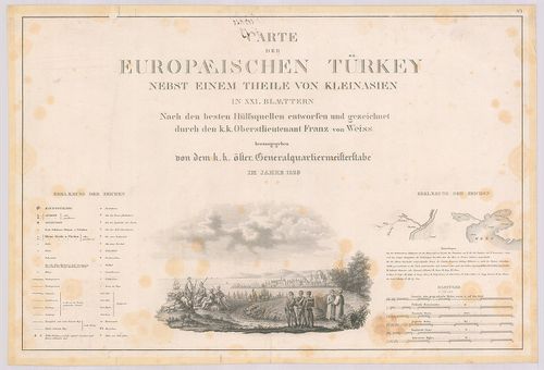
| Title | Carte der Europaeischen Türkey nebst einem Theile von Kleinasien. |
| Main title | 8 mt.: 1. Plan von Belgrad. 2. Plan bon Butrinto. (Butrint, Alb.) 3. Plan von Prevesa. (Gör.) 4. Plan von Dardanellen von Leponto. (Dardanellák) 5. Plan von des Isthums von Korint. (Korinthosz-szoros) 6. Plan des Hafen von Navarin. (Pylosz, Gör.) 7. Plan der Rodos. (Rodosz, Gör.) 8. Plan von Smyrna. (Izmir)Európai Törökország és Kisázsiai egy részének térképe 1829-ben. |
| Scale |
[M. 1:576 000.]
Normalized: 576000 |
| Contributor | Készítő: WEISS, Franz |
| Technical features |
Kiadó:
Wien, 1829. K. k. Osterr. G. Q. St.
Szerzeményszám: 602 21 csatl. tl. egyenként: 62×40 cm. (a 2. lapon szelv. hál.) Hr. cs. Rézm. Jelmagy. Stat. tábl. |
| Source | Institute and Museum of Military History • B III a • B III Balkán-félsziget • B I–XV. Európa |
[21 images]
Content provider
ⓒ Copyright Info: Any publication of the present digital material requires permission from the content provider. To reach content provider directly, click on „Contact”.