Puszta Sz.[ent] Lőrincz vidékének földtani talajtérképe. Ráh... [B IX b 395]
| Reference code | B IX b 395 |
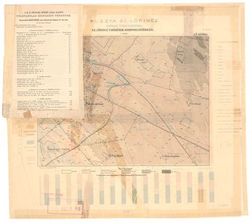
| Title | Puszta Sz.[ent] Lőrincz vidékének földtani talajtérképe. Ráhelyezett oleátán Szentlőrinc vidékének domborzati térképe, hipsz., magassági adatok. |
| Main title | Geológiai térkép. |
| Scale |
M. 1:25 000.
Normalized: 25000 |
| Contributor | Készítő: INKEY Béla |
| Technical features |
Kiadó:
Bp. 1891. M. Kir. földtani int. Ny. Grund V. utódai.
Szerzeményszám: 32368 37×27,5 cm. Szín. Színmagy. „A m. Kir. földtani intézet évkönyve, X. köt. II. tábla.” c. mű mell. |
| Source | Institute and Museum of Military History • B IX b • B IX Ausztria–Magyarország • B I–XV. Európa |
[3 images]
Content provider
ⓒ Copyright Info: Any publication of the present digital material requires permission from the content provider. To reach content provider directly, click on „Contact”.