Geographica Provinciarvm Sveviae Descriptio Schwaben, in XXV... [B IV a 633]
| Reference code | B IV a 633 |
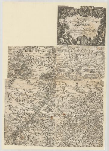
| Title | Geographica Provinciarvm Sveviae Descriptio Schwaben, in XXVIII übereintreffenden Tabellen vorgestellet. |
| Main title | A Svábföld földrajzi térképe 1629 körül. |
| Scale |
[M. 1:300 000.]
Normalized: 300000 |
| Contributor | Készítő: HURTER, Ioh.[ann] Christoph |
| Technical features |
Kiadó:
Metsz.: Hans Georg Bodenehr. Augspurg. [1629] K. n.
4 csatl. tl. egyenként: 45×65 cm. Hr. vakondt. Rézm. Vv. Alleg. címdísz. címerd. Jelmagy. szakadozott. |
| Source | Institute and Museum of Military History • B IV a • B IV Német birodalom • B I–XV. Európa |
[4 images]
Content provider
ⓒ Copyright Info: Any publication of the present digital material requires permission from the content provider. To reach content provider directly, click on „Contact”.