Ethnographische Karte des Königreichs Ungarn sammt Croatien,... [B IX c 120/1]
| Reference code | B IX c 120/1 |
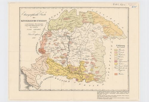
| Title | Ethnographische Karte des Königreichs Ungarn sammt Croatien, Slavonien, der Ungarischen Militärgrenze und der Seeküste. |
| Main title | A Magyar Királyság, Horvátország, Szlavónia, a Határőrvidék és a Magyar Tengerpart néprajzi térképe 1829-ben. |
| Scale |
[M. 1:2 225 000]
Normalized: 2225000 |
| Contributor | Készítő: CSAPLOVICS, Johann |
| Technical features |
Kiadó:
H. n. 1829. K. n. 37×28 cm.
Szerzeményszám: 8295 Szín. Színmagy. Lipszky után átdolgozva |
| Source | Institute and Museum of Military History • B IX c • B IX Ausztria–Magyarország • B I–XV. Európa |
[2 images]
Content provider
ⓒ Copyright Info: Any publication of the present digital material requires permission from the content provider. To reach content provider directly, click on „Contact”.