Map of the Battle Field of Gettysburg july 1st. 2nd. 3rd. 18... [H IV c 137]
| Reference code | H IV c 137 |
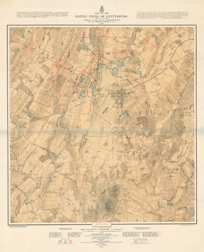
| Title | Map of the Battle Field of Gettysburg july 1st. 2nd. 3rd. 1863. |
| Main title | A gettysburgi (USA) csata (Pennsylvania) helyszínrajza. 1863. Az északi és déli haderők állásának három szakasza az észak-amerikai háborúban. Parancsnokok nevei. |
| Scale |
[M. 1:12 000.]
Normalized: 12000 |
| Contributor | Készítő: BACHELDER, John B. |
| Technical features |
Kiadó:
Metsz. Julius Bien-Louis E. Neumann. Boston (Mass.) 1876. Secretary of War Office of the Chief of Engineers U. S. Army. Ny.: Endicott and Co. N. Y.
3 térk. lap. egyenként: 69×73 cm. Szín. Hr. szv. Jelmagy. |
| Source | Institute and Museum of Military History • H IV c (1841–1913) • H IV Újabbkori háborúk • H Háborúk |
[3 images]
Content provider
ⓒ Copyright Info: Any publication of the present digital material requires permission from the content provider. To reach content provider directly, click on „Contact”.