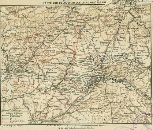
Karte zum Feldzug an der Loire und Sarthe. [H IV c 262/3]
| Reference code | H IV c 262/3 |
| Title | Karte zum Feldzug an der Loire und Sarthe. |
| Main title | A Loire–Sarthe (Fr.) közötti hadjárat térképe. (Német–francia háború 1870–71.) A hadjárat útvonalai bejelölve. |
| Scale |
[M. 1:900 000.]
Normalized: 900000 |
| Contributor | Készítő: TANERA, [ ] |
| Technical features |
Kiadó:
München [187?] C. H. Beck. Ny.: Wagner und Debes, Leipzig.
Szerzeményszám: 8857 22×19 cm. Szín. Hr. cs. Jelmagy. |
| Source | Institute and Museum of Military History • H IV c (1841–1913) • H IV Újabbkori háborúk • H Háborúk |
Content provider
ⓒ Copyright Info: Any publication of the present digital material requires permission from the content provider. To reach content provider directly, click on „Contact”.