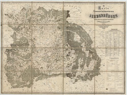
Karte des Grossfürstenthums Siebenbürgen. [B IX a 708]
| Reference code | B IX a 708 |
| Title | Karte des Grossfürstenthums Siebenbürgen. |
| Main title | Erdély térképe 1854-ben. |
| Scale |
[M. 1:430 000.]
Normalized: 430000 |
| Contributor | Készítő: MERSICH, Andreas |
| Technical features |
Kiadó:
Lith. I. Bässler. Hermannstadt. (Sibiu.) 1854. F. R. Krabs.
Szerzeményszám: 591 90×67 cm. Öh. 23,5 cm. Szín. Hr. árny. és cs. Címerd. Ker. beosztás. Vv. |
| Source | Institute and Museum of Military History • B IX a • B IX Ausztria–Magyarország • B I–XV. Európa |
Content provider
ⓒ Copyright Info: Any publication of the present digital material requires permission from the content provider. To reach content provider directly, click on „Contact”.