541. Neueste Postkarte der Oesterreichischen Monarchie. [B IX a 795/b]
Institute and Museum of Military History •
B IX a
•
B IX Ausztria–Magyarország
•
B I–XV. Európa
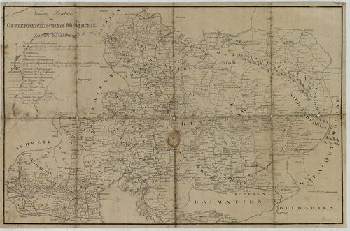
| Title | Neueste Postkarte der Oesterreichischen Monarchie. |
| Main title | Az Osztrák Monarchia postatérképe a 19. század elején. |
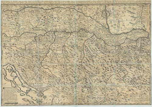
542. Der Lauf des Donau Stroms von Wien bis an das Schwarze Meer ... [B IX a 795/c]
Institute and Museum of Military History •
B IX a
•
B IX Ausztria–Magyarország
•
B I–XV. Európa
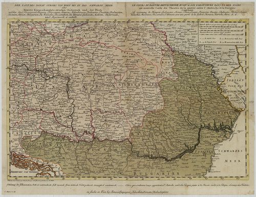
| Title | Der Lauf des Donau Stroms von Wien bis an das Schwarze Meer oder Neuester Kriegschauplatz zwischen Oesterreich und der Pforte welcher das Koenigreich Ungarn, Sclavonien, Sirymien, Siebenbürgen, Bukowina, Croatien, Dalmatien, Bosnien, Servien, Bulgarien, die Walachei, Bessarabien die Ukraine Galizien, Maehren, Oesterreichs und Steyermark etc. enthält. – Le Cours du Danube depuis Vienne jusqu’ á son embouchure dans la Mer Noire ou nouvelle Carte du Theatre de lá guerre entre l’Autriche et la Turquie… |
| Main title | A Duna menti országok térképe 1800 körül. (Bécstől a Fekete-tengerig.) |
543. Tekéntetes Nemes Baranya Vármegyében helyheztetett Dárdai Ur... [B IX a 795/d]
Institute and Museum of Military History •
B IX a
•
B IX Ausztria–Magyarország
•
B I–XV. Európa
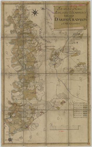
| Title | Tekéntetes Nemes Baranya Vármegyében helyheztetett Dárdai Urodalom Ábrázolattya. |
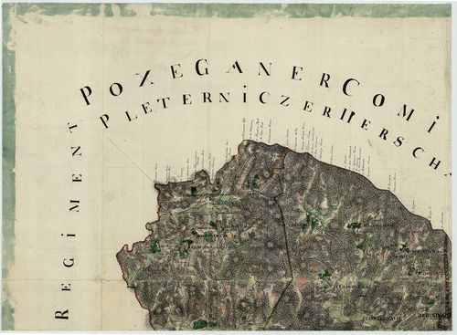
544. Plan des I.-ten [ersten] Banal Gränz Regiments. No. 10. [B IX a 844]
Institute and Museum of Military History •
B IX a
•
B IX Ausztria–Magyarország
•
B I–XV. Európa
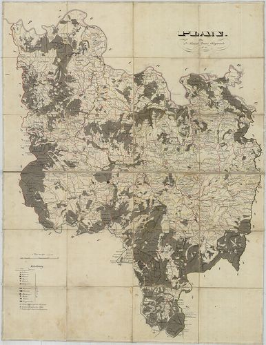
| Title | Plan des I.-ten [ersten] Banal Gränz Regiments. No. 10. |
| Main title | Az I. báni határőrezred területének térképe a 18. század végén, az I. katonai felmérés alapján. |
545. Comitatus Varasdiensis. [B IX a 858]
Institute and Museum of Military History •
B IX a
•
B IX Ausztria–Magyarország
•
B I–XV. Európa
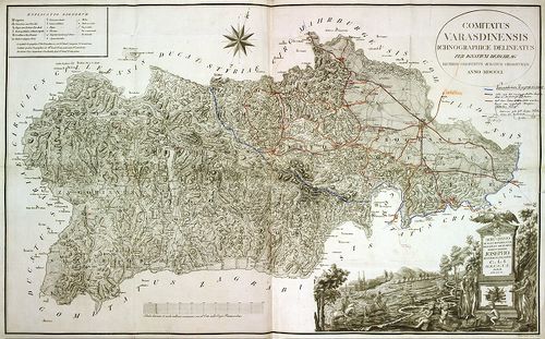
| Title | Comitatus Varasdiensis. |
| Main title | Varasd vármegye térképe 1802-ben. |
546. Mappa doecesis Zagrabiensis. Per Inclytos Comitatus Zagrabie... [B IX a 862]
Institute and Museum of Military History •
B IX a
•
B IX Ausztria–Magyarország
•
B I–XV. Európa
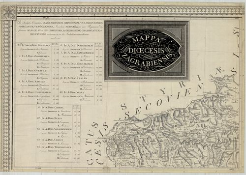
| Title | Mappa doecesis Zagrabiensis. Per Inclytos Comitatus Zagrabiensem, Crisiensem, Varasdiensem, Poseganum, Veröczensem, Insulam Muraköz, nec non Regimina Confiniaria Banale I.-um et 2.-um Crisiense, S. Georgiense, Gradiscanum, et Szluiense extensae, ac in 15. archidiaconatus divisae, scilicet. |
| Main title | A Zagrabi egyházmegye térképe 1822-ben. |
547. Charte von Slavonien enthaltend die Poscheganer, Werowitzer ... [B IX a 871]
Institute and Museum of Military History •
B IX a
•
B IX Ausztria–Magyarország
•
B I–XV. Európa
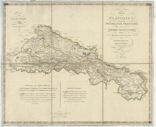
| Title | Charte von Slavonien enthaltend die Poscheganer, Werowitzer und Syrmier Gespannschaft nebst den Gradiscaner, Broder und Peterwardeiner Militair Gränz Districten. – Carte de la Slavonie. |
| Main title | Szlavónia - Pozsega, Verőce, Szerém vármegye és a Katonai Határőrvidék: Gradiska, Brod, Pétervárad-kerület térképe 1803-ban. |
548. Tabula Geographica nova et exacta distincte exhibens Regnum ... [B IX a 873]
Institute and Museum of Military History •
B IX a
•
B IX Ausztria–Magyarország
•
B I–XV. Európa
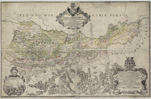
| Title | Tabula Geographica nova et exacta distincte exhibens Regnum Sclavoniae cum Syrmii Ducatu quod fluviis Savi Illovae Dravi et Danubii alluitur eius Provintiae Conterminae sunt Regnum Hungariae Croatiae Bosniae Serviae et Bannatus Temeswariensis. |
| Main title | Szlavónia földrajzi térképe (Gradatz-tól, Gjurgevac – Belgrádig, Beograd.) 1718-ban. |
549. Plan der Sclavonischen Granitz Regimentern. [B IX a 882]
Institute and Museum of Military History •
B IX a
•
B IX Ausztria–Magyarország
•
B I–XV. Európa
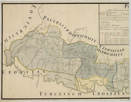
| Title | Plan der Sclavonischen Granitz Regimentern. |
| Main title | A Szlavónia Határőrezred területének térképe a 18. században. |
550. Tabula Geographica exhibens Regnum Sclavoniae cum Syrmii Duc... [B IX a 883]
Institute and Museum of Military History •
B IX a
•
B IX Ausztria–Magyarország
•
B I–XV. Európa
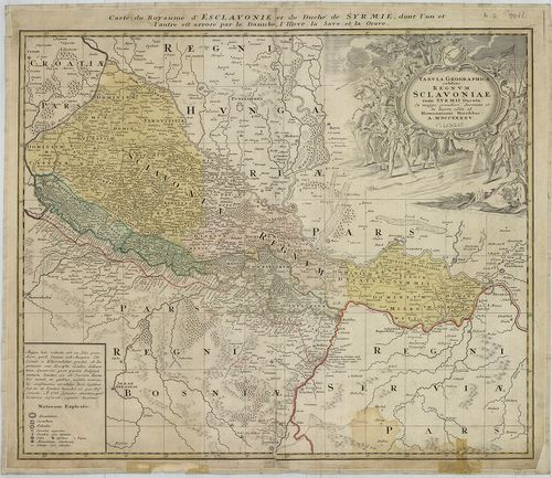
| Title | Tabula Geographica exhibens Regnum Sclavoniae cum Syrmii Ducatu. – Carte du Royaume d’Esclavonie et du Duche de Syrmie… |
| Main title | Szlavónia és a Szerémség térképe 1745-ben. |
551. Karte von der Total Laage des Löbl: Slavonischen Broodae Inf... [B IX a 888]
Institute and Museum of Military History •
B IX a
•
B IX Ausztria–Magyarország
•
B I–XV. Európa
| Title | Karte von der Total Laage des Löbl: Slavonischen Broodae Infanterie Regiment. |
| Main title | Szlavónia: a Brodi Határőrezred területének topográfiai térképe a 18. században, az I. kat. felm. alapján. |
552. Karte von Croatien und Slavonien. – Zemljovid Hérvatske i Sl... [B IX a 890/1]
Institute and Museum of Military History •
B IX a
•
B IX Ausztria–Magyarország
•
B I–XV. Európa
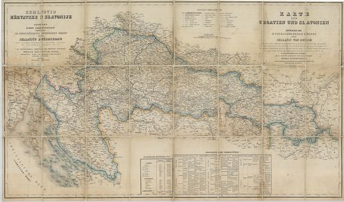
| Title | Karte von Croatien und Slavonien. – Zemljovid Hérvatske i Slavonije. |
| Main title | Horváth-Szlavónia térképe 1882-ben. |
553. Koenigreich Slavonien. [B IX a 890/3]
Institute and Museum of Military History •
B IX a
•
B IX Ausztria–Magyarország
•
B I–XV. Európa
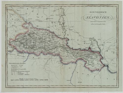
| Title | Koenigreich Slavonien. |
| Main title | A Szlavón Királyság térképe az 1800-as évek elején. (Jasenovac–Beograd között.) |
554. Iustissimiae Causae Heroica Virtute propugnatae, gloriasis: ... [B IX a 890/4]
Institute and Museum of Military History •
B IX a
•
B IX Ausztria–Magyarország
•
B I–XV. Európa
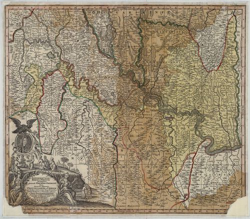
| Title | Iustissimiae Causae Heroica Virtute propugnatae, gloriasis: Triumphi Praemium. Sive Accurata delineatio Provinciarum et Urbium, Quae duabus celeberrimis Expeditionibus Iusto Domino ac Viktori restitutae et Pace Passarowiensi. A. 1718. |
| Main title | Az osztrák–török határvidék térképe az 1718. évi pozsareváci békekötés után, határvonal és tartományi színezéssel. |
555. Horvát-Szlavon Ország. [B IX a 890/5]
Institute and Museum of Military History •
B IX a
•
B IX Ausztria–Magyarország
•
B I–XV. Európa
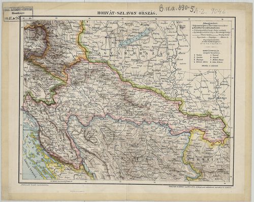
| Title | Horvát-Szlavon Ország. |
556. [A Szlavon Határőrvidék és a Temesi-Bánság déli része.] [B IX a 892]
Institute and Museum of Military History •
B IX a
•
B IX Ausztria–Magyarország
•
B I–XV. Európa
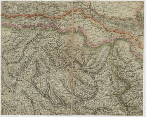
| Title | [A Szlavon Határőrvidék és a Temesi-Bánság déli része.] |
557. Das Gradiskaner Grenz-Regiment. [B IX a 905]
Institute and Museum of Military History •
B IX a
•
B IX Ausztria–Magyarország
•
B I–XV. Európa
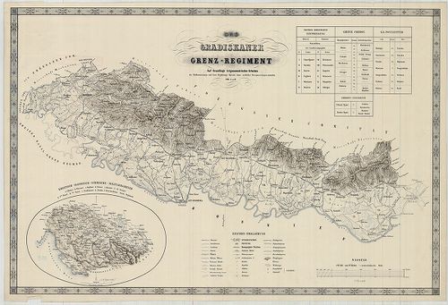
| Title | Das Gradiskaner Grenz-Regiment. |
| Main title | Mt. Kroatisch, Slavonische, Syrmische, Militaer-Grenze. (Horvát-Szlavónia és a Szerémség határőrvidéke.) |
| Subject | Szlavónia: A Gradiškai határőrezred területének térképe a 19. században. |
558. Le Royaume de Bosnie … – Carte Originale et particuliere de ... [B IX a 925]
Institute and Museum of Military History •
B IX a
•
B IX Ausztria–Magyarország
•
B I–XV. Európa
| Title | Le Royaume de Bosnie … – Carte Originale et particuliere de la Bosnie … dans le monde, avec la Croatie, L’esclavonie, la Morlaquie, partie de L’hongria, Stirie, Comté de Cilley, Carenthie, Carniole, parties des Confins maritimes, partie de la D’almatie, Servie, et de L’albanie. |
| Main title | Horvát-Szlavónia és Bosznia térképe 1738-ban. |
559. Bosnien und Dalmatien. [B IX a 930]
Institute and Museum of Military History •
B IX a
•
B IX Ausztria–Magyarország
•
B I–XV. Európa
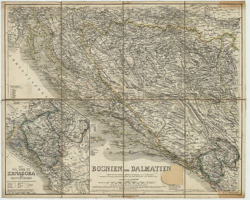
| Title | Bosnien und Dalmatien. |
| Main title | Mt. Das Wladikat Zrnagora oder Montenegro. (Montenegró.) |
| Subject | Bosznia és Dalmácia térképe 1851-ben. |
560. Karte der Hercegovina und Crnagora. [B IX a 931]
Institute and Museum of Military History •
B IX a
•
B IX Ausztria–Magyarország
•
B I–XV. Európa
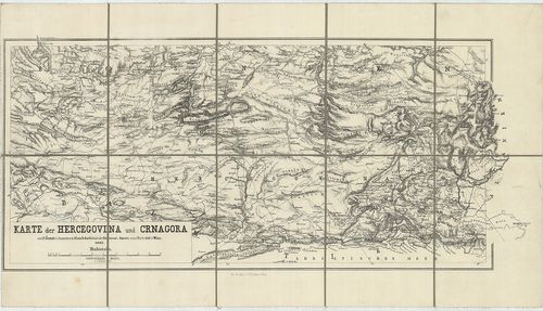
| Title | Karte der Hercegovina und Crnagora. |
| Main title | Hercegovina és Montenegro térképe 1862-ben. |