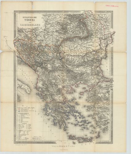
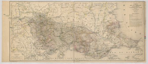
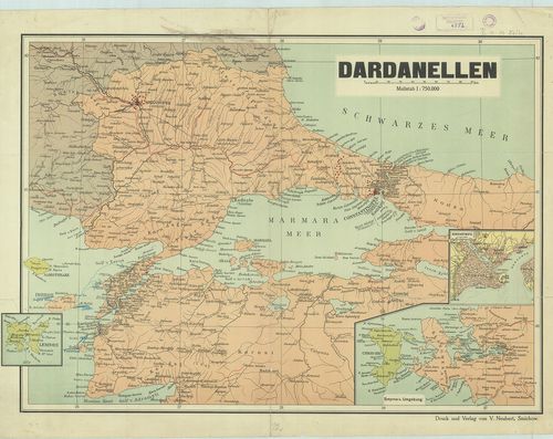
101. Das osmanische Europa oder die europaeische Türkey nebst dem... [B III a 58/2]
Institute and Museum of Military History •
B III a
•
B III Balkán-félsziget
•
B I–XV. Európa
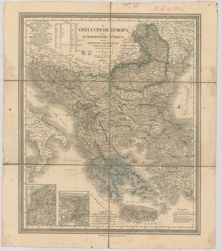
| Title | Das osmanische Europa oder die europaeische Türkey nebst dem Königreich Griechenland und den Jonischen Inseln. |
| Main title | 2 mt.: 1. Dardanellen. (Dardanellák) 2. Constantinopel. (Istanbul)Az európai Törökország, Görögország és Jóni-szigetek térképe 1849-ben. |
102. Das osmanische Europa oder die europaeische Türkey nebst dem... [B III a 59]
Institute and Museum of Military History •
B III a
•
B III Balkán-félsziget
•
B I–XV. Európa
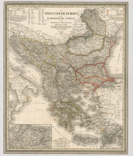
| Title | Das osmanische Europa oder die europaeische Türkey nebst dem Königreiche Griechenland und dem Jonischen Inseln. |
| Main title | 3 mt. 1. Die Dardanellen. (Dardanellák) 2. Constantinopel (Istanbul) 3. [Boszporusz.]Az európai Törökország, Görögország és Jóni-szigetek térképe. |
103. General-Karte der Europaischen Turkei und des Vladikats Mont... [B III a 59/b]
Institute and Museum of Military History •
B III a
•
B III Balkán-félsziget
•
B I–XV. Európa
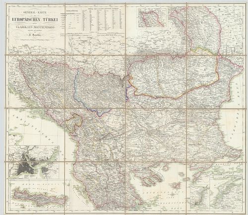
| Title | General-Karte der Europaischen Turkei und des Vladikats Montenegro. |
| Main title | 4 mt.: 1. [Konstantinopel] (Istanbul) |
| Subject | 2. Kréta. |
104. Südost-Europa von Vorder-Asien oder Türkei und Griechenland. [B III a 60]
Institute and Museum of Military History •
B III a
•
B III Balkán-félsziget
•
B I–XV. Európa
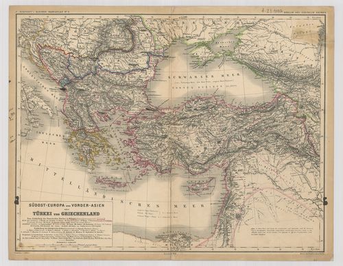
| Title | Südost-Europa von Vorder-Asien oder Türkei und Griechenland. |
| Main title | Délkelet-Európa, Kisázsia és Görögország térképe 1875-ben. |
105. Russisch–Türkischen Kriegsschauplatz in Europa und Asien. [B III a 60/1]
Institute and Museum of Military History •
B III a
•
B III Balkán-félsziget
•
B I–XV. Európa
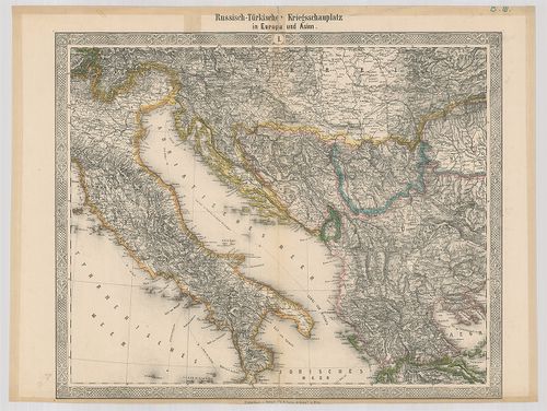
| Title | Russisch–Türkischen Kriegsschauplatz in Europa und Asien. |
| Main title | Az orosz–török hadszínterek Európában és Ázsiában 1877–78-ban. |
106. Karte den Europäischen Türkey nebst Theilen von Klein Asien,... [B III a 60/2]
Institute and Museum of Military History •
B III a
•
B III Balkán-félsziget
•
B I–XV. Európa
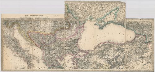
| Title | Karte den Europäischen Türkey nebst Theilen von Klein Asien, Russland und das Schwarze Meer. |
| Main title | Az európai Török Birodalom, Kis-Ázsia, Oroszország és a Fekete-tenger környékének térképe. |
107. Törökország [európai része]. [B III a 60/3]
Institute and Museum of Military History •
B III a
•
B III Balkán-félsziget
•
B I–XV. Európa
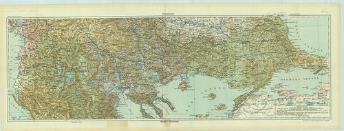
| Title | Törökország [európai része]. |
108. Türkei. Ahmetler Obasi. Blatt: Nr. VII. 29. [B III a 61]
Institute and Museum of Military History •
B III a
•
B III Balkán-félsziget
•
B I–XV. Európa
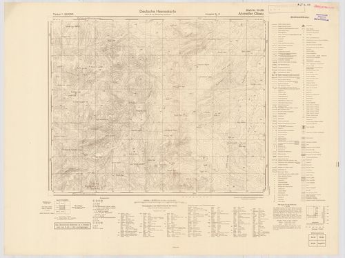
| Title | Türkei. Ahmetler Obasi. Blatt: Nr. VII. 29. |
109. Turkey. – Asia Minor. [B III a 61/1]
Institute and Museum of Military History •
B III a
•
B III Balkán-félsziget
•
B I–XV. Európa
| Title | Turkey. – Asia Minor. |
110. Türkiye. [B III a 61/2]
Institute and Museum of Military History •
B III a
•
B III Balkán-félsziget
•
B I–XV. Európa
| Title | Türkiye. |
111. General-Karte von der europäischen Türkei… [B III a 62]
Institute and Museum of Military History •
B III a
•
B III Balkán-félsziget
•
B I–XV. Európa
| Title | General-Karte von der europäischen Türkei… |
| Main title | 3 mt. 1. Das Wladikat zrnagora oder Montenegro. (Montenegró térképe.) |
| Subject | 2. Der befestigte südliche Theil der Dardanellen Strasse. (Dardanellák). |
112. Karte des Bosporus und der Bithynischen Halbinsel… [B III a 62/1]
Institute and Museum of Military History •
B III a
•
B III Balkán-félsziget
•
B I–XV. Európa
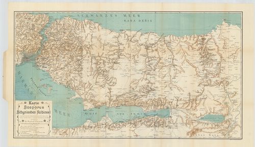
| Title | Karte des Bosporus und der Bithynischen Halbinsel… |
| Main title | Boszporusz és a Bithyniai-félsziget térképe 1900-ben. |
113. Karte der asiatischen Türkei. [B III a 62/2]
Institute and Museum of Military History •
B III a
•
B III Balkán-félsziget
•
B I–XV. Európa
| Title | Karte der asiatischen Türkei. |
114. Carte de Constantinople avec ses Faubourgs le port, le Bosph... [B III a 63]
Institute and Museum of Military History •
B III a
•
B III Balkán-félsziget
•
B I–XV. Európa
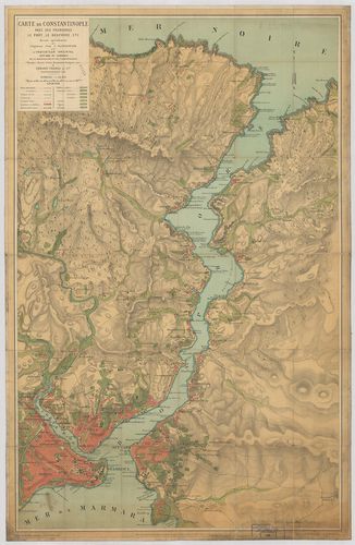
| Title | Carte de Constantinople avec ses Faubourgs le port, le Bosphore etc. |
| Main title | Boszporusz és Istanbul térképe 1887-ben. |
115. Plan de Constantinople et du Bosphore. [B III a 63/1]
Institute and Museum of Military History •
B III a
•
B III Balkán-félsziget
•
B I–XV. Európa
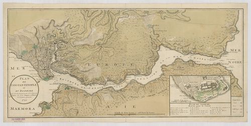
| Title | Plan de Constantinople et du Bosphore. |
| Main title | Mt.: Plan du Serrail. (A Palota térképe.) |
| Subject | Istanbul és a Boszporusz térképe 1788-ban. |
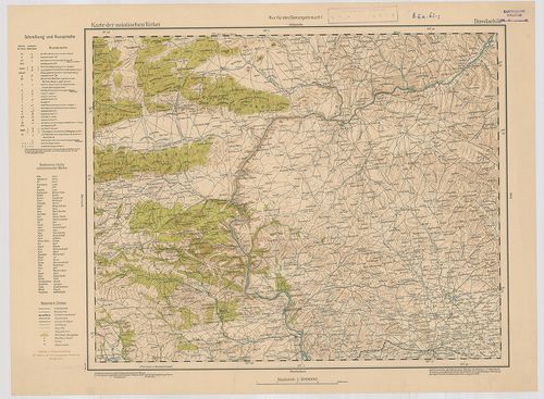
116. General-Karte der Europaeischen Türkey und des Königreich Gr... [B III a 64]
Institute and Museum of Military History •
B III a
•
B III Balkán-félsziget
•
B I–XV. Európa
| Title | General-Karte der Europaeischen Türkey und des Königreich Griechenland. |
| Main title | Mt.: Plan von Constantinople. (Konstantinápoly és környéke.) |
| Subject | Europai Törökország és a Görög Királyság általános térképe 1869-ben. |
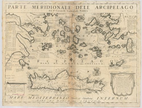
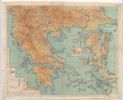
117. Europaeische Türkei und Griechenland. – Borítócím: Übersicht... [B III a 64/1]
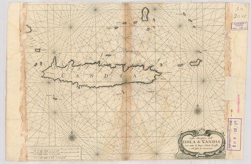
Institute and Museum of Military History •
B III a
•
B III Balkán-félsziget
•
B I–XV. Európa
| Title | Europaeische Türkei und Griechenland. – Borítócím: Übersichtskarte der Europäischen Türkei und des Königreich Griechenland. |
| Main title | Európai Törökország és Görögország térképe 1876-ban. |
118. General-Karte der Europäischen Türkei. – Borítócím: General-... [B III a 65]
Institute and Museum of Military History •
B III a
•
B III Balkán-félsziget
•
B I–XV. Európa
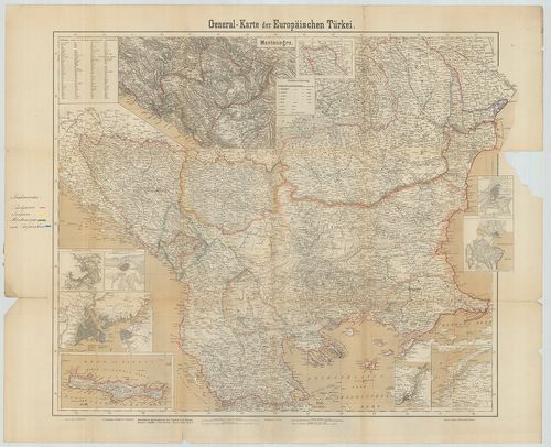
| Title | General-Karte der Europäischen Türkei. – Borítócím: General-Karte der Europäischen Türkei und Montenegro’s. |
| Main title | 9 mt.: 1. Montenegro. 2. Umgebung von Schumla. (Kolarovgrad, Bulg. és környéke.) 3. Umgebung von Silistria. (Szilisztra, Bulg. és környéke.) 4. [Konstantinopel.] |
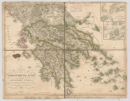
| Subject | 5. [Kréta.] |
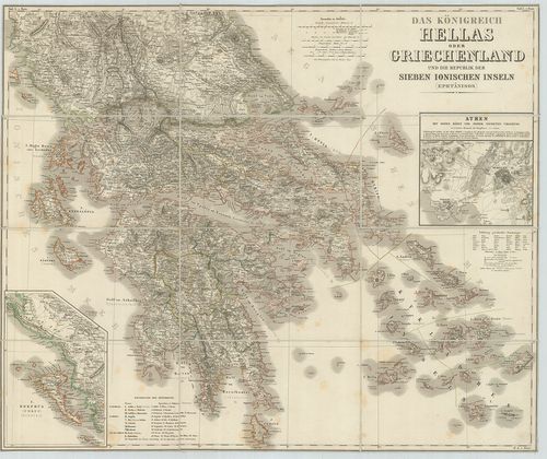
119. Special-Karte der Europäischen Türkei in 20 Blättern. [B III a 66]
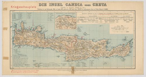
Institute and Museum of Military History •
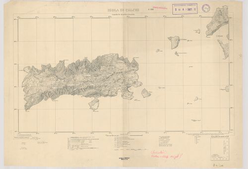
B III a
•
B III Balkán-félsziget
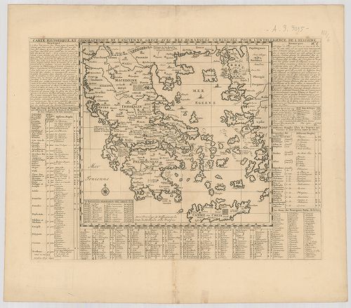
•
B I–XV. Európa
| Title | Special-Karte der Europäischen Türkei in 20 Blättern. |
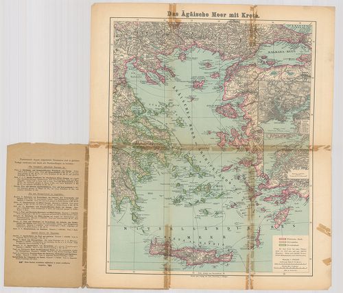
| Main title | Az Európai Törökország részletes térképe 20 szelvényen. |
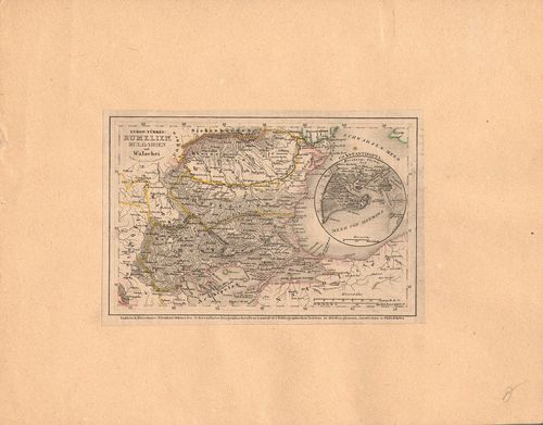
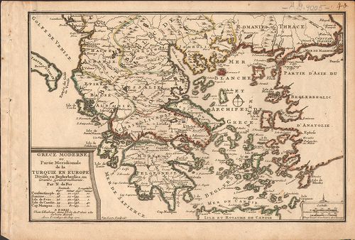
120. Europ[aische] Türkey: Rumelien, Bulgarien und Wallachei. [B III a 67]
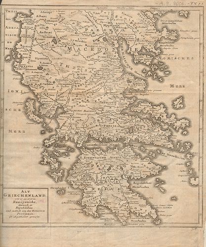
Institute and Museum of Military History •
B III a
•
B III Balkán-félsziget
•
B I–XV. Európa
| Title | Europ[aische] Türkey: Rumelien, Bulgarien und Wallachei. |
| Main title | Mt.: Constantinopel. (Istanbul.)Európai Törökország, Rumélia, Bulgária és a Havasalföld térképe. |
121. Karte der Europäischen Türkei. [B III a 68]
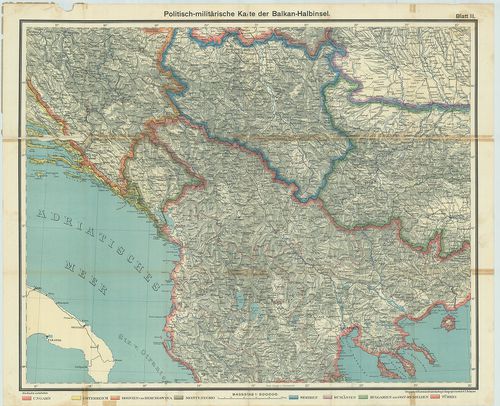
Institute and Museum of Military History •
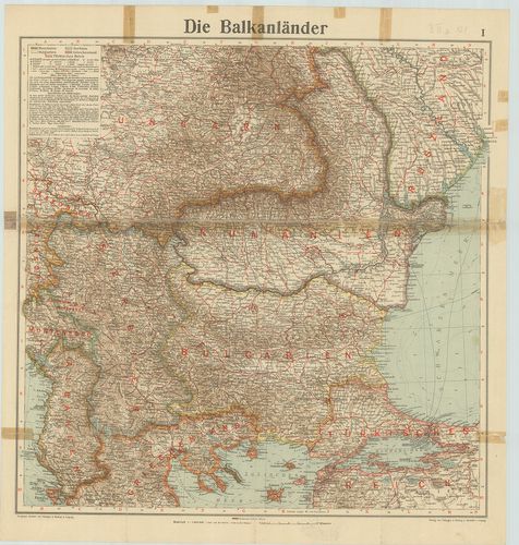
B III a
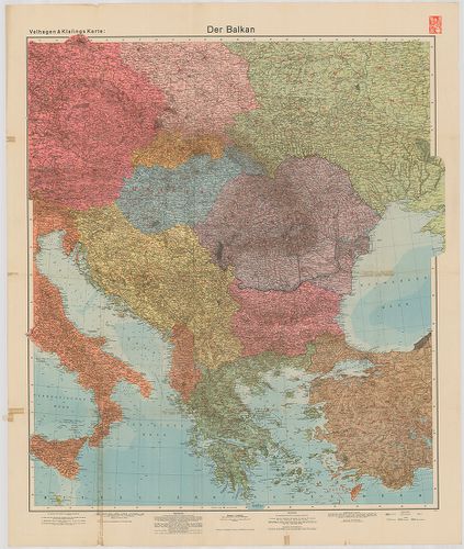
•
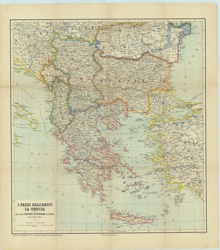
B III Balkán-félsziget
•
B I–XV. Európa
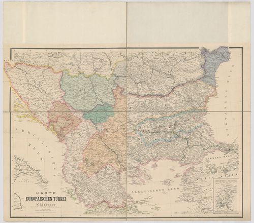
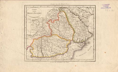
| Title | Karte der Europäischen Türkei. |
| Main title | Mt.: Constantinopel und der Bosporus. (Istanbul és a Boszporusz.)Európai Törökország térképe. |
122. Handkarte der Europäischen Türkei, Bulgarien und Ost-Rumelie... [B III a 70]
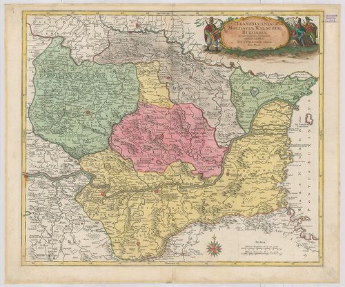
Institute and Museum of Military History •
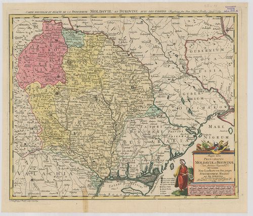
B III a
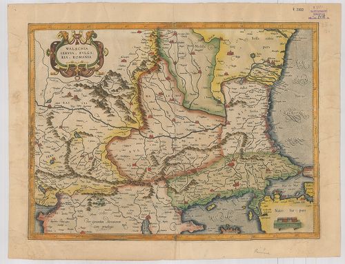
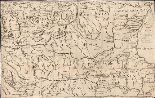
•
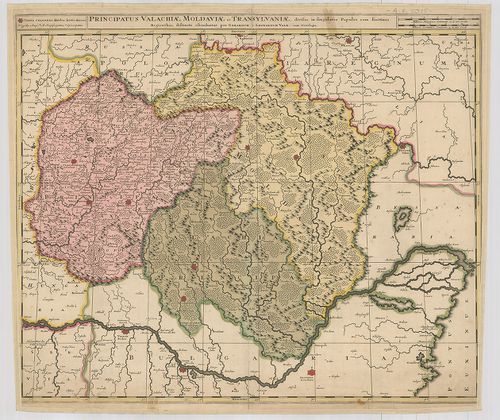
B III Balkán-félsziget
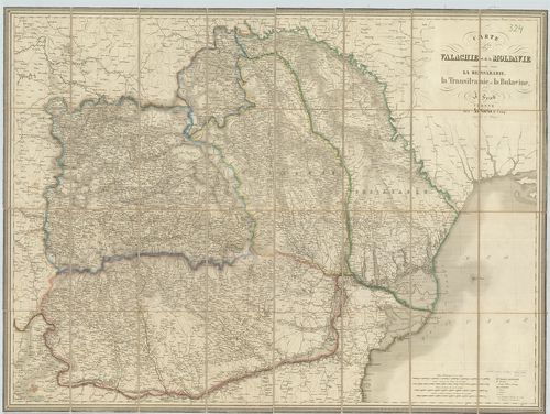
•
B I–XV. Európa
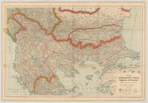
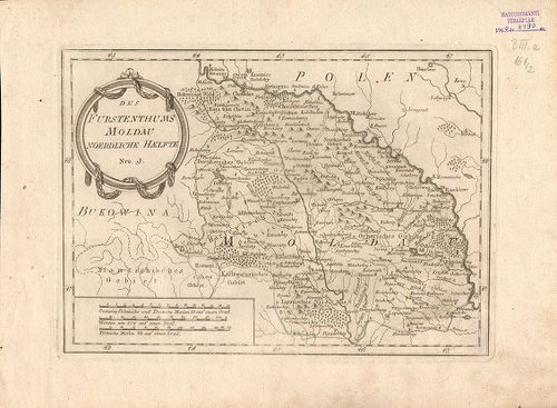
| Title | Handkarte der Europäischen Türkei, Bulgarien und Ost-Rumelien. |
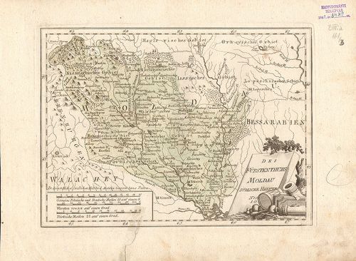
| Main title | Európai Törökország, Bulgária és K-Rumélia térképe. |
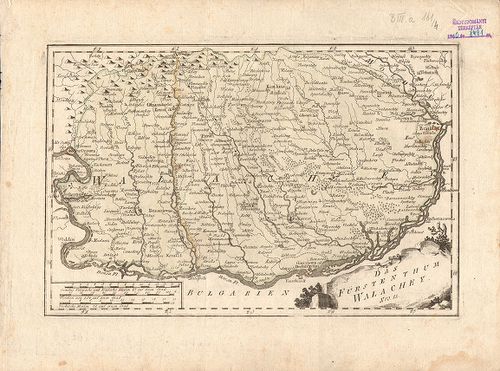
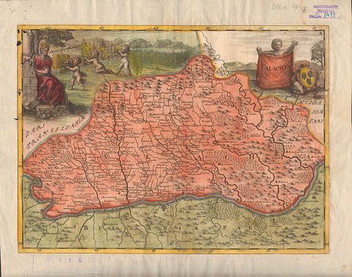
123. Die Landschaft Romanien. Nr. 16. (Kirkekklesische und Gallip... [B III a 70/1]
Institute and Museum of Military History •
B III a
•
B III Balkán-félsziget
•
B I–XV. Európa
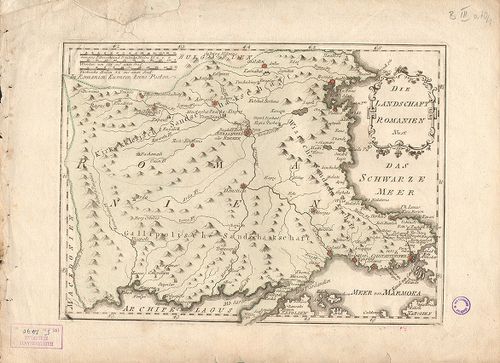
| Title | Die Landschaft Romanien. Nr. 16. (Kirkekklesische und Gallipolosche Sandschakschaft.) |
| Main title | Adrianopel (Edirne) környékének térképe. |
124. [A Balkán-félsziget.] [B III a 72/2]
Institute and Museum of Military History •
B III a
•
B III Balkán-félsziget
•
B I–XV. Európa
| Title | [A Balkán-félsziget.] |
125. [Európai Törökország térképe.] [B III a 72/3]
Institute and Museum of Military History •
B III a
•
B III Balkán-félsziget
•
B I–XV. Európa
| Title | [Európai Törökország térképe.] |
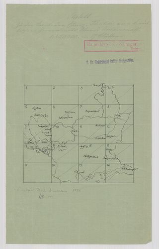
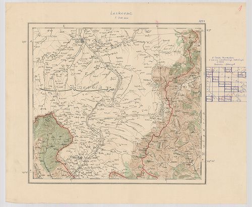
126. [A Török Birodalom és a Balkán félsziget.] [B III a 72/5]
Institute and Museum of Military History •
B III a
•
B III Balkán-félsziget
•
B I–XV. Európa
| Title | [A Török Birodalom és a Balkán félsziget.] |
| Main title | 1. Leskovac. 2. Samakov. 3. Shkodär. 4. Debar. 5. Bitola. 6. Edessza. 7. Kozané. 8. Thesszaloniké. 9. Kerkyra. 10. Arta. 11. Trikala és környéke. |
127. Carte de la partie d’Albanie occupée par la Bacha de Scutari... [B III a 73]
Institute and Museum of Military History •
B III a
•
B III Balkán-félsziget
•
B I–XV. Európa
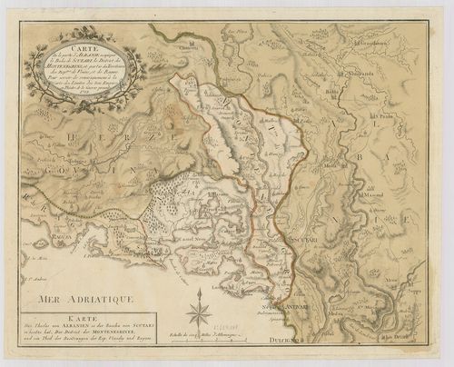
| Title | Carte de la partie d’Albanie occupée par la Bacha de Scutari, le District des Montenegrins, et partie des Territories des Rep. ques de Venise et de Raguse. – Karte des Theiles von Albanien so. der Bacha von Scutari in besitze hat der District der Montenegriner… |
| Main title | Albánia, Montenegró, Dalmácia, Dubrovnik egy részének térképe 1788-ban. |
128. Carte Générale de la Turquie d’Europe, et de la Hongrie. [B III a 73/1]
Institute and Museum of Military History •
B III a
•
B III Balkán-félsziget
•
B I–XV. Európa
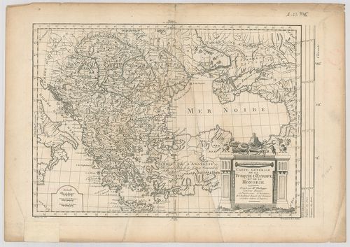
| Title | Carte Générale de la Turquie d’Europe, et de la Hongrie. |
| Main title | Az európai Török Birodalom és Magyarország térképe 1780 körül. |
129. Carte de l’Épire et de la Thessalie. [B III a 74/2]
Institute and Museum of Military History •
B III a
•
B III Balkán-félsziget
•
B I–XV. Európa
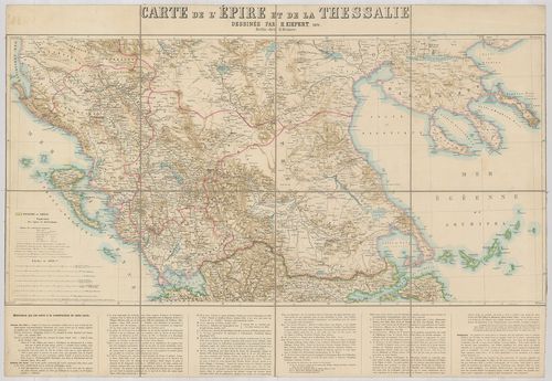
| Title | Carte de l’Épire et de la Thessalie. |
| Main title | Görögország: Thesszália térképe 1871-ben. |
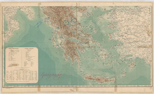
130. [Görögország É-i részének általános térképe.] [B III a 75]
Institute and Museum of Military History •
B III a
•
B III Balkán-félsziget
•
B I–XV. Európa
| Title | [Görögország É-i részének általános térképe.] |
| Main title | É-Thesszália és a határos területek térképe 1897-ben. |
131. Thracia et Illyricum. [B III a 76]
Institute and Museum of Military History •
B III a
•
B III Balkán-félsziget
•
B I–XV. Európa
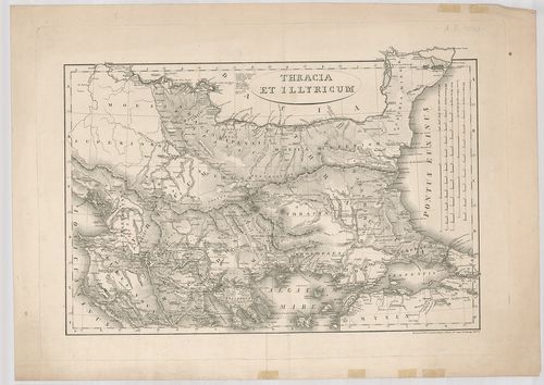
| Title | Thracia et Illyricum. |
| Main title | Trákia és Illiria térképe. |
132. Hellas, Thessalia, Epirus. [B III a 77]
Institute and Museum of Military History •
B III a
•
B III Balkán-félsziget
•
B I–XV. Európa
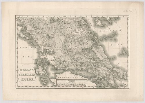
| Title | Hellas, Thessalia, Epirus. |
| Main title | Hellasz, Thesszália, Épeirosz térképe. |
133. Peloponnesus et Cyclades. [B III a 78]
Institute and Museum of Military History •
B III a
•
B III Balkán-félsziget
•
B I–XV. Európa
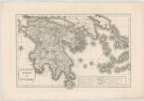
| Title | Peloponnesus et Cyclades. |
| Main title | Peloponnészosz és a Kikládok általános térképe 1822-ben. |
134. Regno di Negroponte. [B III a 79]
Institute and Museum of Military History •
B III a
•
B III Balkán-félsziget
•
B I–XV. Európa
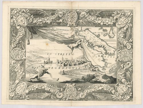
| Title | Regno di Negroponte. |
| Main title | Görögország: Euboia általános térképe. |
135. A Balkán-félsziget politikai, és katonai térképe. II.-ik lap... [B III a 82]
Institute and Museum of Military History •
B III a
•
B III Balkán-félsziget
•
B I–XV. Európa
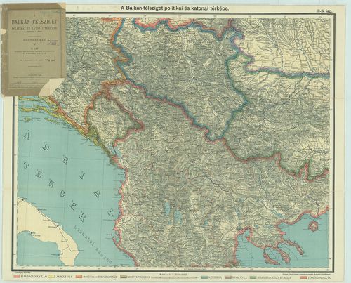
| Title | A Balkán-félsziget politikai, és katonai térképe. II.-ik lap. Albánia, Macedonia, Szerbia, Montenegro és a határos területek. |
136. Karte von Makedonien, Altserbien, und Albanien. [B III a 82/5]
Institute and Museum of Military History •
B III a
•
B III Balkán-félsziget
•
B I–XV. Európa
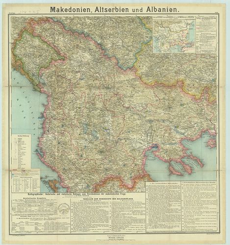
| Title | Karte von Makedonien, Altserbien, und Albanien. |
| Main title | Mt.: Die Sprachlichen Interessensphären in und um Makedonien und Altserbien. (Nyelvi megoszlás Makedóniában és Szerbiában.)Makedónia, Szerbia és Albánia térképe. |
137. Das Sandschak Novi Bazar, Nor-Albanien Neu-Serbien und Monte... [B III a 83]
Institute and Museum of Military History •
B III a
•
B III Balkán-félsziget
•
B I–XV. Európa
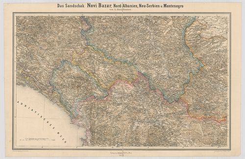
| Title | Das Sandschak Novi Bazar, Nor-Albanien Neu-Serbien und Montenegro. |
| Main title | A Novi Pazar-i, Észak-Albánia-i, Új-Szerbia-i és montenegrói szandzsák környékének térképe 1879-ben. |
138. Carte de la Thrace d’une partie de la Macédonie et de la Moe... [B III a 84]
Institute and Museum of Military History •
B III a
•
B III Balkán-félsziget
•
B I–XV. Európa
| Title | Carte de la Thrace d’une partie de la Macédonie et de la Moesie. |
| Main title | Trákia és Macedónia egy részének térképe 1854-ben. |
139. Europäische Türkei, Dardanellen und Bosporus. [B III a 86]
Institute and Museum of Military History •
B III a
•
B III Balkán-félsziget
•
B I–XV. Európa
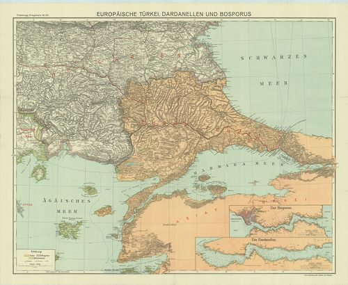
| Title | Europäische Türkei, Dardanellen und Bosporus. |
| Main title | 2 mt.: 1. Der Bosporus. (Boszporusz.) |
| Subject | 2. Die Dardanellen. (Dardanellák.) |
140. Bulgaria és a Dardanellák háborús térképe. [B III a 87/3]
Institute and Museum of Military History •
B III a
•
B III Balkán-félsziget
•
B I–XV. Európa
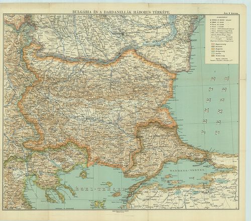
| Title | Bulgaria és a Dardanellák háborús térképe. |
141. Dardanellen. [B III a 87/4]
Institute and Museum of Military History •
B III a
•
B III Balkán-félsziget
•
B I–XV. Európa
| Title | Dardanellen. |
| Main title | 3 mt. 1. Konstantinopel. (Istambul) 2. Lemnos. (Lemnosz) 3. Smyrna und Umgebung. (Izmir. környéke.)A Dardanellák térképe. |
142. [A szerb–bolgár határvidék.] [B III a 89/3]
Institute and Museum of Military History •
B III a
•
B III Balkán-félsziget
•
B I–XV. Európa
| Title | [A szerb–bolgár határvidék.] |
143. Carte meridionale dell… Arcipelago. [B III a 90]
Institute and Museum of Military History •
B III a
•
B III Balkán-félsziget
•
B I–XV. Európa
| Title | Carte meridionale dell… Arcipelago. |
| Main title | Kréta és a környező szigetek térképe. |
144. Coste Maritime dell’ Isola di Candia Con tutte le Baye e Por... [B III a 90/1]
Institute and Museum of Military History •
B III a
•
B III Balkán-félsziget
•
B I–XV. Európa
| Title | Coste Maritime dell’ Isola di Candia Con tutte le Baye e Porti di essa… |
| Main title | Kréta szigetének térképe. |
145. La Grece Ancienne, et Moderne ou Carte Generale des isles et... [B III a 91]
Institute and Museum of Military History •
B III a
•
B III Balkán-félsziget
•
B I–XV. Európa
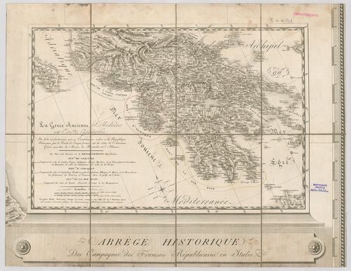
| Title | La Grece Ancienne, et Moderne ou Carte Generale des isles et forteresses cydevant Venitiennes… |
| Main title | Az ókori és a modern Görögország térképe. |
146. [A török–görög háború színhelye, 1885.] [B III a 92]
Institute and Museum of Military History •
B III a
•
B III Balkán-félsziget
•
B I–XV. Európa
| Title | [A török–görög háború színhelye, 1885.] |
147. La Grecia Universale Antica Paragonata con la Moderna da… [B III a 93]
Institute and Museum of Military History •
B III a
•
B III Balkán-félsziget
•
B I–XV. Európa
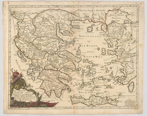
| Title | La Grecia Universale Antica Paragonata con la Moderna da… |
| Main title | Az ókori és modern Görögország térképe. |
148. Les Côtes de la Gréce et l’Archipel. [B III a 94]
Institute and Museum of Military History •
B III a
•
B III Balkán-félsziget
•
B I–XV. Európa
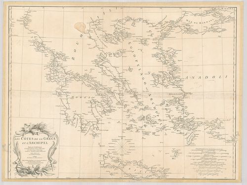
| Title | Les Côtes de la Gréce et l’Archipel. |
| Main title | Görögország és szigeteinek térképe 1756-ban. |
149. Carte comparative de la Gréce. Ancienne-moderne… – Alt und n... [B III a 95]
Institute and Museum of Military History •
B III a
•
B III Balkán-félsziget
•
B I–XV. Európa
| Title | Carte comparative de la Gréce. Ancienne-moderne… – Alt und neu Griechenland. |
| Main title | A régi és az új Görögország térképe. |
150. La Grecia divisa Nelle aue Provincie Di nuova Projezione. [B III a 96]
Institute and Museum of Military History •
B III a
•
B III Balkán-félsziget
•
B I–XV. Európa
| Title | La Grecia divisa Nelle aue Provincie Di nuova Projezione. |
| Main title | Görögország térképe 1781-ben. |
151. Graecia Antique. [B III a 97]
Institute and Museum of Military History •
B III a
•
B III Balkán-félsziget
•
B I–XV. Európa
| Title | Graecia Antique. |
| Main title | Mt.: Graeciae (Laxe sumptae) Partes Boreales.Az ókori Görögország térképe. |
152. Carte de la Grece. [B III a 97/1]
Institute and Museum of Military History •
B III a
•
B III Balkán-félsziget
•
B I–XV. Európa
| Title | Carte de la Grece. |
| Main title | Görögország térképe. |
153. Neueste Karte von Griechenland. No. 37. [B III a 98]
Institute and Museum of Military History •
B III a
•
B III Balkán-félsziget
•
B I–XV. Európa
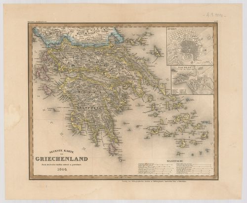
| Title | Neueste Karte von Griechenland. No. 37. |
| Main title | 2 mt.: 1. Athen. 2. Nauplia. (Nauplion) |
| Subject | Görögország térképe 1844-ben. |
154. Carte de la Gréce et de la Turquie d’Europe. [B III a 98/1]
Institute and Museum of Military History •
B III a
•
B III Balkán-félsziget
•
B I–XV. Európa
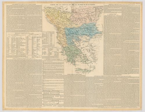
| Title | Carte de la Gréce et de la Turquie d’Europe. |
| Main title | Görögország és az Európai Törökország térképe. |
155. Genikosz chartesz tesz Elladosz. [2. B.] Thesszalia Szter. E... [B III a 99]
Institute and Museum of Military History •
B III a
•
B III Balkán-félsziget
•
B I–XV. Európa
| Title | Genikosz chartesz tesz Elladosz. [2. B.] Thesszalia Szter. Ellasz. [2. c.] Chalkidike [3-A.] Ionioi Neszoi [3. B.] Peloponeszszosz [3. C.] Attike. |
| Main title | Görögország térképe. |
156. General-Karte des Königreiches Griechenland. [B III a 100]
Institute and Museum of Military History •
B III a
•
B III Balkán-félsziget
•
B I–XV. Európa
| Title | General-Karte des Königreiches Griechenland. |
| Main title | Görögország térképe. |
157. [Görögország.] [B III a 100/1]
Institute and Museum of Military History •
B III a
•
B III Balkán-félsziget
•
B I–XV. Európa
| Title | [Görögország.] |
158. Carta della Grecia Antica e Moderna. [B III a 101]
Institute and Museum of Military History •
B III a
•
B III Balkán-félsziget
•
B I–XV. Európa
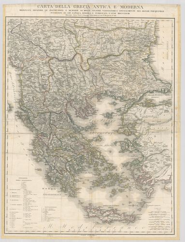
| Title | Carta della Grecia Antica e Moderna. |
| Main title | Görögország térképe 1828-ban. |
159. Griechenland nebst den angrenzenden Ländern mit der neuesten... [B III a 102]
Institute and Museum of Military History •
B III a
•
B III Balkán-félsziget
•
B I–XV. Európa
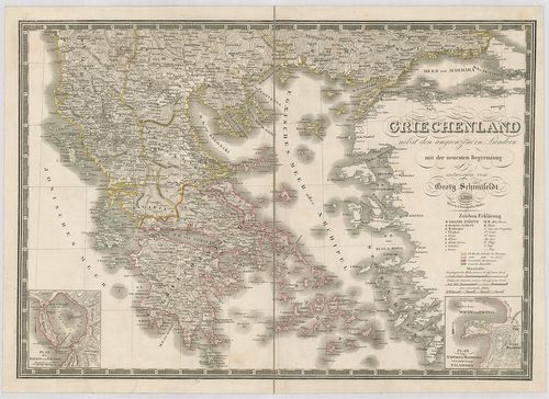
| Title | Griechenland nebst den angrenzenden Ländern mit der neuesten Begrenzung. |
| Main title | 2 mt.: 1. Plan des Hafens von Navarin. (Pylosz kikötője.) 2. Plan von Napoli di Romania und dem Fort Palamides. (Nauplion-öböl.)Görögország és a környező területe térképe 1830-ban. |
160. [Görögország.] [B III a 104/1]
Institute and Museum of Military History •
B III a
•
B III Balkán-félsziget
•
B I–XV. Európa
| Title | [Görögország.] |
161. Griechenland und die Jonischen Inseln mit Beachtung der Klas... [B III a 105]
Institute and Museum of Military History •
B III a
•
B III Balkán-félsziget
•
B I–XV. Európa
| Title | Griechenland und die Jonischen Inseln mit Beachtung der Klassischen Zeit. |
| Main title | 2 mt.: 1. Plan der Gegend zwischen Athen und dem Piraeus. (Athénai és Peiraieusz közötti terület.) 2. Plan von Athén. (Athén térképe.) |
| Subject | Görögország és a Jón-szigetek térképe 1846-ban. |
162. Das Königreich Hellas oder Griechenland und die Republik der... [B III a 106]
Institute and Museum of Military History •
B III a
•
B III Balkán-félsziget
•
B I–XV. Európa
| Title | Das Königreich Hellas oder Griechenland und die Republik der Sieben Jonischen Inseln (Ephtánisos.) |
| Main title | 2 mt.: 1. Korphus. (Corfu, Kerkyra) 2. Athen mit seinen Häfen und nächsten Umgebung. |
| Subject | (Az Athen-i kikötő és környéke.) |
163. Die Insel Candia oder Creta. (Kriti im neugriech: Kirid im T... [B III a 107]
Institute and Museum of Military History •
B III a
•
B III Balkán-félsziget
•
B I–XV. Európa
| Title | Die Insel Candia oder Creta. (Kriti im neugriech: Kirid im Türk.) |
| Main title | Mt.: Das Thal des Mylopotamo im doppelten Masstab der Hauptkarte. (Mylopótama-völgy.) |
| Subject | Kréta szigetének térképe 1862-ben. |
164. Isola di Calchi. [B III a 107/1]
Institute and Museum of Military History •
B III a
•
B III Balkán-félsziget
•
B I–XV. Európa
| Title | Isola di Calchi. |
| Main title | Calchi szigete. |
165. Die Jonische oder Siebeninsel Republik. [B III a 107/2]
Institute and Museum of Military History •
B III a
•
B III Balkán-félsziget
•
B I–XV. Európa
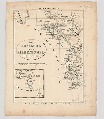
| Title | Die Jonische oder Siebeninsel Republik. |
| Main title | Mt.: Das Aegaeische Meer. (Az Égei-tenger.) |
| Subject | A Jóni-tenger szigeteinek térképe. |
166. Boeotien. (Beócia.) [B III a 107/3]
Institute and Museum of Military History •
B III a
•
B III Balkán-félsziget
•
B I–XV. Európa
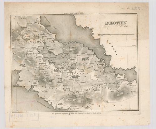
| Title | Boeotien. (Beócia.) |
| Main title | Görögország: Beócia tartomány térképe. |
167. Cronologie historique des Rois, et differents etats de l’Anc... [B III a 107/4]
Institute and Museum of Military History •
B III a
•
B III Balkán-félsziget
•
B I–XV. Európa
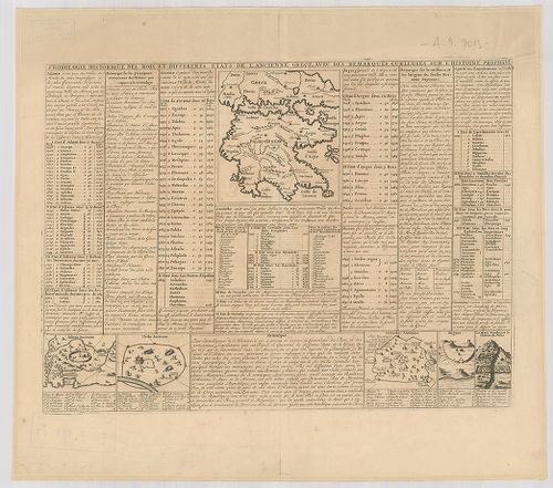
| Title | Cronologie historique des Rois, et differents etats de l’Ancienne Grece… |
| Main title | 5 mt.: 1. Athene Ancienne. (Athenai.) 2. Thébe Ancienne. (Thévai.) 3. Corinthe Ancienne. 4. Megare. (Megare.) 5. Lemont Synthus, et le Chateau de Delos. (A Synthusi-hegy és a Déloszi jóshely.)Az ókori-Görögország térképe. |
168. Carte historique, cronologique, geographique de l’Empire Gre... [B III a 107/5]
Institute and Museum of Military History •
B III a
•
B III Balkán-félsziget
•
B I–XV. Európa
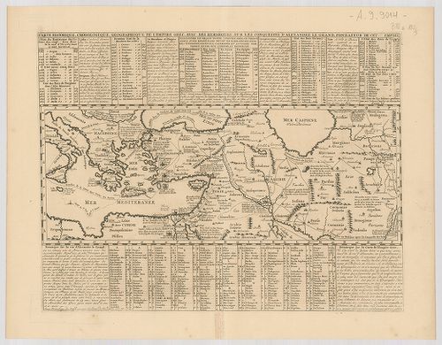
| Title | Carte historique, cronologique, geographique de l’Empire Grec, avec des remarques sur les conquestes d’Alexandre le Grand… |
| Main title | Görögország: Nagy Sándor birodalmának térképe. |
169. Carte historique et geographique de l’ancienne Grece… [B III a 107/6]
Institute and Museum of Military History •
B III a
•
B III Balkán-félsziget
•
B I–XV. Európa
| Title | Carte historique et geographique de l’ancienne Grece… |
| Main title | Az ókori-Görögország térképe. |
170. Das Ägäische Meer mit Kreta. Borítócím: Neue Handkarte vom Ä... [B III a 107/7]
Institute and Museum of Military History •
B III a
•
B III Balkán-félsziget
•
B I–XV. Európa
| Title | Das Ägäische Meer mit Kreta. Borítócím: Neue Handkarte vom Ägäische Meer mit Kreta. |
| Main title | 2 mt.: 1. Constantinopel. (Istanbul.) 2. Dardanellák.Égei-tenger és Kréta szigetének térképe. |
171. Grece moderne ou Partie Meridionale de la Turquie en Europe.... [B III a 108]
Institute and Museum of Military History •
B III a
•
B III Balkán-félsziget
•
B I–XV. Európa
| Title | Grece moderne ou Partie Meridionale de la Turquie en Europe. Divisée en Beglerbeglics, ou Grands Gouvernements. |
| Main title | Görögország térképe 1701-ben. |
172. Alt Griechenland wie es zu erst in Königreiche darnach in Re... [B III a 109]
Institute and Museum of Military History •
B III a
•
B III Balkán-félsziget
•
B I–XV. Európa
| Title | Alt Griechenland wie es zu erst in Königreiche darnach in Republiken und endlich von dem Römern in Provinzen ist abgetheil gewesen. |
| Main title | Az Ókori-Görögország térképe. |
173. Carte Physique, Historique et Routiere de la Gréce… [B III a 110/1]
Institute and Museum of Military History •
B III a
•
B III Balkán-félsziget
•
B I–XV. Európa
| Title | Carte Physique, Historique et Routiere de la Gréce… |
| Main title | 9 mt.: 1. Carte du territoire de Buthrinto. (Butrint, Alb.) |
| Subject | 2. Plan de la ville de Navarin. (Pylosz, Gör.) |
174. Carte du Royaume De la Gréce… [B III a 111]
Institute and Museum of Military History •
B III a
•
B III Balkán-félsziget
•
B I–XV. Európa
| Title | Carte du Royaume De la Gréce… |
| Main title | 2 mt.: 1. Enumeration des Poteaux de la Frontiére continentale entre le Royaume Della Gréce et L’Empire Ottoman. (Görög–török szárazföldi határ térképe számozott határkőjelzés felsorolása.) 2. [Kréta.] |
| Subject | Görögország térképe 1838-ban. |
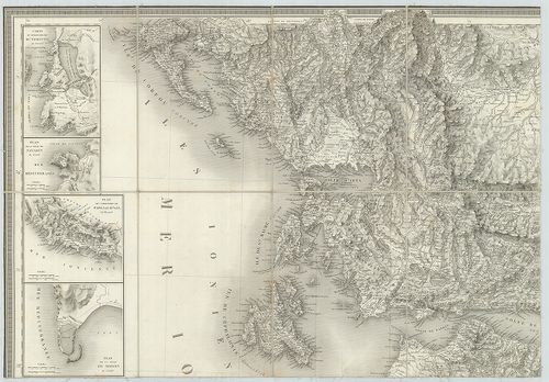
175. Carte de la Gréce. [B III a 112]
Institute and Museum of Military History •
B III a
•
B III Balkán-félsziget
•
B I–XV. Európa
| Title | Carte de la Gréce. |
| Main title | 2 mt.: 1. Carte de la Gréce. |
| Subject | (Görögország) 2. Plan d’Athénes. (Athénai várostérkép.) |
176. [Görögország térképe.] [B III a 113]
Institute and Museum of Military History •
B III a
•
B III Balkán-félsziget
•
B I–XV. Európa
| Title | [Görögország térképe.] |
177. I. Die Insel Candia oder Creta mit dem Blocade Gebiet. – II.... [B III a 114]
Institute and Museum of Military History •
B III a
•
B III Balkán-félsziget
•
B I–XV. Európa
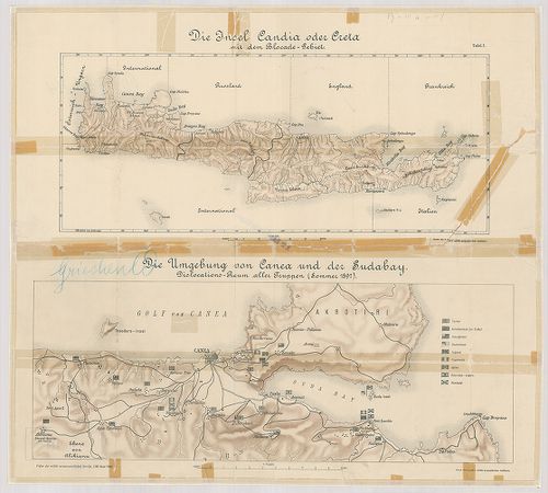
| Title | I. Die Insel Candia oder Creta mit dem Blocade Gebiet. – II. Die Umgebung von Canea und der Sudabay. Dislocations-Raum aller Truppen (Sommer 1897). |
| Main title | Kréta, Canea (Chaniá) és Szuda-öböl (Kréta szigetén) térképe 1897 nyarán. |
178. Görögország. [Középső része.] [B III a 115]
Institute and Museum of Military History •
B III a
•
B III Balkán-félsziget
•
B I–XV. Európa
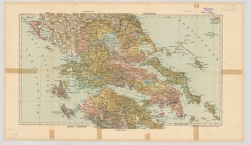
| Title | Görögország. [Középső része.] |
| Main title | Kogutowicz: Teljes Atlasza. (76. lap) |
179. Peleponnesus hodie Morea. Ad normam veterum et recentiorum m... [B III a 116]
Institute and Museum of Military History •
B III a
•
B III Balkán-félsziget
•
B I–XV. Európa
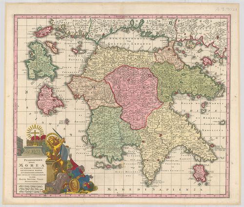
| Title | Peleponnesus hodie Morea. Ad normam veterum et recentiorum mappar accuratissime adornata aeri incisa et venalis exposita. |
| Main title | Peloponnészosz-félsziget és a környező szigetek térképe. |
180. Graecia Nova et Mare Aegeum s. Archipelagus… [B III a 117]
Institute and Museum of Military History •
B III a
•
B III Balkán-félsziget
•
B I–XV. Európa
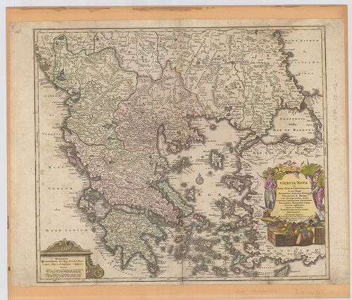
| Title | Graecia Nova et Mare Aegeum s. Archipelagus… |
| Main title | Új-Görögország és a környező szigetek térképe. |
181. Politisch-militärische Karte der Balkan-Halbinsel. II. lap. [B III a 120]
Institute and Museum of Military History •
B III a
•
B III Balkán-félsziget
•
B I–XV. Európa
| Title | Politisch-militärische Karte der Balkan-Halbinsel. II. lap. |
| Main title | A Balkán-félsziget politikai és katonai térképe. |
182. 1. Die Balkanländer. [B III a 121]
Institute and Museum of Military History •
B III a
•
B III Balkán-félsziget
•
B I–XV. Európa
| Title | 1. Die Balkanländer. |
| Main title | 2. Türkisches Reich und Südrussland. |
| Subject | A Balkán-félsziget, Törökország és Dél-Oroszország térképe. |
183. Der Balkan. [B III a 122]
Institute and Museum of Military History •
B III a
•
B III Balkán-félsziget
•
B I–XV. Európa
| Title | Der Balkan. |
| Main title | A Balkán-félsziget és Közép-Európa térképe. |
184. I paesi balcanici la Grecia ed i limiti dell’Impero Ottomano... [B III a 123]
Institute and Museum of Military History •
B III a
•
B III Balkán-félsziget
•
B I–XV. Európa
| Title | I paesi balcanici la Grecia ed i limiti dell’Impero Ottomano in Europa. |
| Main title | A Balkán-félsziget országai és az európai Törökország térképe 1914-ben. |
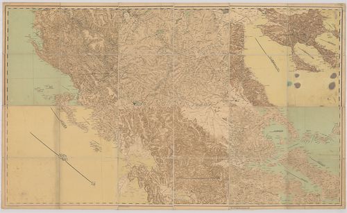
185. [Balkán-félsziget.] 43/G Slovakia (South.), Poland (South.),... [B III a 132/1]
Institute and Museum of Military History •
B III a
•
B III Balkán-félsziget
•
B I–XV. Európa
| Title | [Balkán-félsziget.] 43/G Slovakia (South.), Poland (South.), Hungary (South East), Romania, Serbia, Bulgaria (N central and E.), Croatia (East), Montenegro (East), Albania (North). – Hátoldalon 43/H Grece, Albania, Bulgaria, (South). Turkey in Europe. Turkey in Asia (Western Seaboard), Grete (Kréta) Inset Right. |
| Main title | A Balkán-félsziget országai és a szomszédos területek térképe 1943-ban. |
186. Carta topografica del Isola di Ceffalonia. [B III a 147]
Institute and Museum of Military History •
B III a
•
B III Balkán-félsziget
•
B I–XV. Európa

| Title | Carta topografica del Isola di Ceffalonia. |
187. Principati di Moldavia e Vallachia. Tratti dalle Carte dell ... [B III a 150]
Institute and Museum of Military History •
B III a
•
B III Balkán-félsziget
•
B I–XV. Európa
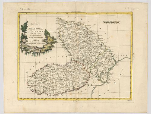
| Title | Principati di Moldavia e Vallachia. Tratti dalle Carte dell Impero Ottomano. |
| Main title | Moldva és a Havasalföld térképe 1782-ben. |
188. Charte von Bessarabien. – Neue Geographie. [B III a 151]
Institute and Museum of Military History •
B III a
•
B III Balkán-félsziget
•
B I–XV. Európa
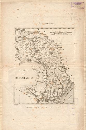
| Title | Charte von Bessarabien. – Neue Geographie. |
| Main title | Besszarábia térképe. |
189. Charte von der Moldau und Walachey. – Charte de la Moldavie ... [B III a 153]
Institute and Museum of Military History •
B III a
•
B III Balkán-félsziget
•
B I–XV. Európa
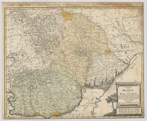
| Title | Charte von der Moldau und Walachey. – Charte de la Moldavie et de la Valachie. |
| Main title | Moldva és a Havasalföld térképe 1785-ben. |
190. Transilvaniae, Moldaviae, Walachiae, Bulgariae, nova et accu... [B III a 154]
Institute and Museum of Military History •
B III a
•
B III Balkán-félsziget
•
B I–XV. Európa
| Title | Transilvaniae, Moldaviae, Walachiae, Bulgariae, nova et accurata… |
| Main title | Erdély, Moldva, Havasalföld és Bulgária. |
191. Mappa nova Principatus Moldaviae et Bucovinae cum finitimis ... [B III a 155]
Institute and Museum of Military History •
B III a
•
B III Balkán-félsziget
•
B I–XV. Európa
| Title | Mappa nova Principatus Moldaviae et Bucovinae cum finitimis Regionibus. – Neue Landkarte von dem jezigen Fürstenthum Moldau mit der Bukovina… |
| Main title | Moldva és Bukovina térképe 1789-ben. |
192. Walachia, Servia, Bulgaria, Románia. [B III a 156]
Institute and Museum of Military History •
B III a
•
B III Balkán-félsziget
•
B I–XV. Európa
| Title | Walachia, Servia, Bulgaria, Románia. |
| Main title | Havasalföld, Szerbia, Bulgária, Románia térképe 1620 körül. |
193. Principatus Valachiae, Moldaviae et Transilvaniae, divisus i... [B III a 157]
Institute and Museum of Military History •
B III a
•
B III Balkán-félsziget
•
B I–XV. Európa
| Title | Principatus Valachiae, Moldaviae et Transilvaniae, divisus in singulares Populos cum finitimis Regionibus… |
| Main title | Havasalföld, Moldva és Erdély térképe. |
194. Carte de la Valachie et de la Moldavie comprenant aussi la B... [B III a 160]
Institute and Museum of Military History •
B III a
•
B III Balkán-félsziget
•
B I–XV. Európa
| Title | Carte de la Valachie et de la Moldavie comprenant aussi la Bessarabie, la Transilvanie et la Bukovine. |
| Main title | Havasalföld, Moldva, Besszarábia, Erdély és Bukovina térképe. |
195. Charte von der Moldau und Walachey. [B III a 161]
Institute and Museum of Military History •
B III a
•
B III Balkán-félsziget
•
B I–XV. Európa
| Title | Charte von der Moldau und Walachey. |
| Main title | Moldva és Havasalföld térképe 1823 körül. |
196. Des Fürstenthums Moldau. Noerdliche Haelfte. Nr. 9. [B III a 161/2]
Institute and Museum of Military History •
B III a
•
B III Balkán-félsziget
•
B I–XV. Európa
| Title | Des Fürstenthums Moldau. Noerdliche Haelfte. Nr. 9. |
| Main title | A Moldvai Fejedelemség északi részének térképe. |
197. Des Fürstenthums Moldau. Südliche Haelfte. Nr. 10. [B III a 161/3]
Institute and Museum of Military History •
B III a
•
B III Balkán-félsziget
•
B I–XV. Európa
| Title | Des Fürstenthums Moldau. Südliche Haelfte. Nr. 10. |
| Main title | A Moldvai Fejedelemség déli részének térképe. |
198. Des Fürstenthums Walachey. Nr. 13. [B III a 161/4]
Institute and Museum of Military History •
B III a
•
B III Balkán-félsziget
•
B I–XV. Európa
| Title | Des Fürstenthums Walachey. Nr. 13. |
| Main title | Havasalföld Fejedelemség térképe. |
199. [Moldavia e Valachia.] [B III a 161/5]
Institute and Museum of Military History •
B III a
•
B III Balkán-félsziget
•
B I–XV. Európa
| Title | [Moldavia e Valachia.] |
| Main title | Moldva és Havasalföld térképe. |
200. Valachia. [B III a 161/6]
Institute and Museum of Military History •
B III a
•
B III Balkán-félsziget
•
B I–XV. Európa
| Title | Valachia. |
| Main title | Havasalföld térképe. |