121. Dniestr Estuary. Black Sea. 2208. [B II b 95]
Institute and Museum of Military History •
B II b
•
B II Európa, nagyobb részek és országcsoportok
•
B I–XV. Európa
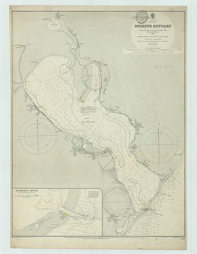
| Title | Dniestr Estuary. Black Sea. 2208. |
| Main title | Mt.: Tsarigrad Mouth. (Tsarigrád (kikötő) bejárat.) |
| Subject | Fekete-tenger: a Dnyeszter torkolat vidékének térképe 1910-ben. |
122. Plans in the Black Sea. 1233 két térk. egy lapon.: 1. Consta... [B II b 96]
Institute and Museum of Military History •
B II b
•
B II Európa, nagyobb részek és országcsoportok
•
B I–XV. Európa
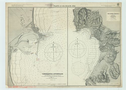
| Title | Plans in the Black Sea. 1233 két térk. egy lapon.: 1. Constantza anchorage. (Kustenjeh.) (Constanţa) |
| Main title | 2. Bender Erekli. (Eregli, Tör.) The Ancient Heraclea. |
| Subject | A Fekete-tenger partvidékének térképe 1911-ben. |
123. Plans in the Black Sea. 2285. Három térkép egy lapon: 1. Bal... [B II b 97]
Institute and Museum of Military History •
B II b
•
B II Európa, nagyobb részek és országcsoportok
•
B I–XV. Európa
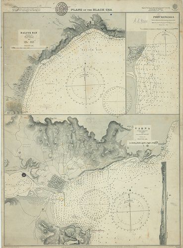
| Title | Plans in the Black Sea. 2285. Három térkép egy lapon: 1. Baljuk Bay, (Balcsik, Bulg.) |
| Main title | 2. Port Mangalia. (Rom.) |
| Subject | 3. Varna. (Várna, Bulg.) |
124. Ports and anchorages on the south shore of the Black Sea. [9... [B II b 98]
Institute and Museum of Military History •
B II b
•
B II Európa, nagyobb részek és országcsoportok
•
B I–XV. Európa
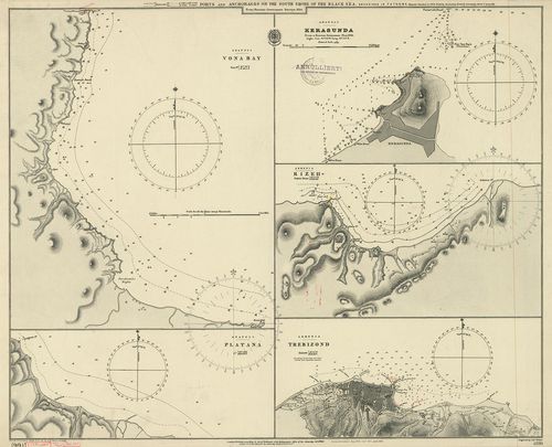
| Title | Ports and anchorages on the south shore of the Black Sea. [991] 2220. 5 térkép egy lapon: 1. Vona Bay. Anatoli. (Anatólia, Tör.) 2. Platana. Anatoli (Tör.] 3. Kerasunda. Anatoli (Giresun, Tör.) |
| Main title | 4. Rizeh. Armenia. (Örményország. Rize.) 5. Trebizond. Armania. (Trabzon, Tör.) |
| Subject | A Fekete-tenger partivékének térképe 1903-ban. |
125. Batum Bay. Black Sea – Georgia. 3303 [B II b 99]
Institute and Museum of Military History •
B II b
•
B II Európa, nagyobb részek és országcsoportok
•
B I–XV. Európa
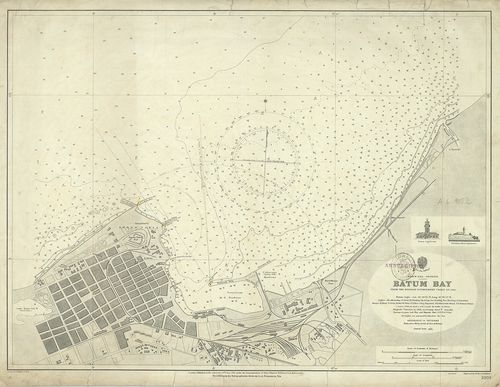
| Title | Batum Bay. Black Sea – Georgia. 3303 |
| Main title | Fekete-tenger partvidék: a Batum-öböl térképe 1911-ben. |
126. Marmara Island and Pasha Liman Group. Sea of Marmara. 2242. [B II b 100]
Institute and Museum of Military History •
B II b
•
B II Európa, nagyobb részek és országcsoportok
•
B I–XV. Európa
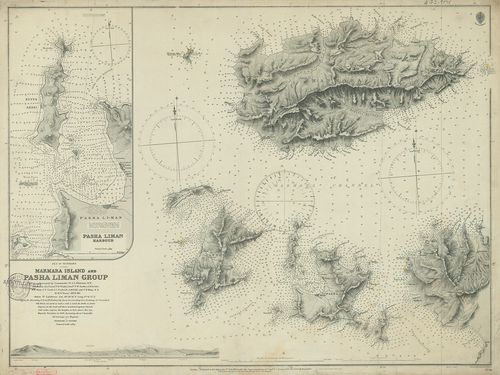
| Title | Marmara Island and Pasha Liman Group. Sea of Marmara. 2242. |
| Main title | Mt.: Pasha Liman Harbour. |
| Subject | (Pasalimani, Tör.) |
127. Plans of Turkish Ports on the South shore of the Black Sea. ... [B II b 101]
Institute and Museum of Military History •
B II b
•
B II Európa, nagyobb részek és országcsoportok
•
B I–XV. Európa
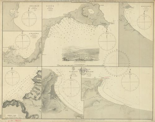
| Title | Plans of Turkish Ports on the South shore of the Black Sea. [993] 2216. 7 térkép egy lapon.: 1. Ak Liman ancient Armene. (Tör.) 2. Amastra Ancient Amastris (Amasra, Tör.) 3. Koslu Bay 1854. (Akcakoca, Tör.) 4. Sinub ancient Sinope (Sinop, Tör.) 5. Samsun ancient Amisus. (Tör.) 6. Unieh ancient Oenoe. (Ünye, Tör.) 7. Gherzeh ancient Carusa, (Gerze, Tör.) |
| Main title | A Fekete-tenger partvidékén a törökországi kikötők térképe 1901-ben. |
128. The Khersonese Bays of Kazach. Kamiesh and Peschana. Black S... [B II b 102]
Institute and Museum of Military History •
B II b
•
B II Európa, nagyobb részek és országcsoportok
•
B I–XV. Európa
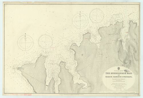
| Title | The Khersonese Bays of Kazach. Kamiesh and Peschana. Black Sea – Krimea. 965 |
| Main title | A Fekete-tenger, a Krím-félsziget partvidéke: a Herszonesz-öböl és környékének térképe 1896-ban. |
129. Hypsometrische Karte der Kriegsschauplätze. [B II b 104]
Institute and Museum of Military History •
B II b
•
B II Európa, nagyobb részek és országcsoportok
•
B I–XV. Európa
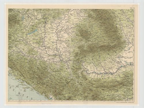
| Title | Hypsometrische Karte der Kriegsschauplätze. |
| Main title | A Steinhauser-féle 1877. évi térkép hipszometrikus reprodukciója a hadszínterekről. |
130. Közép-Európa vasút- és víziútjainak átnézeti gérképe. [B II b 111]
Institute and Museum of Military History •
B II b
•
B II Európa, nagyobb részek és országcsoportok
•
B I–XV. Európa
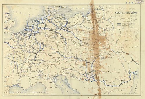
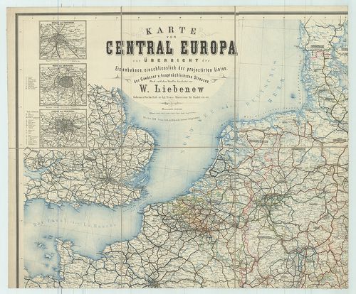
| Title | Közép-Európa vasút- és víziútjainak átnézeti gérképe. |
131. Kriegstheater zwischen Russland und der Ottomanischen Pforte... [B II c 1]
Institute and Museum of Military History •
B II c
•
B II Európa, nagyobb részek és országcsoportok
•
B I–XV. Európa
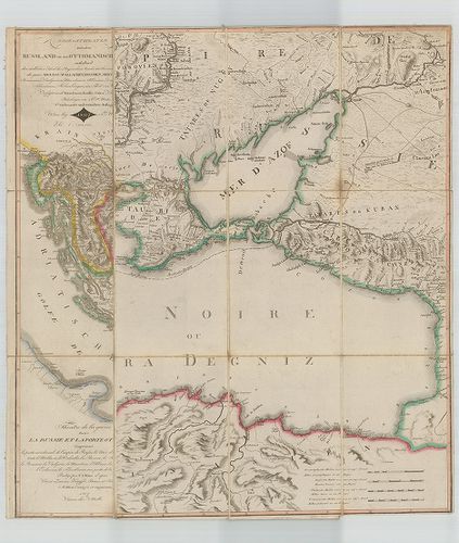
| Title | Kriegstheater zwischen Russland und der Ottomanischen Pforte… Teatre de la guerre entre la Russie et la Porte Ottomane… |
| Main title | Az orosz–török hadszíntér térképe 1807-ben. |
132. Eisenbahnkarte von Deutschland und Österreich-Ungarn. [B II c 2]
Institute and Museum of Military History •
B II c
•
B II Európa, nagyobb részek és országcsoportok
•
B I–XV. Európa
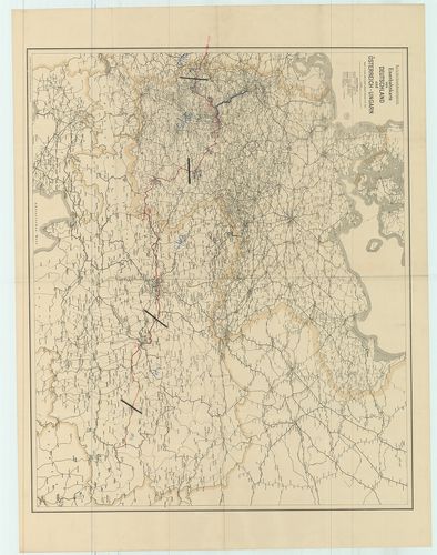
| Title | Eisenbahnkarte von Deutschland und Österreich-Ungarn. |
| Main title | Németország és Ausztria–Magyarország vasúti térképe 1915-ben. |
133. Die Festungen und Haupt-Kommunikazionen Mittel-Europas. [B II c 3]
Institute and Museum of Military History •
B II c
•
B II Európa, nagyobb részek és országcsoportok
•
B I–XV. Európa
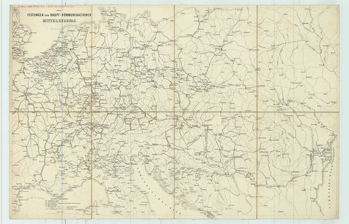
| Title | Die Festungen und Haupt-Kommunikazionen Mittel-Europas. |
| Main title | Közép-Európa erődei és közlekedési térképe 1859-ben. |
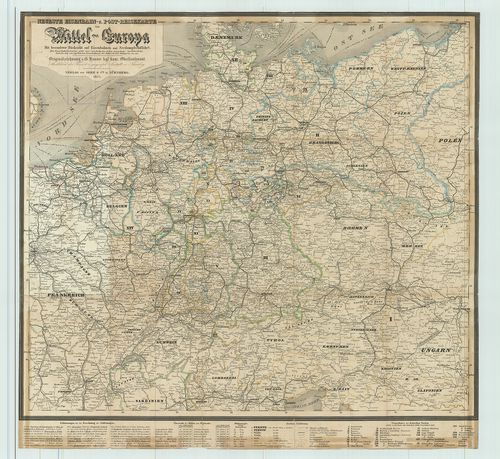
134. Neuste Eisenbahn-Karte von Central-Europa mit genauer Angabe... [B II c 4]
Institute and Museum of Military History •
B II c
•
B II Európa, nagyobb részek és országcsoportok
•
B I–XV. Európa
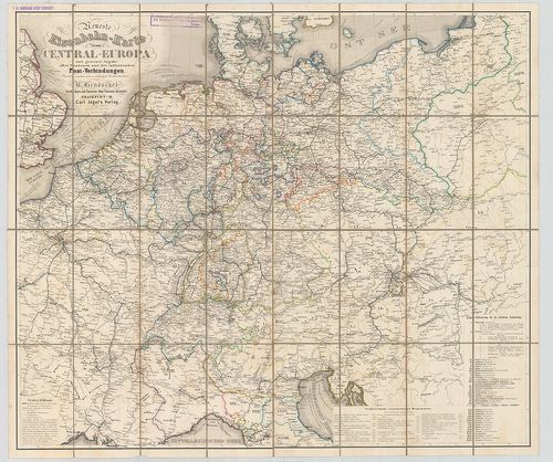
| Title | Neuste Eisenbahn-Karte von Central-Europa mit genauer Angabe aller Stationen und der influirenden Post-Verbindungen. |
| Main title | Közép-Európa postai összeköttetéseinek térképe. |
135. Eisenbahn-Karte von Mittel-Europa… [B II c 5]
Institute and Museum of Military History •
B II c
•
B II Európa, nagyobb részek és országcsoportok
•
B I–XV. Európa
| Title | Eisenbahn-Karte von Mittel-Europa… |
| Main title | 5 mt.: 1. Rheinisch-Westfälisches Industrie-Gebiet. (Rajna-Westfália iparvidék.) 2. O.-Schlesisches Industriegebiet. (Felső-Szilézia iparvidéke) 3. Harz-Gebiet. (Harz-vidék.) 4. [Frankfurt-Karlsruhe közötti terület.] 5. Königreich Sachsen. (Szászország.) |
| Subject | Közép-Európa vasúti térképe. |
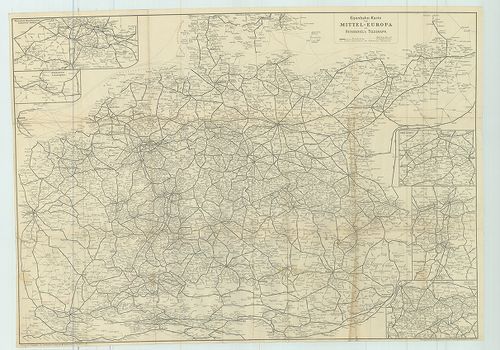
136. Karte von Central Europa zur Übersicht der Eisenbahnen einsc... [B II c 6]
Institute and Museum of Military History •
B II c
•
B II Európa, nagyobb részek és országcsoportok
•
B I–XV. Európa
| Title | Karte von Central Europa zur Übersicht der Eisenbahnen einschliesslich der projectirten Linien, der Gewässer u. hauptsächlichsten Strassen. |
| Main title | 6 mt.: 1. Berlin u. Umgegend. |
| Subject | (Berlin és környéke). 2. Paris u. Umgegend. |
137. Reise- und übersichts-Karte von Deutschland nebst den angrän... [B II c 7]
Institute and Museum of Military History •
B II c
•
B II Európa, nagyobb részek és országcsoportok
•
B I–XV. Európa
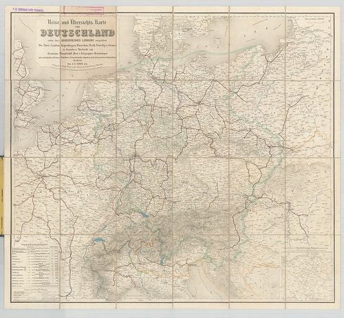
| Title | Reise- und übersichts-Karte von Deutschland nebst den angränzenden Ländern, ausgedehnt bis Paris, Longon, Kopenhagen, Warschau, Pest, Venedig u. Genue in besonderer Rücksicht auf Eisenbahn, Dampfschiff Post- u. Telegraphen-Verbindungen… |
| Main title | Mt.: Uebersichts-Karte der Haupt Entfernungen (Distanzen)… Telegraphen u. Eisenbahn-Netz… |
| Subject | Közép-Európa: Németország és a környező országok áttekintő és úttérképe 1855-ben. |
138. Eisenbahnkarte [von Mitteleurope.] [B II c 8]
Institute and Museum of Military History •
B II c
•
B II Európa, nagyobb részek és országcsoportok
•
B I–XV. Európa
| Title | Eisenbahnkarte [von Mitteleurope.] |
| Main title | 15 mt. vasútforgalmi térképek. |
| Subject | Közép-Európa vasúttérképe a 20. század elején. |
139. Eisenbahn-Karte des östlichen Europa [B II c 10]
Institute and Museum of Military History •
B II c
•
B II Európa, nagyobb részek és országcsoportok
•
B I–XV. Európa
| Title | Eisenbahn-Karte des östlichen Europa |
| Main title | Kelet-Európa vasúttérképe 1875 körül. |
140. Neueste Eisenbahn-und Post-Reisekarte von Mittel-Europa. [B II c 11]
Institute and Museum of Military History •
B II c
•
B II Európa, nagyobb részek és országcsoportok
•
B I–XV. Európa
| Title | Neueste Eisenbahn-und Post-Reisekarte von Mittel-Europa. |
| Main title | Közép-Európa vasút-, posta- és úttérképe 1855-ben. |