2121. Uebersichts-Karte der Ostalpen, westliches Blatt. [B IX b 65]
Institute and Museum of Military History •
B IX b
•
B IX Ausztria–Magyarország
•
B I–XV. Európa
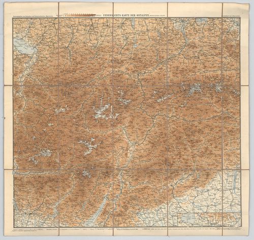
| Title | Uebersichts-Karte der Ostalpen, westliches Blatt. |
| Main title | A Keleti-Alpok nyugati részének áttekintő térképe 1892-ben. |
2122. Uebersichts-Karte der Ostalpen, westliches Blatt. (Neue-Ausg... [B IX b 65/1]
Institute and Museum of Military History •
B IX b
•
B IX Ausztria–Magyarország
•
B I–XV. Európa
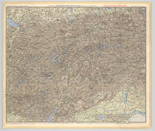
| Title | Uebersichts-Karte der Ostalpen, westliches Blatt. (Neue-Ausgabe 1900) |
| Main title | A Keleti-Alpok nyugati részének áttekintő térképe 1900-ban. |
2123. Karte der Adamello – und Presanella – Gruppe. [B IX b 69/1]
Institute and Museum of Military History •
B IX b
•
B IX Ausztria–Magyarország
•
B I–XV. Európa
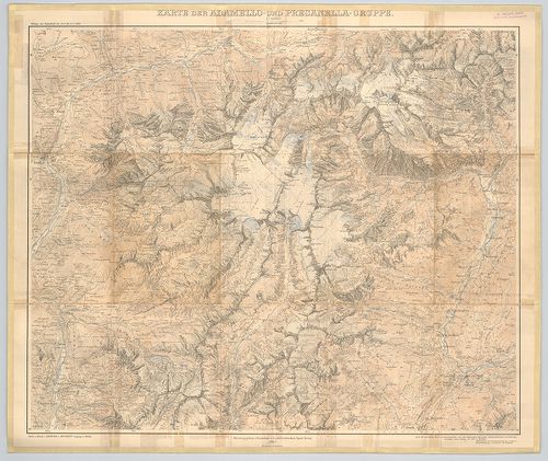
| Title | Karte der Adamello – und Presanella – Gruppe. |
| Main title | Az Adamello és Presanella hegycsoportok (Ol.) térképe 1903-ban. |
2124. Karte der Langkofel- und Sellagruppe. [B IX b 70/5]
Institute and Museum of Military History •
B IX b
•
B IX Ausztria–Magyarország
•
B I–XV. Európa
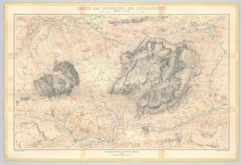
| Title | Karte der Langkofel- und Sellagruppe. |
| Main title | A Langkofel és a Sella hegycsoport (Ol.) térképe 1904-ben. |
2125. Panorama vom Rittner-Horn nächst Bozen-Tirol. [B IX b 71]
Institute and Museum of Military History •
B IX b
•
B IX Ausztria–Magyarország
•
B I–XV. Európa
| Title | Panorama vom Rittner-Horn nächst Bozen-Tirol. |
| Main title | A Rittner-Horn hegység (Au.–Ol.) panoráma képe 1920 körül. |
2126. Das Semmeringgebiet mit Rax und Schneeberg. [B IX b 72/2]
Institute and Museum of Military History •
B IX b
•
B IX Ausztria–Magyarország
•
B I–XV. Európa
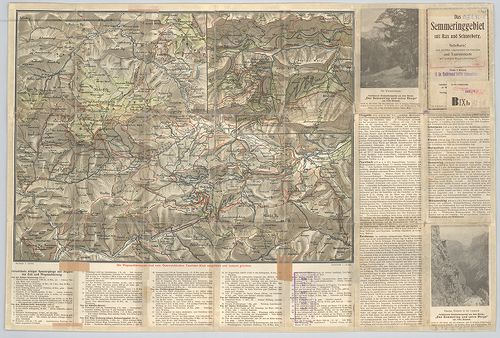
| Title | Das Semmeringgebiet mit Rax und Schneeberg. |
| Main title | Hátlapon: [A Semmering és a Schneeberg hegységek turistaútjai.] |
| Subject | Mt. [A Semmering turistaútjai.] |
2127. Übersichtskarte der Dolomiten. [B IX b 72/7]
Institute and Museum of Military History •
B IX b
•
B IX Ausztria–Magyarország
•
B I–XV. Európa
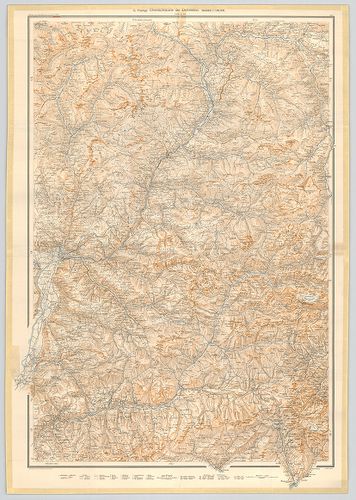
| Title | Übersichtskarte der Dolomiten. |
| Main title | A Dolomitok hegyrajzi áttekintő térképe 1903-ban. |
2128. Karte des Riesen-Gebirgs. [B IX b 77]
Institute and Museum of Military History •
B IX b
•
B IX Ausztria–Magyarország
•
B I–XV. Európa
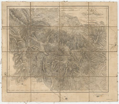
| Title | Karte des Riesen-Gebirgs. |
| Main title | A Karkonosze (Riesen-Gebirgs) hegység térképe 1806-ban. |
2129. Situation und Längenprofil der dammherstellung im Laibacher ... [B IX b 78]
Institute and Museum of Military History •
B IX b
•
B IX Ausztria–Magyarország
•
B I–XV. Európa
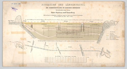
| Title | Situation und Längenprofil der dammherstellung im Laibacher Moorboden. |
| Main title | A ljubljanai lápos talaj gáthelyreállítási helyzetképe és hosszanti keresztmetszete 1855–1856-ban. (Vasútépítési munkálatokhoz.) |
2130. Karte der Ost-Alpen. [B IX b 79]
Institute and Museum of Military History •
B IX b
•
B IX Ausztria–Magyarország
•
B I–XV. Európa
| Title | Karte der Ost-Alpen. |
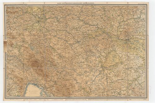
| Main title | Blatt: 1. Karte der Bayerischen u. Algäuer-Alpen. 2. Karte der Salzburger Alpen u. des Salzkammergutes. 3. Karte des Oesterreichischen Alpen u. des Winer-Waldes. 4. Karte der West-Tiroler u. Engadiner-Alpen. 5. Karte der Ost-Tiroler Alpen, Tauern- u. Dolomiten. 6. Karte der Steierischen Alpen u. der Karawanken. 7. Karte der Lombardischen u. Süd-Tiroler Alpen. 8. Karte der Südvenetianischen Alpen u. Karst. 9. Karte des Krainisch-Kroatischen Gebirgs Landes. |
| Subject | Az Alpok keleti részének hipszometrikus térképe 1880–1893-ban. |
2131. Karte Boszne i Hercegovine. [B IX b 80/1]
Institute and Museum of Military History •
B IX b
•
B IX Ausztria–Magyarország
•
B I–XV. Európa
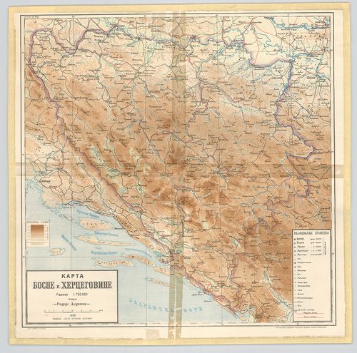
| Title | Karte Boszne i Hercegovine. |
| Main title | Bosznia és Hercegovina hegyvízrajzi térképe 1909-ben. |
2132. Hydrographische Karte der oestereichischen Erbstaaten diesse... [B IX b 81]
Institute and Museum of Military History •
B IX b
•
B IX Ausztria–Magyarország
•
B I–XV. Európa
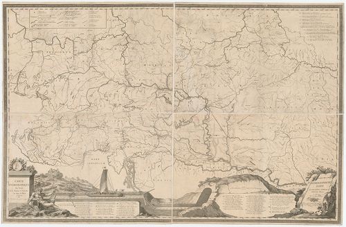
| Title | Hydrographische Karte der oestereichischen Erbstaaten diesseits des Rheins. – Carte hydrographique des Etats de la Maison d’Autriche en deca du Rhin. |
| Main title | Csatornatervek. I. Jonction de la mer Adriatique á la Culpa-Verbindung des Adriatischen Meeres mit der Kulpa. (Az Adriai-tenger összeköttetése a Kulpa folyóval.) |
| Subject | II. Jonction de la Drave a la Save-Verbindung der Drau mit der Sau. (A Dráva és Száva összeköttetése.) |
2133. Hydrographische Uibersichtskarte der Flüsse, Bäche und sonst... [B IX b 83]
Institute and Museum of Military History •
B IX b
•
B IX Ausztria–Magyarország
•
B I–XV. Európa
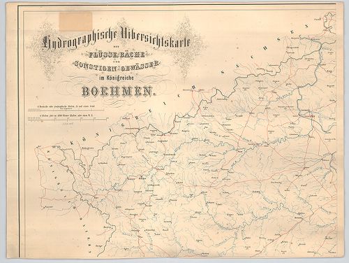
| Title | Hydrographische Uibersichtskarte der Flüsse, Bäche und sonstigen gewässer im Königreiche Boehmen. |
| Main title | Csehország áttekintő vízrajzi térképe. |
2134. A verseczi hegység magassági rétegeinek térképe. [B IX b 85]
Institute and Museum of Military History •
B IX b
•
B IX Ausztria–Magyarország
•
B I–XV. Európa
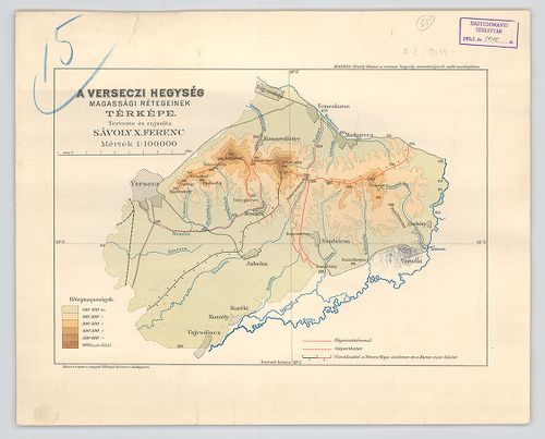
| Title | A verseczi hegység magassági rétegeinek térképe. |
2135. A Gömör megyei Hradek és környékének geológiai térképe. [B IX b 87]
Institute and Museum of Military History •
B IX b
•
B IX Ausztria–Magyarország
•
B I–XV. Európa
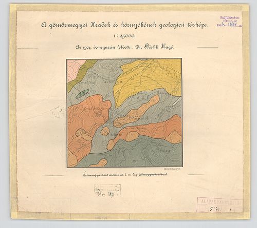
| Title | A Gömör megyei Hradek és környékének geológiai térképe. |
2136. Karte der Slawonischen Drau Donak Ebene mit dem Canalisation... [B IX b 91]
Institute and Museum of Military History •
B IX b
•
B IX Ausztria–Magyarország
•
B I–XV. Európa
| Title | Karte der Slawonischen Drau Donak Ebene mit dem Canalisations Projekte des Vuka- und der Darstellung einer möglichen Canalisirung des Karasica-Fluss Gebiethes. |
| Main title | Mt.: Situation der Canal Projecte. (A csatornatervezet helyzete.) |
| Subject | A szlavóniai Dráva térképe a 19. században, csatornázási tervek. |
2137. [A Duna vízgyűjtője a német-osztrák határtól a torkolatig. M... [B IX b 93]
Institute and Museum of Military History •
B IX b
•
B IX Ausztria–Magyarország
•
B I–XV. Európa
| Title | [A Duna vízgyűjtője a német-osztrák határtól a torkolatig. Magassági pontok, egyéb megírás nélkül.] |
2138. Carta idrografica del golfo di Trieste. … [B IX b 94]
Institute and Museum of Military History •
B IX b
•
B IX Ausztria–Magyarország
•
B I–XV. Európa
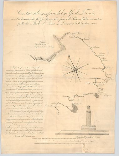
| Title | Carta idrografica del golfo di Trieste. … |
| Main title | A Trieszti-öböl vízrajzi térképe 1832 körül. |
2139. Piano della rada di Trieste. [B IX b 94/1]
Institute and Museum of Military History •
B IX b
•
B IX Ausztria–Magyarország
•
B I–XV. Európa
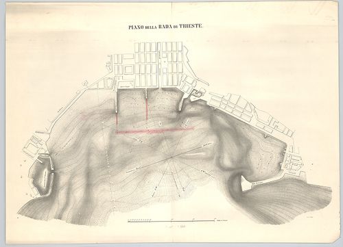
| Title | Piano della rada di Trieste. |
| Main title | Az új trieszti kikötő tervrajza 1867 körül. |
2140. Golf von Fiume. [B IX b 95]
Institute and Museum of Military History •
B IX b
•
B IX Ausztria–Magyarország
•
B I–XV. Európa
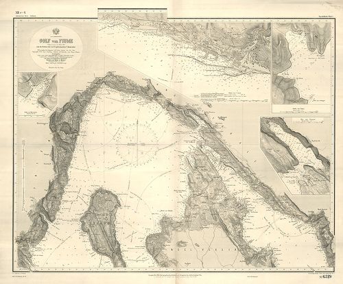
| Title | Golf von Fiume. |
| Main title | 4 mt. 1 Hafen von Martinšćica. (Martinšćici-öböl.) 2. Hafen von Fiume. (Fiumei-öböl.) 3. Hafen von Rabaz. (Rabazi-öböl.) 4. Bai von Buccari. (Buccari-öböl.) |
| Subject | A Fiumei-öböl térképe az 1867-es állapotoknak megfelelően. |