521. Lauf des Neckers von Heilbronn bis Mannheim. [B IV b 101]
Institute and Museum of Military History •
B IV b
•
B IV Német birodalom
•
B I–XV. Európa
| Title | Lauf des Neckers von Heilbronn bis Mannheim. |
522. Carte des Pays Yougoslaves. [B III a 237]
Institute and Museum of Military History •
B III a
•
B III Balkán-félsziget
•
B I–XV. Európa
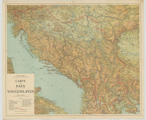
| Title | Carte des Pays Yougoslaves. |
| Main title | Jugoszlávia térképe. |
523. Mappe des Hotters S[ank]t Martin [TK 1025]
National Széchényi Library •
OSZK kéziratos térképek

| Title | Mappe des Hotters S[ank]t Martin |
524. Renvoy du plan des lignes de Lauterbourg [TK 1334]
National Széchényi Library •
OSZK kéziratos térképek

| Title | Renvoy du plan des lignes de Lauterbourg |
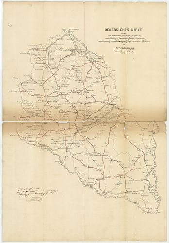
525. Uebersichts Karte der mit dem Gouvernement Erlasse ddto 9. J... [S 101 - No. 536.]
National Archives of Hungary •
S 101 Abszolutizmuskori térképek (1849-1867)
•
S Kormányhatósági fondokból kiemelt térképek (17. sz.-20. sz.)
•
S – Térképtár
| Main title | Uebersichts Karte der mit dem Gouvernement Erlasse ddto 9. Juny 1854, Z 3909/119 in die Erhaltung des Landesbaufondes übernommen, nebst Bezeichnung der in Staatsartiger Pflege stehenden Strassen des Oedenburger Verwaltungs Gebiethes |
| Subject | No. 536. A soproni közigazgatási kerület |
526. Hydrotechnische Flusz Karte des Flusses Nagy-Ág bei Huszt in... [S 12 - Div. XIII. - No. 665.]
National Archives of Hungary •
S 12 Helytartótanácsi térképek (1738-1875)
•
S Kormányhatósági fondokból kiemelt térképek (17. sz.-20. sz.)
•
S – Térképtár
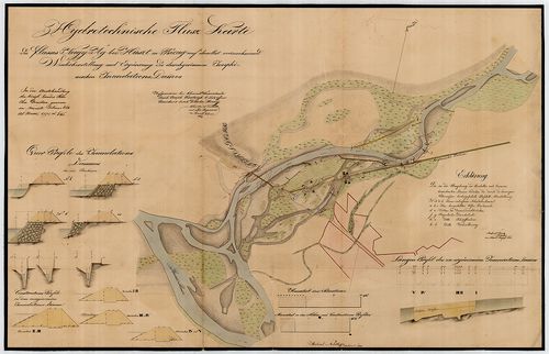
| Main title | Hydrotechnische Flusz Karte des Flusses Nagy-Ág bei Huszt in Bezug auf dasselbst vorzunehmende Wiederherstellung und Ergänzung des durchgerissenen Josephinischen Inundations-Dammes |
| Subject | Div. XIII. - No. 665. A Nagyág folyó Huszt /Máramaros m./ melletti szakaszának szabályozási és gát térképe |
527. Plan von einem Theil des Donau-Stroms von ober Altofen bis z... [S 12 - Div. XIII. - No. 378:3-4.]
National Archives of Hungary •
S 12 Helytartótanácsi térképek (1738-1875)
•
S Kormányhatósági fondokból kiemelt térképek (17. sz.-20. sz.)
•
S – Térképtár
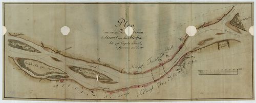
| Main title | Plan von einem Theil des Donau-Stroms von ober Altofen bis zur Csepeler Insel; Sondirungs Profil des Donau Flusses zwischen Ofen und Pest |
| Subject | Div. XIII. - No. 378:3-4. A Duna az Óbudai- és a Csepel-sziget között |
528. Uibersichts Karte der Laengen und Querprofile des neu projec... [S 101 - No. 892.]
National Archives of Hungary •
S 101 Abszolutizmuskori térképek (1849-1867)
•
S Kormányhatósági fondokból kiemelt térképek (17. sz.-20. sz.)
•
S – Térképtár
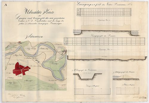
| Main title | Uibersichts Karte der Laengen und Querprofile des neu projectirten Csekeer No. 2. Durchstiches und des längs desselben zu erbauenden linkufrigen Dammzuges |
| Subject | No. 892. A Tisza folyó Szatmárcseke (Szatmár m., ma Szabolcs-Szatmár-Bereg m.) mellett, a tervezett átvágásokkal |
529. Declaration des commissaires des principales puissances alli... [S 15 - Lad. VV. 2. - Fasc. 1. - No. 5.]
National Archives of Hungary •
S 15 Regnicolaris levéltár térképei (1754-1925)
•
S Kormányhatósági fondokból kiemelt térképek (17. sz.-20. sz.)
•
S – Térképtár
| Main title | Declaration des commissaires des principales puissances alliees [et] associees au sujet de la protestation inseree au process-verbal definitif de delimitation par le commissaire de la Hongrie |
| Subject | Lad. VV. 2. - Fasc. 1. - No. 5. Magyarország és Románia határa |
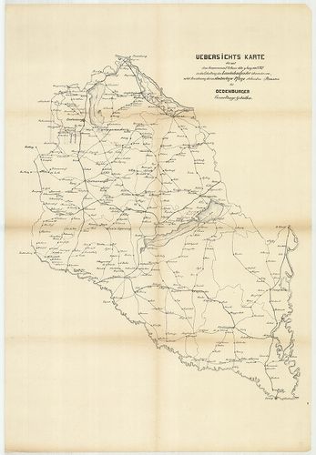
530. Uebersichts Karte der mit dem Gouvernement Erlasse ddto 9. J... [S 101 - No. 514.]
National Archives of Hungary •
S 101 Abszolutizmuskori térképek (1849-1867)
•
S Kormányhatósági fondokból kiemelt térképek (17. sz.-20. sz.)
•
S – Térképtár
| Main title | Uebersichts Karte der mit dem Gouvernement Erlasse ddto 9. Juny 1854, Z 3909/119 in die Erhaltung des Landesbaufondes übernommen, nebst Bezeichnung der in Staatsartiger Pflege stehenden Strassen des Oedenburger Verwaltungs Gebiethes |
| Subject | No. 514. A soproni közigazgatási kerület |
531. Situations Plan des Baches so bei der Papier Mühl des Maria ... [S 12 - Div. XIII. - No. 75.]
National Archives of Hungary •
S 12 Helytartótanácsi térképek (1738-1875)
•
S Kormányhatósági fondokból kiemelt térképek (17. sz.-20. sz.)
•
S – Térképtár
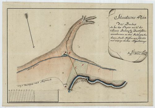
| Main title | Situations Plan des Baches so bei der Papier Mühl des Maria Bedreczky Bartfelder Einwohnerin in dem Mühlgraben deren Stadt Mühlen einflüsset ... |
| Subject | Div. XIII. - No. 75. A Tapoly Bartfelder /Bártfa - Sáros m./ melletti szakaszának és a malomároknak vízrajzi térképe |
532. A körmöczi bányavidék földtani viszonyai bányageológiai szem... [B IX b 22/6]
Institute and Museum of Military History •
B IX b
•
B IX Ausztria–Magyarország
•
B I–XV. Európa
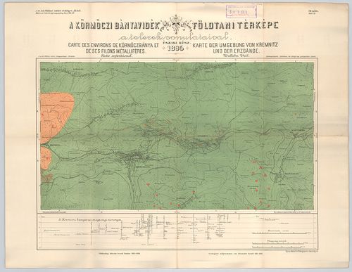
| Title | A körmöczi bányavidék földtani viszonyai bányageológiai szempontból. – Die Geologischen verhältnisse des Kremnitzer Bergbaugebietes von Montangeologischen standpunkte. XI. köt. 4. füz. Atlasz. |
| Main title | 2 térk. mell. 1. VII. tábl. A körmöczi bányavidék földtani térképe a telerek vonulataival. É-i rész 1895. – Carte des environs de Körmöczbánya et de ses filons métalliféres. Partie septentrional. Karte des Umgebung von Kremnitz und der Erzgänge. Nördlicher Theil. |
| Subject | 2. VIII. tábla. A körmöczi bányavidék földtani térképe a Nándor altáró kitüntetésével. Déli rész 1895. – Carte des environs de Körmöczbánya avec la galérie d’ecoulement nommée galérie Nándor. Partie meridionale 1895. – Karte der Umgebung von Kremnitz mit dem Ferdinand erbstollen. Südlicher Theil 1895. |
533. Carte Générale des Postes du Royaume de Hongrie y Compris la... [B IX c 42]
Institute and Museum of Military History •
B IX c
•
B IX Ausztria–Magyarország
•
B I–XV. Európa
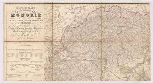
| Title | Carte Générale des Postes du Royaume de Hongrie y Compris la Transylvanie l’Esclavonie, la Croatie avec une Partie des Provinces de Galicie, Moravie, Autriche, Illyrie etc. – Post und Generalcharte des Königreiches Ungarn mit Einschluss von Siebenbürgen, Slavonien und Croatien und den angränzenden Theilen von Osterreich, Mähren, Galizien, Moldau u. s. w. |
| Main title | A Magyar Királyság, Erdély, Horvát-Szlavonia és a határos osztrák, morva, galíciai, moldva, stb. részek posta- és általános térképe 1848-ban. |
534. Plan des Donau Stroms von Ausflus des Mohatser Donau Arms be... [S 12 - Div. XI. - No. 6.]
National Archives of Hungary •
S 12 Helytartótanácsi térképek (1738-1875)
•
S Kormányhatósági fondokból kiemelt térképek (17. sz.-20. sz.)
•
S – Térképtár
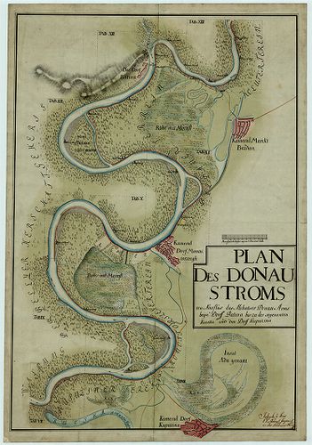
| Main title | Plan des Donau Stroms von Ausflus des Mohatser Donau Arms beyn Dorff Batina bis zu der sogenannten Kutska und den Dorff Kupuzina |
| Subject | Div. XI. - No. 6. A Duna Kiskőszeg (Baranya m., ma Batina, HR) és Kupuszina (Bács m.) között |
535. Plan über die Verlängerung der im Jahre 1827 zur Bildung des... [S 12 - Div. XIII. - No. 590.]
National Archives of Hungary •
S 12 Helytartótanácsi térképek (1738-1875)
•
S Kormányhatósági fondokból kiemelt térképek (17. sz.-20. sz.)
•
S – Térképtár
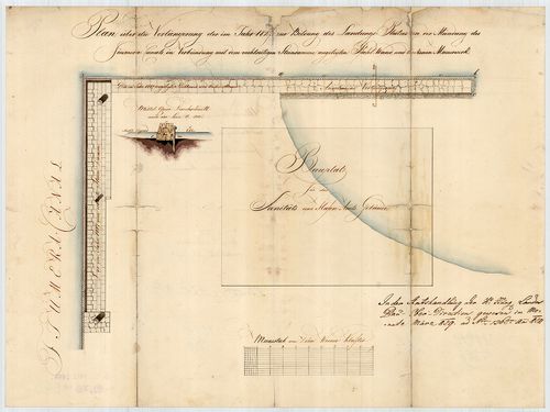
| Main title | Plan über die Verlängerung der im Jahre 1827 zur Bildung des Landungs-Platzes an der Mündung des Fiumera-Canals in Verbindung mit dem rechtseitigen Steindamme, angelegten Pfahl-Wand und trockenen Mauerwerke |
| Subject | Div. XIII. - No. 590. Fiume épülő kikötőrészének térképe |
536. Aufnahms Plan der hergestellten Umfangs Mauer bei dem Garten... [S 101 - No. 48.]
National Archives of Hungary •
S 101 Abszolutizmuskori térképek (1849-1867)
•
S Kormányhatósági fondokból kiemelt térképek (17. sz.-20. sz.)
•
S – Térképtár
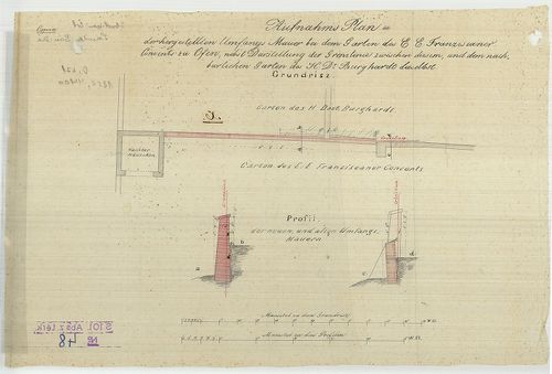
| Main title | Aufnahms Plan der hergestellten Umfangs Mauer bei dem Garten des E. E. Franziscaner Convents zu Ofen nebst Darstellung der Grenzlinie zwischen diesem und dem Nachbarlichen Garten des H. Dr. Burghardt daselbst |
| Subject | No. 48. A budai ferences kolostor újjáépített kertfala |
537. Übersichtskarte des russisch-japanischen Kriegsschauplatzes ... [H IV c 357]
Institute and Museum of Military History •
H IV c (1841–1913)
•
H IV Újabbkori háborúk
•
H Háborúk

| Title | Übersichtskarte des russisch-japanischen Kriegsschauplatzes [1904] |
| Main title | 2 mt.: 1. Skizze der Baikal-Güntelbahn. (A Bajkál-vasút) 2. Ein Theil des Deutschen Reiches im Massstab der hauptkarte. (Észak-Németország, hasonlító vázl. a főtérk.-hez.)Az orosz–japán háború színterének áttekintő térképe. |
538. Karte und Pläne zu der Geschichte des Feldzugs vom Jahr 1799... [H IV a 761]
Institute and Museum of Military History •
H IV a (1700–1820)
•
H IV Újabbkori háborúk
•
H Háborúk
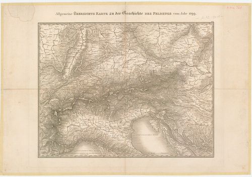
| Title | Karte und Pläne zu der Geschichte des Feldzugs vom Jahr 1799 in Deutschland und in der Schweiz. |
| Main title | 1. Allgemeine Übersichts Karte zu der Geschlichte des Feldzugs vom Jahr 1799. |
| Subject | 2. Gefecht bey Feldkirch (Au.) am 23-ten März 1799. |
539. Le Bannat de temeschear d'apres les nouvelles indications, p... [S 68 - X. - No. 99.]
National Archives of Hungary •
S 68 Festetics család (1645-1943)
•
S Családi fondokból kiemelt térképek (17. sz.-20. sz.)
•
S – Térképtár
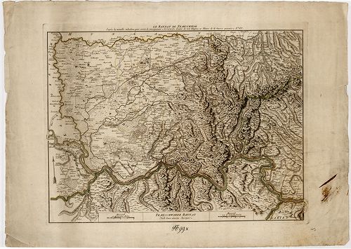
| Main title | Le Bannat de temeschear d'apres les nouvelles indications, pour servir de renseignement a la carte des limites des trois empires, ou theatre de la guerre presente 1789; Temeschwarer Bannat nach denen neuesten Anzeigen |
| Subject | X. - No. 99. Temesi Bánság |
540. Carta topografica dello Stato Pontificio e del Gran-Ducato d... [B VII a 385]
Institute and Museum of Military History •
B VII a
•
B VII Olaszország
•
B I–XV. Európa
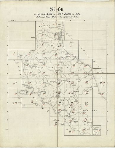
| Title | Carta topografica dello Stato Pontificio e del Gran-Ducato di Toscana construtta sopra misure astronomico trigonometriche ed incisa sopra pietra… Topographische Karte des Kirchenstaates und des Grossherzogthunes Toscana… |
| Main title | Az Egyházi Állam és a Toscana-i Nagyhercegség topográfiai térképe 1851-ben. |