61. Geologische Karte von Österreich–Ungarn… [B IX b 21]
Institute and Museum of Military History •
B IX b
•
B IX Ausztria–Magyarország
•
B I–XV. Európa
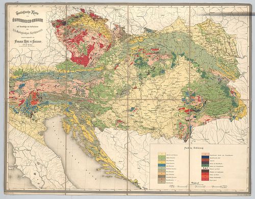
| Title | Geologische Karte von Österreich–Ungarn… |
| Main title | Ausztria–Magyarország geológiai térképe. |
62. Strassen-Karte des Koenigreiches Ungarn. [B IX c 619]
Institute and Museum of Military History •
B IX c
•
B IX Ausztria–Magyarország
•
B I–XV. Európa
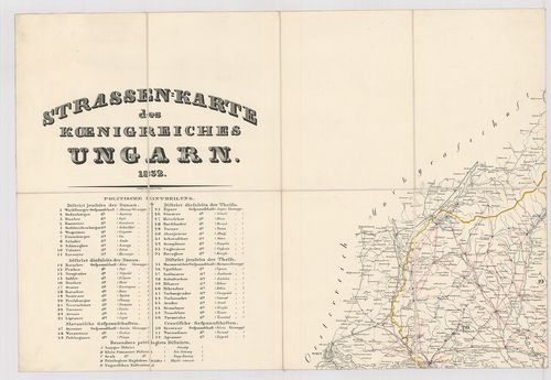
| Title | Strassen-Karte des Koenigreiches Ungarn. |
| Main title | Magyarország úttérképe 1832-ben. |
63. Österreich-Ungarn. Übersicht. [B IX a 1141]
Institute and Museum of Military History •
B IX a
•
B IX Ausztria–Magyarország
•
B I–XV. Európa
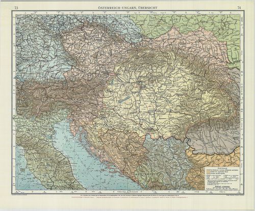
| Title | Österreich-Ungarn. Übersicht. |
| Main title | Az Osztrák-Magyar Monarchia áttekintő térképe. |
64. Österreich-Ungarn. [B IX a 1148]
Institute and Museum of Military History •
B IX a
•
B IX Ausztria–Magyarország
•
B I–XV. Európa
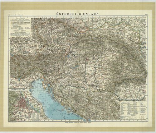
| Title | Österreich-Ungarn. |
| Main title | Az Osztrák-Magyar Monarchia térképe 1912-ből. |
65. Grundriss der Haubt-residenz und Krőnungs-Statt Presburg in ... [TK 470]
National Széchényi Library •
OSZK kéziratos térképek
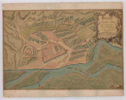
| Title | Grundriss der Haubt-residenz und Krőnungs-Statt Presburg in ober Ungarn |
66. Ethnographische Karte des Königreichs Ungarn. [B IX c 118/1]
Institute and Museum of Military History •
B IX c
•
B IX Ausztria–Magyarország
•
B I–XV. Európa
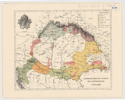
| Title | Ethnographische Karte des Königreichs Ungarn. |
| Main title | Magyarország néprajzi térképe 1846 körül. |
67. Dorf Windischdorf in Ungarn Oedenburg Distrikt Eisenburger C... [VAML T 73 NSZ=nem szkennelt]
Vas County Archives •
Törzsanyag
•
Vas megye kéziratos térképei
| Main title | Dorf Windischdorf in Ungarn Oedenburg Distrikt Eisenburger Comitat |
| Subject | Rábatótfalu |
68. Eisenbahn- und Post-Communications Karte von Oesterreich–Ung... [B IX c 16/2]
Institute and Museum of Military History •
B IX c
•
B IX Ausztria–Magyarország
•
B I–XV. Európa
| Title | Eisenbahn- und Post-Communications Karte von Oesterreich–Ungarn. 1898. Artaria’s |
69. Dorf Permise in Ungarn, Oedenburger Distrikt Eisenburger Com... [VAML T 76 NSZ]
Vas County Archives •
Törzsanyag
•
Vas megye kéziratos térképei
| Main title | Dorf Permise in Ungarn, Oedenburger Distrikt Eisenburger Comitat |
| Subject | Kétvölgy |
70. Gemeinde Hidegkút in Ungarn Ofen-pesther District [Budapest térképeinek katalógusa 2292]
Budapest City Archives •
Peremtelepülések
•
Az 1873 előtti időszakra vonatkozó térképek leírása
•
Budapest térképeinek katalógusa
| Main title | Gemeinde Hidegkút in Ungarn Ofen-pesther District |
| Subject | Pesthidegkút birtokvázlata |
71. Bereiche der Feldtransportleitungen in Österreich–Ungarn und... [B IX c 809]
Institute and Museum of Military History •
B IX c
•
B IX Ausztria–Magyarország
•
B I–XV. Európa
| Title | Bereiche der Feldtransportleitungen in Österreich–Ungarn und der anschliessenden deutschen Linienkommandanturen. |
72. Gemeinde Szentlőrinczi in Ungarn Ofen Pesther District [Budapest térképeinek katalógusa 2295]
Budapest City Archives •
Peremtelepülések
•
Az 1873 előtti időszakra vonatkozó térképek leírása
•
Budapest térképeinek katalógusa
| Main title | Gemeinde Szentlőrinczi in Ungarn Ofen Pesther District |
| Subject | Pestszentlőrinc birtokvázlata |
73. Autokarte von Ungarn. [B XV c 248]
Institute and Museum of Military History •
B XV c
•
B XV Magyarország (1920 után)
•
B I–XV. Európa
| Title | Autokarte von Ungarn. |
| Main title | 2 mt.: 1. Balaton. |
| Subject | 2. Budapest. |
74. General Karte des Erzherzogthums Oesterreich ob und unter de... [S 68 - IX. - No. 88/1-2.]
National Archives of Hungary •
S 68 Festetics család (1645-1943)
•
S Családi fondokból kiemelt térképek (17. sz.-20. sz.)
•
S – Térképtár
| Main title | General Karte des Erzherzogthums Oesterreich ob und unter der Enns |
| Subject | IX. - No. 88/1-2. Ausztria |
Content: [...] Steyermarkt Böhmen Bohémia Maehren Morvao Ungarn számos megnevezett helység pillacsíkkal nevekkel [...] Content: [...] Steyermarkt Böhmen Bohémia Maehren Morvao Ungarn számos megnevezett helység pillacsíkkal nevekkel [...]
75. Industrie- und Communicationskarte des Herzogthumes Bukovina [S 75 - No. 21.]
National Archives of Hungary •
S 75 Nyomtatott térképek (19. sz.-20. sz.)
•
S – Térképtár
| Main title | Industrie- und Communicationskarte des Herzogthumes Bukovina |
| Subject | No. 21. Bukovina ipari és közlekedés-térképe |
Content: É országhatárok Russland Moldau Ungarn Siebenbürgen Galiziien közigazgatási körzethatárok számos [...] Content: É országhatárok Russland Moldau Ungarn Siebenbürgen Galiziien közigazgatási körzethatárok számos [...]
76. Dorf Sachsenfeld in Ungarn Ofen Pesther District [Budapest térképeinek katalógusa 2220]
Budapest City Archives •
Peremtelepülések
•
Az 1873 előtti időszakra vonatkozó térképek leírása
•
Budapest térképeinek katalógusa
| Main title | Dorf Sachsenfeld in Ungarn Ofen Pesther District |
| Subject | Albertfalva kataszteri térképe |
77. Schidau ungarisch Zsidó in Ungarn Oedenburger Distrikt Eisen... [VAML T 74 NSZ]
Vas County Archives •
Törzsanyag
•
Vas megye kéziratos térképei
| Main title | Schidau ungarisch Zsidó in Ungarn Oedenburger Distrikt Eisenburger Comitat |
| Subject | Szentgotthárd |
78. Eisenbahnkarte von Österreich–Ungarn. [B IX c 21/1]
Institute and Museum of Military History •
B IX c
•
B IX Ausztria–Magyarország
•
B I–XV. Európa
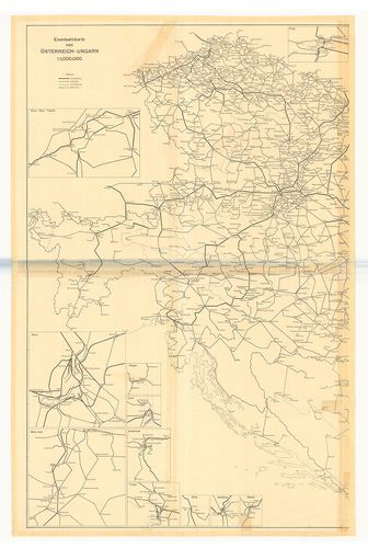
| Title | Eisenbahnkarte von Österreich–Ungarn. |
| Main title | Az Osztrák–Magyar Monarchia vasúttérképe 1914-ben. |
79. Aufnahmskarte des Königreiches Ungarn. [B IX a 530]
Institute and Museum of Military History •
B IX a
•
B IX Ausztria–Magyarország
•
B I–XV. Európa
| Title | Aufnahmskarte des Königreiches Ungarn. |
| Main title | A II. katonai felmérés szelvényei egyszínű másolatban. |
80. Catastral Gemeinde Szentlőrinczi in Ungarn Ofen Pesther Dist... [Budapest térképeinek katalógusa 4175]
Budapest City Archives •
Peremtelepülések
•
Az 1873–1949 közötti időszakra vonatkozó térképek leírása
•
Budapest térképeinek katalógusa
| Main title | Catastral Gemeinde Szentlőrinczi in Ungarn Ofen Pesther District |
| Subject | Pestszentlőrinc birtokvázlata |