221. Neueste und Vollstaendigste Post Karte von ganz Deutschland.... [B II c 27]
Institute and Museum of Military History •
B II c
•
B II Európa, nagyobb részek és országcsoportok
•
B I–XV. Európa
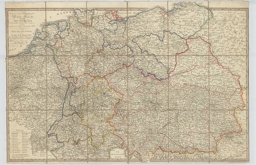
| Title | Neueste und Vollstaendigste Post Karte von ganz Deutschland. Niederlanden, Schweiz Pohlen, Ungarn und den angranzenden Theilen Frankreichs u. Italien. – Nouvelle Carte de Posta de toute l’Allemagne… |
| Main title | Közép-Európa: Németország, Hollandia, Svájc, Lengyelország, Magyarország, Franciaország, Olaszország postatérképe 1809-ben. |
222. Die Vertheilung des Grossviehs auf die Fläche in Oesterreich... [B IX c 61]
Institute and Museum of Military History •
B IX c
•
B IX Ausztria–Magyarország
•
B I–XV. Európa
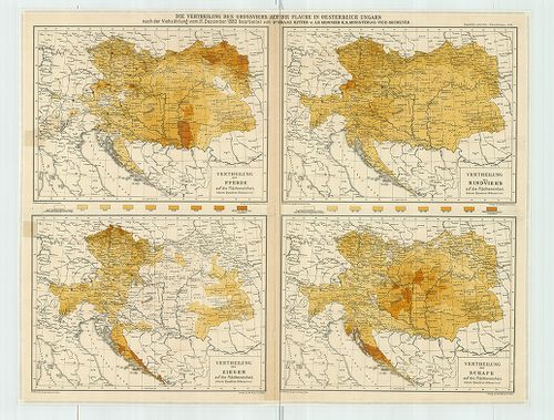
| Title | Die Vertheilung des Grossviehs auf die Fläche in Oesterreich Ungarn nach der Viehzählung vom 31. Dezember 1880. |
| Main title | 1. Vertheilung der Pferde auf die Flächeneinheit. (Az 1 km2-re eső lóállomány.) 2. Vertheilung des Rindvieh’s auf die Flächeneinheit. (Az 1 km2-re eső szarvasmarha állomány.) 3. Vertheilung der Ziegen auf die Flächeneinheit. (Az 1 km2-re eső kecske állomány.) 4. Vertheilung der Schafe auf die Flächeneinheit. (Az 1 km2-re eső birka állomány.) Mell. „Physikalisch statist Atlas v. Österreich–Ungarn. No. 23.” sz. lapja. |
| Subject | Az Oszták–Magyar Monarchia állat eloszlása km2-ként az 1880. dec. 31-i állatszámlálás alapján. |
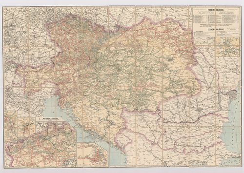
223. Carte Générale et postale du Royaume de Hongrie de la Transy... [B IX c 42/1]
Institute and Museum of Military History •
B IX c
•
B IX Ausztria–Magyarország
•
B I–XV. Európa
| Title | Carte Générale et postale du Royaume de Hongrie de la Transylvanie de la Croatie et de L’Esclavonie du Voivodat de la Serbie et du Banat du Temes du Pays des Confins Militaires et de la Bukovina. – Post und Generalcharte des Königreiches Ungarn... |
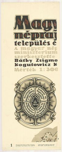
224. Magyarország néprajzi térképe település és lélekszám szerint... [B IX c 1227]
Institute and Museum of Military History •
B IX c
•
B IX Ausztria–Magyarország
•
B I–XV. Európa
| Title | Magyarország néprajzi térképe település és lélekszám szerint. – Ethnographische Karte von Ungarn. – Ethnographical Map of Hungary. – Carte Ethnographique de la Hongrie. |
| Main title | 3 mt. 1. Népsűrűség. – Density of Population. 2. Erdőségek. – Forests. 3. Magyarország közigazgatási beosztása 1910-ben. – Hungary of 1910. General Political Map. |
225. Eisenbahnkarte von Österreich–Ungarn. [B IX c 16/3]
Institute and Museum of Military History •
B IX c
•
B IX Ausztria–Magyarország
•
B I–XV. Európa
| Title | Eisenbahnkarte von Österreich–Ungarn. |
| Main title | 5 mt. 1 Nordwest Böhmen. (ÉNy-Csehország.) 2. Wiener Stadtbahn. (Bécsi városi vasút.) 3. Südliche Lokalstrecken von Wien. (Bécs helyi vasutai.) 4. Prag und Umgebung. (Prága és környéke.) 5. Budapest. |
| Subject | Az Osztrák–Magyar Monarchia vasúttérképe 1901-ben. |
226. Plan der Puchover, Vöresköuer und Vlarer zwischen Königreich... [B IX a 683/2]
Institute and Museum of Military History •
B IX a
•
B IX Ausztria–Magyarország
•
B I–XV. Európa
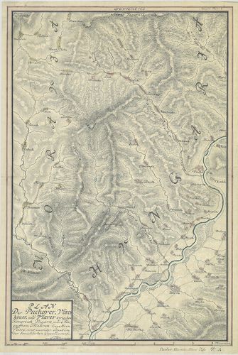
| Title | Plan der Puchover, Vöresköuer und Vlarer zwischen Königreich Ungarn und Margrafftum Mähren liegenden Pässe, samt accurater situation der benachbarten Gegeend… |
| Main title | A Magyar Királyság és a Morva Őrgrófság közötti hágók térképe. Bemutatja a Vöröskő-szoros (Puho, Puchov) térképét és Cosel várát az Odera mentén. |
227. Magyarország néprajzi térképe. – Ethnographische Karte von U... [B IX c 1084]
Institute and Museum of Military History •
B IX c
•
B IX Ausztria–Magyarország
•
B I–XV. Európa
| Title | Magyarország néprajzi térképe. – Ethnographische Karte von Ungarn. – Ethnographical Map of Hungary. – Carte Ethnographique de la Hongrie. |
| Main title | 4 mt.: 1. Népsűrűség. (Density of population. 2. Erdőségek. (Forests.) 3. Lakatlan területek. (Uninhabited Regions.) 4. Magyarország közigazgatási beosztása 1910-ben. (Hungary of 1910 General Political Map.) |
228. Carte de la Hongrie d’avant et d’aprés le Traité de Paix de ... [B XV a 171]
Institute and Museum of Military History •
B XV a
•
B XV Magyarország (1920 után)
•
B I–XV. Európa
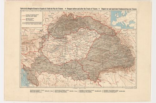
| Title | Carte de la Hongrie d’avant et d’aprés le Traité de Paix de Trianon. – Hungary before and after the treaty of Trianon. – Ungarn vor und nach dem Friedensvertrag von Trianon. |
| Main title | Mt.: [Csonka-Magyarország helyzete Európában.]Magyarország a trianoni békeszerződés előtt és után. |
229. Neue Eisenbahn-Karte von Oesterreich–Ungarn. [B IX c 12/5]
Institute and Museum of Military History •
B IX c
•
B IX Ausztria–Magyarország
•
B I–XV. Európa
| Title | Neue Eisenbahn-Karte von Oesterreich–Ungarn. |
| Main title | Mt. Nord-Böhmen. (É-Csehország.) |
| Subject | 3 térk. mell.1. Specialkarte der Umgegend von Prag. (Prága környéke.) 2. Uebersichtskarte der Eisenbahnen im östliche Europe. (K-Európa vasúttérképe.) 3. Erdkarte zur übersicht des Schnellverkehrs. (A világ gyorsforgalmi térképe.) |
230. Gränz-Carte des strittigen Antheils zwischen Pohlen u. Ungar... [B IX c 1471]
Institute and Museum of Military History •
B IX c
•
B IX Ausztria–Magyarország
•
B I–XV. Európa
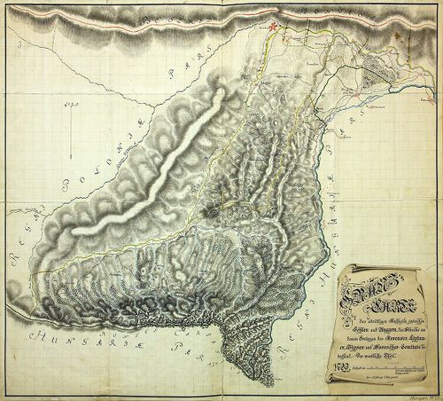
| Title | Gränz-Carte des strittigen Antheils zwischen Pohlen u. Ungarn, die Strecke an denen Gränzen des Arvenser, Liptauer, Zipser u. Saroscher-Comitats betreffend. Der westliche Theil. Levee a la hatte par l'Etat general. |
| Main title | Határtérkép Lengyelország és Magyarország között, Árva, Liptó, Szepes és Sáros megyében. |
231. Postkarte durch ganz Teutschland, Italien, Frankreich, Niede... [B IV c 63]
Institute and Museum of Military History •
B IV c
•
B IV Német birodalom
•
B I–XV. Európa
| Title | Postkarte durch ganz Teutschland, Italien, Frankreich, Niederland, Preussen, Polen und Ungarn. – Carte de Postes d’Allemagne, d’Italie, de France, des Pais Bas, de Hongrie, de la Prusse et de la ci devant Pologne. |
| Main title | Mt.: Postkurs von Florenz bis Neapol. (Postahálózat Firenzé-től Nápolyig.) |
232. Neue Verkehrskarte von Österreich–Ungarn. G. Freytag’s [B IX c 1012]
Institute and Museum of Military History •
B IX c
•
B IX Ausztria–Magyarország
•
B I–XV. Európa
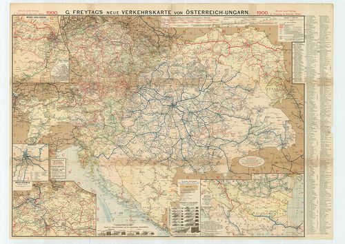
| Title | Neue Verkehrskarte von Österreich–Ungarn. G. Freytag’s |
| Main title | 5 mt. 1. Wiener Lokalverkehr. (Bécsi helyi közlekedés.) 2. Wiener Stadtbahn. (Bécsi városi vasút.) 3. Budapest. 4. Nord-Böhmen. (É-Csehország.) 5. Mittel-Europa. (Közép-Európa–Románia–Bulgária és Törökország.) |
| Subject | Ausztria–Magyarország közlekedési térképe 1900-ban. |
233. Artaria’s Eisenbahn- u. Post- Communications-Karte v. Oester... [B IX c 18/1]
Institute and Museum of Military History •
B IX c
•
B IX Ausztria–Magyarország
•
B I–XV. Európa
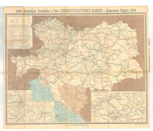
| Title | Artaria’s Eisenbahn- u. Post- Communications-Karte v. Oesterreich–Ungarn 1888. |
| Main title | 3 mt. 1. Umgebung von Wien (Bécs környéke) 2. Umgebung von Budapest. (Budapest környéke.) 3. Nördliches Böhmen und Umgebung von Prag. (É-Csehország és Praha környéke.) |
| Subject | Az Osztrák–Magyar Monarchia vasút- és postatérképe. |
234. Magyarország autótérképe. – Hungary Road Map. – Hongrie Cart... [B XV c 251]
Institute and Museum of Military History •
B XV c
•
B XV Magyarország (1920 után)
•
B I–XV. Európa
| Title | Magyarország autótérképe. – Hungary Road Map. – Hongrie Carte Routiére. – Ungarn Strassenkarte. – Vengrija Dorozsnaja Karta. |
| Main title | 15 mt.: 1. Sopron. 2. Szombathely. 3. Mosonmagyaróvár. 4. Győr. 5. Budapest. 6. Szolnok. 7. Eger. 8. Miskolc. 9. Nyíregyháza. 10. Debrecen. 11. Szeged. 12. Kecskemét. 13. Székesfehérvár. 14. Nagykanizsa. 15. Pécs. |
235. Militär Universal-Instradirungs-Karte von Österreich–Ungarn. [B IX c 88]
Institute and Museum of Military History •
B IX c
•
B IX Ausztria–Magyarország
•
B I–XV. Európa
| Title | Militär Universal-Instradirungs-Karte von Österreich–Ungarn. |
| Main title | 3 mt. 1. Nordwestliches Böhmen. (ÉNy-Csehország.) 2. Umgebung von Wien. (Bécs környéke.) 3. Umgebung von Prag. (Prága környéke.) 1 füz. 24 p. vasútállomások névjegyzéke a Monarchiában. |
| Subject | Az Osztrák–Magyar Monarchia általános vasúti katonai irányító térképe 1884-ben. |
236. Eisenbahn-Karte von Oesterreich–Ungarn. [B IX c 10/1]
Institute and Museum of Military History •
B IX c
•
B IX Ausztria–Magyarország
•
B I–XV. Európa
| Title | Eisenbahn-Karte von Oesterreich–Ungarn. |
| Main title | Eisenbahnkarte für Touristen. (Vasúttérkép a kirándulásokhoz.) 1 térk. mell. Eisenbahnkarte von Mitteleuropa. (Közép-Európa vasúttérképe.) |
| Subject | Mt. [Oroszország vasúttérképe.] Hátlapon: Eisenbahnkarte von Böhmen Mähren und Schlesien. (Csehország, Morvaország és Szilézia vasúttérképe.) A borító belső oldalán 3 mt. 1. [Bécs] 2. [Prága.] 3. [Budapest.] |
237. Bereiche der Feldtransportleitungen, der Eisenbahnlinienkomm... [B IX c 20/9]
Institute and Museum of Military History •
B IX c
•
B IX Ausztria–Magyarország
•
B I–XV. Európa
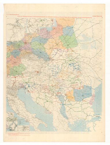
| Title | Bereiche der Feldtransportleitungen, der Eisenbahnlinienkommandos mit selbständiger Instradierung in Österreich–Ungarn und der anscliessenden deutschen Linienkommandanturen. |
| Main title | 5 mt. 1. Wien. (Bécs.) 2. Sopron. 3. Szeged. 4. Villach-Klagenfurt-Laibach (Ljubljana)-Triest (Trieste). 5. Prag. (Prága.) |
| Subject | Az Osztrák–Magyar Monarchia és a csatlakozó német vasútparancsnokságok térképe 1918-ban. |
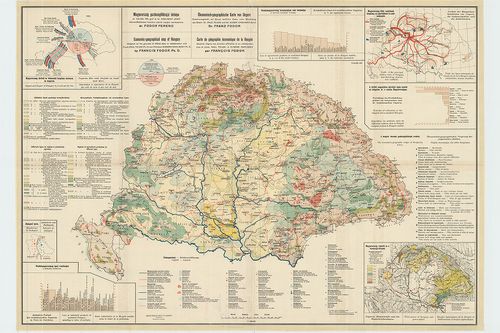
238. Magyarország gazdaságföldrajzi térképe. dr. Teleki Pál és dr... [B XV c 530]
Institute and Museum of Military History •
B XV c
•
B XV Magyarország (1920 után)
•
B I–XV. Európa
| Title | Magyarország gazdaságföldrajzi térképe. dr. Teleki Pál és dr. Cholnoky Jenő közreműködésével. Ökonomisch–geographische Karte von Ungarn. – Economic-geographical map of Hungary. – Carte de géographie économique de la Hongrie. |
| Main title | 3 mt.: 1. Magyarország főbb vasutainak forgalma, az iparvidékek és szénmedencék. 2. Magyarország vízierői és a vízenergia-telepek. 3. Budapest ipara. |
239. Magyarország gazdaságföldrajzi térképe. Dr. Teleki Pál és Dr... [B XV c 531]
Institute and Museum of Military History •
B XV c
•
B XV Magyarország (1920 után)
•
B I–XV. Európa
| Title | Magyarország gazdaságföldrajzi térképe. Dr. Teleki Pál és Dr. Cholnoky Jenő közreműködésével. Ökonomisch–geographische Karte von Ungarn. – Economic-geographical map of Hungary. – Carte de géographie économique de la Hongrie. |
| Main title | 3 mt.: 1. Magyarország főbb vasutainak forgalma az iparvidékek és szénmedencék. 2. Magyarország vízierői és a vízenergia-telepek. 3. Budapest ipara. |
240. [Carte eines Theiles von Ungarn und Siebenburgen, worauf die... [H III c 106]
Institute and Museum of Military History •
H III c (1651–1700)
•
H III Újkori háborúk (1492–1789)
•
H Háborúk
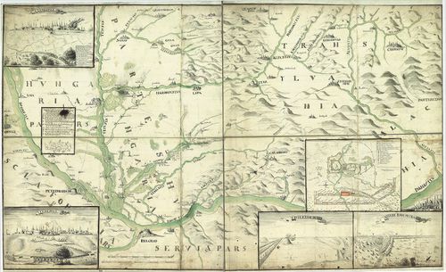
| Title | [Carte eines Theiles von Ungarn und Siebenburgen, worauf die Märsche und Campemens der kays. kgl. Armee zwischen der Theisund Maros, auch Themis und Begh Fluss angemerkt sind. |
| Main title | 2 Mt.: Temesvár látképe és alaprajza. |
| Subject | Eszék–Brassó, Kolozsvár–Belgrád közötti terület hegy- és vízrajzi térképe, hidakkal, átkelőhelyekkel. Nagyobb várak látképes ábrázolása. |