81. [Österreich–Ungarn.] Eisenbahnkarte. [B IX c 20]
Institute and Museum of Military History •
B IX c
•
B IX Ausztria–Magyarország
•
B I–XV. Európa
| Title | [Österreich–Ungarn.] Eisenbahnkarte. |
| Main title | Mt. Városokon átmenő vasutak és állomások. |
| Subject | Az Osztrák–Magyar Monarchia vasúttérképe 1900 körül. |
82. Völker- und Sprachenkarte von Österreich–Ungarn. [B IX c 125/4]
Institute and Museum of Military History •
B IX c
•
B IX Ausztria–Magyarország
•
B I–XV. Európa
| Title | Völker- und Sprachenkarte von Österreich–Ungarn. |
| Main title | A hátlapon: 5 mt.: 1. Evropy |
| Subject | 2. Rakousko-alpských zemi |
83. Ungarn und seine Nebenländer. [B IX a 509]
Institute and Museum of Military History •
B IX a
•
B IX Ausztria–Magyarország
•
B I–XV. Európa
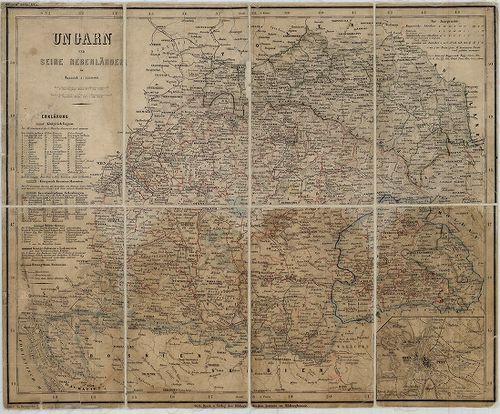
| Title | Ungarn und seine Nebenländer. |
| Main title | Mt. Ofen-Pest. (Pest-Buda várostérk.) |
| Subject | Magyarország és környékének térképe 1860 körül. |
84. Verkehrs-Karte von Oesterreich–Ungarn. Südwesten. [B IX c 292]
Institute and Museum of Military History •
B IX c
•
B IX Ausztria–Magyarország
•
B I–XV. Európa
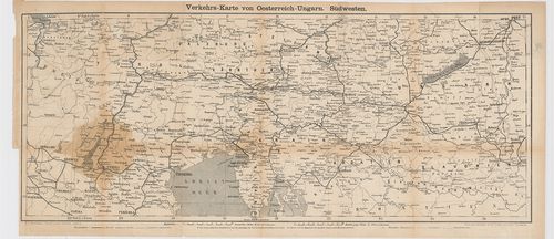
| Title | Verkehrs-Karte von Oesterreich–Ungarn. Südwesten. |
| Main title | Az Osztrák–Magyar Monarchia DNy-i részének közlekedési térképe 1871-ben. |
85. Österreich–Ungarn, Übersicht. [B IX a 1167]
Institute and Museum of Military History •
B IX a
•
B IX Ausztria–Magyarország
•
B I–XV. Európa
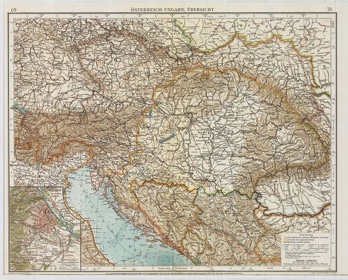
| Title | Österreich–Ungarn, Übersicht. |
| Main title | Az Osztrák–Magyar Monarchia áttekintő térképe. Az „Andrees Allgemeines Handatlas” 69–70. o. nagyítva. |
86. Das Siebenbürgische Hochland. – Europäische Wanderbilder nac... [G I h 1666]
Institute and Museum of Military History •
G I h vár alaprajzok, város és környéktérképek, utikönyvek
•
G I Európa
•
G I–V. Úti térképek
| Title | Das Siebenbürgische Hochland. – Europäische Wanderbilder nach und durch Ungarn. VIII. Bändchen. No. 175. 176. |
| Main title | Erdély vidékének útikalauza. |
87. Galizien, Nord Ungarn und ein Theil von Siebenbürgen. [B IX a 722/1]
Institute and Museum of Military History •
B IX a
•
B IX Ausztria–Magyarország
•
B I–XV. Európa
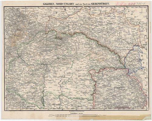
| Title | Galizien, Nord Ungarn und ein Theil von Siebenbürgen. |
| Main title | Észak-Magyarország, Galícia és Erdély egy részének térképe 1850 körül. |
88. Deutsche Kriegskarten: Galizien, Karpathen, Bukowina nebst a... [B IX c 814]
Institute and Museum of Military History •
B IX c
•
B IX Ausztria–Magyarország
•
B I–XV. Európa
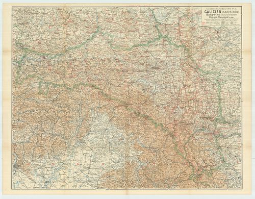
| Title | Deutsche Kriegskarten: Galizien, Karpathen, Bukowina nebst anschliessenden Ungarn, Russland usw. No. 26. |
| Main title | Galícia, Kárpát-vidék, Bukovina háborús térképe. |
89. Grundriss der Stadt und Festung Leopoldstadt in Ungarn, mit ... [G I h 394/4]
Institute and Museum of Military History •
G I h vár alaprajzok, város és környéktérképek, utikönyvek
•
G I Európa
•
G I–V. Úti térképek
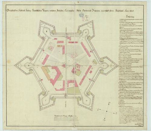
| Title | Grundriss der Stadt und Festung Leopoldstadt in Ungarn, mit ihren Gebäuden… |
| Main title | Lipótvár (Leopoldov): a vár alaprajza 1803-ban. |
90. Eigentlicher Entwurff des zwischen Ungarn und Schlesien gele... [B IX a 1131]
Institute and Museum of Military History •
B IX a
•
B IX Ausztria–Magyarország
•
B I–XV. Európa
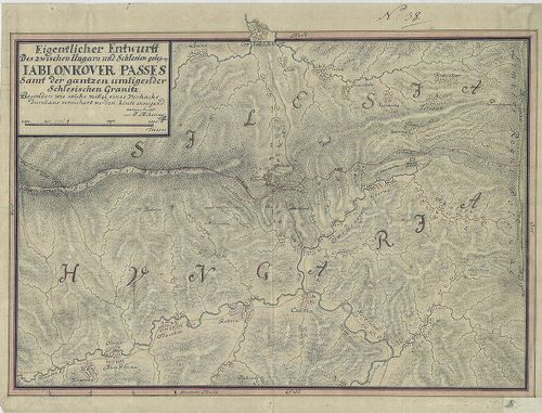
| Title | Eigentlicher Entwurff des zwischen Ungarn und Schlesien gelegene Iablonkover Passes... |
| Main title | A Jablunkai-hágó térképe a magyar-sziléziai határon. |
91. Orts und Strassen-Karte der Königreiche Ungarn, Croatien und... [B IX c 620/2]
Institute and Museum of Military History •
B IX c
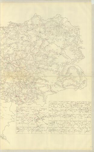
•
B IX Ausztria–Magyarország
•
B I–XV. Európa
| Title | Orts und Strassen-Karte der Königreiche Ungarn, Croatien und Slavonien des Grossfürstenthums Siebenbürgen und der k. k. Militair Graenze. |
92. Magyarország autótérképe. – Ungarn Autokarte. – Hungary Road... [B XV c 236/1]
Institute and Museum of Military History •
B XV c
•
B XV Magyarország (1920 után)
•
B I–XV. Európa
| Title | Magyarország autótérképe. – Ungarn Autokarte. – Hungary Road Map. – Hongrie Carte Routiére. – Maďarsko Automapa. – Vengrija Autokarta Ungaria Harta Automobilistică. – Madarska Autokarta. |
93. Uibersichts Karte des Kriegsschauplatzes von Ungarn und Sieb... [H IV c 29]
Institute and Museum of Military History •
H IV c (1841–1913)
•
H IV Újabbkori háborúk
•
H Háborúk
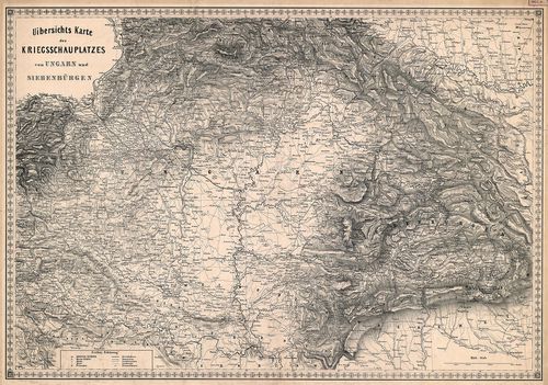
| Title | Uibersichts Karte des Kriegsschauplatzes von Ungarn und Siebebürgen. |
| Main title | Magyarország mint az 1848–1849. évi háború színtere. Települések, útvonalak. |
94. Eisenbahnkarte von Österreich–Ungarn. [B IX c 21]
Institute and Museum of Military History •
B IX c
•
B IX Ausztria–Magyarország
•
B I–XV. Európa
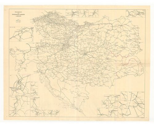
| Title | Eisenbahnkarte von Österreich–Ungarn. |
| Main title | Az Osztrák–Magyar Monarchia vasúttérképe 1914-ben, a csapatszállásoknál tekintetbe jövő menetrendek és menettartamok. |
95. A Duna folyam hossz-szelvénye Magyarországban. – Profil en l... [B IX b 139/4]
Institute and Museum of Military History •
B IX b
•
B IX Ausztria–Magyarország
•
B I–XV. Európa
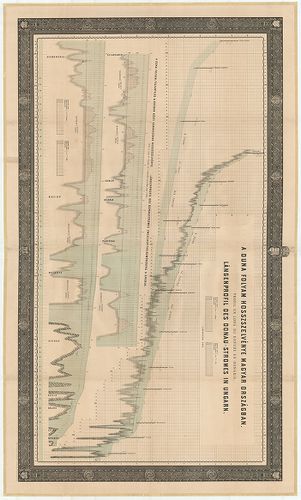
| Title | A Duna folyam hossz-szelvénye Magyarországban. – Profil en long du Danube en Hongrie. – Längenprofil der Donau in Ungarn. (Pozsonytól – Islasig) |
96. Administrativ- und General-Karte des Königreiches Ungarn. [B IX a 521/2]
Institute and Museum of Military History •
B IX a
•
B IX Ausztria–Magyarország
•
B I–XV. Európa
| Title | Administrativ- und General-Karte des Königreiches Ungarn. |
| Main title | A Magyar Királyság közigazgatási térképe 1869-ben, a II. katonai felmérés alapján. |
97. Administrativ- und General-Karte des Königreichs Ungarn. [B IX a 521/3]
Institute and Museum of Military History •
B IX a
•
B IX Ausztria–Magyarország
•
B I–XV. Európa
| Title | Administrativ- und General-Karte des Königreichs Ungarn. |
| Main title | A Magyar Királyság közigazgatási térképe 1870-ben, a II. katonai felmérés alapján. |
98. Administrativ- und General-Karte des Königreichs Ungarn. [B IX a 521/4]
Institute and Museum of Military History •
B IX a
•
B IX Ausztria–Magyarország
•
B I–XV. Európa
| Title | Administrativ- und General-Karte des Königreichs Ungarn. |
| Main title | A Magyar Királyság közigazgatási térképe 1872-ben, a II. katonai felmérés alapján. |
99. Administrativ- und General-Karte des Königreichs Ungarn. [B IX a 521/5]
Institute and Museum of Military History •
B IX a
•
B IX Ausztria–Magyarország
•
B I–XV. Európa
| Title | Administrativ- und General-Karte des Königreichs Ungarn. |
| Main title | A Magyar Királyság közigazgatási térképe 1874-ben, a II. katonai felmérés alapján. |
100. Post- und Eisenbahn-Reisekarte. Deutschland, Holland, Belgie... [B IV c 88/1]
Institute and Museum of Military History •
B IV c
•
B IV Német birodalom
•
B I–XV. Európa
| Title | Post- und Eisenbahn-Reisekarte. Deutschland, Holland, Belgien, die Schweiz, Italien bis Neapel der grösste Theil von Frankreich, Ungarn, Polen etc. |