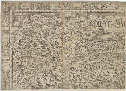
201. Carinthia Ducatus distincta in Superiorem et Inferior. Cum i... [B IX a 303]
Institute and Museum of Military History •
B IX a
•
B IX Ausztria–Magyarország
•
B I–XV. Európa
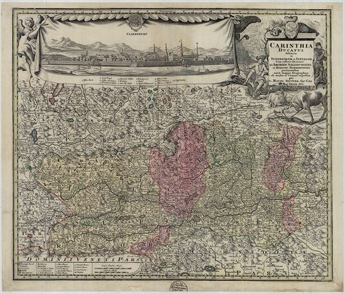
| Title | Carinthia Ducatus distincta in Superiorem et Inferior. Cum insertis Dominiis ad Archiep. Salisburgens. et Episcop. Bambergensis… |
| Main title | A Karintiai Hercegség, a Salzburgi Érsekség és a Bambergi Püspökség térképe 1730 körül. |
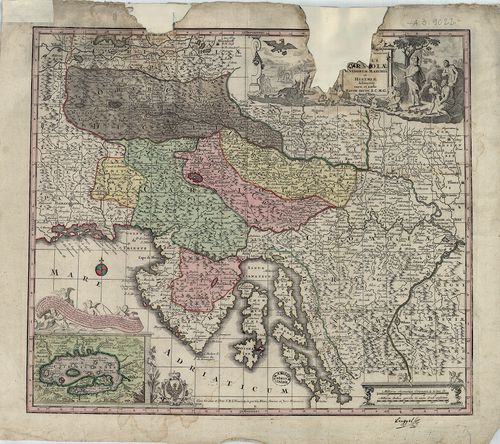
202. Carinthia Ducatus distincta in Superiorem et Inferior, cum i... [B IX a 303]
Institute and Museum of Military History •
B IX a
•
B IX Ausztria–Magyarország
•
B I–XV. Európa
| Title | Carinthia Ducatus distincta in Superiorem et Inferior, cum insertis Dominiis ad. Archiep. Salisburgens. et Episcop. Bambergensis… |
| Main title | A Karintiai Hercegség, a Salzburgi Érsekség és a Bambergi Püspökség térképe. |
203. Carte vom Kreise Klagenfurthim Herzogthume Kaernshen. [B IX a 304]
Institute and Museum of Military History •
B IX a
•
B IX Ausztria–Magyarország
•
B I–XV. Európa
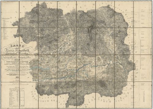
| Title | Carte vom Kreise Klagenfurthim Herzogthume Kaernshen. |
| Main title | A Klagentfurti Körzet térképe a Karintiai Hercegségben 1835-ben. |
204. Übersichtskarte von Kärnten mit den angrenzenden Ländern. [B IX a 305]
Institute and Museum of Military History •
B IX a
•
B IX Ausztria–Magyarország
•
B I–XV. Európa
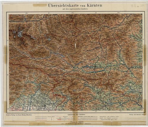
| Title | Übersichtskarte von Kärnten mit den angrenzenden Ländern. |
| Main title | Karintia áttekintő térképe 1910 körül. |
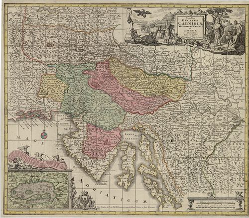
205. Exactissima Ducatus Carniolae Vindorum Marchiä et Historiae… [B IX a 307]
Institute and Museum of Military History •
B IX a
•
B IX Ausztria–Magyarország
•
B I–XV. Európa
| Title | Exactissima Ducatus Carniolae Vindorum Marchiä et Historiae… |
| Main title | Mt. Czirnitzer See. (Cerknicai tó.) |
| Subject | A Krajnai Hercegség és az Isztriai-félsziget térképe 1730. körül. |
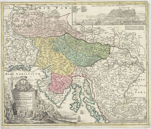
206. Exactissima Ducatus Carniolae Vindorum Marchiä et Historiae… [B IX a 308]
Institute and Museum of Military History •
B IX a
•
B IX Ausztria–Magyarország
•
B I–XV. Európa
| Title | Exactissima Ducatus Carniolae Vindorum Marchiä et Historiae… |
| Main title | Mt. Czirnitzer See. (Cerknicai-tó.) |
| Subject | A Krajnai Hercegség és az Isztriai-félsziget térképe 1760 körül. |
207. Karte vom Herzogthume Krain. [B IX a 311]
Institute and Museum of Military History •
B IX a
•
B IX Ausztria–Magyarország
•
B I–XV. Európa
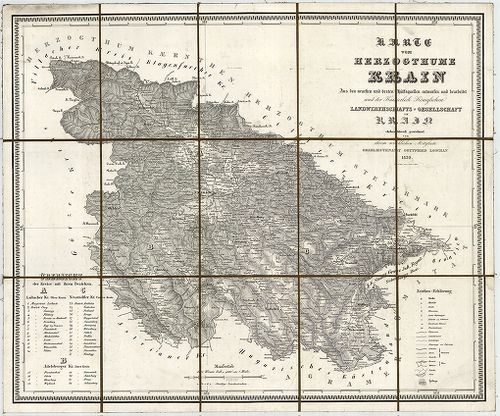
| Title | Karte vom Herzogthume Krain. |
| Main title | A Krajnai Hercegség térképe 1832-ben. |
208. Ducatus Carnioliae Tabula Chorographica, jussu sumptuque inc... [B IX a 313]
Institute and Museum of Military History •
B IX a
•
B IX Ausztria–Magyarország
•
B I–XV. Európa
| Title | Ducatus Carnioliae Tabula Chorographica, jussu sumptuque inclytorum Provinciae Statuum geometrice exhibita… |
| Main title | Mt. [Ljubljana város látképe és térk.] |
| Subject | A Krajnai Hercegség térképe 1744-ben. |
209. Tabula Ducatus Carnioliae Vindorum Marchiae et Historiae… [B IX a 314]
Institute and Museum of Military History •
B IX a
•
B IX Ausztria–Magyarország
•
B I–XV. Európa
| Title | Tabula Ducatus Carnioliae Vindorum Marchiae et Historiae… |
| Main title | 2 mt. 1. Cirkhnitzer See. (Cerknicai-tó.) 2. Laybach. (Ljubljana látképe.) |
| Subject | A Krajnai Hercegség és az Isztriai-félsziget térképe 1740 körül. |
210. Comitatus Goritia, et Gradisca, cum Limitibus Venetis et vic... [B IX a 318]
Institute and Museum of Military History •
B IX a
•
B IX Ausztria–Magyarország
•
B I–XV. Európa
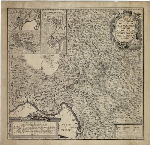
| Title | Comitatus Goritia, et Gradisca, cum Limitibus Venetis et vicinia… |
| Main title | 4 mt. 1. Trieste. 2. Gorizia. 3. Marano (Di Nogaro). 4. Gradisca városok térk. |
| Subject | Krajna: Gorozia, Gradisca és Velence környékének térképe 1756-ban. |
211. Neue topographische Carte von Istrien der Insel Cherso und V... [B IX a 325/1]
Institute and Museum of Military History •
B IX a
•
B IX Ausztria–Magyarország
•
B I–XV. Európa
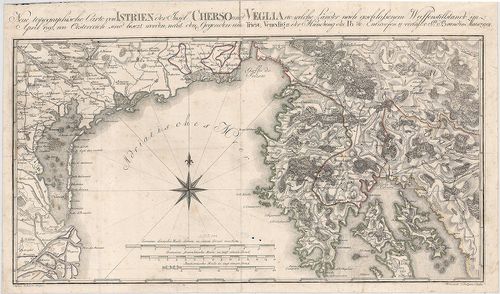
| Title | Neue topographische Carte von Istrien der Insel Cherso und Veglia etc. |
| Main title | Az Isztriai-félsziget, Cherso (Cres) és Veglia (Krk) szigetek térképe 1797-ben. |
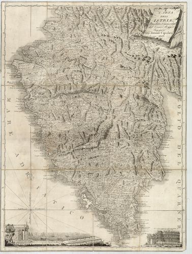
212. Nouvelle Carte de l’Istrie. [B IX a 327]
Institute and Museum of Military History •
B IX a
•
B IX Ausztria–Magyarország
•
B I–XV. Európa
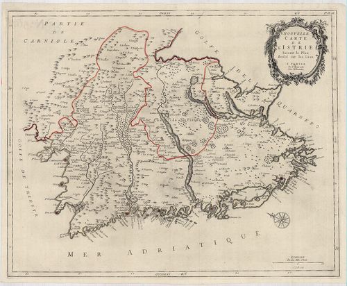
| Title | Nouvelle Carte de l’Istrie. |
| Main title | Az Isztriai-félsziget "új" térképe 1780-ban. |
213. Spezial-Karte des Lombardo – Venezianischen Königreichs. [B IX a 328]
Institute and Museum of Military History •
B IX a
•
B IX Ausztria–Magyarország
•
B I–XV. Európa
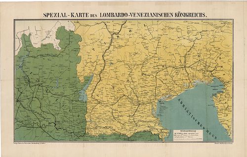
| Title | Spezial-Karte des Lombardo – Venezianischen Königreichs. |
| Main title | A Lombard-Velencei Királyság térképe 1866-ban. |
214. Carte dell Istria. [B IX a 330]
Institute and Museum of Military History •
B IX a
•
B IX Ausztria–Magyarország
•
B I–XV. Európa
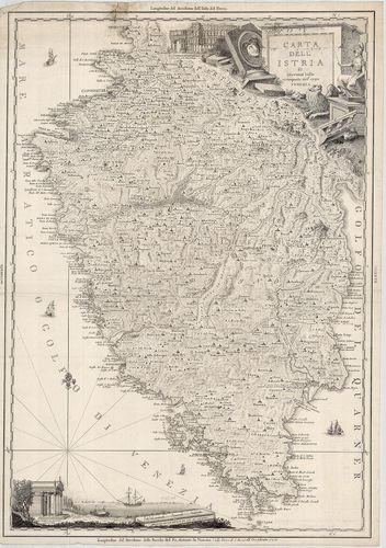
| Title | Carte dell Istria. |
| Main title | Az Isztriai-félsziget térképe 1792-ben. |
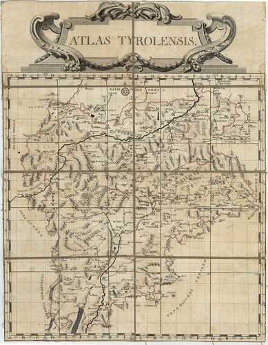
215. Tyrolis Comitatus. [B IX a 336]
Institute and Museum of Military History •
B IX a
•
B IX Ausztria–Magyarország
•
B I–XV. Európa
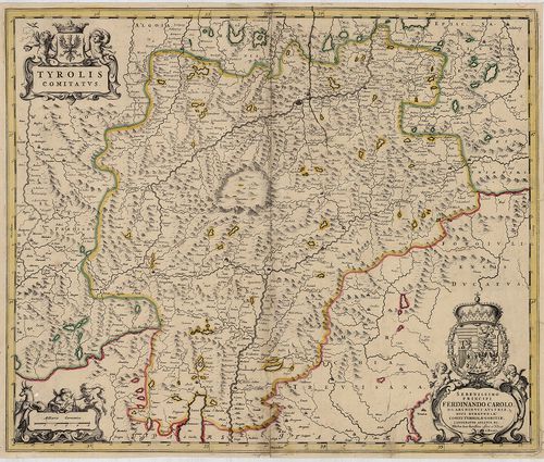
| Title | Tyrolis Comitatus. |
| Main title | A Tirol Grófság térképe a 17. században. |
216. Karte von Tirol, Steyermark und Illyrien. [B IX a 337]
Institute and Museum of Military History •
B IX a
•
B IX Ausztria–Magyarország
•
B I–XV. Európa
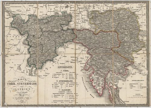
| Title | Karte von Tirol, Steyermark und Illyrien. |
| Main title | Tirol, Stájerország és Illíria térképe 1828-ban. |
217. Tyrol gegen Norden. [B IX a 338]
Institute and Museum of Military History •
B IX a
•
B IX Ausztria–Magyarország
•
B I–XV. Európa
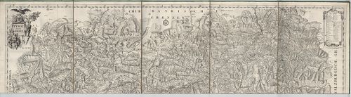
| Title | Tyrol gegen Norden. |
| Main title | Tirol É-i részének térképe a 18. században. |
218. Tyrol gegen Süden. [B IX a 339]
Institute and Museum of Military History •
B IX a
•
B IX Ausztria–Magyarország
•
B I–XV. Európa
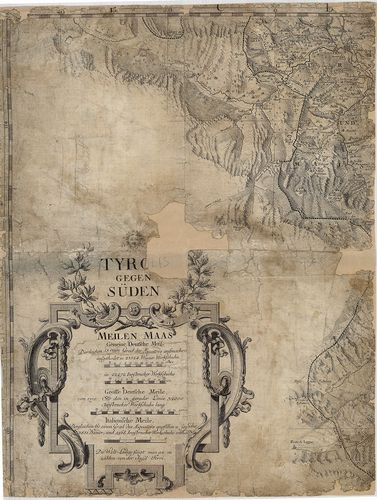
| Title | Tyrol gegen Süden. |
| Main title | Tirol D-i részének térképe a 18. században. |
219. Comitatus Principalis Tirolis in quo Episc. Tribentin et Bri... [B IX a 340]
Institute and Museum of Military History •
B IX a
•
B IX Ausztria–Magyarország
•
B I–XV. Európa
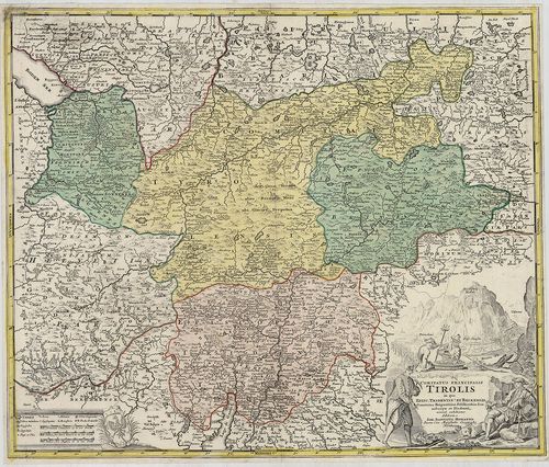
| Title | Comitatus Principalis Tirolis in quo Episc. Tribentin et Brixensis, Comitatus Brigantinus, Feldkirchiae Sonnebergae et Pludentii… |
| Main title | A Tiroli Grófság: Bregenz, Feldkircheni Grófság, Brixen, (Bressanone), Trentoi, Püspökségek térképe 1716-ban. |
220. Karte des Gefürsteten Grafschaft Tyrol. Carte der Tyrol. [B IX a 341]
Institute and Museum of Military History •
B IX a
•
B IX Ausztria–Magyarország
•
B I–XV. Európa
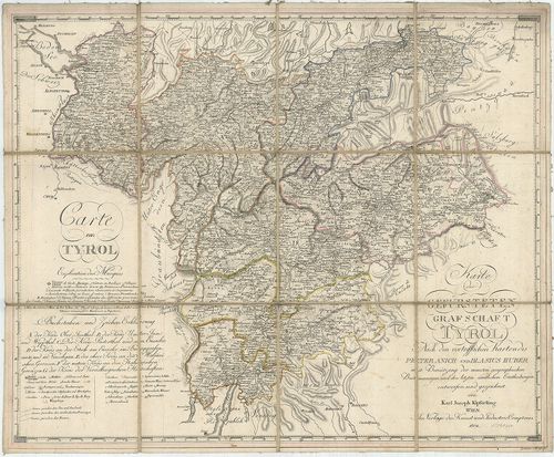
| Title | Karte des Gefürsteten Grafschaft Tyrol. Carte der Tyrol. |
| Main title | A Tiroli Grófság térképe 1804-ben. |
221. Karte der Gefürsteten Grafschaft Tyrol mit Vorarlberg. [B IX a 342]
Institute and Museum of Military History •
B IX a
•
B IX Ausztria–Magyarország
•
B I–XV. Európa
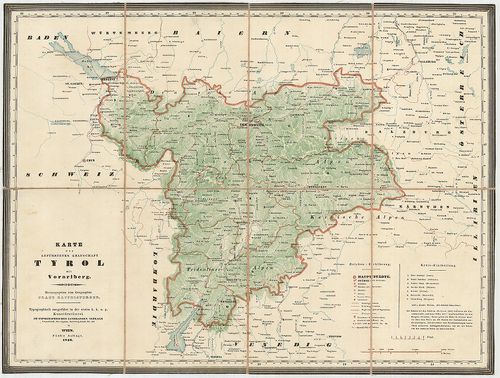
| Title | Karte der Gefürsteten Grafschaft Tyrol mit Vorarlberg. |
| Main title | A Tiroli Grófság és Vorarlberg térképe 1846-ban. |
222. Kreis, – Gerichts, – Völker, – Telegrafen. – und Post-Karte ... [B IX a 343]
Institute and Museum of Military History •
B IX a
•
B IX Ausztria–Magyarország
•
B I–XV. Európa
| Title | Kreis, – Gerichts, – Völker, – Telegrafen. – und Post-Karte der Gefürsteten Grafschaft Tyrol mit Vorarlberg. |
| Main title | A Tiroli Grófság és Vorarlberg kerületi, törvénykezési, népességi, távirda és postahálózat térképe 1850-ben. |
223. Das Kronland Tyrol und Vorarlberg … [B IX a 344]
Institute and Museum of Military History •
B IX a
•
B IX Ausztria–Magyarország
•
B I–XV. Európa
| Title | Das Kronland Tyrol und Vorarlberg … |
| Main title | A Tiroli Grófság és Vorarlberg térképe 1850-ben. |
224. Die Gefürstete Grafschaft Tirol mit Vorarlberg und das Fürst... [B IX a 344/1]
Institute and Museum of Military History •
B IX a
•
B IX Ausztria–Magyarország
•
B I–XV. Európa
| Title | Die Gefürstete Grafschaft Tirol mit Vorarlberg und das Fürstenthum Liechtenstein. |
| Main title | A Tiroli Grófság, Vorarlberg és a Liechtensteini Hercegség térképe 1864-ben. |
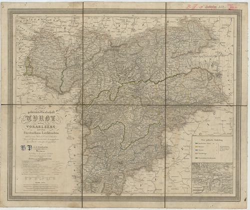
225. Handkarte der gefürsteten Grafschaft Tirol mit dem Lande Vor... [B IX a 345]
Institute and Museum of Military History •
B IX a
•
B IX Ausztria–Magyarország
•
B I–XV. Európa
| Title | Handkarte der gefürsteten Grafschaft Tirol mit dem Lande Vorarlberg. |
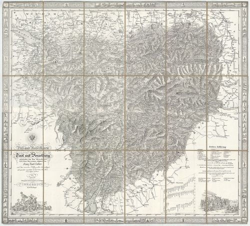
| Main title | 2 mt. 1. Bregenz und Umgebung. (Bregenz és körny.) 2. Innsbruck u. Umg. (Innsbruck és körny.) |
| Subject | A Tiroli Grófság és Vorarlberg tartomány térképe 1908-ban. |
226. Aquila Tirolensis. [B IX a 347/2]
Institute and Museum of Military History •
B IX a
•
B IX Ausztria–Magyarország
•
B I–XV. Európa
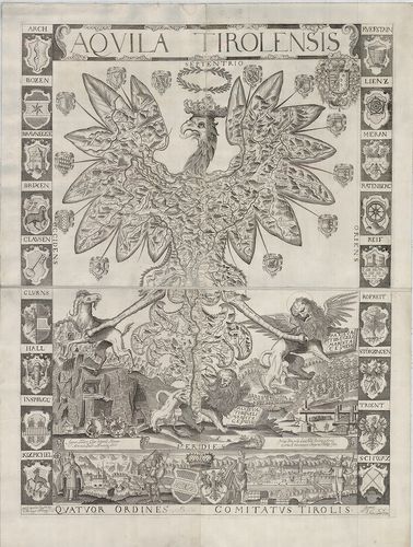
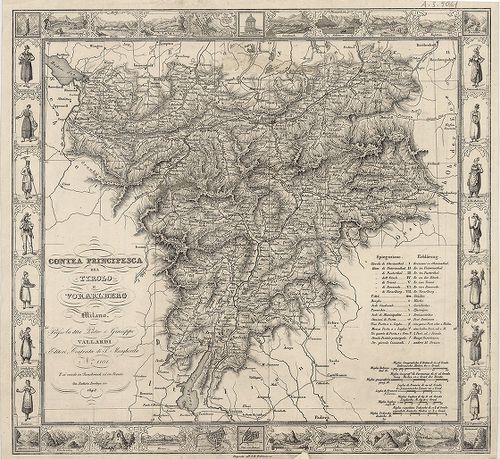
| Title | Aquila Tirolensis. |
| Main title | Tirol térképe 1620-ban. |
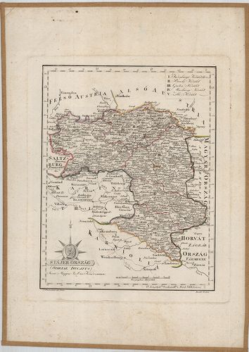
227. Stájer Ország. (Stiriae Ducatus.) [B IX a 348]
Institute and Museum of Military History •
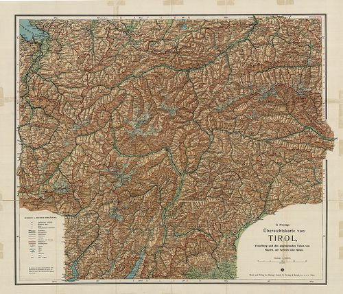
B IX a
•
B IX Ausztria–Magyarország
•
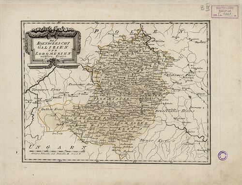
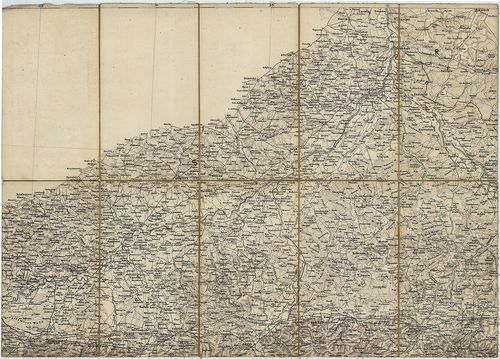
B I–XV. Európa
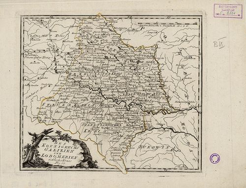
| Title | Stájer Ország. (Stiriae Ducatus.) |
| Main title | Stájerország térképe 1801-ben. |
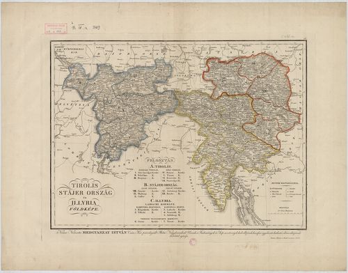
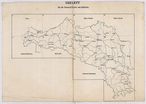
228. Tirolis, Stájer Ország és Illyria Földképe. [B IX a 349]
Institute and Museum of Military History •
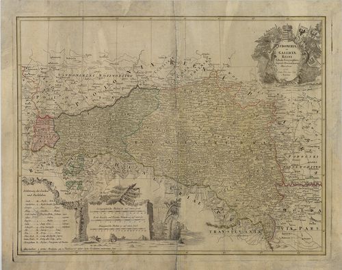
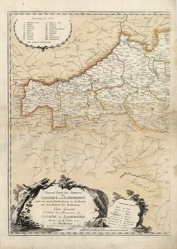
B IX a
•
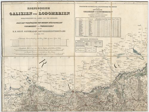
B IX Ausztria–Magyarország
•
B I–XV. Európa
| Title | Tirolis, Stájer Ország és Illyria Földképe. |
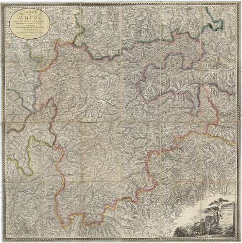
229. Carte von Tyrol nach Peter Anich und neuern Hülfsquellen ver... [B IX a 351]
Institute and Museum of Military History •
B IX a
•
B IX Ausztria–Magyarország
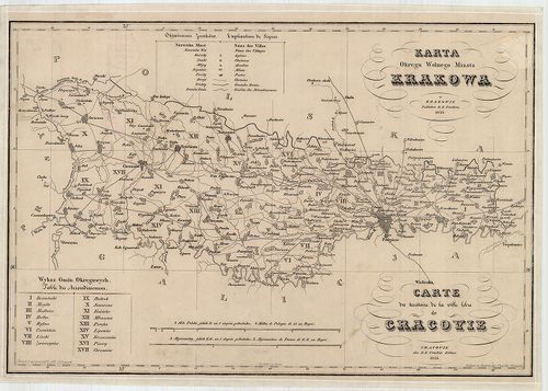
•
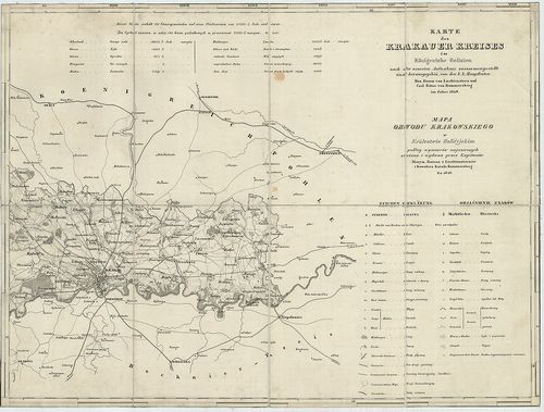
B I–XV. Európa
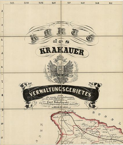
| Title | Carte von Tyrol nach Peter Anich und neuern Hülfsquellen verfast von I. E. S. |
| Main title | Tirol térképe Peter Anich térképe alapján1809-ben. |
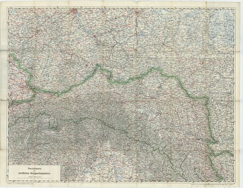
230. Die gefürstete Grafschaft Tirol nebst Vorarlberg und dem Für... [B IX a 352]
Institute and Museum of Military History •
B IX a
•
B IX Ausztria–Magyarország
•
B I–XV. Európa
| Title | Die gefürstete Grafschaft Tirol nebst Vorarlberg und dem Fürstenthum Liechtenstein… |
| Main title | Mt. Umgebungen von Innsbruck. (Innsbruck és körny.) |
| Subject | A Tiroli Grófság, Vorarlberg és a Liechtensteini Hercegség térképe 1850-ben. |
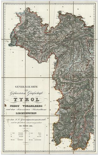
231. Generalkarte der Gefürsteten Grafschaft Tyrol nebst Vorarlbe... [B IX a 355]
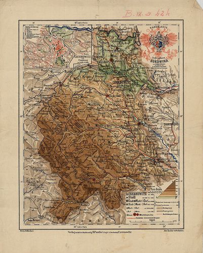
Institute and Museum of Military History •
B IX a
•
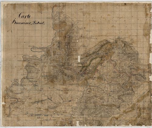
B IX Ausztria–Magyarország
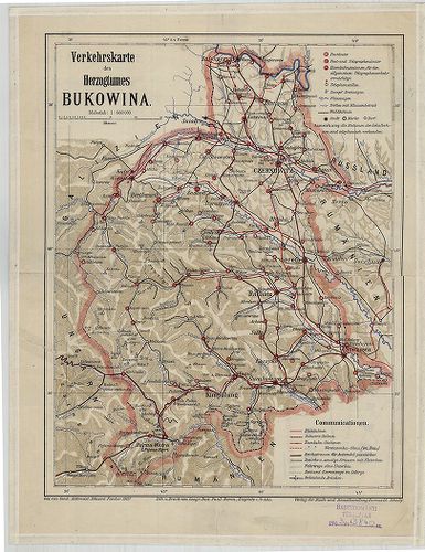
•
B I–XV. Európa
| Title | Generalkarte der Gefürsteten Grafschaft Tyrol nebst Vorarlberg und dem Souverainen Fürstenthume Liechtenstein. |
| Main title | A Tiroli Grófság, Vorarlberg és a Liechtensteini Hercegség általános térképe 1831-ben, a II. katonai felmérés alapján. |
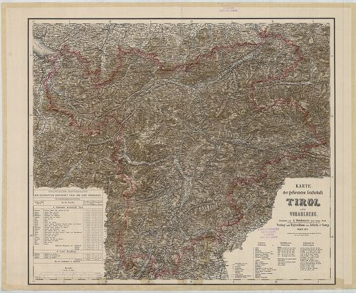
232. Karte der gefürsteten Grafschaft Tirol nebst Vorarlberg. [B IX a 356]
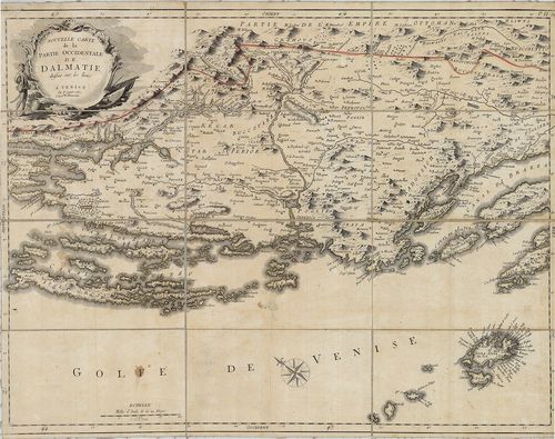
Institute and Museum of Military History •
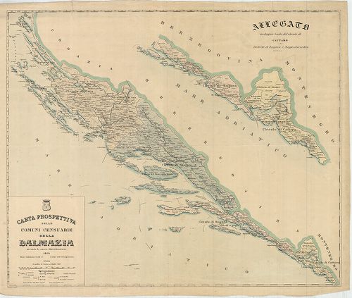
B IX a
•
B IX Ausztria–Magyarország
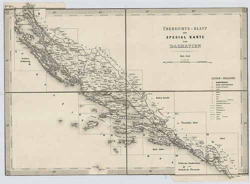
•
B I–XV. Európa
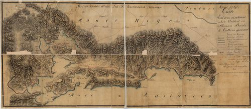
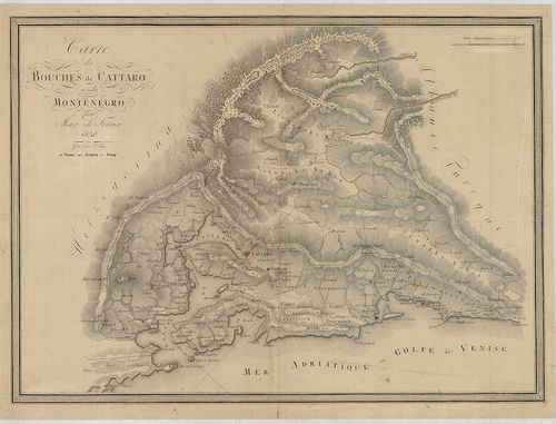
| Title | Karte der gefürsteten Grafschaft Tirol nebst Vorarlberg. |
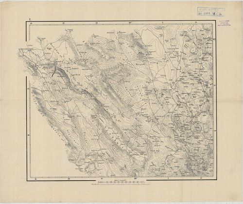
| Main title | A Tiroli Grófság és Vorarlberg térképe 1877-ben. |
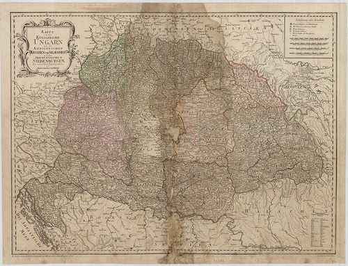
233. General Karte von Tirol und Vorarlberg. [B IX a 357]
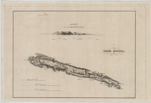
Institute and Museum of Military History •
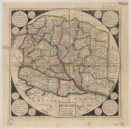
B IX a
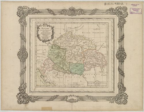
•
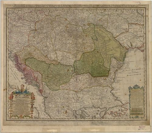
B IX Ausztria–Magyarország
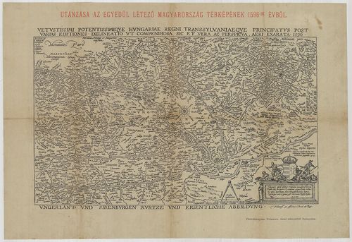
•
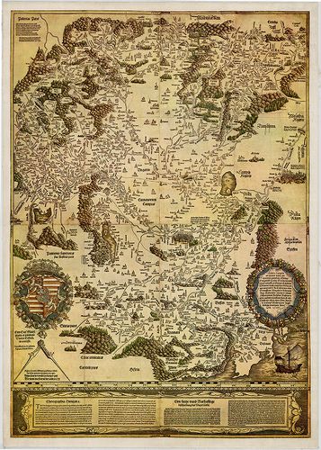
B I–XV. Európa
| Title | General Karte von Tirol und Vorarlberg. |
| Main title | Tirol és Vorarlberg általános térképe 1883-ban. |
234. Die Fr. Grafschaft Tirol. [B IX a 359]
Institute and Museum of Military History •
B IX a
•
B IX Ausztria–Magyarország
•
B I–XV. Európa
| Title | Die Fr. Grafschaft Tirol. |
| Main title | A Tiroli Grófság térképe 1629 körül. |
235. Tyrolis sub Felici Regimine Mariae Theresiae Rom. Imper. Aug... [B IX a 360/1]
Institute and Museum of Military History •
B IX a
•
B IX Ausztria–Magyarország
•
B I–XV. Európa
| Title | Tyrolis sub Felici Regimine Mariae Theresiae Rom. Imper. Aug. |
| Main title | Tirol térképe 1774-ben. |
236. Carte du Tyrol. [B IX a 361]
Institute and Museum of Military History •
B IX a
•
B IX Ausztria–Magyarország
•
B I–XV. Európa
| Title | Carte du Tyrol. |
| Main title | Tirol térképe 1801 körül. |
237. Karte der Gefürsteten Grafschaft Tyrol nebst Vorarlberg und ... [B IX a 363/1]
Institute and Museum of Military History •
B IX a
•
B IX Ausztria–Magyarország
•
B I–XV. Európa
| Title | Karte der Gefürsteten Grafschaft Tyrol nebst Vorarlberg und dem angrenzenden Souverain Fürstenthum Liechtenstein. |
| Main title | A Tiroli Grófság, Vorarlberg, és Liechtenstein részletes térképe 1823-ban, a II. katonai felmérés alapján. |
238. Contea Principesca del Tirolo e Vorarlberg. [B IX a 364]
Institute and Museum of Military History •
B IX a
•
B IX Ausztria–Magyarország
•
B I–XV. Európa
| Title | Contea Principesca del Tirolo e Vorarlberg. |
| Main title | A Tiroli Grófság és Vorarlberg térképe 1848-ban. |
239. Post- und Reise-Karte von Tirol und Vorarlberg. [B IX a 365]
Institute and Museum of Military History •
B IX a
•
B IX Ausztria–Magyarország
•
B I–XV. Európa
| Title | Post- und Reise-Karte von Tirol und Vorarlberg. |
| Main title | Tirol és Vorarlberg út- és postahálózati térképe 1831-ben. |
240. Provincia Arlbergica Sequentes Comitatus, aliosque Dominatus... [B IX a 366]
Institute and Museum of Military History •
B IX a
•
B IX Ausztria–Magyarország
•
B I–XV. Európa
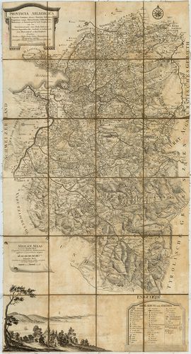
| Title | Provincia Arlbergica Sequentes Comitatus, aliosque Dominatus Austriacos, Brigantinum nempe, Hoheneckensem, Veldkirchensem, Bludentinum, et Sonnenbergensem in se Complectens… |
| Main title | Vorarlberg térképe 1783-ban. |
241. Der Nördlichste Theil Tyrols oder der Schwatzer Kreis. [B IX a 367]
Institute and Museum of Military History •
B IX a
•
B IX Ausztria–Magyarország
•
B I–XV. Európa
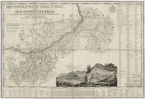
| Title | Der Nördlichste Theil Tyrols oder der Schwatzer Kreis. |
| Main title | Tirol É-i részének (Schwatzer Kreis) térképe 1790-ben. |
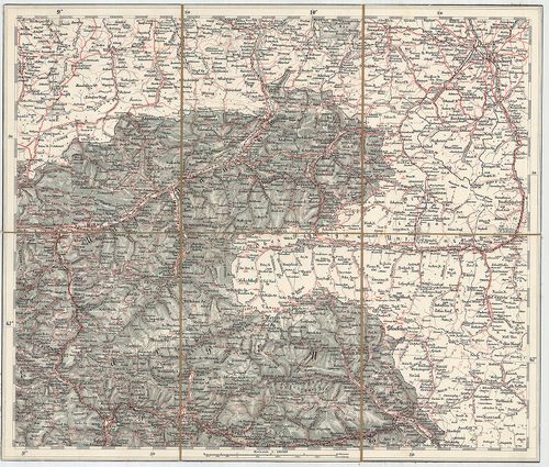
242. G. Freytags Übersichtskarte von Tirol, Vorarlberg und den an... [B IX a 367/1]
Institute and Museum of Military History •
B IX a
•
B IX Ausztria–Magyarország
•
B I–XV. Európa
| Title | G. Freytags Übersichtskarte von Tirol, Vorarlberg und den angrenzenden Teilen von Bayern der Schweiz und Italien. |
| Main title | Tirol és Vorarlberg és környékének (Bajorország, Svájc, Olaszország egy kis része) térképe 1910 körül. kerületi határokkal. |
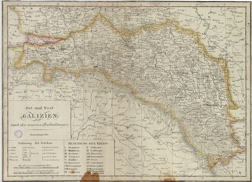
243. Ost und West Galizien. [B IX a 368]
Institute and Museum of Military History •
B IX a
•
B IX Ausztria–Magyarország
•
B I–XV. Európa
| Title | Ost und West Galizien. |
| Main title | Kelet- és Nyugat Galícia térképe a 19. század elején. |
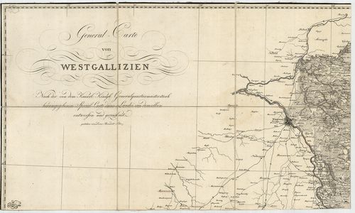
244. General Carte von Westgallizien. [B IX a 369]
Institute and Museum of Military History •
B IX a
•
B IX Ausztria–Magyarország
•
B I–XV. Európa
| Title | General Carte von Westgallizien. |
| Main title | Nyugat-Galícia általános térképe. |
245. [Dél-Tirol: Roveredo (Ol.) környéke.] [B IX a 371/1]
Institute and Museum of Military History •
B IX a
•
B IX Ausztria–Magyarország
•
B I–XV. Európa
| Title | [Dél-Tirol: Roveredo (Ol.) környéke.] |
246. Des Koenegreichs Galizien und Lodomerien mittlere Kreise. [B IX a 375]
Institute and Museum of Military History •
B IX a
•
B IX Ausztria–Magyarország
•
B I–XV. Európa
| Title | Des Koenegreichs Galizien und Lodomerien mittlere Kreise. |
| Main title | Galícia és Volhínia középső részének térképe a 19. században. |
247. Des Koenigrechs Galizien und Lodomerien östliche Kreise. [B IX a 375/1]
Institute and Museum of Military History •
B IX a
•
B IX Ausztria–Magyarország
•
B I–XV. Európa
| Title | Des Koenigrechs Galizien und Lodomerien östliche Kreise. |
| Main title | Galícia és Volhínia K-i részének térképe a 19. században. |
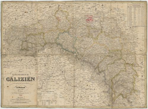
248. Das Koenigreich Galizien. [B IX a 376]
Institute and Museum of Military History •
B IX a
•
B IX Ausztria–Magyarország
•
B I–XV. Európa
| Title | Das Koenigreich Galizien. |
| Main title | A Galíciai Királyság térképe 1842-ben. |
249. Uibersichts Skelett des Königreiches Galizien und Lodomerien... [B IX a 377]
Institute and Museum of Military History •
B IX a
•
B IX Ausztria–Magyarország
•
B I–XV. Európa
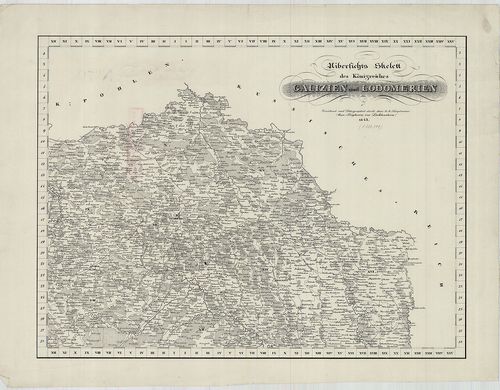
| Title | Uibersichts Skelett des Königreiches Galizien und Lodomerien. |
| Main title | Mt. Uibersicht der bestehenden Poststationen und Brief sammlungsorte. (Galícia és Volhínia áttekintő térképe a posta hivatalok, levélgyűjtőhelyek megnevezésével.) |
| Subject | Galícia és Volhínia áttekintő térképvázlata 1843-ban. Ker. jelölése. |
250. Lubomeriae et Galliciae Regni Tabula Geographica. [B IX a 378]
Institute and Museum of Military History •
B IX a
•
B IX Ausztria–Magyarország
•
B I–XV. Európa
| Title | Lubomeriae et Galliciae Regni Tabula Geographica. |
| Main title | Galícia és Volhínia térképe 1775-ben. |
251. General Charte des Atlasses von Galizien und Lodomerien nach... [B IX a 379]
Institute and Museum of Military History •
B IX a
•
B IX Ausztria–Magyarország
•
B I–XV. Európa
| Title | General Charte des Atlasses von Galizien und Lodomerien nach der neuen Eintheilung in 19. Kreise mit dem District der Buckovina. – Varte Generale de l’Atlas des Roiaumes de Galicie et Lodomerie… |
| Main title | Galícia és Volhínia általános térképe 1786-ban, a 19 ker. jelölésével. |
252. Regna Galíciae, et Lodomeriae, Iosephi II. et M. Theresiae A... [B IX a 381]
Institute and Museum of Military History •
B IX a
•
B IX Ausztria–Magyarország
•
B I–XV. Európa
| Title | Regna Galíciae, et Lodomeriae, Iosephi II. et M. Theresiae Augg. iussu methodo astronomico-trigonometrica nec non Bukovina Geometrice dimensa. |
| Main title | A Galíciai Királyság, Lodoméria (Volhínia) térképe 1800 körül, amely csillagászati-háromszögelési adatokon alapult. |
253. Koenigreich Galizien und Lodomerien herausgegeben im Jahre 1... [B IX a 382]
Institute and Museum of Military History •
B IX a
•
B IX Ausztria–Magyarország
•
B I–XV. Európa
| Title | Koenigreich Galizien und Lodomerien herausgegeben im Jahre 1790 von Liesganig. |
| Main title | Galícia és Lodoméria (Volhínia) térképe, amely Liesganig 1790-es térképének 1824-ben történő felújítása. |
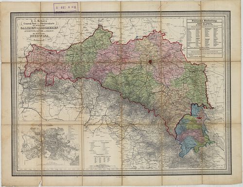
254. General-Karte des Königreiches Galizien und des Herzogthumes... [B IX a 383]
Institute and Museum of Military History •
B IX a
•
B IX Ausztria–Magyarország
•
B I–XV. Európa
| Title | General-Karte des Königreiches Galizien und des Herzogthumes Bukowina. |
| Main title | A Galíciai Királyság és a Bukovinai Hercegség általános térképe 1868-ban, a II. katonai felmérés alapján. |
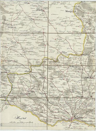
255. Administrativ-Karte von den Königreichen Galizien und Lodome... [B IX a 386]
Institute and Museum of Military History •
B IX a
•
B IX Ausztria–Magyarország
•
B I–XV. Európa
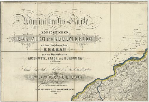
| Title | Administrativ-Karte von den Königreichen Galizien und Lodomerien mit dem Grossherzogthume Krakau und den Herzogthümern Auschwitz, Zator und Bukovina. |
| Main title | 3 mt. 1. Plan von Krakau. (Krakow várostérk.) 2. Plan von Lemberg. (Lvov várostérk.) 3. Plan von Czernowitz. (Csernovci várostérk.) |
| Subject | Galícia, Lodoméria (Volhínia), a Krakkói Nagyhercegség és a Bukovinai Hercegség topográfiai térképe 1855-ben. |
256. [Charte von Westgalizien.] [B IX a 389]
Institute and Museum of Military History •
B IX a
•
B IX Ausztria–Magyarország
•
B I–XV. Európa
| Title | [Charte von Westgalizien.] |
| Main title | Ny-Galícia (Varsó-Krakkó) közötti terület térképe a 18. század végén. |
257. General Post- und Strassenkarte des Kronlandes Galizien und ... [B IX a 390]
Institute and Museum of Military History •
B IX a
•
B IX Ausztria–Magyarország
•
B I–XV. Európa
| Title | General Post- und Strassenkarte des Kronlandes Galizien und Lodomerien Ausschwitz, (Ošviecim) Zator, und Krakau, (Kraków) so wie des Kronlandes Bukowina. |
| Main title | Mt. Plan von Lemberg. (Lvov várostérk.) |
| Subject | Galícia, Volhínia és Bukovina általános térképe 1874-ben, posta és úthálózattal. |
258. Übersichtskarte der erzherzoglichen Herrschaft Saybusch in G... [B IX a 391]
Institute and Museum of Military History •
B IX a
•
B IX Ausztria–Magyarország
•
B I–XV. Európa
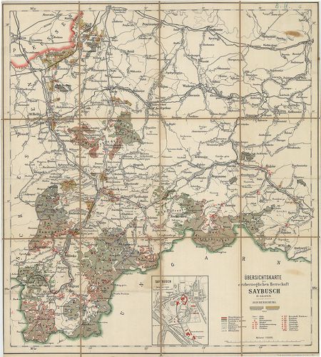
| Title | Übersichtskarte der erzherzoglichen Herrschaft Saybusch in Galizien. |
| Main title | Mt. Saybusch. (Zywiec várostérkép.) |
| Subject | Galícia: Saybusch hercegség áttekintő térképe a 19. században. |
259. Uibersichts-Karte für die Vertheidigung Tirol’s im Jahre 186... [B IX a 392]
Institute and Museum of Military History •
B IX a
•
B IX Ausztria–Magyarország
•
B I–XV. Európa
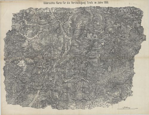
| Title | Uibersichts-Karte für die Vertheidigung Tirol’s im Jahre 1866. |
| Main title | Dél-Tirol áttekintő térképe 1866-ban. (Mühlbachtól D-re.) |
260. Mapa Komunikacyjna Galicyi i Bukowiny. [B IX a 400]
Institute and Museum of Military History •
B IX a
•
B IX Ausztria–Magyarország
•
B I–XV. Európa
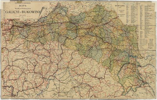
| Title | Mapa Komunikacyjna Galicyi i Bukowiny. |
| Main title | Galícia és Bukovina közlekedési térképe 1911 körül. |
261. Krakó Köz-Társaság. [B IX a 401]
Institute and Museum of Military History •
B IX a
•
B IX Ausztria–Magyarország
•
B I–XV. Európa
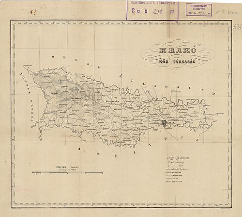
| Title | Krakó Köz-Társaság. |
262. Karte Okregu Wolnego Miasta Krakowa. – Carte du territoire d... [B IX a 402]
Institute and Museum of Military History •
B IX a
•
B IX Ausztria–Magyarország
•
B I–XV. Európa
| Title | Karte Okregu Wolnego Miasta Krakowa. – Carte du territoire de la ville libre de Cracivie. |
| Main title | Krakkó szabad terület térképe 1833-ban. |
263. Karte des Krakauer Kreisesim Königreiche Galizien. – Mapa Ob... [B IX a 403]
Institute and Museum of Military History •
B IX a
•
B IX Ausztria–Magyarország
•
B I–XV. Európa
| Title | Karte des Krakauer Kreisesim Königreiche Galizien. – Mapa Obwodu Krakowskiego w Królestwie Galicyjskim… |
| Main title | A Krakkói kerület térképe 1849-ben. |
264. Karte des Krakauer Verwaltungsgebietes. [B IX a 404]
Institute and Museum of Military History •
B IX a
•
B IX Ausztria–Magyarország
•
B I–XV. Európa
| Title | Karte des Krakauer Verwaltungsgebietes. |
| Main title | A Krakkói kerület közigazgatási térképe 1856-ban. |
265. Königreich Galicien. Kreis Przemyśl. [B IX a 405]
Institute and Museum of Military History •
B IX a
•
B IX Ausztria–Magyarország
•
B I–XV. Európa
| Title | Königreich Galicien. Kreis Przemyśl. |
| Main title | A Galíciai Királyság Przemyśli kerületének néhány szelvénye a II. katonai felmérésből: W. VI. 8., VII. 8., VIII. 7, 8. szelvények. |
266. Übersichtskarte des nördlichen Kriegsschauplatzes. [B IX a 406]
Institute and Museum of Military History •
B IX a
•
B IX Ausztria–Magyarország
•
B I–XV. Európa
| Title | Übersichtskarte des nördlichen Kriegsschauplatzes. |
| Main title | Az orosz hadszíntér áttekintő térképe 1914-ben. (Łódž, – Warscho, Varsó, Warszava – Rowno, Rovno – Schemnitz, Selmecbánya, Banska Stiavnica – Botoşani kivágat.) |
267. Karte des Wadowicer Kreises im Königreiche Galizien… – Mapa ... [B IX a 409]
Institute and Museum of Military History •
B IX a
•
B IX Ausztria–Magyarország
•
B I–XV. Európa
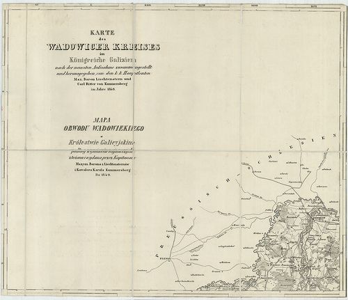
| Title | Karte des Wadowicer Kreises im Königreiche Galizien… – Mapa Obwodu Wadowiekiego w Królestwie Galicyjskim. |
| Main title | A Wadowicei kerület topográfiai térképe 1849-ben. |
268. West Galizien. I.-tes Blatt enthaltend den Krakauer, Slomnik... [B IX a 414]
Institute and Museum of Military History •
B IX a
•
B IX Ausztria–Magyarország
•
B I–XV. Európa
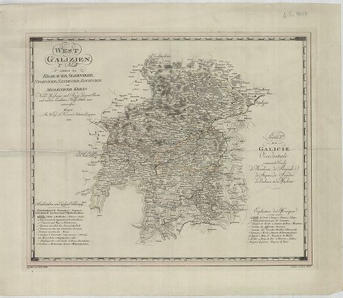
| Title | West Galizien. I.-tes Blatt enthaltend den Krakauer, Slomniker, Stopnicer, Sandecer, Bochnier und Myslenicer Kreis. – Partie I.-re de la Galicie Occidentale contenant les Cercles de Krakovie, de Slomnik de Stopnic, de Sandec, de Bochnia et de Myslenic. |
| Main title | Nyugat-Galícia térképe 1803-ban, 6 kerület megjelölésével. |
269. Ost-Galizien, Erstes Blatt enthaltend den Tarnower, Rzeszowe... [B IX a 415]
Institute and Museum of Military History •
B IX a
•
B IX Ausztria–Magyarország
•
B I–XV. Európa
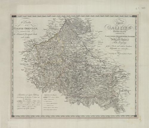
| Title | Ost-Galizien, Erstes Blatt enthaltend den Tarnower, Rzeszower, Sanoker, und Duklaer Kreis. – I. re Partie de la Galicie Orientale: Contenant les Cercles de Tarnow, de Rzeszow, de Sanok et de Dukla. |
| Main title | Kelet-Galícia térképe 1803-ban, 4 ker. megjelölésével. |
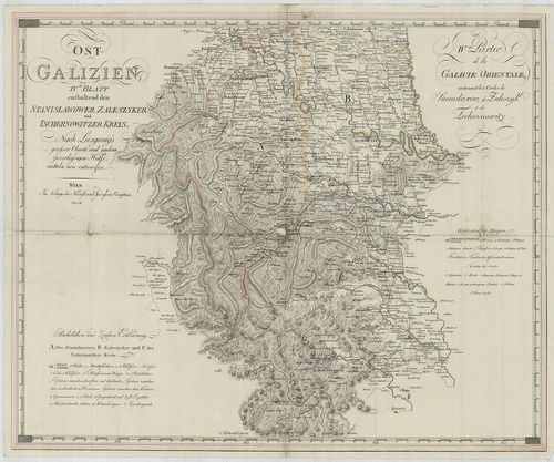
270. Ost Galizien. Zweites Blatt enthaltend den Zamoscer, Zolkiew... [B IX a 416]
Institute and Museum of Military History •
B IX a
•
B IX Ausztria–Magyarország
•
B I–XV. Európa
| Title | Ost Galizien. Zweites Blatt enthaltend den Zamoscer, Zolkiewer und Przemysler Kreis. – II. de Partie de la Galicie Orientale contenant les Cercles de Zamosc, de Zolkiev, et de Przemysl. |
| Main title | Kelet-Galícia térképe 1803-ban, 3 ker. megjelölésével. |
271. West Galizien. II-tes Blatt enthaltend den Konskier, Radomer... [B IX a 417]
Institute and Museum of Military History •
B IX a
•
B IX Ausztria–Magyarország
•
B I–XV. Európa
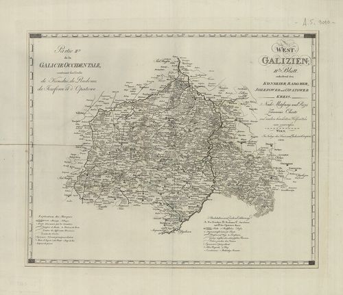
| Title | West Galizien. II-tes Blatt enthaltend den Konskier, Radomer, Jozefower und Opatower Kreis. – Partie II.-me de la Galicie Occidentale, contenant les Cercles de Konskie, de Radome, de Jozefowe et d’Opatowe. |
| Main title | Nyugat-Galícia térképe 1803-ban, 4 kerület megjelölésével. |
272. West Galizien. III.-tes Blatt enthaltend den Wiazowner, Sied... [B IX a 418]
Institute and Museum of Military History •
B IX a
•
B IX Ausztria–Magyarország
•
B I–XV. Európa
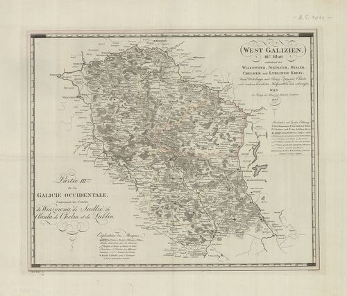
| Title | West Galizien. III.-tes Blatt enthaltend den Wiazowner, Siedlcer, Bialer, Chelmer und Lubliner Kreis. – Partie III.-me de la Galicie Occidentale, contenant les Cercles de Wiazowna, de Siedlze, de Biala, de Chelm, et de Lublin. |
| Main title | Nyugat-Galícia térképe 1803-ban, 5 kerület megjelölésével. |
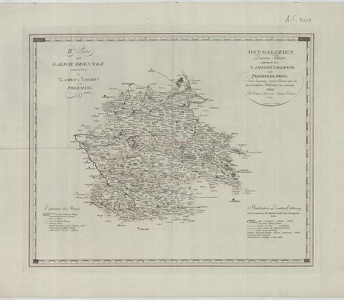
273. Ost-Galizien. IV.-es Blatt enthaltend den Sanislawoner, Zale... [B IX a 419]
Institute and Museum of Military History •
B IX a
•
B IX Ausztria–Magyarország
•
B I–XV. Európa
| Title | Ost-Galizien. IV.-es Blatt enthaltend den Sanislawoner, Zaleszyker und Tschernowitzer Kreis. – IV.-eme Partie de la Galicie Orientale, contenant les Cercles de Stanislawow, de Zaleszyk, et de Tschernowitz. |
| Main title | Kelet-Galícia térképe 1803-ban, 3 kerület megjelölésével. |
274. Galícia és Bukovina. [B IX a 420]
Institute and Museum of Military History •
B IX a
•
B IX Ausztria–Magyarország
•
B I–XV. Európa
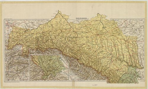
| Title | Galícia és Bukovina. |
275. Galícia és Bukovina. [B IX a 421]
Institute and Museum of Military History •
B IX a
•
B IX Ausztria–Magyarország
•
B I–XV. Európa
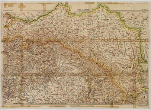
| Title | Galícia és Bukovina. |
276. Galizien und Nordost–Ungarn. [B IX a 422]
Institute and Museum of Military History •
B IX a
•
B IX Ausztria–Magyarország
•
B I–XV. Európa
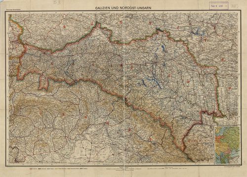
| Title | Galizien und Nordost–Ungarn. |
| Main title | Mt. Übersichtskarte von Osteuropa. (K-Európa áttekintő térk.) |
| Subject | Galícia és Magyarország ÉK-i részének térképe 1910 körül. |
277. G. Freytags Karte der Bukowina. [B IX a 423]
Institute and Museum of Military History •
B IX a
•
B IX Ausztria–Magyarország
•
B I–XV. Európa
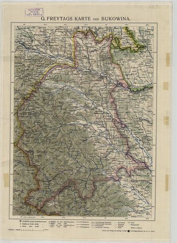
| Title | G. Freytags Karte der Bukowina. |
| Main title | Bukovina térképe 1910 körül. |
278. Handkarte des Herzogthumes Bukowina. [B IX a 424]
Institute and Museum of Military History •
B IX a
•
B IX Ausztria–Magyarország
•
B I–XV. Európa
| Title | Handkarte des Herzogthumes Bukowina. |
| Main title | Mt. Czernowitz und Umgebung. (Csernovitz, Csernovci és körny.) |
| Subject | A Bukovina Hercegség, térképe 1890 körül. |
279. [Galícia és Bukovina topográfiai térképe a 19. században.] [B IX a 425]
Institute and Museum of Military History •
B IX a
•
B IX Ausztria–Magyarország
•
B I–XV. Európa
| Title | [Galícia és Bukovina topográfiai térképe a 19. században.] |
280. Carte Bucowiner District. [B IX a 426]
Institute and Museum of Military History •
B IX a
•
B IX Ausztria–Magyarország
•
B I–XV. Európa
| Title | Carte Bucowiner District. |
| Main title | Bukovina térképe a 18. században. |
281. Verkehrskarte des Herzogtumes Bukowina. [B IX a 429]
Institute and Museum of Military History •
B IX a
•
B IX Ausztria–Magyarország
•
B I–XV. Európa
| Title | Verkehrskarte des Herzogtumes Bukowina. |
| Main title | A Bukovina Hercegség közlekedési térképe 1907-ben. |
282. Carta dell’Istria Riveduta et aumentata dol Ceasaero Reggio. [B IX a 440]
Institute and Museum of Military History •
B IX a
•
B IX Ausztria–Magyarország
•
B I–XV. Európa
| Title | Carta dell’Istria Riveduta et aumentata dol Ceasaero Reggio. |
| Main title | Az Isztriai-félsziget térképe 1803-ban. |
283. I. Charte des Nordwestlichen Theiles von Dalmatien. – Partie... [B IX a 441]
Institute and Museum of Military History •
B IX a
•
B IX Ausztria–Magyarország
•
B I–XV. Európa
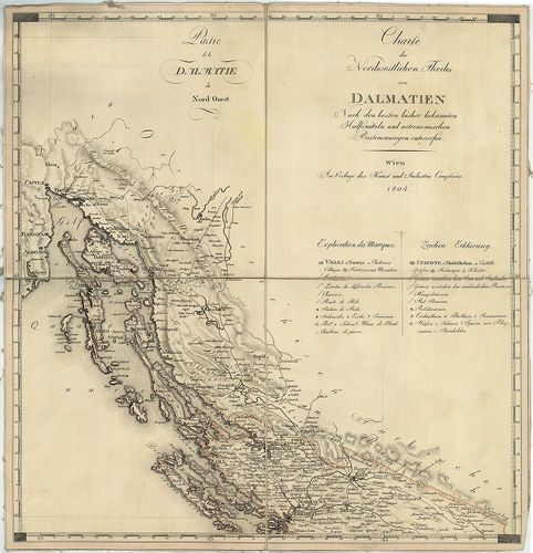
| Title | I. Charte des Nordwestlichen Theiles von Dalmatien. – Partie de la Dalmatie du Nord Quest. II. Charte des Südöstlichen Theiles von Dalmatien mit dem Oesterreichischen Antheile von Albanien. – Partie de la Dalmatie du Sud Est avec l’Albanie. |
| Main title | ÉNY- és DK-Dalmácia térképe Albánia osztrák fennhatóság alatt álló részével 1804-ben. |
284. Carta Novissima della Dalmazia, Albania, Croazia, Bosnia [B IX a 442]
Institute and Museum of Military History •
B IX a
•
B IX Ausztria–Magyarország
•
B I–XV. Európa
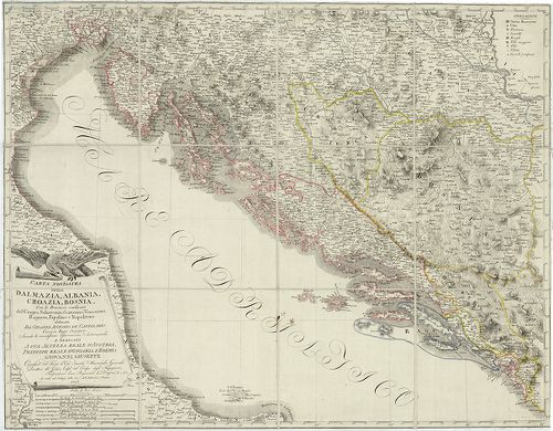
| Title | Carta Novissima della Dalmazia, Albania, Croazia, Bosnia |
| Main title | Dalmácia, Albánia, Horvátország, Bosznia "új" térképe 1806-ban, határjelöléssel. |
285. Carte des Provinces Illyriennes Comprenant La Bosnie, L’Herz... [B IX a 443]
Institute and Museum of Military History •
B IX a
•
B IX Ausztria–Magyarország
•
B I–XV. Európa
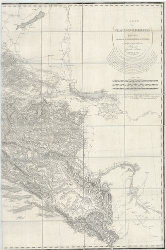
| Title | Carte des Provinces Illyriennes Comprenant La Bosnie, L’Herzegovine, Le Monténero… |
| Main title | Illiria, Bosznia–Hercegovina, Montenegro térképe 1812-ben. |
286. 1. Nouvelle Carte de la Partie Occidentale de Dalmatie. – II... [B IX a 446]
Institute and Museum of Military History •
B IX a
•
B IX Ausztria–Magyarország
•
B I–XV. Európa
| Title | 1. Nouvelle Carte de la Partie Occidentale de Dalmatie. – II. Nouvelle Carte de la Orientale de Dalmatie. |
| Main title | Mt. Baye ou Bocche di Cattaro. (Kotori-ö.) |
| Subject | Dalmácia NY-i és K-i részének "új" térképe 1780-ban. |
287. Carta prospettiva delle Comuni Censuarie della Dalmazia. [B IX a 450]
Institute and Museum of Military History •
B IX a
•
B IX Ausztria–Magyarország
•
B I–XV. Európa
| Title | Carta prospettiva delle Comuni Censuarie della Dalmazia. |
| Main title | Mt. Allegato in doppia Scala del Circolo di Cattaro e dei Distretti di Raguza e Ragusavecchia. (Kataro, Kotor, – Ragusa, Dubrovnik, – Ragusavecchia, Ragusa-Óváros, Cavtat, ker.). |
| Subject | Dalmácia közigazgatási térképe 1853-ban, kerületi beosztással. |
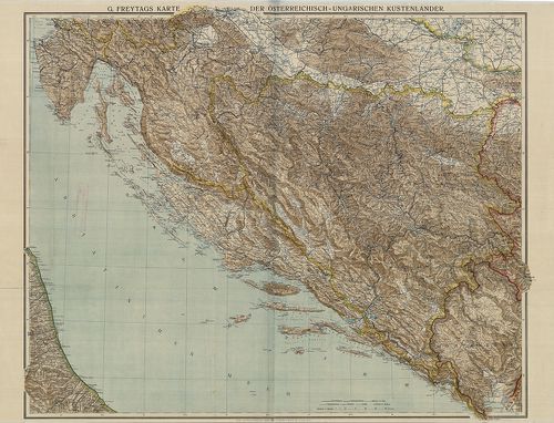
288. G. Freytags Karte der Oesterreichisch–Ungarischen Küstenländ... [B IX a 451]
Institute and Museum of Military History •
B IX a
•
B IX Ausztria–Magyarország
•
B I–XV. Európa
| Title | G. Freytags Karte der Oesterreichisch–Ungarischen Küstenländer. |
| Main title | Az Osztrák-Magyar Monarchia Tengermellék tartományának térképe 1915 körül. |
289. Carte von Dalmatien und dem Gebieth von Ragusa. [B IX a 455]
Institute and Museum of Military History •
B IX a
•
B IX Ausztria–Magyarország
•
B I–XV. Európa
| Title | Carte von Dalmatien und dem Gebieth von Ragusa. |
| Main title | Dalmácia és Raguza (Dubrovnik) térképe 1829-ben. |
290. Special-Karte des Koenigreiches Dalmatien. [B IX a 458]
Institute and Museum of Military History •
B IX a
•
B IX Ausztria–Magyarország
•
B I–XV. Európa
| Title | Special-Karte des Koenigreiches Dalmatien. |
| Main title | Dalmácia részletes térképe 1863-ban, a II. katonai felmérés alapján. |
291. Carte von dem venetianischen Antheil in Albanien Bocche die ... [B IX a 464]
Institute and Museum of Military History •
B IX a
•
B IX Ausztria–Magyarország
•
B I–XV. Európa
| Title | Carte von dem venetianischen Antheil in Albanien Bocche die Cattaro genannt. |
| Main title | A Cattaroi-öböl (Kotori-öböl) környéke 1720-ban. |
292. Carte des Bouches de Cattaro et du Montenegro. [B IX a 471]
Institute and Museum of Military History •
B IX a
•
B IX Ausztria–Magyarország
•
B I–XV. Európa
| Title | Carte des Bouches de Cattaro et du Montenegro. |
| Main title | A Cattaroi-öböl (Kotori-öböl) és Montenegró térképe 1830-ban. |
293. Süd-Dalmatien mit den angrenzenden Theilen der Herzegovina u... [B IX a 475]
Institute and Museum of Military History •
B IX a
•
B IX Ausztria–Magyarország
•
B I–XV. Európa
| Title | Süd-Dalmatien mit den angrenzenden Theilen der Herzegovina und Montenegro’s. |
| Main title | Dalmácia D-i részének és a csatlakozó hercegovinai és montenegrói területek topográfiai térképe 1870 körül, Dalmácia 1:144 000 méretarányú részletes térképének felnagyításával. |
294. Karte von dem Königreiche Ungarn mit den Königreichen Kroati... [B IX a 480]
Institute and Museum of Military History •
B IX a
•
B IX Ausztria–Magyarország
•
B I–XV. Európa
| Title | Karte von dem Königreiche Ungarn mit den Königreichen Kroatien und Sklavonien und dem Grossfürstenthum Siebenbürgen. |
| Main title | A Magyar Királyság, a Horvát-Szlavón Királyság és az Erdélyi Nagyfejedelemség térképe 1796-ban. |
295. Insel Meleda. [B IX a 481]
Institute and Museum of Military History •
B IX a
•
B IX Ausztria–Magyarország
•
B I–XV. Európa
| Title | Insel Meleda. |
| Main title | Mt. Ansicht der Insel Meleda von Nordost. (Meleda, Mljet sziget látképe ÉK-ről) |
| Subject | Meleda-sziget térképe 1825-ben. |
296. A Descript. of Hungary. [B IX a 482/1]
Institute and Museum of Military History •
B IX a
•
B IX Ausztria–Magyarország
•
B I–XV. Európa
| Title | A Descript. of Hungary. |
| Main title | Magyarország térképe 1700 körül. |
297. La Hongrie avec les Provinces adjacentes: formant tout ensem... [B IX a 482/2]
Institute and Museum of Military History •
B IX a
•
B IX Ausztria–Magyarország
•
B I–XV. Európa
| Title | La Hongrie avec les Provinces adjacentes: formant tout ensemble 2. Grandes Provinces Eclésiastiques. |
| Main title | Magyarország és a szomszédos országok térképe 1766-ban, hivatkozással az esztergomi és a kalocsai püspökségre.. |
298. Hungariae ampliori significatu et veteris vel Methodicae, co... [B IX a 482/3]
Institute and Museum of Military History •
B IX a
•
B IX Ausztria–Magyarország
•
B I–XV. Európa
| Title | Hungariae ampliori significatu et veteris vel Methodicae, complexae Regna Hungariae, Propriae, Croatiae, Dalmatiae, Bosniae, Serviae, Bulgariae, Cumaniae, Principatum Transylvaniae… |
| Main title | Magyarország (Magyar Királyság, Horvát-Szlavónia, Dalmácia, Bosznia, Szerbia, Bulgária, Erdély stb.) térképe 1744-ben. |
299. Vetustissimi Potentissimique Hungariae Regni Transsylvaniaeq... [B IX a 482/5]
Institute and Museum of Military History •
B IX a
•
B IX Ausztria–Magyarország
•
B I–XV. Európa
| Title | Vetustissimi Potentissimique Hungariae Regni Transsylvaniaeque Principatus Post Varias Editiones Denineatio ut Compendiasa sic et vera ac Perspicua, aeri exarata 1596. – Utánzása az egyedül létező Magyarország térképének 1596-ik évből. |
300. Tabula Hungarie ad quatour latera per Lazarum quondam Thomae... [B IX a 482/6]
Institute and Museum of Military History •
B IX a
•
B IX Ausztria–Magyarország
•
B I–XV. Európa
| Title | Tabula Hungarie ad quatour latera per Lazarum quondam Thomae Strigonien Cardin. Secretariu viru, exptuz congesta, á Georgio Tanstetter Collimitio reuisa auctiorqz reddita atque iamprimu á Io. Cuspiniano edita Serenissimo Hungarie et Bohemiae Regi Ferdinando principi et infanti. Hispaniarum Archiduci Austriae ec. Sacra, auspitio maiestatis suae ob reip Christiane vsum, opera Petri Apiani de Leyssnigk Mathematici Ingolstadiani inuulgata Anno Dni 1528. |
| Main title | Lázár Magyarország térképének (1528) fakszimile kiadása 1972-ben. |