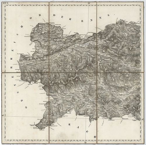
2381. Umgebungen von Steyr, Enns, und Kremsmünster. Blatt 12. [B IX a 280/6]
Institute and Museum of Military History •
B IX a
•
B IX Ausztria–Magyarország
•
B I–XV. Európa
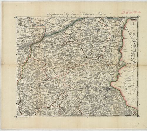
| Title | Umgebungen von Steyr, Enns, und Kremsmünster. Blatt 12. |
| Main title | Felső-Ausztria (Enns–Steyer–Kremsmünster közötti terület) topográfiai térképe. |
2382. Schulhandkarte des Herzogtums Steiermark. [B IX a 281]
Institute and Museum of Military History •
B IX a
•
B IX Ausztria–Magyarország
•
B I–XV. Európa
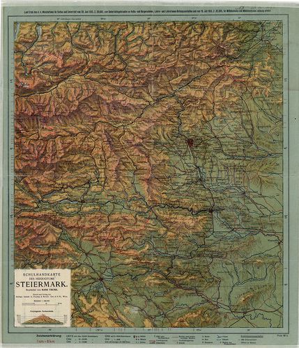
| Title | Schulhandkarte des Herzogtums Steiermark. |
| Main title | A Stájer Hercegség iskolai térképe 1913-ban. |
2383. Ducatus Stiriae Novissima Tabula ex amptiore mappa… [B IX a 282]
Institute and Museum of Military History •
B IX a
•
B IX Ausztria–Magyarország
•
B I–XV. Európa
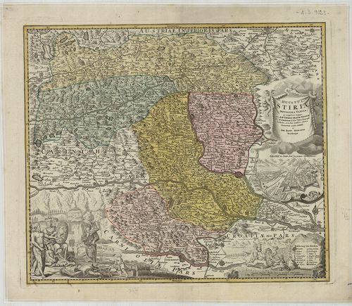
| Title | Ducatus Stiriae Novissima Tabula ex amptiore mappa… |
| Main title | Mt. Grätz die Haubt Statt des gantzen Herzogthums. (Graz főváros.) |
| Subject | A Stájer Hercegség térképe 1716-ban. |
2384. General-Karte des Herzogthums Steyermark. [B IX a 284]
Institute and Museum of Military History •
B IX a
•
B IX Ausztria–Magyarország
•
B I–XV. Európa
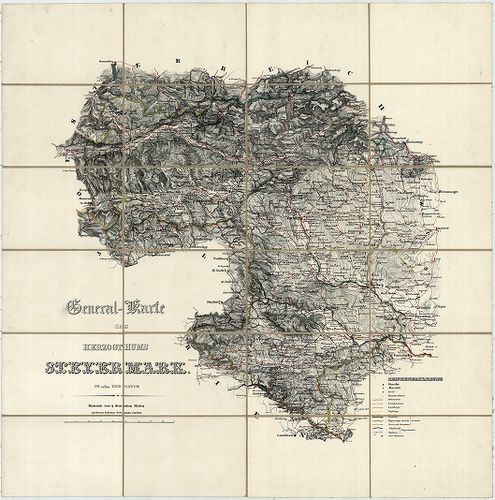
| Title | General-Karte des Herzogthums Steyermark. |
| Main title | A Stájer Hercegség általános térképe 1830 körül. |
2385. General-Karte des Herzogthums Steyermark. [B IX a 285]
Institute and Museum of Military History •
B IX a
•
B IX Ausztria–Magyarország
•
B I–XV. Európa
| Title | General-Karte des Herzogthums Steyermark. |
| Main title | A Stájer Hercegség általános térképe 1842-ben, a II. katonai felmérés alapján. |
2386. GeneralPost und Strassen Karte des Herzogthums Steiermark. [B IX a 287]
Institute and Museum of Military History •
B IX a
•
B IX Ausztria–Magyarország
•
B I–XV. Európa
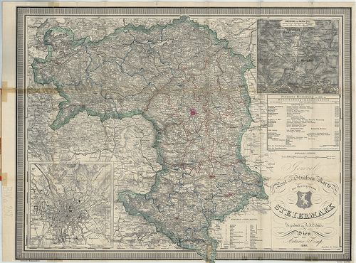
| Title | GeneralPost und Strassen Karte des Herzogthums Steiermark. |
| Main title | 2 mt. 1. Plan von Graz. (Graz várostérk.) 2. Umgebung von Maria Zell. (Máriazell és körny.) |
| Subject | A Stájer Hercegség általános, posta és úthálózati térképe 1898-ban. |
2387. Karte von Steiermark und Krain. [B IX a 289]
Institute and Museum of Military History •
B IX a
•
B IX Ausztria–Magyarország
•
B I–XV. Európa
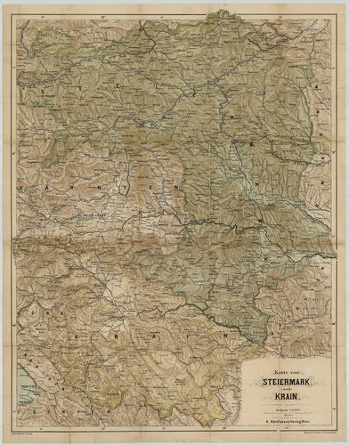
| Title | Karte von Steiermark und Krain. |
| Main title | Stájerország és Krajna térképe 1900 körül. |
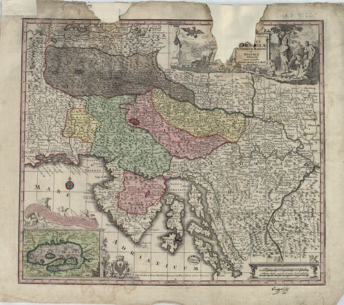
2388. Nova et accurata Carinthiae Ducatus Tabula geographica in Su... [B IX a 302]
Institute and Museum of Military History •
B IX a
•
B IX Ausztria–Magyarország
•
B I–XV. Európa
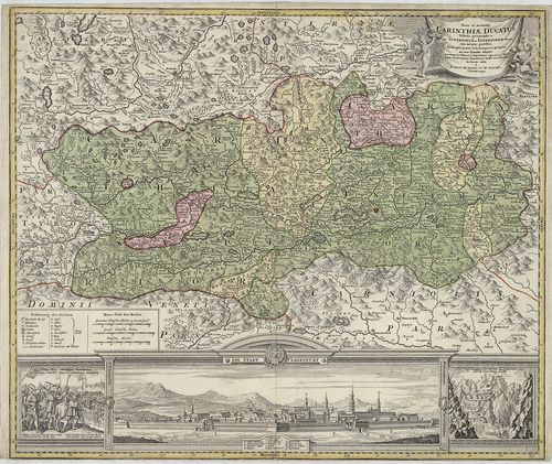
| Title | Nova et accurata Carinthiae Ducatus Tabula geographica in Superiorem et Inferiorem divisa cum infertis partibus… |
| Main title | A Stájer Hercegség térképe a 18. században. |
2389. Carinthia Ducatus distincta in Superiorem et Inferior. Cum i... [B IX a 303]
Institute and Museum of Military History •
B IX a
•
B IX Ausztria–Magyarország
•
B I–XV. Európa
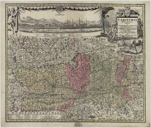
| Title | Carinthia Ducatus distincta in Superiorem et Inferior. Cum insertis Dominiis ad Archiep. Salisburgens. et Episcop. Bambergensis… |
| Main title | A Karintiai Hercegség, a Salzburgi Érsekség és a Bambergi Püspökség térképe 1730 körül. |
2390. Carinthia Ducatus distincta in Superiorem et Inferior, cum i... [B IX a 303]
Institute and Museum of Military History •
B IX a
•
B IX Ausztria–Magyarország
•
B I–XV. Európa
| Title | Carinthia Ducatus distincta in Superiorem et Inferior, cum insertis Dominiis ad. Archiep. Salisburgens. et Episcop. Bambergensis… |
| Main title | A Karintiai Hercegség, a Salzburgi Érsekség és a Bambergi Püspökség térképe. |
2391. Carte vom Kreise Klagenfurthim Herzogthume Kaernshen. [B IX a 304]
Institute and Museum of Military History •
B IX a
•
B IX Ausztria–Magyarország
•
B I–XV. Európa
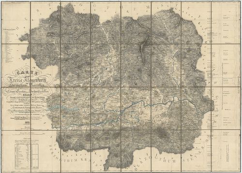
| Title | Carte vom Kreise Klagenfurthim Herzogthume Kaernshen. |
| Main title | A Klagentfurti Körzet térképe a Karintiai Hercegségben 1835-ben. |
2392. Übersichtskarte von Kärnten mit den angrenzenden Ländern. [B IX a 305]
Institute and Museum of Military History •
B IX a
•
B IX Ausztria–Magyarország
•
B I–XV. Európa
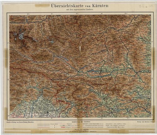
| Title | Übersichtskarte von Kärnten mit den angrenzenden Ländern. |
| Main title | Karintia áttekintő térképe 1910 körül. |
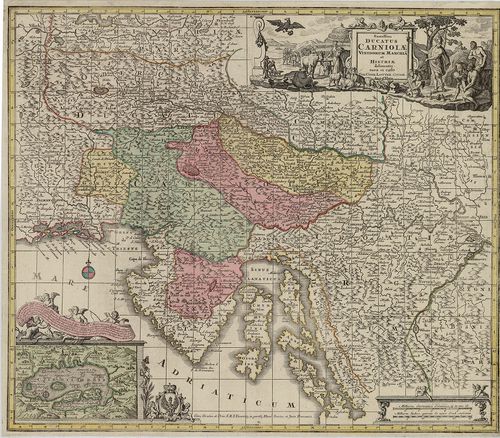
2393. Exactissima Ducatus Carniolae Vindorum Marchiä et Historiae… [B IX a 307]
Institute and Museum of Military History •
B IX a
•
B IX Ausztria–Magyarország
•
B I–XV. Európa
| Title | Exactissima Ducatus Carniolae Vindorum Marchiä et Historiae… |
| Main title | Mt. Czirnitzer See. (Cerknicai tó.) |
| Subject | A Krajnai Hercegség és az Isztriai-félsziget térképe 1730. körül. |
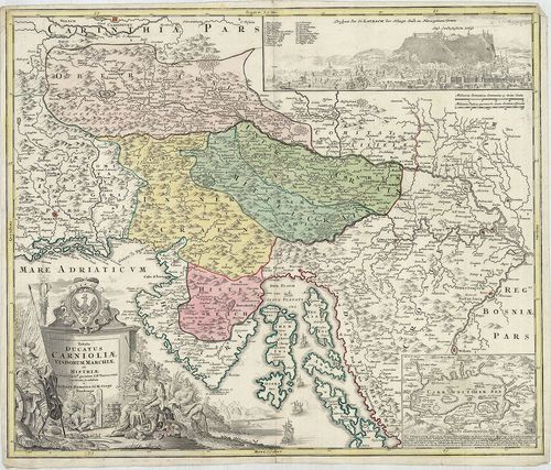
2394. Exactissima Ducatus Carniolae Vindorum Marchiä et Historiae… [B IX a 308]
Institute and Museum of Military History •
B IX a
•
B IX Ausztria–Magyarország
•
B I–XV. Európa
| Title | Exactissima Ducatus Carniolae Vindorum Marchiä et Historiae… |
| Main title | Mt. Czirnitzer See. (Cerknicai-tó.) |
| Subject | A Krajnai Hercegség és az Isztriai-félsziget térképe 1760 körül. |
2395. Karte vom Herzogthume Krain. [B IX a 311]
Institute and Museum of Military History •
B IX a
•
B IX Ausztria–Magyarország
•
B I–XV. Európa
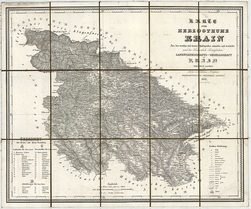
| Title | Karte vom Herzogthume Krain. |
| Main title | A Krajnai Hercegség térképe 1832-ben. |
2396. Ducatus Carnioliae Tabula Chorographica, jussu sumptuque inc... [B IX a 313]
Institute and Museum of Military History •
B IX a
•
B IX Ausztria–Magyarország
•
B I–XV. Európa
| Title | Ducatus Carnioliae Tabula Chorographica, jussu sumptuque inclytorum Provinciae Statuum geometrice exhibita… |
| Main title | Mt. [Ljubljana város látképe és térk.] |
| Subject | A Krajnai Hercegség térképe 1744-ben. |
2397. Tabula Ducatus Carnioliae Vindorum Marchiae et Historiae… [B IX a 314]
Institute and Museum of Military History •
B IX a
•
B IX Ausztria–Magyarország
•
B I–XV. Európa
| Title | Tabula Ducatus Carnioliae Vindorum Marchiae et Historiae… |
| Main title | 2 mt. 1. Cirkhnitzer See. (Cerknicai-tó.) 2. Laybach. (Ljubljana látképe.) |
| Subject | A Krajnai Hercegség és az Isztriai-félsziget térképe 1740 körül. |
2398. Comitatus Goritia, et Gradisca, cum Limitibus Venetis et vic... [B IX a 318]
Institute and Museum of Military History •
B IX a
•
B IX Ausztria–Magyarország
•
B I–XV. Európa
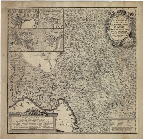
| Title | Comitatus Goritia, et Gradisca, cum Limitibus Venetis et vicinia… |
| Main title | 4 mt. 1. Trieste. 2. Gorizia. 3. Marano (Di Nogaro). 4. Gradisca városok térk. |
| Subject | Krajna: Gorozia, Gradisca és Velence környékének térképe 1756-ban. |
2399. Neue topographische Carte von Istrien der Insel Cherso und V... [B IX a 325/1]
Institute and Museum of Military History •
B IX a
•
B IX Ausztria–Magyarország
•
B I–XV. Európa
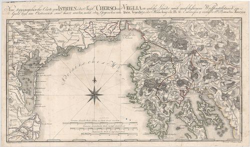
| Title | Neue topographische Carte von Istrien der Insel Cherso und Veglia etc. |
| Main title | Az Isztriai-félsziget, Cherso (Cres) és Veglia (Krk) szigetek térképe 1797-ben. |
2400. Nouvelle Carte de l’Istrie. [B IX a 327]
Institute and Museum of Military History •
B IX a
•
B IX Ausztria–Magyarország
•
B I–XV. Európa
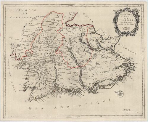
| Title | Nouvelle Carte de l’Istrie. |
| Main title | Az Isztriai-félsziget "új" térképe 1780-ban. |