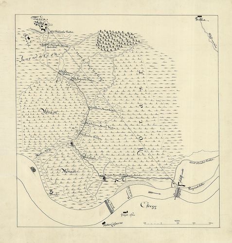
2681. Entwurff der Gegend Budinz. [B IX a 674/3]
Institute and Museum of Military History •
B IX a
•
B IX Ausztria–Magyarország
•
B I–XV. Európa
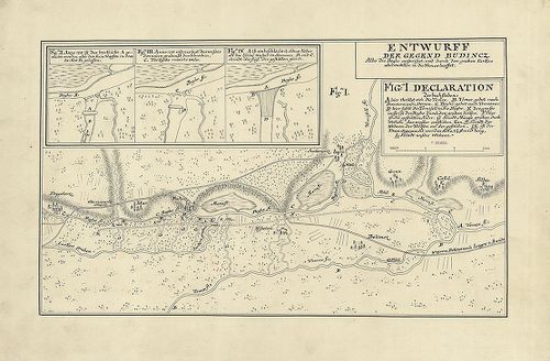
| Title | Entwurff der Gegend Budinz. |
| Main title | Budinz környékének vázlata (Temes-Béga folyó összefolyásánál). |
2682. Eigentlicher Grundtriss der Insel Schiedt in Ungern Sambt de... [B IX a 674/4]
Institute and Museum of Military History •
B IX a
•
B IX Ausztria–Magyarország
•
B I–XV. Európa
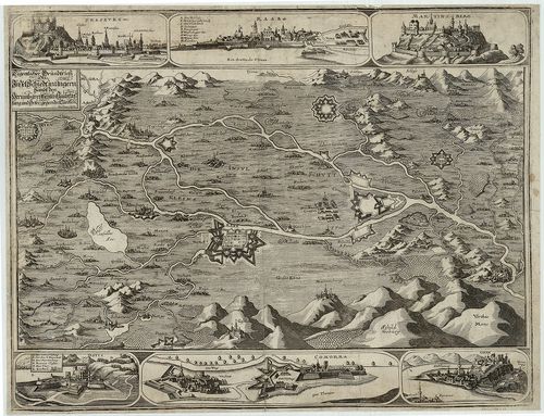
| Title | Eigentlicher Grundtriss der Insel Schiedt in Ungern Sambt den Herumbgrentzenten Haubtvestung und Orte gegenden Türken |
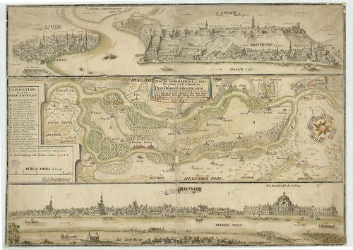
| Main title | 6 mt.: madártávl. 1. Pressburg (Pozsony–Bratislava,) 2. Raab (Győr) 3. Martinberg. (Pannonhalma) 4. Dotis (Tata) 5. Comorra (Komárom-Komarno) 6. Gran. (Esztergom) várak látképei és alaprajzai.Csallóköz és Szigetköz környéke a török hódoltság idején 1650-ben. |
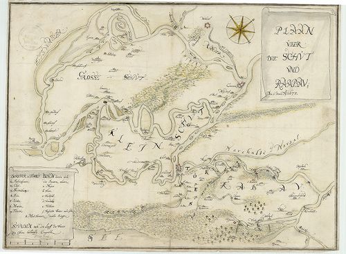
2683. [A Csallóköz és Szigetköz térképe 1664 körül.] [B IX a 674/5]
Institute and Museum of Military History •
B IX a
•
B IX Ausztria–Magyarország
•
B I–XV. Európa
| Title | [A Csallóköz és Szigetköz térképe 1664 körül.] |
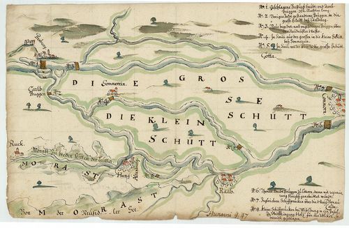
2684. Plan über die Schüt und Raaben. [B IX a 674/6]
Institute and Museum of Military History •
B IX a
•
B IX Ausztria–Magyarország
•
B I–XV. Európa
| Title | Plan über die Schüt und Raaben. |
| Main title | A Szigetköz, Csallóköz és Rábaköz térképe 1673-ban. |
2685. Mappa Geographica über die Grosse insul Csepeliense dem durc... [B IX a 674/7]
Institute and Museum of Military History •
B IX a
•
B IX Ausztria–Magyarország
•
B I–XV. Európa
| Title | Mappa Geographica über die Grosse insul Csepeliense dem durchleüchtigsten: Fürsten und herrn Eugenio Princer von Savoyen und Piemont der Rom: Kays: und Chatal: Königl: Ma˙estät, General Lieutnand zu gnädigster Observanz unwirtigst vorstehte so neyest observirt und das alte Corgirt Anno 1728 |
| Main title | 2 madártávl. mt.: 1. Buda 2. Ráczkeve. |
| Subject | A Csepel-sziget térképe 1728-ban. |
2686. Plan der Gegend zwischen Dárda und Esseg. [B IX a 674/8]
Institute and Museum of Military History •
B IX a
•
B IX Ausztria–Magyarország
•
B I–XV. Európa
| Title | Plan der Gegend zwischen Dárda und Esseg. |
| Main title | Dárda (Darda) és Eszék (Osijek) közötti terület térképe 1738 körül. |
2687. Nógrád vármegye. Törvényhatósági közutainak forgalmi térkép... [B IX a 679]
Institute and Museum of Military History •
B IX a
•
B IX Ausztria–Magyarország
•
B I–XV. Európa
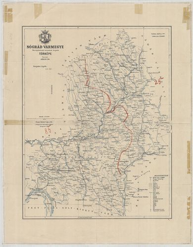
| Title | Nógrád vármegye. Törvényhatósági közutainak forgalmi térképe. |
2688. Szerém megye térképe. [B IX a 680]
Institute and Museum of Military History •
B IX a
•
B IX Ausztria–Magyarország
•
B I–XV. Európa
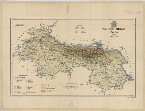
| Title | Szerém megye térképe. |
2689. Plan der Puchover, Vöresköuer und Vlarer zwischen Königreich... [B IX a 683/2]
Institute and Museum of Military History •
B IX a
•
B IX Ausztria–Magyarország
•
B I–XV. Európa
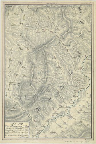
| Title | Plan der Puchover, Vöresköuer und Vlarer zwischen Königreich Ungarn und Margrafftum Mähren liegenden Pässe, samt accurater situation der benachbarten Gegeend… |
| Main title | A Magyar Királyság és a Morva Őrgrófság közötti hágók térképe. Bemutatja a Vöröskő-szoros (Puho, Puchov) térképét és Cosel várát az Odera mentén. |
2690. Plan der Gegend um Oedenburg bis an die Oesterreichische Gra... [B IX a 684/2]
Institute and Museum of Military History •
B IX a
•
B IX Ausztria–Magyarország
•
B I–XV. Európa
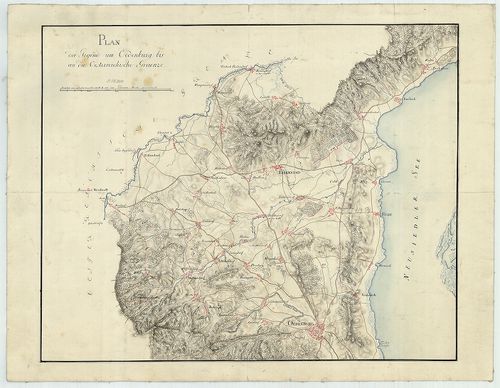
| Title | Plan der Gegend um Oedenburg bis an die Oesterreichische Graenze. |
| Main title | Sopron környékének térképe 1809 körül. |
2691. A la vue Aufnahme der Gegend von Sümegh. [B IX a 684/4]
Institute and Museum of Military History •
B IX a
•
B IX Ausztria–Magyarország
•
B I–XV. Európa
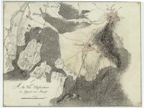
| Title | A la vue Aufnahme der Gegend von Sümegh. |
| Main title | Sümeg környékének szemmértékkel felmért topográfiai térképe 1809 körül. |
2692. Das Aufgenohmen Plans von Tappe ober Szegedin bis zur Donau ... [B IX a 685]
Institute and Museum of Military History •
B IX a
•
B IX Ausztria–Magyarország
•
B I–XV. Európa
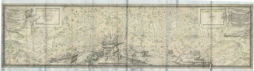
| Title | Das Aufgenohmen Plans von Tappe ober Szegedin bis zur Donau bey Salankement… |
| Main title | A Tisza vidékének topográfiai térképe 1739-ben. (Szegedtől–Ózalánkeménig, Slankamen.) |
2693. Plan der Gegend um Toka˙. [B IX a 687/1]
Institute and Museum of Military History •
B IX a
•
B IX Ausztria–Magyarország
•
B I–XV. Európa
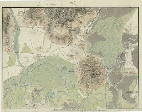
| Title | Plan der Gegend um Toka˙. |
| Main title | Tokaj és környékének topográfiai térképe 1809 körül. |
2694. Montium vitiferorum utpote Tokaiensis Tarczal Tallya mad… [B IX a 688]
Institute and Museum of Military History •
B IX a
•
B IX Ausztria–Magyarország
•
B I–XV. Európa
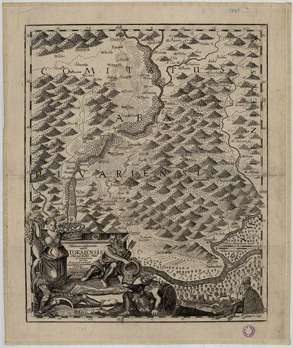
| Title | Montium vitiferorum utpote Tokaiensis Tarczal Tallya mad… |
| Main title | Tokaj, Tarcal, Tállya és Mád (Zemplén vármegye) térképe 1749-ben. |
2695. Mappa della Transilvaniae che dimastre il suo stato e passi ... [B IX a 691]
Institute and Museum of Military History •
B IX a
•
B IX Ausztria–Magyarország
•
B I–XV. Európa
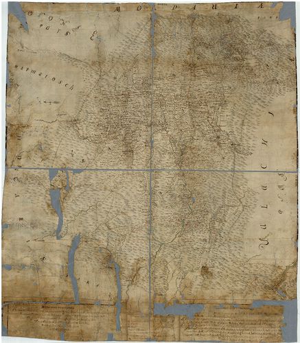
| Title | Mappa della Transilvaniae che dimastre il suo stato e passi ove puo entrare l’inimico dalla parte di Moldavia, Valachia, é Temesvarer Frontiere á queste Provincia. Marca in altre l’ingressi dalia partre dell’Ongaria communicationi dun luogho all’altro… |
| Main title | Erdély térképe a 18. században. |
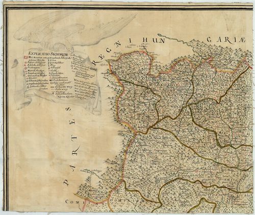
2696. Siebenbürgen II.-tes Blatt enthaltend die Südlichen Gespanns... [B IX a 692]
Institute and Museum of Military History •
B IX a
•
B IX Ausztria–Magyarország
•
B I–XV. Európa
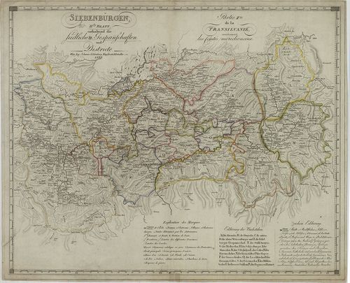
| Title | Siebenbürgen II.-tes Blatt enthaltend die Südlichen Gespannschaften und Districte. – Partie II.-me de la Transylvanie contenant les Comtes meridionaux. |
| Main title | Erdély D-i részének térképe 1826-ban. |
2697. Nova et Accurata Geographica Mappa Daciae Mediterraneae seu ... [B IX a 700]
Institute and Museum of Military History •
B IX a
•
B IX Ausztria–Magyarország
•
B I–XV. Európa
| Title | Nova et Accurata Geographica Mappa Daciae Mediterraneae seu Moderni Principatus Transylvaniae. |
| Main title | Erdély térképe 1735-ben. |
2698. Nova et accurata Geometrica Mappa Daciae Mediterraneae seu M... [B IX a 701]
Institute and Museum of Military History •
B IX a
•
B IX Ausztria–Magyarország
•
B I–XV. Európa
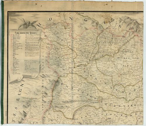
| Title | Nova et accurata Geometrica Mappa Daciae Mediterraneae seu Moderni Principatus Transylvaniae. |
| Main title | Erdély térképe 1745-ben. |
2699. Transylvania, Siebenburgen. [B IX a 702]
Institute and Museum of Military History •
B IX a
•
B IX Ausztria–Magyarország
•
B I–XV. Európa
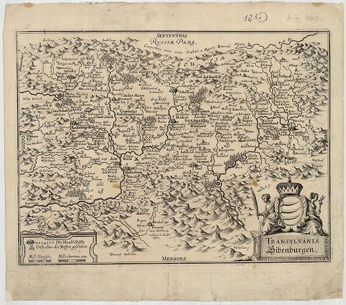
| Title | Transylvania, Siebenburgen. |
| Main title | Erdély térképe a 17. század végén. |
2700. Principauté de Transilvanie Divisée en Cinq Nations Subdivis... [B IX a 703]
Institute and Museum of Military History •
B IX a
•
B IX Ausztria–Magyarország
•
B I–XV. Európa
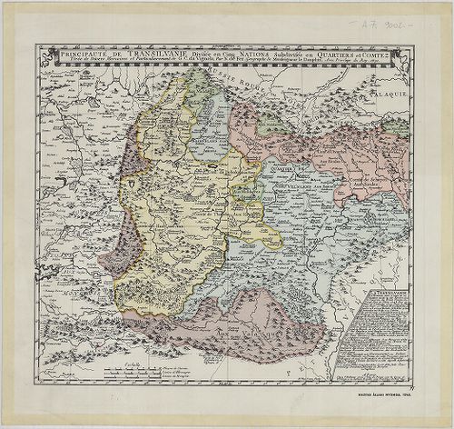
| Title | Principauté de Transilvanie Divisée en Cinq Nations Subdivisée en Qartiers et Comtez. |
| Main title | Erdély térképe 1691-ben, faximile kiadás. |