361. Military maps illustrating the Operations of the armies of t... [H IV c 125]
Institute and Museum of Military History •
H IV c (1841–1913)
•
H IV Újabbkori háborúk
•
H Háborúk
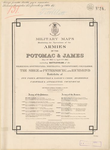
| Title | Military maps illustrating the Operations of the armies of the Potomac and James May 4th 1864 to April 9th 1865 including battlefields. |
362. Central Virginia showing lieut. Genl U. S. Grants campaing… ... [H IV c 127]
Institute and Museum of Military History •
H IV c (1841–1913)
•
H IV Újabbkori háborúk
•
H Háborúk
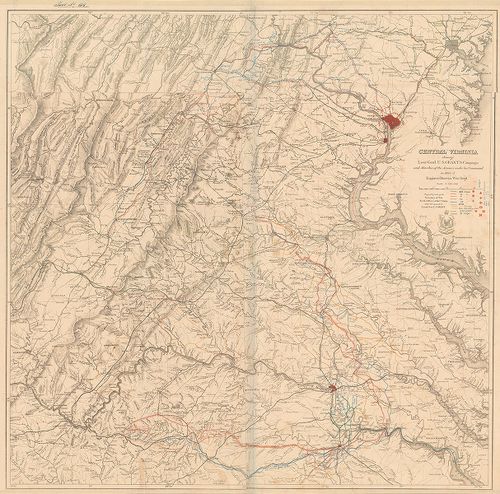
| Title | Central Virginia showing lieut. Genl U. S. Grants campaing… in 1864–65. |
| Main title | Közép-Virginia (USA): Grant tábornok hadműveleteinek színtere az észak-amerikai polgárháborúban 1864–65. A hadtestek felvonulási útjai. |
363. Map of the Battlefield of Chattanooga… 1864. [H IV c 134]
Institute and Museum of Military History •
H IV c (1841–1913)
•
H IV Újabbkori háborúk
•
H Háborúk
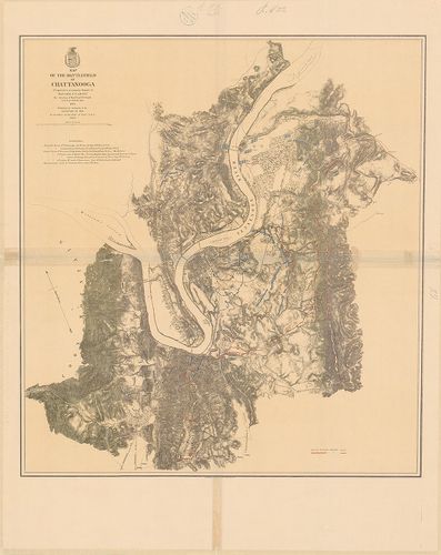
| Title | Map of the Battlefield of Chattanooga… 1864. |
| Main title | A chattanoogai (USA) ütközet helyszíne 1864. (Észak-amerikai polgárháború.) Az északiak és a déliek hadállásai, sáncai. A város alaprajzban. Útvonalak, átkelőhelyek a Tennessee-folyón. |
364. Battlefield in front of Franklin, Tenn… November 30th 1864. [H IV c 136]
Institute and Museum of Military History •
H IV c (1841–1913)
•
H IV Újabbkori háborúk
•
H Háborúk
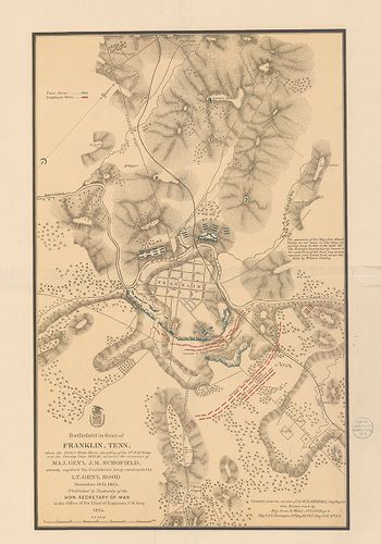
| Title | Battlefield in front of Franklin, Tenn… November 30th 1864. |
| Main title | A Franklin (USA, Tennesy) város melletti csata helyszíne 1864. (Észak-Amerikai polgárháború.) Az északiak és déliek hadállásai, sáncai. A város alaprajzban. Útvonalak. |
365. Map of the Battle Field of Gettysburg july 1st. 2nd. 3rd. 18... [H IV c 137]
Institute and Museum of Military History •
H IV c (1841–1913)
•
H IV Újabbkori háborúk
•
H Háborúk
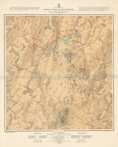
| Title | Map of the Battle Field of Gettysburg july 1st. 2nd. 3rd. 1863. |
| Main title | A gettysburgi (USA) csata (Pennsylvania) helyszínrajza. 1863. Az északi és déli haderők állásának három szakasza az észak-amerikai háborúban. Parancsnokok nevei. |
366. Battlefields in front of Nashville… December 15th and 16th 1... [H IV c 138]
Institute and Museum of Military History •
H IV c (1841–1913)
•
H IV Újabbkori háborúk
•
H Háborúk
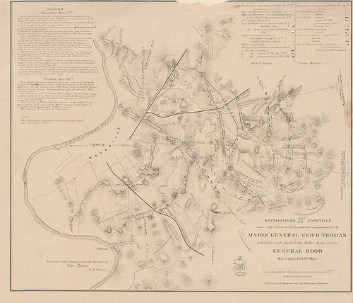
| Title | Battlefields in front of Nashville… December 15th and 16th 1864. |
| Main title | A Nashville (USA) melletti csata helyszíne 1864. (Észak-amerikai polgárháború.) Az északiak és déliek hadállásai. Útvonalak. Ismertetés. |
367. Topographical map of the approaches and defendes of Knoxvill... [H IV c 144]
Institute and Museum of Military History •
H IV c (1841–1913)
•
H IV Újabbkori háborúk
•
H Háborúk
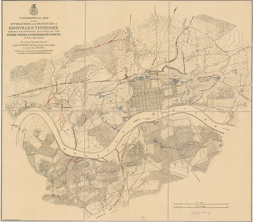
| Title | Topographical map of the approaches and defendes of Knoxville E. Tennessee Shewing the positions occupied by the United States and Confederate Forces. During the Siege. |
| Main title | Knoxville (USA, Tenn.) ostromának helyszínrajza 1863–64. (Észak-amerikai polgárháború.) Az északiak és déliek hadállásai, kiserődei. A város alaprajzban. Útvonalak. |
368. Map of the siege of Vicksburg, Missby the U. S. forces… [H IV c 146]
Institute and Museum of Military History •
H IV c (1841–1913)
•
H IV Újabbkori háborúk
•
H Háborúk
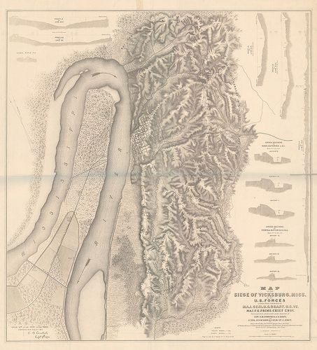
| Title | Map of the siege of Vicksburg, Missby the U. S. forces… |
| Main title | Mt.: metszetek. |
| Subject | Vicksburg (USA, Miss.) ostromának helyszínrajza 1863. (Észak-amerikai polgárháború.) Az északiak és déliek hadállásai. A város alaprajzban. Útvonalak. |
369. A., Sketch of Vicinity of Fort Fisher, 1865. (Fort Fisher (U... [H IV c 154]
Institute and Museum of Military History •
H IV c (1841–1913)
•
H IV Újabbkori háborúk
•
H Háborúk
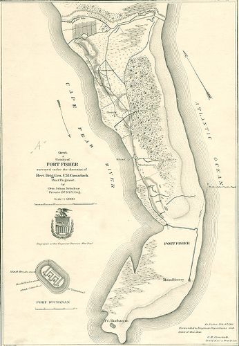
| Title | A., Sketch of Vicinity of Fort Fisher, 1865. (Fort Fisher (USA) környékének vázlatos helyszínrajza 1865.) Sáncok, utak, hadállások. |
| Main title | Mt.: a Fort Buchanan alaprajzban. |
| Subject | B., Plan and sections of Fort Fisker 1865. (Fort Fisher védőművei alaprajzban.) |
370. Military map… Harper’s Ferry Va… 1863. [H IV c 155]
Institute and Museum of Military History •
H IV c (1841–1913)
•
H IV Újabbkori háborúk
•
H Háborúk
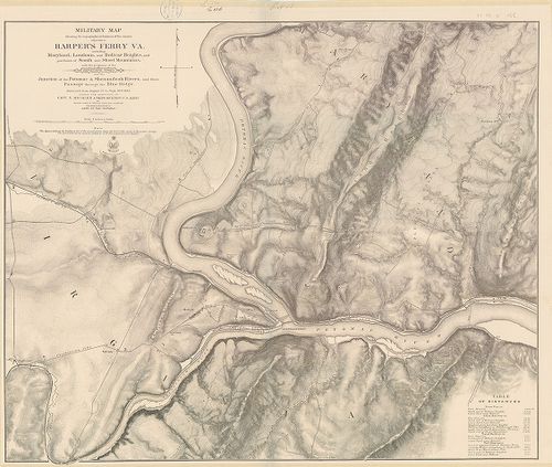
| Title | Military map… Harper’s Ferry Va… 1863. |
| Main title | Harpers Ferry V. (USA) térségének vázlatos térképe, 1863. (Észak-amerikai polgárháború.) Hadállások, kiserődök. Útvonalak. Kimutatás távolságokról. |
371. Fort Sumter. South Carolina, at the time of its capture febr... [H IV c 163]
Institute and Museum of Military History •
H IV c (1841–1913)
•
H IV Újabbkori háborúk
•
H Háborúk
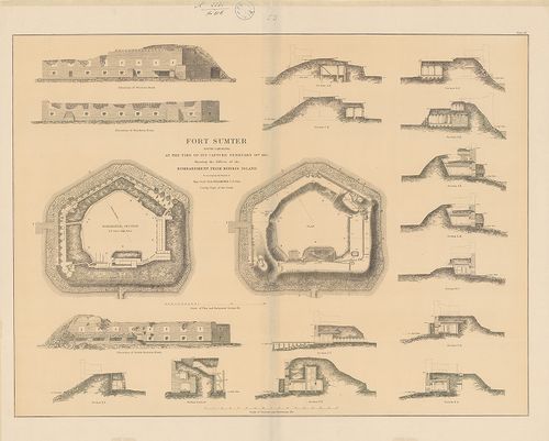
| Title | Fort Sumter. South Carolina, at the time of its capture february 18th 1865. Showing the Effects of teh Bombardment from Morris Island. |
| Main title | Fort Sumter (Dél-Carolina, USA erőd) bevétele után, 1865. 2 alaprajz az erőd védelmi berendezéseiről és 16 metszet a bombázások hatásáról. (Észak-amerikai polgárháború.) |
372. Dänische verschanzte Stellung am Dannewerk zwischen Treene u... [H IV c 210]
Institute and Museum of Military History •
H IV c (1841–1913)
•
H IV Újabbkori háborúk
•
H Háborúk
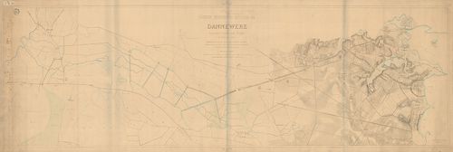
| Title | Dänische verschanzte Stellung am Dannewerk zwischen Treene und Schlei im Feldzuge 1864. |
| Main title | A Dannewerk dán földsánc vázlatos térképe Treene és Schlei között az 1864. évi dán–porosz–osztrák hadjáratok idején. Sáncok, védőállások, kiserődök. Összekötő utak. |
373. Skizze der Eiderlinie und der Danewerke. [H IV c 211]
Institute and Museum of Military History •
H IV c (1841–1913)
•
H IV Újabbkori háborúk
•
H Háborúk
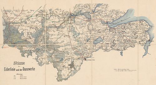
| Title | Skizze der Eiderlinie und der Danewerke. |
| Main title | Schleswig-Holstein egy része Friedrichstadt-Friedrichsort és Schleswig-Rendsburg között. Az Eider-folyó és a Danewerke térsége. Sáncok, útvonalak. |
374. Blick auf die Schanzen No 1., 2., 3., 4. bei Düppel. [H IV c 216]
Institute and Museum of Military History •
H IV c (1841–1913)
•
H IV Újabbkori háborúk
•
H Háborúk
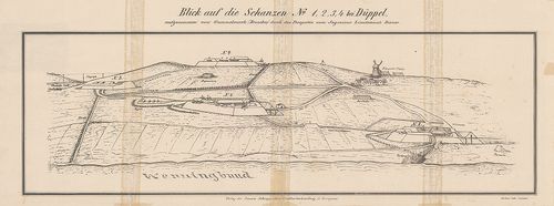
| Title | Blick auf die Schanzen No 1., 2., 3., 4. bei Düppel. |
| Main title | Dybböl (D.) távlati képe (Schleswig.) Sáncok és védőművek a porosz–dán hadjáratban. [1864.]. |
375. Kriegsschlauplatz Nordböhmen 1866. [H IV c 225/1]
Institute and Museum of Military History •
H IV c (1841–1913)
•
H IV Újabbkori háborúk
•
H Háborúk
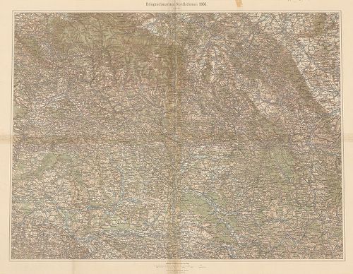
| Title | Kriegsschlauplatz Nordböhmen 1866. |
| Main title | Észak-Csehország mint az 1866. évi porosz–osztrák háború hadszíntere. |
376. [A porosz–osztrák háború, egyes csatái ütközetei 1866. júniu... [H IV c 235]
Institute and Museum of Military History •
H IV c (1841–1913)
•
H IV Újabbkori háborúk
•
H Háborúk
| Title | [A porosz–osztrák háború, egyes csatái ütközetei 1866. június–július.] |
377. Gefechtsfeld von Nachod, Skalitz und Schweinschädel. [H IV c 235/3]
Institute and Museum of Military History •
H IV c (1841–1913)
•
H IV Újabbkori háborúk
•
H Háborúk
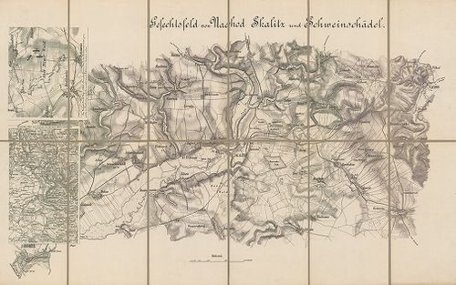
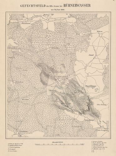
| Title | Gefechtsfeld von Nachod, Skalitz und Schweinschädel. |
| Main title | 2 Mt.: 1. [Hrade-Techlowitz] 2. Übersichts-Plan zum Gefecht von. Nachod. (Náchod környéki csaták.)A Náchod, Skalitz (Česka Skalica) és Schweinschädel (Sviništ’any, Cs.) (1866. évi porosz–osztrák háború.) Útvonalak. |
378. Gefecht von Trautenau am 27. Juni und von Trautenau – Soor a... [H IV c 236/1]
Institute and Museum of Military History •
H IV c (1841–1913)
•
H IV Újabbkori háborúk
•
H Háborúk
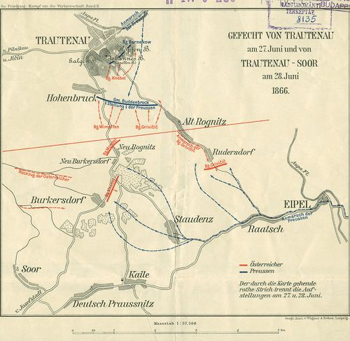
| Title | Gefecht von Trautenau am 27. Juni und von Trautenau – Soor am 28. Juni 1866. |
| Main title | A trautenaui (Trutnov) és a trautenau–soori ütközet vázlatos helyszínrajza 1866. (Csehország. Porosz–osztrák háború.) hadállások, hadmozdulatok. |
379. Anleitung zur Verfassung von Situations und Rekognoszierungs... [H IV c 237/2]
Institute and Museum of Military History •
H IV c (1841–1913)
•
H IV Újabbkori háborúk
•
H Háborúk
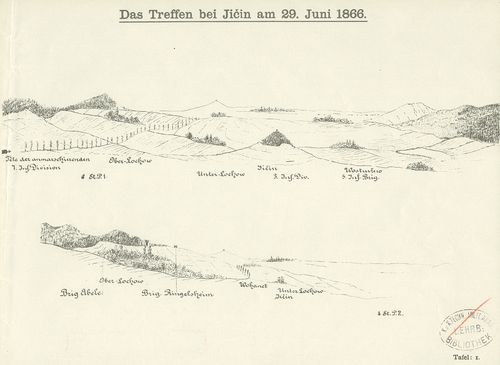
| Title | Anleitung zur Verfassung von Situations und Rekognoszierungs. Skizzen [1866.] |
| Main title | A Königgrätz (Hradec Králové) továbbá a Jičin, Schweinschädel, (Sviništ’any) Skalitz (Česka Skalice) Trautenau (Trutnov) és Wysokow melletti csaták tereptani és harcászati kiértékeléséhez készült látképes terepvázlatok, mint tansegédlet. |
380. Plan zu Schlacht von Königgrätz [H IV c 237/5]
Institute and Museum of Military History •
H IV c (1841–1913)
•
H IV Újabbkori háborúk
•
H Háborúk
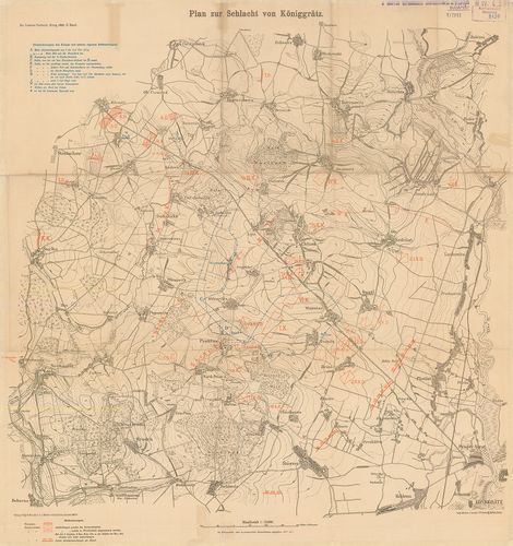
| Title | Plan zu Schlacht von Königgrätz |
| Main title | A königgrätzi (Hradec Králové, Cs.) csata helyszínrajza 1866. Porosz és osztrák hadállások, hadmozdulatok. I. Vilmos porosz király hadinaplójának részletei. |