381. Plan des Gefechtsfeldes von Gitshen (den. 29.–Juni 1866.) [H IV c 237/6]
Institute and Museum of Military History •
H IV c (1841–1913)
•
H IV Újabbkori háborúk
•
H Háborúk
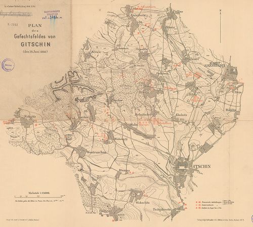
| Title | Plan des Gefechtsfeldes von Gitshen (den. 29.–Juni 1866.) |
| Main title | A gitsheni csata helyszínrajza 1866. Porosz, osztrák, szász hadállások hadmozdulatok. I. Vilmos porosz király hadinaplójának részletei |
382. Nordöstlicher Kriegsschauplatz 1866. [H IV c 237/7]
Institute and Museum of Military History •
H IV c (1841–1913)
•
H IV Újabbkori háborúk
•
H Háborúk
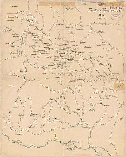
| Title | Nordöstlicher Kriegsschauplatz 1866. |
| Main title | Glogau – Wien – Prága – Troppau közötti térség. Csehország mint az 1866. évi porosz–osztrák háború színtere. |
383. Situation bei Chlum am 3. Juli 1866. gegen 2h30m nachmittags... [H IV c 238/8]
Institute and Museum of Military History •
H IV c (1841–1913)
•
H IV Újabbkori háborúk
•
H Háborúk
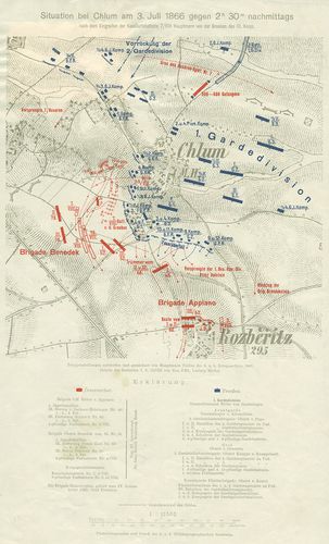
| Title | Situation bei Chlum am 3. Juli 1866. gegen 2h30m nachmittags… |
| Main title | A chlumi (Cs.) csata vázlatos helyszínrajza 1866. (Porosz–osztrák háború Csehországban.) Hadállások, hadmozdulatok. Útvonalak. |
384. Marsch-Routen Karte für die Armee-Corps und Cavallerie-Divis... [H IV c 238/16]
Institute and Museum of Military History •
H IV c (1841–1913)
•
H IV Újabbkori háborúk
•
H Háborúk
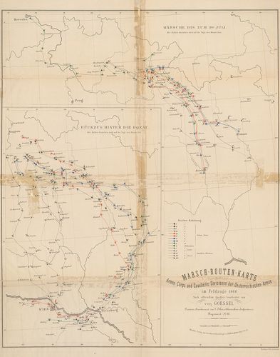
| Title | Marsch-Routen Karte für die Armee-Corps und Cavallerie-Divisionen der Oesterreichischen Armee im Feldzuge 1866. 1. Märsche bis zum 3ten Juli. 2. Rückzug hinter die Donak. |
| Main title | Menettérkép az osztrák hadtestek és lovashadosztályok számára az 1866. évi hadjáratban. Brünn és Königgrätz közötti térség. Visszavonulás a Duna vonala mögé. |
385. Schlacht von Custozza am 24. Juni 1866. [H IV c 249]
Institute and Museum of Military History •
H IV c (1841–1913)
•
H IV Újabbkori háborúk
•
H Háborúk
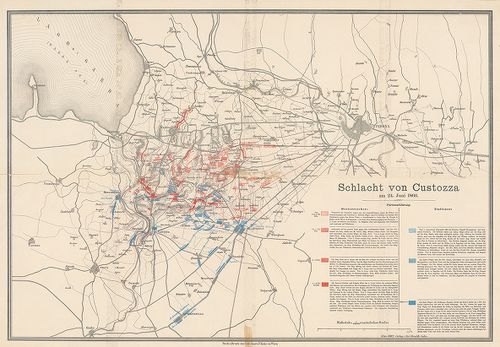
| Title | Schlacht von Custozza am 24. Juni 1866. |
| Main title | A custozzai (Ol.) csata helyszínrajza 1866. Olasz és osztrák hadállások, hadmozdulatok. Útvonalak. |
386. Karte zur Schlacht bei Solfererino 1859 und Custoza 1866. da... [H IV c 249/1a]
Institute and Museum of Military History •
H IV c (1841–1913)
•
H IV Újabbkori háborúk
•
H Háborúk
| Title | Karte zur Schlacht bei Solfererino 1859 und Custoza 1866. dann… |
| Main title | Mt.: Zum Gefecht bei Nogaredo-Versa. (Nogaredo-Versa-i ütközet) A solferinoi (1859) és a custozai (1866) csata térképe. |
387. Karten-Skizze zu den Gefechten bei: Siehrow und Podol – Ošwi... [H IV c 249/1b]
Institute and Museum of Military History •
H IV c (1841–1913)
•
H IV Újabbkori háborúk
•
H Háborúk
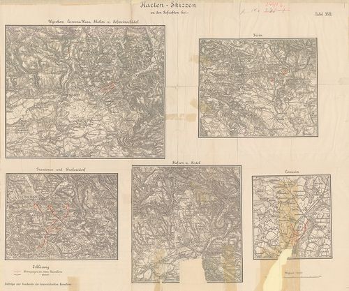
| Title | Karten-Skizze zu den Gefechten bei: Siehrow und Podol – Ošwieçin – Trautenau und Burkerşdorf, Wysokow, Čerwena Hura, Skalitz und Schweinschädel, dann Jičin. |
| Main title | Podol-Ošwiecin-Trutnov-Sviništany- és Jičin melletti csaták térképe. |
388. Das k[aiserliche] k[önigliche] Linien Infanterie Regiment Nr... [H IV c 249/2]
Institute and Museum of Military History •
H IV c (1841–1913)
•
H IV Újabbkori háborúk
•
H Háborúk
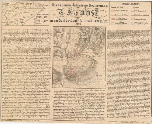
| Title | Das k[aiserliche] k[önigliche] Linien Infanterie Regiment Nr. 48. E[rz] H[erzog] Ernst in der Schlacht bei Custoza (Ol.) am 24. Juni 1866. |
| Main title | Mt.: [Verona (Ol.) környéke.]A cs. kir. Ernő főherceg 48. sz. gyalogezred a custozzai csatában 1866. Custozza és környéke az osztrák és olasz csapatok hadmozdulataival. Részletes ismertetés. A csata 30. évfordulójára 1896. |
389. Plan des Schlachtfeldes von Custoza am 24 Juni 1866. [H IV c 249/4]
Institute and Museum of Military History •
H IV c (1841–1913)
•
H IV Újabbkori háborúk
•
H Háborúk
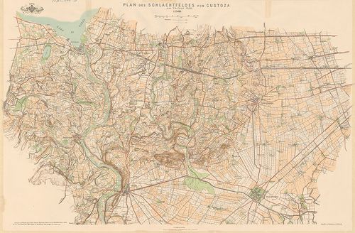
| Title | Plan des Schlachtfeldes von Custoza am 24 Juni 1866. |
| Main title | A custozzai csatatér és környéke (Ol.). |
390. Plan des Schlachtfeldes von Custozza am 24. Juni 1866. („Zu ... [H IV c 250]
Institute and Museum of Military History •
H IV c (1841–1913)
•
H IV Újabbkori háborúk
•
H Háborúk
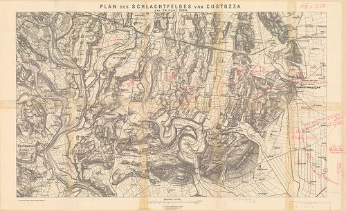
| Title | Plan des Schlachtfeldes von Custozza am 24. Juni 1866. („Zu Oberst von Mathes: Einige taktische Aufgaben”.) |
| Main title | A custozzai csata helyszínrajza (Ol.) 1866. Osztrák és olasz hadállások, hadmozdulatok kézzel bejelölve. |
391. Kampf um Custoza und Monte Torre nach 5h N. [M. (in der Schl... [H IV c 250/1]
Institute and Museum of Military History •
H IV c (1841–1913)
•
H IV Újabbkori háborúk
•
H Háborúk
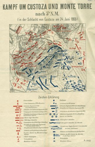
| Title | Kampf um Custoza und Monte Torre nach 5h N. [M. (in der Schlacht von Custoza am 24. Juni 1866.) |
| Main title | A custozzai csata helyszínrajza (Ol.) 1866. Osztrák és olasz hadállások. A csata története a térkép hátlapján. |
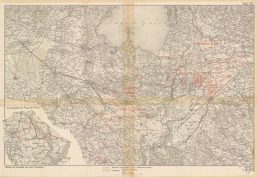
392. Skizzen zur orientirung über den Feldzug 1866 in Italien. (S... [H IV c 250/2]
Institute and Museum of Military History •
H IV c (1841–1913)
•
H IV Újabbkori háborúk
•
H Háborúk
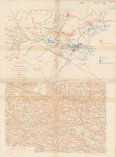
| Title | Skizzen zur orientirung über den Feldzug 1866 in Italien. (Skizze 6.) Taf. XXXIII. |
| Main title | Az olasz–osztrák háború hadállásai és hadmozdulatai Verona távolabbi térségében, 1866. |
393. Der Krieg 1866 in Italien und Südtirol. XI. Spezialkarte der... [H IV c 251/2]
Institute and Museum of Military History •
H IV c (1841–1913)
•
H IV Újabbkori háborúk
•
H Háborúk
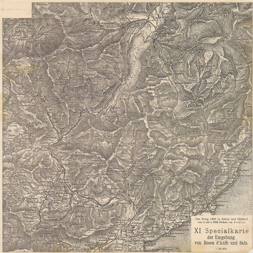
| Title | Der Krieg 1866 in Italien und Südtirol. XI. Spezialkarte der Umgebung von Rocca d’Anfo und Salo. |
| Main title | Rocca d’Anfo és Saló (Ol.) közötti térség az 1866. évi olaszországi hadjáratban. |
394. Der Krieg 1866 in Italien und Südtirol. XII. Specialkarte de... [H IV c 251/3]
Institute and Museum of Military History •
H IV c (1841–1913)
•
H IV Újabbkori háborúk
•
H Háborúk
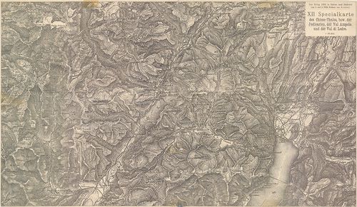
| Title | Der Krieg 1866 in Italien und Südtirol. XII. Specialkarte des Chiese-Thales bzw. der Judicarien, der Val Ampola und der Val di Ledro. |
| Main title | A Chiese-völgy, a Giudicariák, az Ampola és a Ledro-völgy (Ol.) térségének részletes térképe. (Olasz–osztrák háború 1866.) |
395. Angriff der Brigade Waldstätten… [1866.] [H IV c 252/2]
Institute and Museum of Military History •
H IV c (1841–1913)
•
H IV Újabbkori háborúk
•
H Háborúk
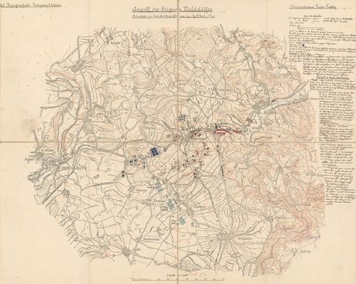
| Title | Angriff der Brigade Waldstätten… [1866.] |
| Main title | Náchod-Wysokow-Skalitz térségében lefolyt ütközet helyszínrajza, 1866. (Porosz–osztrák háború.) Hadállások, hadmozdulatok. A csata két mozzanata. A csata leírása, a tk. szélén. gótb. kézir. (Hadiiskolai dolgozat.) |
396. Topographische Karte der Umgebung von Metz. Die Kriegsoperat... [H IV c 259]
Institute and Museum of Military History •
H IV c (1841–1913)
•
H IV Újabbkori háborúk
•
H Háborúk
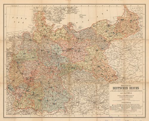
| Title | Topographische Karte der Umgebung von Metz. Die Kriegsoperationen um Metz im Jahre 1870. |
| Main title | Hátl.: Militär-Karte des Deutschen Reichs zur Übersicht des Quartier-Standes und der Landwehr-Inspektions-Bezirke vom 1 April 1890 ab. |
| Subject | Metz [Fr.] körüli csaták 1870. aug. 16., 18., 31.–szept. 1. és 1890-ben.A Német Birodalom katonai kerületi felügyelőség alakulatainak állomáshelyei 1890. április 1-jén. |
397. [Der Feldzug in Frankreich 1870 bis zur Schlacht bei Sedan.] [H IV c 260]
Institute and Museum of Military History •
H IV c (1841–1913)
•
H IV Újabbkori háborúk
•
H Háborúk
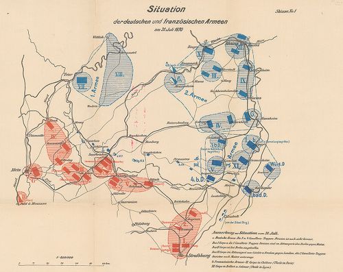
| Title | [Der Feldzug in Frankreich 1870 bis zur Schlacht bei Sedan.] |
| Main title | Franciaországi hadjárat, Sedan melletti csata térképei 1870-ben. |
398. [Der Feldzug in Frankreich 1870–71. II. Teil.] [H IV c 260/1]
Institute and Museum of Military History •
H IV c (1841–1913)
•
H IV Újabbkori háborúk
•
H Háborúk
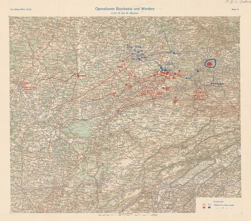
| Title | [Der Feldzug in Frankreich 1870–71. II. Teil.] |
| Main title | Franciaországi hadjárat 1870–71-ben. |
399. Deutsch-Französischer Kriegsschauplatz (Westlich von Paris N... [H IV c 262]
Institute and Museum of Military History •
H IV c (1841–1913)
•
H IV Újabbkori háborúk
•
H Háborúk
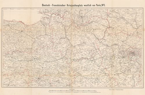
| Title | Deutsch-Französischer Kriegsschauplatz (Westlich von Paris No I–II.) |
| Main title | A német–francia háború hadszíntere Párizstól (Fr.) nyugatra 1870–71. |
400. Übersichtskarte von Nordost-Frankreich in den Jahren 1870–71... [H IV c 262/1]
Institute and Museum of Military History •
H IV c (1841–1913)
•
H IV Újabbkori háborúk
•
H Háborúk
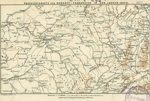
| Title | Übersichtskarte von Nordost-Frankreich in den Jahren 1870–71. |
| Main title | Északkelet-Franciaország áttekintő térképe. (Német–francia háború 1870–71.) |