401. Strassen-Karte der Westlichen Alpen. [B II c 143]
Institute and Museum of Military History •
B II c
•
B II Európa, nagyobb részek és országcsoportok
•
B I–XV. Európa
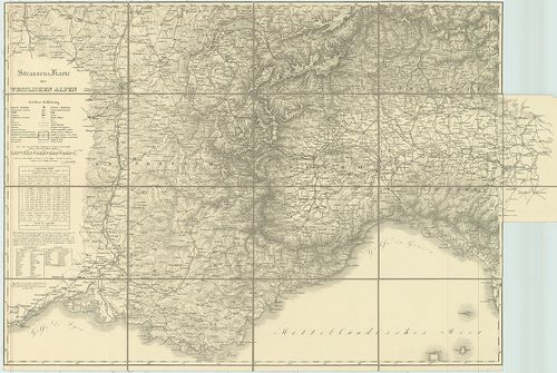
| Title | Strassen-Karte der Westlichen Alpen. |
| Main title | A Nyugati-Alpok úttérképe 1831–32-ben. |
402. Deutsche Herreskarte. [B II c 147]
Institute and Museum of Military History •
B II c
•
B II Európa, nagyobb részek és országcsoportok
•
B I–XV. Európa
| Title | Deutsche Herreskarte. |
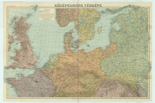
403. Vogels Karte von Mitteleuropa. Übersichtsblatt Fliegerkarte. [B II c 148]
Institute and Museum of Military History •
B II c
•
B II Európa, nagyobb részek és országcsoportok
•
B I–XV. Európa
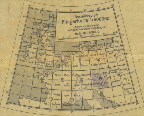
| Title | Vogels Karte von Mitteleuropa. Übersichtsblatt Fliegerkarte. |
| Main title | Közép-Európa áttekintő térképe. |
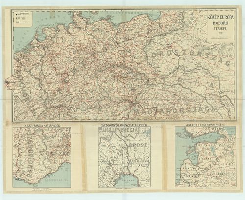
404. Közép-Európa háború térképe. [B II c 149]
Institute and Museum of Military History •
B II c
•
B II Európa, nagyobb részek és országcsoportok
•
B I–XV. Európa
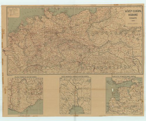
| Title | Közép-Európa háború térképe. |
| Main title | 3 mt.: Kül. m.: 1. Olasz–francia határvidék. 2. Svéd–norvég–orosz határvidék. 3. A Keleti-tenger partvidéke. |
405. Carte de la Mer Méditerranée – dressé pour le voyage de Mr. ... [B II c 150]
Institute and Museum of Military History •
B II c
•
B II Európa, nagyobb részek és országcsoportok
•
B I–XV. Európa
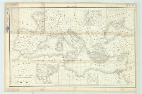
| Title | Carte de la Mer Méditerranée – dressé pour le voyage de Mr. de Chateaubriand |
| Main title | 3 mt.: 1. Anatólia. 2. Szíria. 3. Peloponészosz-fsz. |
| Subject | A Földközi-tenger medencéje térképe Mr. Chateaubriand utazásához. |
406. Post Charte der Österreichisch-Teutschen Preussischen u. Teu... [B II c 151]
Institute and Museum of Military History •
B II c
•
B II Európa, nagyobb részek és országcsoportok
•
B I–XV. Európa
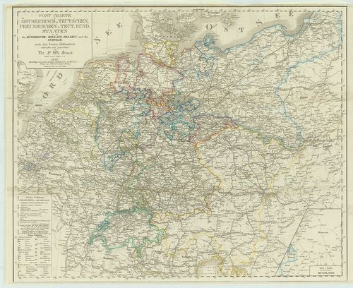
| Title | Post Charte der Österreichisch-Teutschen Preussischen u. Teut. Bund. Staaten. so wie der Königreiche Holland, Belgien und der Schweiz. |
| Main title | 1 mt. [Északkelet Oroszország.] |
| Subject | Német és Porosz Szövetségi városok postaútjai és holland, belga svájci városok. |
407. A nyugati harctér. [B II c 152]
Institute and Museum of Military History •
B II c
•
B II Európa, nagyobb részek és országcsoportok
•
B I–XV. Európa
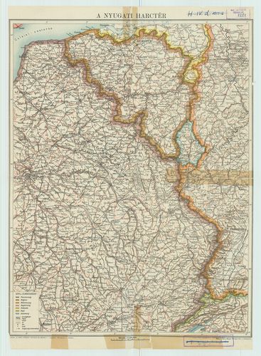
| Title | A nyugati harctér. |
408. Grosse Handkarte der Grenzländer Österreich–Ungarn Italien. [B II c 153]
Institute and Museum of Military History •
B II c
•
B II Európa, nagyobb részek és országcsoportok
•
B I–XV. Európa
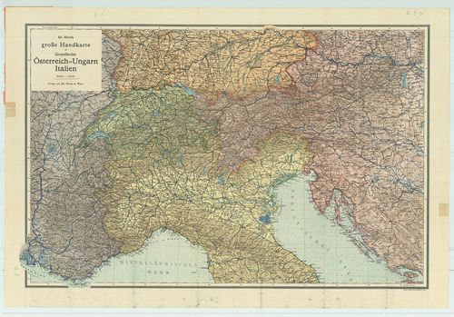
| Title | Grosse Handkarte der Grenzländer Österreich–Ungarn Italien. |
| Main title | Az osztrák–magyar-olasz határterület térképe. |
409. Karte des östlichen Kriegsschauplätze mit Darstellung von Kr... [B II c 154]
Institute and Museum of Military History •
B II c
•
B II Európa, nagyobb részek és országcsoportok
•
B I–XV. Európa
| Title | Karte des östlichen Kriegsschauplätze mit Darstellung von Kriegs-Ereignissen. |
| Main title | 2 mt.: 1.) Türkisch-russischer Kriegssehauplatz. (Török–orosz hadszíntér.) 2.) Türkisch-englischer Kriegsschauplatz. (Angol–török hadszíntér.) |
| Subject | A keleti hadszíntér áttekintő térképe. |
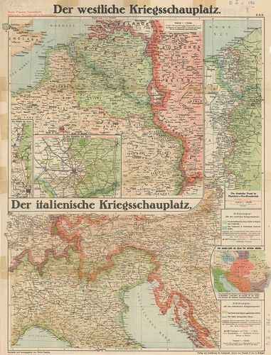
410. 1.) Westlicher Kriegsschauplatz. [B II c 155]
Institute and Museum of Military History •
B II c
•
B II Európa, nagyobb részek és országcsoportok
•
B I–XV. Európa
| Title | 1.) Westlicher Kriegsschauplatz. |
| Main title | 2.) Italienischer Kriegsschau-platz. |
| Subject | 1.) A nyugati hadszíntér. 2. Az északi-olasz hadszíntér. |
411. Eisenbahnkarte von Deutschland und Österreich–Ungarn. [B II c 156]
Institute and Museum of Military History •
B II c
•
B II Európa, nagyobb részek és országcsoportok
•
B I–XV. Európa
| Title | Eisenbahnkarte von Deutschland und Österreich–Ungarn. |
| Main title | Németország és Ausztria–Magyarország vasúti térképe. |
412. Karte der Österreichisch–Russischen grenzgebiete. [B II c 157]
Institute and Museum of Military History •
B II c
•
B II Európa, nagyobb részek és országcsoportok
•
B I–XV. Európa
| Title | Karte der Österreichisch–Russischen grenzgebiete. |
| Main title | Az osztrák–orosz határvidék térképe. |
413. Westlicher Kriegsschauplatz. – Südwestlicher Kriegsschauplat... [B II c 158]
Institute and Museum of Military History •
B II c
•
B II Európa, nagyobb részek és országcsoportok
•
B I–XV. Európa
| Title | Westlicher Kriegsschauplatz. – Südwestlicher Kriegsschauplatz. |
| Main title | Oestlicher Kriegsschauplatz. – Südöstlicher Kriegsschauplatz. |
| Subject | Mt. Die Vogesen. Hátlapon 8 térkép eseménynapló a többi front hadihelyzetéről. Parancsnokok arcképei. |
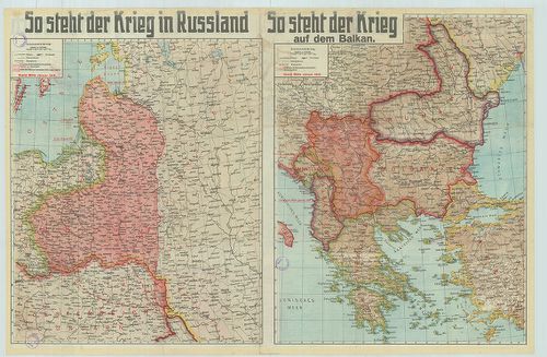
414. So sthet der Krieg in Russland. – So steht der Krieg auf dem... [B II c 159]
Institute and Museum of Military History •
B II c
•
B II Európa, nagyobb részek és országcsoportok
•
B I–XV. Európa
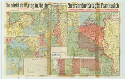
| Title | So sthet der Krieg in Russland. – So steht der Krieg auf dem Balkan. |
| Main title | 1.) So steht der Krieg in Italien. 2.) So steht der Krieg in Frankreich. 12 térkép az olasz–török–francia front hadihelyzetéről. |
| Subject | Az orosz és balkáni hadszíntér 1915-ben. |
415. Westlicher Kriegsschauplatz 1914–15. [B II c 160]
Institute and Museum of Military History •
B II c
•
B II Európa, nagyobb részek és országcsoportok
•
B I–XV. Európa
| Title | Westlicher Kriegsschauplatz 1914–15. |
| Main title | 2 mt.: 1.) Paris und seine befestigungen. (Párizs és környéke.) 2. Metz és környéke. |
| Subject | Östlicher Kriegsschauplatz. 4 térkép több front hadihelyzetéről. |
416. Dietrich Reimer’s kriegsstandskarten. Politische Übersicht. [B II c 161]
Institute and Museum of Military History •
B II c
•
B II Európa, nagyobb részek és országcsoportok
•
B I–XV. Európa
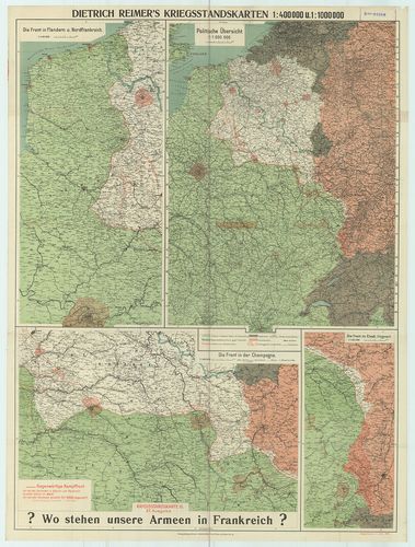
| Title | Dietrich Reimer’s kriegsstandskarten. Politische Übersicht. |
| Main title | 3 mt.: 1.) Die front im Flandern u. Nordfrankreich. |
| Subject | 2.) Die Front in der Champagne. |
417. Az északi hadszíntér madártávlati térképe. [B II c 162]
Institute and Museum of Military History •
B II c
•
B II Európa, nagyobb részek és országcsoportok
•
B I–XV. Európa
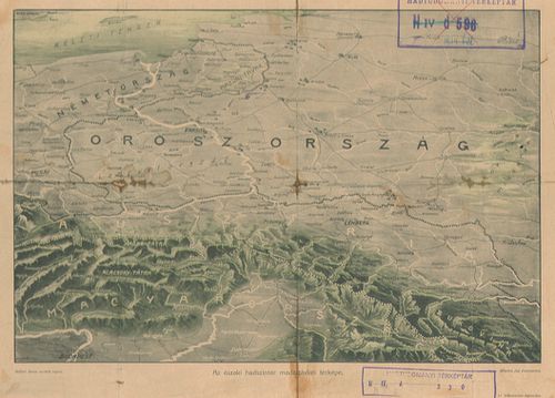
| Title | Az északi hadszíntér madártávlati térképe. |
418. Der östliche Kriegsschauplatz aus der Vogelschau. [B II c 163]
Institute and Museum of Military History •
B II c
•
B II Európa, nagyobb részek és országcsoportok
•
B I–XV. Európa
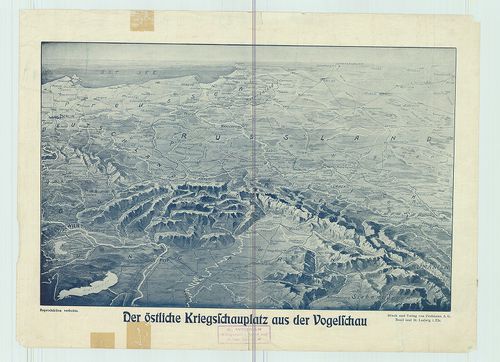
| Title | Der östliche Kriegsschauplatz aus der Vogelschau. |
| Main title | A keleti hadszíntér madártávlatból. |
419. A világháború térképe. [Közép-Európa.] [B II c 164]
Institute and Museum of Military History •
B II c
•
B II Európa, nagyobb részek és országcsoportok
•
B I–XV. Európa
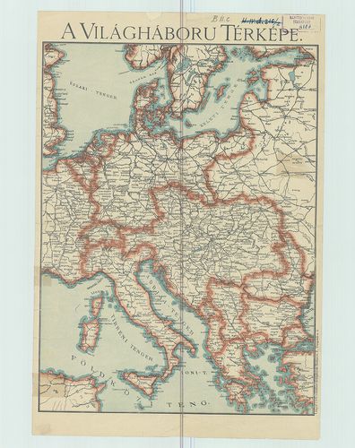
| Title | A világháború térképe. [Közép-Európa.] |
420. A világháború térképe. [Közép-Európa.] [B II c 165]
Institute and Museum of Military History •
B II c
•
B II Európa, nagyobb részek és országcsoportok
•
B I–XV. Európa
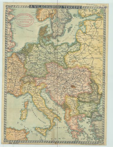
| Title | A világháború térképe. [Közép-Európa.] |
421. Lo scacchiere russo–austro–tedesco 2° supplemento alla carta... [B II c 166]
Institute and Museum of Military History •
B II c
•
B II Európa, nagyobb részek és országcsoportok
•
B I–XV. Európa

| Title | Lo scacchiere russo–austro–tedesco 2° supplemento alla carta del teatro della guerra. |
| Main title | Mt.: Memel-vidéke. |
| Subject | Az orosz–osztrák–német hadszíntér. |
422. Középeurópa háború térképe. [B II c 167]
Institute and Museum of Military History •
B II c
•
B II Európa, nagyobb részek és országcsoportok
•
B I–XV. Európa
| Title | Középeurópa háború térképe. |
423. Közép Európa háború térképe. [B II c 169]
Institute and Museum of Military History •
B II c
•
B II Európa, nagyobb részek és országcsoportok
•
B I–XV. Európa
| Title | Közép Európa háború térképe. |
| Main title | 3 mt.: 1.) Olasz–Francia határvidék. |
| Subject | 2.) Svéd–norvég–orosz határvidék. |
424. Selyemre nyomott amerikai navigációs térk.: 1. old. Balkán-f... [B II c 176]
Institute and Museum of Military History •
B II c
•
B II Európa, nagyobb részek és országcsoportok
•
B I–XV. Európa
| Title | Selyemre nyomott amerikai navigációs térk.: 1. old. Balkán-fsz. (Albánia, Bulgária, Görögország, Töröko.) térképe M. 1:1 750 000 2. old. (Olaszország és a Balkán-fsz.) Jugo., Albánia, Románia, Bulgária, Görögo., Töröko., Magyarország) térképe M. 1:3 000 000. |
425. Mistopisna a Železnični Mapa Nastupnických státu. [B II c 177]
Institute and Museum of Military History •
B II c
•
B II Európa, nagyobb részek és országcsoportok
•
B I–XV. Európa
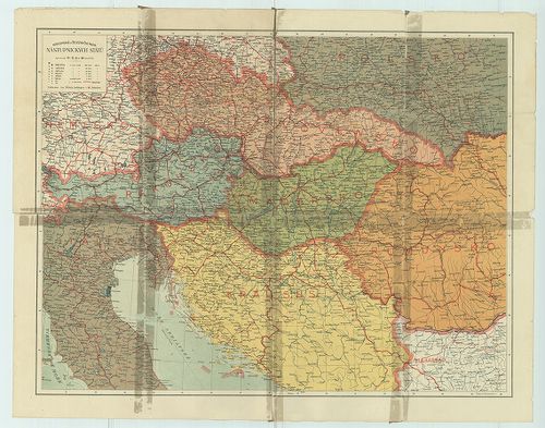
| Title | Mistopisna a Železnični Mapa Nastupnických státu. |
| Main title | Helyszín az I. világháború után sz Osztrák-Magyar Monarchia utódállamairól, fontosabb útvonalak feltüntetésével,. |
426. Übersichtskarte von Europa. [B II c 178]
Institute and Museum of Military History •
B II c
•
B II Európa, nagyobb részek és országcsoportok
•
B I–XV. Európa
| Title | Übersichtskarte von Europa. |
| Main title | Áttekintő térkép Európáról. |
427. Post- und Eisenbahn-Reisehorte von General-Europa. [B II c 179]
Institute and Museum of Military History •
B II c
•
B II Európa, nagyobb részek és országcsoportok
•
B I–XV. Európa
| Title | Post- und Eisenbahn-Reisehorte von General-Europa. |
| Main title | Közép-Európa posta-, vasút és útitérképe. |
428. Guerra Italo–Austriaca 1915–16. Carta d’Italia e Regioni Lim... [B II c 180]
Institute and Museum of Military History •
B II c
•
B II Európa, nagyobb részek és országcsoportok
•
B I–XV. Európa
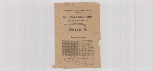
| Title | Guerra Italo–Austriaca 1915–16. Carta d’Italia e Regioni Limitrofe. |
| Main title | Ausztria, Jugoszlávia, Olaszország határtérképe. |
429. Carta Corografica D’ Italia. [B II c 181]
Institute and Museum of Military History •
B II c
•
B II Európa, nagyobb részek és országcsoportok
•
B I–XV. Európa
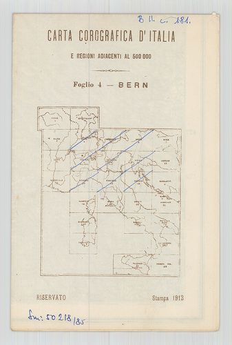
| Title | Carta Corografica D’ Italia. |
| Main title | 4.) Bern, 5.) München, 6.) Graz, 9. Torino–Milano. 10.) Venezia, 11.) Udine, 14.) Genova, 15.) Firenze, 16.) Ancona. |
430. Allemagne et pays Limitrophes. Deutschland und Nachbarlander... [B II c 182]
Institute and Museum of Military History •
B II c
•
B II Európa, nagyobb részek és országcsoportok
•
B I–XV. Európa
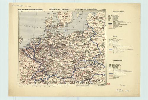
| Title | Allemagne et pays Limitrophes. Deutschland und Nachbarlander. |
| Main title | Németország és a szomszédos országok. Közép-Európa határai 1940-ben. Permanent atlaszlap N3. |
431. Ravenstein-Liebenow's Special Rad- und Automobilkarte von Mi... [B II c 184]
Institute and Museum of Military History •
B II c
•
B II Európa, nagyobb részek és országcsoportok
•
B I–XV. Európa
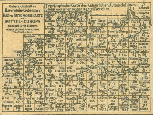
| Title | Ravenstein-Liebenow's Special Rad- und Automobilkarte von Mittel-Európa. |
| Main title | Közép-Európa kerékpár- és úttérképe. Áttekintő szerint. |
432. So steht der Krieg in Russland. So steht der Krieg auf dem B... [B II c 185]
Institute and Museum of Military History •
B II c
•
B II Európa, nagyobb részek és országcsoportok
•
B I–XV. Európa
| Title | So steht der Krieg in Russland. So steht der Krieg auf dem Balkan. |
| Main title | So steht der Krieg im Orient. So steht der Krieg in Frankreich. So steht der Krieg in Italien + 4 mt.: a frontokról. |
| Subject | Az orosz és balkáni hadszíntér 1916-ban. |
433. Paasche's Frontenkarte. Der Westliche Kriegsschauplatz. A há... [B II c 186]
Institute and Museum of Military History •
B II c
•
B II Európa, nagyobb részek és országcsoportok
•
B I–XV. Európa
| Title | Paasche's Frontenkarte. Der Westliche Kriegsschauplatz. A hátoldalon: Der Krieg gegen Russland... |
| Main title | A nyugati hadszíntér; A háború Oroszországban, Az olaszországi hadszíntér, az I. világháború hadszínterei, követve az I. világháború időszakát 1915-1918 között. |
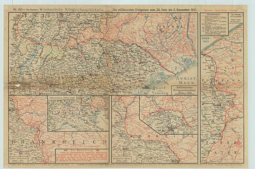
434. Kriegskarte. Nr. 62. Die militär. Ereignisse V. 6. bis 13. D... [B II c 187]
Institute and Museum of Military History •
B II c
•
B II Európa, nagyobb részek és országcsoportok
•
B I–XV. Európa
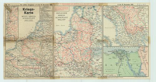
| Title | Kriegskarte. Nr. 62. Die militär. Ereignisse V. 6. bis 13. Dezember 1915. |
| Main title | Az I. világháború erőhadszínterei 1915. dec. 6–13. között. |
435. Möchentliche Kriegsshauplatz-Karte mit Chronik. Die militäri... [B II c 188]
Institute and Museum of Military History •
B II c
•
B II Európa, nagyobb részek és országcsoportok
•
B I–XV. Európa
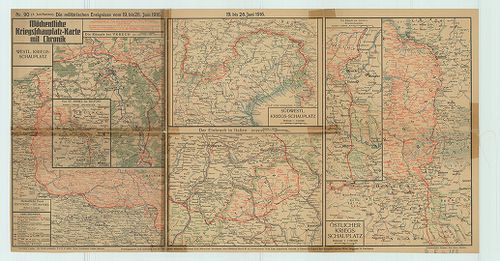
| Title | Möchentliche Kriegsshauplatz-Karte mit Chronik. Die militärischen Ereignisse vom 19. bis 26. Juni 1916. |
| Main title | Az I. világháború első hadszínterei 1916. június 19–26. |
436. Kriegskarte. Nr. 49. 1915. szept. 6–13. [B II c 189]
Institute and Museum of Military History •
B II c
•
B II Európa, nagyobb részek és országcsoportok
•
B I–XV. Európa
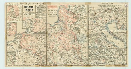
| Title | Kriegskarte. Nr. 49. 1915. szept. 6–13. |
| Main title | Térképek az I. világháború hadszíntereiről 1915. szept. 6–13. között. A hátl. szöv. megírás. |
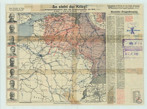
437. So Steht jetzt de Krieg! [B II c 190]
Institute and Museum of Military History •
B II c
•
B II Európa, nagyobb részek és országcsoportok
•
B I–XV. Európa
| Title | So Steht jetzt de Krieg! |
| Main title | Az I. világháború hadszínterei 1915-ben. |
438. Paasche’s Spezialkarten der Westfront. Blatt. 1. Ypern (kézz... [B II c 191]
Institute and Museum of Military History •
B II c
•
B II Európa, nagyobb részek és országcsoportok
•
B I–XV. Európa
| Title | Paasche’s Spezialkarten der Westfront. Blatt. 1. Ypern (kézzel rárajzolt tartalommal). Blatt 2. Lille–La Bassée. + szöveges leírás. Blatt 3a. Bapaume (1916). Blatt 3b. Cambrai (1917). Blatt 4a. Roye-Noyon (1916). Blatt 4b. St. Quentin (1917). Blatt 5. Soissons (rárajzolt tartalommal, 2 féle). Blatt 6. Reims (2 féle, 1915, 1917). Blatt 8. St. Mihiel. Blatt 9. Château Salins. Blatt 10. Lunéville. Blatt 11. Colmar. Blatt 12. Belfort-Mülhausen. |
| Main title | Paasche részletes térképe a nyugati hadszíntérről (német–francia frontvonal) az I. világháborúban. |
439. England und die französischen–belgischen Kanalküsten. Flemmi... [B II c 192]
Institute and Museum of Military History •
B II c
•
B II Európa, nagyobb részek és országcsoportok
•
B I–XV. Európa

| Title | England und die französischen–belgischen Kanalküsten. Flemmings Kriegskarte. Nr. 14. |
| Main title | 2 mt.: 1.) Plan von London. |
| Subject | 2.) Der Weg von Continent nach England. |
440. G. Freytags Übersichtskarte des Deutsch–Französischen Kriegs... [B II c 193]
Institute and Museum of Military History •
B II c
•
B II Európa, nagyobb részek és országcsoportok
•
B I–XV. Európa
| Title | G. Freytags Übersichtskarte des Deutsch–Französischen Kriegsschauplatzes. |
| Main title | A német–francia hadszíntér az I. világháború idején. |
441. Bereiche der Feldtransportleitungen in Österreich–Ungarn und... [B II c 194]
Institute and Museum of Military History •
B II c
•
B II Európa, nagyobb részek és országcsoportok
•
B I–XV. Európa
| Title | Bereiche der Feldtransportleitungen in Österreich–Ungarn und der anschliessenden deutschen Linienkommandanturen. |
| Main title | Az Osztrák–Magyar Monarchia harctéri szállítási útvonalainak a területe és a csatlakozó német vonalparancsnokságok. |
442. Germany. Map of the occupation areas. [B II c 197]
Institute and Museum of Military History •
B II c
•
B II Európa, nagyobb részek és országcsoportok
•
B I–XV. Európa
| Title | Germany. Map of the occupation areas. |
| Main title | Németország. A megszállási övezetek térképe 1945-ben. |
443. Map of the occupation areas. [B II c 198]
Institute and Museum of Military History •
B II c
•
B II Európa, nagyobb részek és országcsoportok
•
B I–XV. Európa
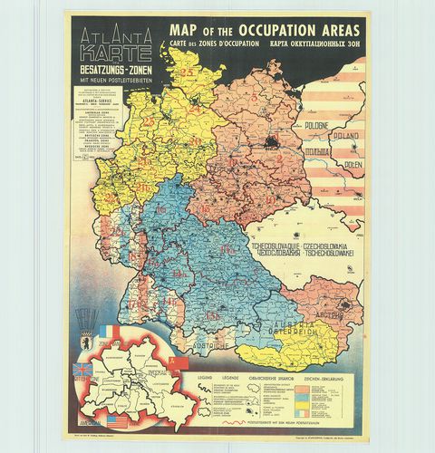
| Title | Map of the occupation areas. |
| Main title | A megszállási övezetek térképe 1945-ben. |
444. Mittel-Eurpa (von Paris bis Petersburg vom kattegat bis Vene... [B II c 200]
Institute and Museum of Military History •
B II c
•
B II Európa, nagyobb részek és országcsoportok
•
B I–XV. Európa
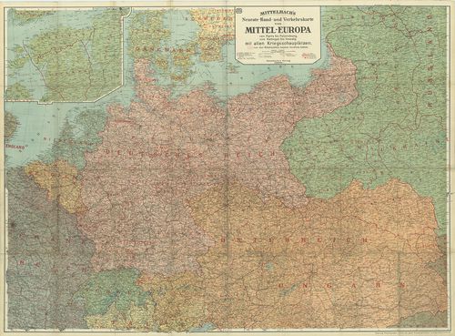
| Title | Mittel-Eurpa (von Paris bis Petersburg vom kattegat bis Venedig) mit allen Kriegsschauplatzen. |
| Main title | 1 mt.: a Finn öböl. |
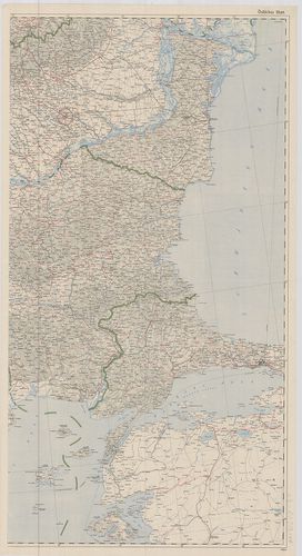
| Subject | Közép-Európa (Párizstól Pétervárig, Kattegattól Velencéig) hadszínterei (és a megszált területek) 1915. |
445. Südeuropa Ostblatt. Sträßenkarte. [B II c 201]
Institute and Museum of Military History •
B II c
•
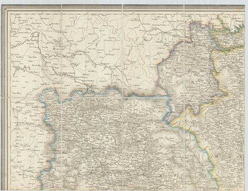
B II Európa, nagyobb részek és országcsoportok
•
B I–XV. Európa
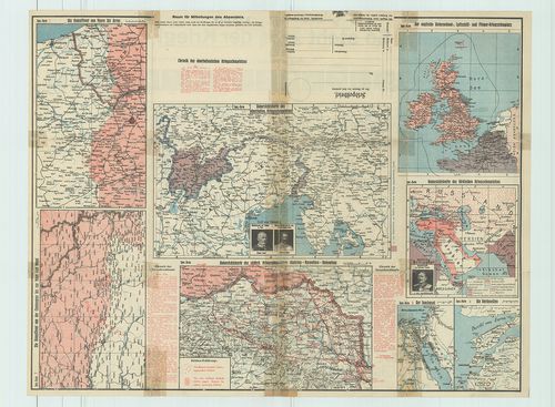
| Title | Südeuropa Ostblatt. Sträßenkarte. |
| Main title | Dél-Európa (K-i szelvény) úttérképe. |
446. Bradshaw’s Railway Map of Central Europe. [B II c 204]
Institute and Museum of Military History •
B II c
•
B II Európa, nagyobb részek és országcsoportok
•
B I–XV. Európa
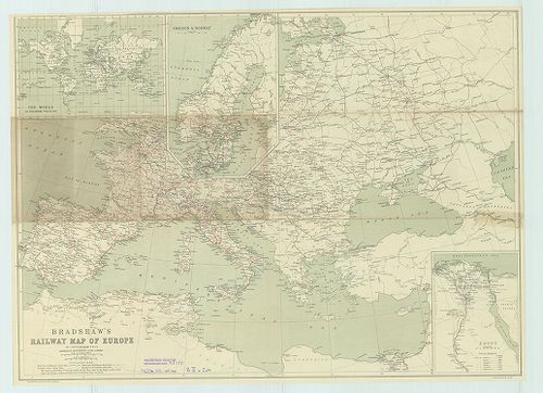
| Title | Bradshaw’s Railway Map of Central Europe. |
| Main title | Közép-Európa vasúti térképe. |
447. Ostalpenländer. [B II c 205]
Institute and Museum of Military History •
B II c
•
B II Európa, nagyobb részek és országcsoportok
•
B I–XV. Európa
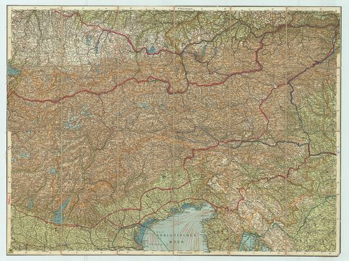
| Title | Ostalpenländer. |
| Main title | A Keleti Alpok autótérképe. |
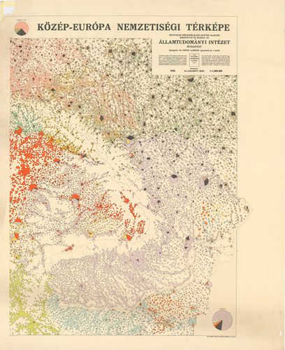
448. Közép-Európa nemzetiségi térképe. [B II c 207]
Institute and Museum of Military History •
B II c
•
B II Európa, nagyobb részek és országcsoportok
•
B I–XV. Európa
| Title | Közép-Európa nemzetiségi térképe. |
449. Etnographische Karte von Mitteleuropa. [B II c 208]
Institute and Museum of Military History •
B II c
•
B II Európa, nagyobb részek és országcsoportok
•
B I–XV. Európa
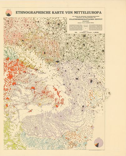
| Title | Etnographische Karte von Mitteleuropa. |
| Main title | Közép-Európa nemzetiségi térképe, németül |
450. Etnographical Map of Central Europe. [B II c 209]
Institute and Museum of Military History •
B II c
•
B II Európa, nagyobb részek és országcsoportok
•
B I–XV. Európa
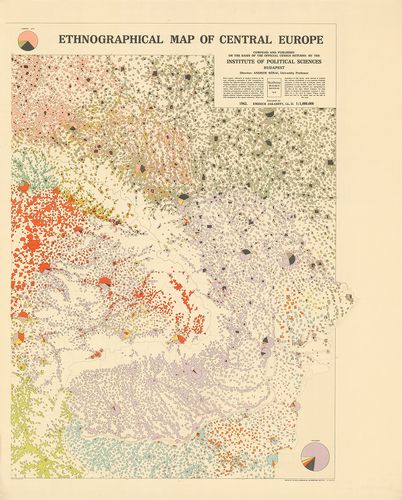
| Title | Etnographical Map of Central Europe. |
| Main title | Közép-Európa nemzetiségi térképe, angolul. |
451. Carte Etnographique de l´Europa Centrale. [B II c 210]
Institute and Museum of Military History •
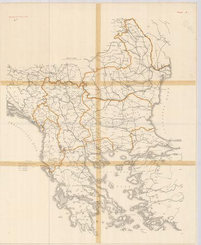
B II c
•
B II Európa, nagyobb részek és országcsoportok
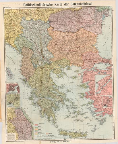
•
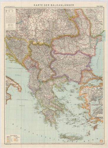
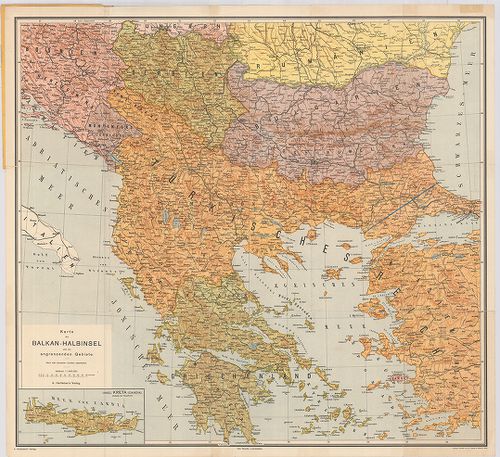
B I–XV. Európa
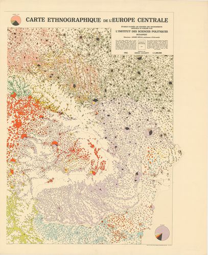
| Title | Carte Etnographique de l´Europa Centrale. |
| Main title | Közép-Európa nemzetiségi térképe, franciául. |
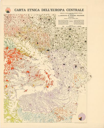
452. Carta Etnica dell´Europa Centrale. [B II c 211]
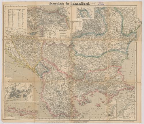
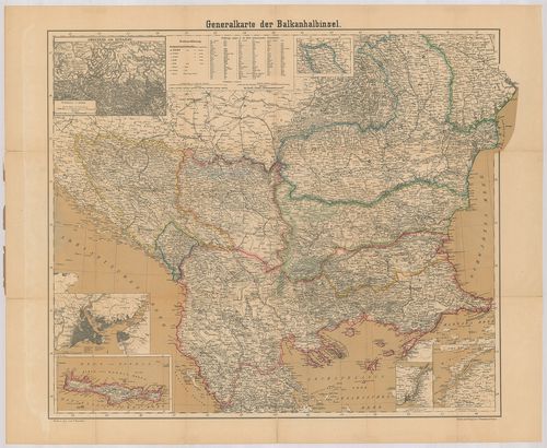
Institute and Museum of Military History •
B II c
•
B II Európa, nagyobb részek és országcsoportok
•
B I–XV. Európa
| Title | Carta Etnica dell´Europa Centrale. |
| Main title | Közép-Európa nemzetiségi térképe, olaszul. |
453. Bereiche der Feldtransportleitungen, der Eisenbahnlinien kom... [B II c 212]
Institute and Museum of Military History •
B II c
•
B II Európa, nagyobb részek és országcsoportok
•
B I–XV. Európa
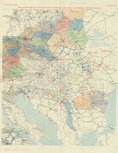
| Title | Bereiche der Feldtransportleitungen, der Eisenbahnlinien kommandos mit selbständiger Instradierungsbefugnis und der anschliessenden deutschen Linienkommandaturen. |
| Main title | A központi hatalmak katonai szállításvezetőségeinek hálózati térképe 1918. máj. |
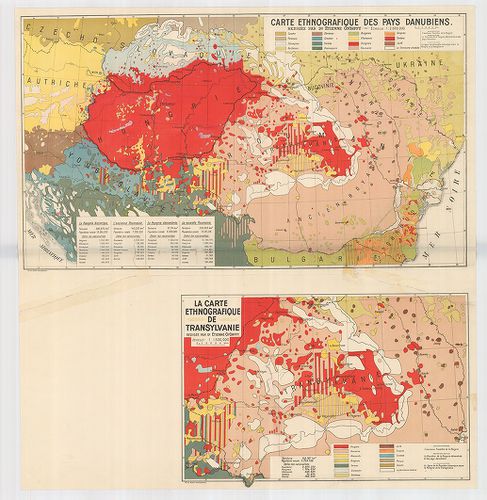
454. Carte Ethnographique des pays Danubiens. [B II c 213]
Institute and Museum of Military History •
B II c
•
B II Európa, nagyobb részek és országcsoportok
•
B I–XV. Európa
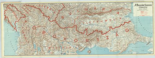
| Title | Carte Ethnographique des pays Danubiens. |
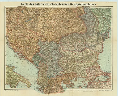
| Main title | Mt. La Carte Ethnographique de Transylvanie. (Erdély néprajzi térképe. |
| Subject | A Duna-medence néprajzi térképe 1928 körül. |
455. Kriegskarte. Nr. 165. Die militär. Ereignisse von 26. Nov. b... [B II c 214]
Institute and Museum of Military History •
B II c
•
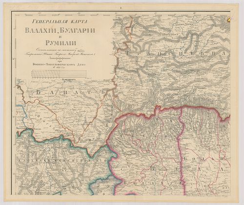
B II Európa, nagyobb részek és országcsoportok
•
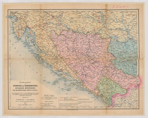
B I–XV. Európa
| Title | Kriegskarte. Nr. 165. Die militär. Ereignisse von 26. Nov. bis 5. Dezember 1917. |
| Main title | Térképek az I. világháború hadszíntereiről 1917. nov. 26ésdec. 5. között. |
456. Az orosz harctér. A front állása: 1915. május 1-én. 1916. jú... [B II c 215]
Institute and Museum of Military History •
B II c
•
B II Európa, nagyobb részek és országcsoportok
•
B I–XV. Európa
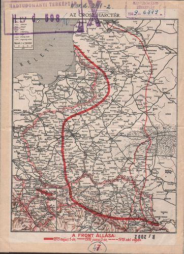
| Title | Az orosz harctér. A front állása: 1915. május 1-én. 1916. június 1.-én. 1916. október végén. A hátoldalon: Az olasz harctér. A nyugati harctér. A balkáni harctér. |
457. Neueste Karte der Koenigreiche Bosnien, Servien, Croatien un... [B III a 1]
Institute and Museum of Military History •
B III a
•
B III Balkán-félsziget
•
B I–XV. Európa
| Title | Neueste Karte der Koenigreiche Bosnien, Servien, Croatien und Slavonien… einem grossen Theil von Ungarn, Siebenbürgen, Wallachei, Bulgarien, Albanien, Macedonien. … |
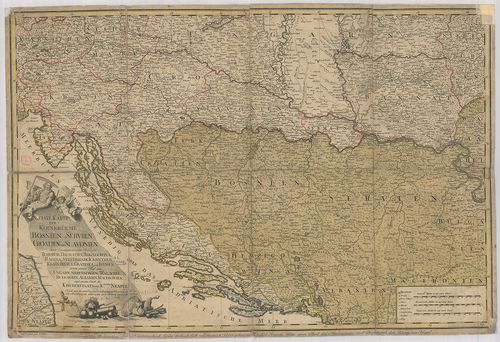
| Main title | Bosznia, Szerbia, Horvát-Szlavónia térképe 1788-ban. |
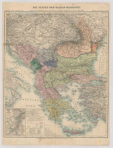
458. Die Staten der Balkan-Halbinsel nach den Grenzbestimmungen d... [B III a 2]
Institute and Museum of Military History •
B III a
•
B III Balkán-félsziget
•
B I–XV. Európa
| Title | Die Staten der Balkan-Halbinsel nach den Grenzbestimmungen des Friedens von Hagios Stephano (St. Stefano). |
| Main title | Mt.: Constantinopel und der Bosporus. (Istanbul és a Boszporusz.)A Balkán-félsziget 1878. márc. 2-i St. Stefanoi béke utáni határ kijelölésének térképe. (Bulgária 1878 utáni határát piros ceruzával jelölték.) |
459. Kommunikationskarte von Serbien. [B III a 3]
Institute and Museum of Military History •
B III a
•
B III Balkán-félsziget
•
B I–XV. Európa
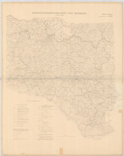
| Title | Kommunikationskarte von Serbien. |
| Main title | Szerbia közlekedési térképe 1905-ben. |
460. Politisch-militärische Karte der Balkan-Halbinsel. Auf Grund... [B III a 3/1]
Institute and Museum of Military History •
B III a
•
B III Balkán-félsziget
•
B I–XV. Európa
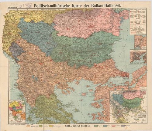
| Title | Politisch-militärische Karte der Balkan-Halbinsel. Auf Grundlage von Karten aus Stielers Handatlas von C. Vogel und B. Domann. |
| Main title | 6 mt. 1. [Katonai egységek elhelyezési tábl.] 2. Der Bosporus. 3. Konstantinopel. (Istanbul.) 4. Strasse der Dardanelle. (Dardanellák.) 5. Anliederung der Volkschulwesens in der heutigen Türkei an die Staatssprachen der christlichen Balkanstaaten (nach von Mach.) (A törökországi népiskolák állapota a keresztény balkáni államok nyelvi tagozódása szerint. 6. Der Rückengang des Osmanischen Reiches in Europa. (A török birodalom visszaszorulása Európában.)A Balkán-félszigeten elhelyezkedő katonai egységek fegyvernemenként és államonként a Stieler atlasz alapján. |
461. Karte der Balkan Halbinsel und der angränzenden Gebiete. [B III a 3/2]
Institute and Museum of Military History •
B III a
•
B III Balkán-félsziget
•
B I–XV. Európa
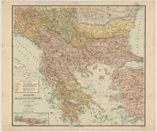
| Title | Karte der Balkan Halbinsel und der angränzenden Gebiete. |
| Main title | Mt.: Insel Kreta. (Candia. |
| Subject | A Balkán-félsziget és a határos területek térképe. |
462. Nuova Carta Topografica della provincia di Dalmazia divisa n... [B III a 4]
Institute and Museum of Military History •
B III a
•
B III Balkán-félsziget
•
B I–XV. Európa
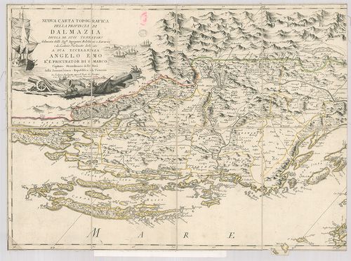
| Title | Nuova Carta Topografica della provincia di Dalmazia divisa ne suoi Territori. |
| Main title | Dalmácia térképe 1787-ben. |
463. Balkan-Halbinsel. [B III a 4/1]
Institute and Museum of Military History •
B III a
•
B III Balkán-félsziget
•
B I–XV. Európa
| Title | Balkan-Halbinsel. |
| Main title | A Balkán-félsziget térképe. |
464. Exactissima Ducatus Carniolae Vinidorum Marchiä et Historiae... [B III a 4/2]
Institute and Museum of Military History •
B III a
•
B III Balkán-félsziget
•
B I–XV. Európa
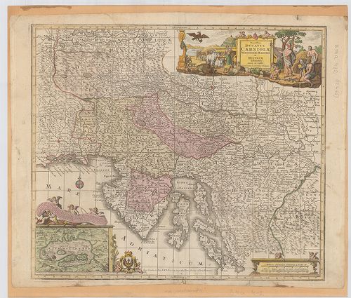
| Title | Exactissima Ducatus Carniolae Vinidorum Marchiä et Historiae. |
| Main title | Karniola és az Isztria-félsziget térképe a 18. század közepén. |
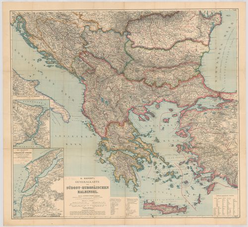
465. Generalkarte der Südost-Europäischen Halbinsel – Unter Donau... [B III a 5/2]
Institute and Museum of Military History •
B III a
•
B III Balkán-félsziget
•
B I–XV. Európa
| Title | Generalkarte der Südost-Europäischen Halbinsel – Unter Donau – und Balkan-Länder, königreich Hellas und Creta. H. Kieperts. – Länder Osterreichisch-Serbischen Kriegel. |
| Main title | 2 mt. 1. Constantinopel und der Bosporus. (Istanbul és a Boszporusz.) |
| Subject | 2. Der Hellspont oder die Dardanellen Strasse mit der Halbinsel von Gallipoli und der Troischen Ebene. (Út a Dardanellákon. |
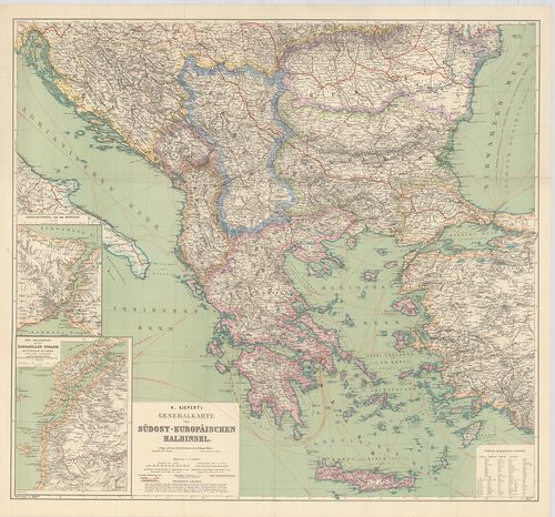
466. H. Kiepert’s Generalkarte der Südost-europäischen Halbinsel. [B III a 5/3]
Institute and Museum of Military History •
B III a
•
B III Balkán-félsziget
•
B I–XV. Európa
| Title | H. Kiepert’s Generalkarte der Südost-europäischen Halbinsel. |
| Main title | 2 mt. 1. Constantinopel und der Bosporus. (Istanbul és környéke.) 2. Der Hellespont oder die Dardanellen Strasse…(Dardanellák.) |
| Subject | A Balkán-félsziget általános térképe 1897-ben. |
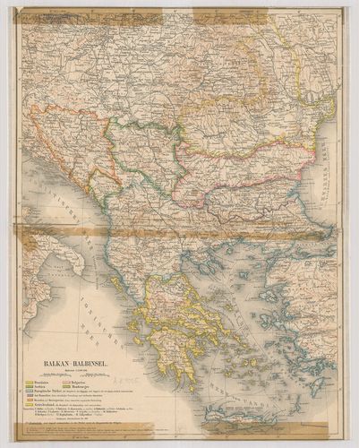
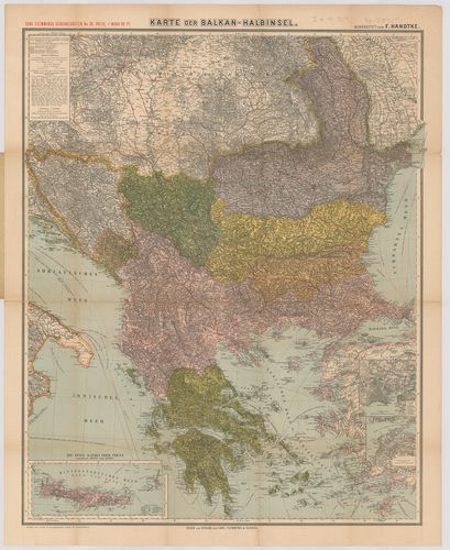
467. Übersichtskarte des Balkan-Kriegschauplatzes. [B III a 5/4]
Institute and Museum of Military History •
B III a
•
B III Balkán-félsziget
•
B I–XV. Európa
| Title | Übersichtskarte des Balkan-Kriegschauplatzes. |
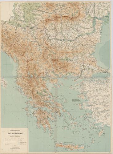
| Main title | A Balkán-hadszíntér térképe az I. világháborúban. |
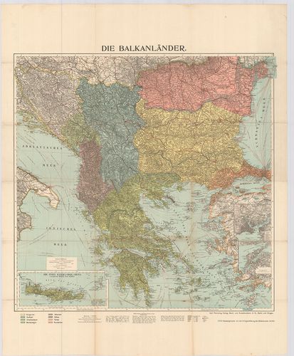
468. Südost-Europa. Die Balkanhalbinsel, Rumänien und Osterreich-... [B III a 6]
Institute and Museum of Military History •
B III a
•
B III Balkán-félsziget
•
B I–XV. Európa
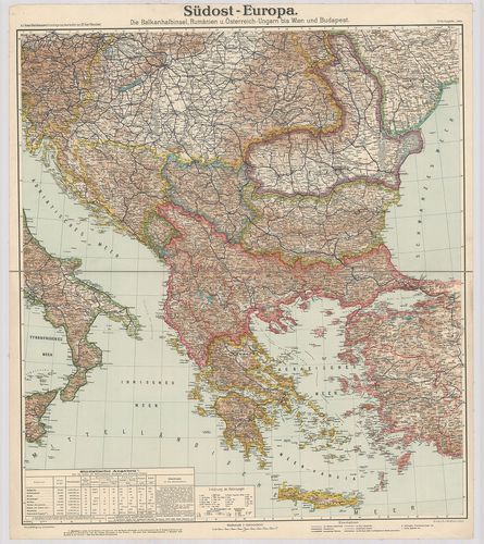
| Title | Südost-Europa. Die Balkanhalbinsel, Rumänien und Osterreich-Ungarn, bis Wien und Budapest. |
| Main title | Délkelet Európa. A Balkán-félsziget, Románia és Ausztria–Magyarország térképe 1909-ben. |
469. Karte von Südosteuropa. [B III a 6/1]
Institute and Museum of Military History •
B III a
•
B III Balkán-félsziget
•
B I–XV. Európa
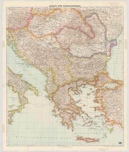
| Title | Karte von Südosteuropa. |
| Main title | Délkelet-Európa. A Balkán-félsziget térképe 1941-ben. |
470. Südost-Europa. Mit den endgültigen Grenzen nach authentische... [B III a 6/2]
Institute and Museum of Military History •
B III a
•
B III Balkán-félsziget
•
B I–XV. Európa
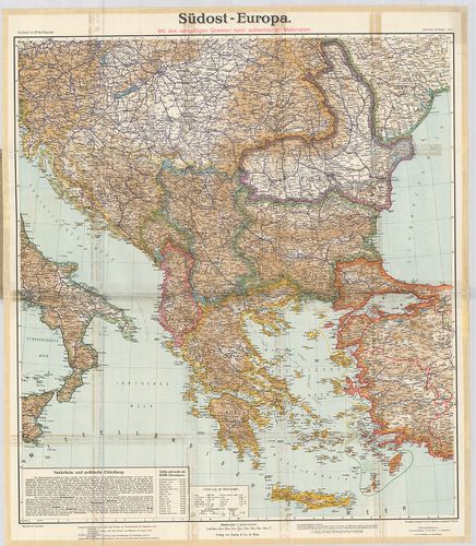
| Title | Südost-Europa. Mit den endgültigen Grenzen nach authentischen Materiale. |
| Main title | Borítékcím: Karte von Südost-Europa. Die Staaten der Balkanhalbinsel mit Teilen von Osterreich–Ungarn bis Wien und Budapest sowie Rumänien. |
| Subject | A Balkán-félsziget térképe 1914-ben. |
471. Der Europäische Orient. [B III a 7]
Institute and Museum of Military History •
B III a
•
B III Balkán-félsziget
•
B I–XV. Európa
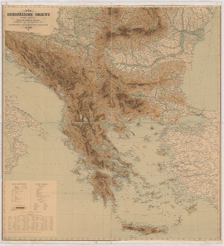
| Title | Der Europäische Orient. |
| Main title | Délkelet-Európa, a Balkán-félsziget térképe 1887-ben. |
472. Atelköz, oder das Land zwischen dem Fluss Wohnsitz der Unger... [B III a 8]
Institute and Museum of Military History •
B III a
•
B III Balkán-félsziget
•
B I–XV. Európa
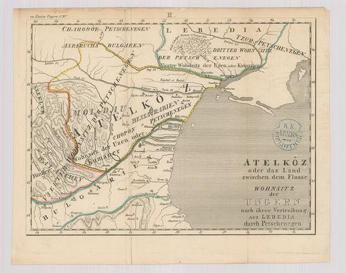
| Title | Atelköz, oder das Land zwischen dem Fluss Wohnsitz der Ungern nach ihrer Vertreibung aus Lebedia durch Petschenegen. |
| Main title | A Duna-delta vidékének térképe. |
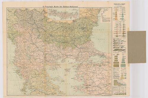
473. Karte der Balkan-Halbinsel 1909. G. Freytag’s. [B III a 8/2]
Institute and Museum of Military History •
B III a
•
B III Balkán-félsziget
•
B I–XV. Európa
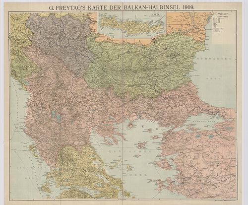
| Title | Karte der Balkan-Halbinsel 1909. G. Freytag’s. |
| Main title | Mt.: Kreta. |
| Subject | A Balkán-félsziget térképe 1909-ben. |
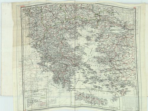
474. G. Freytag’s Karte der Balkan-Halbinsel. [B III a 8/3]
Institute and Museum of Military History •
B III a
•
B III Balkán-félsziget
•
B I–XV. Európa
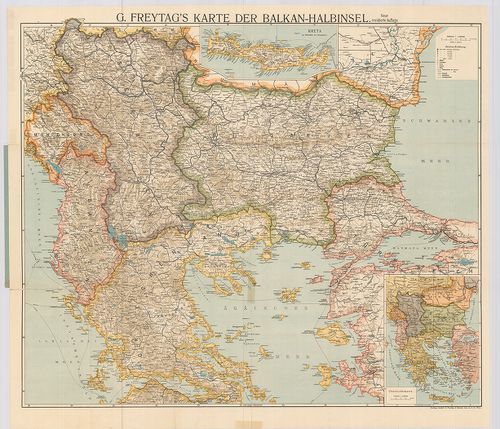
| Title | G. Freytag’s Karte der Balkan-Halbinsel. |
| Main title | Borítócím: … Mit den neuen politischen Grenzen. |
| Subject | 2 mt. 1. Kreta. |
475. Jahresbericht Balkan 1913. [B III a 8/5]
Institute and Museum of Military History •
B III a
•
B III Balkán-félsziget
•
B I–XV. Európa
| Title | Jahresbericht Balkan 1913. |
| Main title | A Balkán-félsziget vasúti térképe 1913-ban. |
476. Übersichtskarte Bulgarien-Griechenland mit eindruck der gric... [B III a 8/7]
Institute and Museum of Military History •
B III a
•
B III Balkán-félsziget
•
B I–XV. Európa
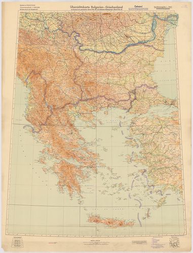
| Title | Übersichtskarte Bulgarien-Griechenland mit eindruck der grichischen (Stand Febr. 41) und türkischen Befestigungen (Stand Febr. 41.) |
| Main title | A Balkán-félsziget áttekintő térképe 1941-ben. |
477. [A Balkán-félsziget és Olaszország 1913 körül.] [B III a 8/9]
Institute and Museum of Military History •
B III a
•
B III Balkán-félsziget
•
B I–XV. Európa
| Title | [A Balkán-félsziget és Olaszország 1913 körül.] |
478. Übersichtskarte der Balkan-Halbinsel. [B III a 8/10]
Institute and Museum of Military History •
B III a
•
B III Balkán-félsziget
•
B I–XV. Európa
| Title | Übersichtskarte der Balkan-Halbinsel. |
| Main title | A Balkán-félsziget áttekintő térképe. |
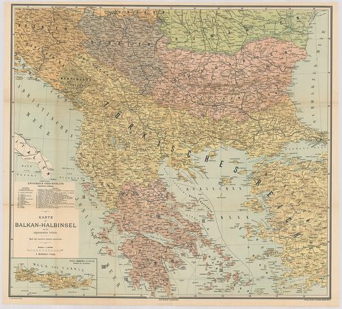
479. Karte der Balkanländer. Flemmings Kriegskarte Nr. 10. [B III a 8/11]
Institute and Museum of Military History •
B III a
•
B III Balkán-félsziget
•
B I–XV. Európa
| Title | Karte der Balkanländer. Flemmings Kriegskarte Nr. 10. |
| Main title | 2 mt.: 1. Marmara-Meer. (Márvány-tenger.) 2. [Dardanellák.]A Balkán-félsziget országainak politikai térképe 1910 körül. |
480. Die Türkisch-Griechischen Grenzgebiet. – Borítócím: F. Handt... [B III a 8/12]
Institute and Museum of Military History •
B III a
•
B III Balkán-félsziget
•
B I–XV. Európa
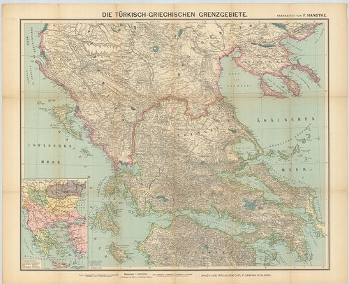
| Title | Die Türkisch-Griechischen Grenzgebiet. – Borítócím: F. Handtke’s Specialkarte der Türkisch-Griechischen Grenzgebiete mit einer Übersichtskarte der Balkanhalbinsel. |
| Main title | Mt.: Balkanhalbinsel. (A Balkán-félsziget nemzetiségi térképe.) |
| Subject | A török–görög határvidék térképe 1850 körül. |
481. G. Freytag’s Karte der Balkan-Halbinsel. [B III a 8/12/a]
Institute and Museum of Military History •
B III a
•
B III Balkán-félsziget
•
B I–XV. Európa
| Title | G. Freytag’s Karte der Balkan-Halbinsel. |
| Main title | Mt.: Kreta. Hickmann: „Statistische Daten u. Diagramme.” (Statisztikai tábl.) |
| Subject | A Balkán félsziget térképe. |
482. General Karte der Europäischen Türkei nebst Rumänien, Serbie... [B III a 8/13]
Institute and Museum of Military History •
B III a
•
B III Balkán-félsziget
•
B I–XV. Európa
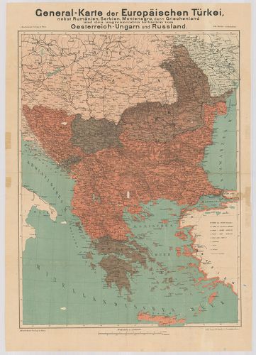
| Title | General Karte der Europäischen Türkei nebst Rumänien, Serbien, Montenegro, dann Griechenland und de angrenzenden Gebieten von Oesterreich-Ungarn und Russland. |
| Main title | Európai Törökország, Románia, Szerbia, Montenegró, Görögország, az Osztrák-Magyar Monarchia és Oroszország határos területeinek általános térképe. |
483. Generalkarte der Balkanhalbinsel. [B III a 9/1]
Institute and Museum of Military History •
B III a
•
B III Balkán-félsziget
•
B I–XV. Európa
| Title | Generalkarte der Balkanhalbinsel. |
| Main title | 5 mt. 1. Übersichtskarte der Grenzverändungen in Kleinasien. |
| Subject | (Határváltozások térképe Kisázsiában.) 2. [Dardanellák.] 3. [Istanbul.] 4. [Boszporusz.] 5. Kirid oder Kandia. [Kréta.]A Balkán-félsziget általános térképe. |
484. Die Balkanländer. [B III a 9/2]
Institute and Museum of Military History •
B III a
•
B III Balkán-félsziget
•
B I–XV. Európa
| Title | Die Balkanländer. |
| Main title | 3 mt. 1. [Istanbul.] 2. [Dardanellák.] 3. Die Insel Kandia oder Creta. [Kréta.] |
| Subject | A Balkán-félsziget térképe 1912 körül. |
485. Karte der Balkan-Halbinsel. [B III a 9/3]
Institute and Museum of Military History •
B III a
•
B III Balkán-félsziget
•
B I–XV. Európa
| Title | Karte der Balkan-Halbinsel. |
| Main title | 3 mt. 1. [Istanbul.] 2. [Dardanellák.] 3. Die Insel Kandia oder Creta. [Kréta.] |
| Subject | A Balkán-félsziget térképe. |
486. Karte der Balkan-Halbinsel und der angrenzenden Gebiete. [B III a 9/4]
Institute and Museum of Military History •
B III a
•
B III Balkán-félsziget
•
B I–XV. Európa
| Title | Karte der Balkan-Halbinsel und der angrenzenden Gebiete. |
| Main title | Mt.: Insel Kreta. (Candia.) |
| Subject | A Balkán-félsziget általános térképe 1897-ben. |
487. Politisch-militärische Karte der Balkan-Halbinsel. [B III a 10]
Institute and Museum of Military History •
B III a
•
B III Balkán-félsziget
•
B I–XV. Európa
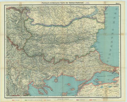
| Title | Politisch-militärische Karte der Balkan-Halbinsel. |
| Main title | 4 mt. 1. Kostantinopel. (Istanbul.) 2. Athen. 3. Dia Dardanellen. (Dardanellák.) 4. Die Bosporus. (Boszporusz.)A Balkán-félsziget politikai-katonai térképe 1913 végén. |
488. Karte der Balkan-Halbinsel und der angrenzenden Gebiete. [B III a 10/1]
Institute and Museum of Military History •
B III a
•
B III Balkán-félsziget
•
B I–XV. Európa
| Title | Karte der Balkan-Halbinsel und der angrenzenden Gebiete. |
| Main title | Mt.: Insel Kreta. (Candia.) |
| Subject | A Balkán-félsziget térképe. |
489. A Balkán háború térképe. [B III a 10/3]
Institute and Museum of Military History •
B III a
•
B III Balkán-félsziget
•
B I–XV. Európa
| Title | A Balkán háború térképe. |
490. Karte des österreichisch-serbischen Kriegsschauplatzes. [B III a 10/4]
Institute and Museum of Military History •
B III a
•
B III Balkán-félsziget
•
B I–XV. Európa
| Title | Karte des österreichisch-serbischen Kriegsschauplatzes. |
| Main title | Az osztrák–magyar–szerb hadszíntér térképe. |
491. Generalkarte der Balkanhalbinsel. [B III a 11]
Institute and Museum of Military History •
B III a
•
B III Balkán-félsziget
•
B I–XV. Európa
| Title | Generalkarte der Balkanhalbinsel. |
| Main title | 5 mt. 1. Umgegend von Sarajewo. (Szarajevó és környéke.) 2. [Boszporusz.] 3. Kirid oder Kandia. (Kréta.) 4. Konstantinápoly. (Istanbul.) 5. Dardanellák.A Balkán-félsziget általános térképe 1880 körül. |
492. Die Donau-Länder und die Balkan-Halbinsel. Carta perspective... [B III a 13]
Institute and Museum of Military History •
B III a
•
B III Balkán-félsziget
•
B I–XV. Európa
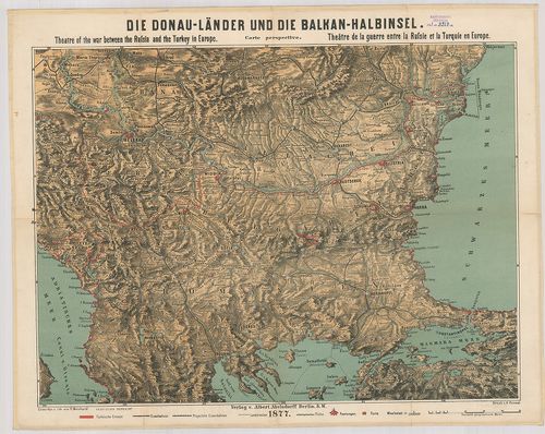
| Title | Die Donau-Länder und die Balkan-Halbinsel. Carta perspective. – Theatre of the war bethwen the Russia and the Turkey in Europe. – Theatre de la guerre entre la Russie et la Turquie en Europe. |
| Main title | A Balkán-félsziget középső részének perspektívikus térképe 1877-ben. |
493. Politisch-militärische Karte der Balkan-Halbinsel. [B III a 14]
Institute and Museum of Military History •
B III a
•
B III Balkán-félsziget
•
B I–XV. Európa
| Title | Politisch-militärische Karte der Balkan-Halbinsel. |
| Main title | A Balkán-félsziget politikai és katonai térképe. |
494. [Montenegró, Szerbia Albánia és a határos területek áttekint... [B III a 15]
Institute and Museum of Military History •
B III a
•
B III Balkán-félsziget
•
B I–XV. Európa
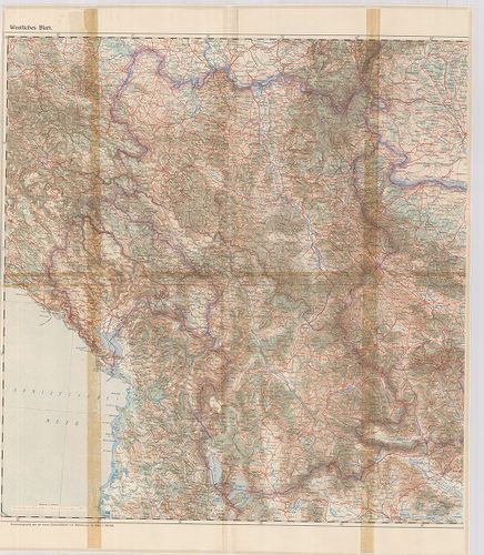
| Title | [Montenegró, Szerbia Albánia és a határos területek áttekintő térképe.] Westliches Blatt. (Ny-lap) |
495. Karte des grössten Theils des europaeisch-osmanischen Reichs... [B III a 17]
Institute and Museum of Military History •
B III a
•
B III Balkán-félsziget
•
B I–XV. Európa
| Title | Karte des grössten Theils des europaeisch-osmanischen Reichs, enthaltend die Moldau, Bessarabien, Wallachey, Bulgarien und Rumelien. – Carte de la plus grande partie de la Turquie d’Europe contenant la Moldavie, la Bessarabie, la Valachie, la Bulgarie et la Roumelie. |
| Main title | Az Európai Török Birodalom térképe. |
496. Generalnaja karta Valahii, Bulgarii i Rumilii. [B III a 17/1]
Institute and Museum of Military History •
B III a
•
B III Balkán-félsziget
•
B I–XV. Európa
| Title | Generalnaja karta Valahii, Bulgarii i Rumilii. |
| Main title | Havasalföld, Bulgária és Rumélia általános térképe 1828-ban. |
497. General Karte von Bosnien, der Hercegovina von Serbien und M... [B III a 18/2]
Institute and Museum of Military History •
B III a
•
B III Balkán-félsziget
•
B I–XV. Európa
| Title | General Karte von Bosnien, der Hercegovina von Serbien und Montenegro. |
| Main title | Bosznia, Hercegovina, Szerbia és Montenegró általános térképe 1876-ban. |
498. Hand-Karte von Bosnien, der Herzegovina, Novibazar, Monteneg... [B III a 18/3]
Institute and Museum of Military History •
B III a
•
B III Balkán-félsziget
•
B I–XV. Európa
| Title | Hand-Karte von Bosnien, der Herzegovina, Novibazar, Montenegro und dem Österr.–Ungar. Küsten Gebiete. |
| Main title | Bosznia, Hercegovina, Novi Pazar, Montenegró és az Osztrák–Magyar Tengerpart térképe 1878-ban. |
499. Uibersichts-Karte von Bosnien, Hercegovina, Montenegro und W... [B III a 19]
Institute and Museum of Military History •
B III a
•
B III Balkán-félsziget
•
B I–XV. Európa
| Title | Uibersichts-Karte von Bosnien, Hercegovina, Montenegro und West-Serbien. |
| Main title | Bosznia, Hercegovina, Montenegró és Szerbia Ny-i részének térképe. |
500. Generalkarte von Bulgarien, Rumelien und Macedonien. [B III a 20/1]
Institute and Museum of Military History •
B III a
•
B III Balkán-félsziget
•
B I–XV. Európa
| Title | Generalkarte von Bulgarien, Rumelien und Macedonien. |
| Main title | Bulgária, Rumélia és Macedonia általános térképe 1885-ben. |