2241. Carta Corografica della Divisione Ecclesiastica, Politica e ... [B IX a 58]
Institute and Museum of Military History •
B IX a
•
B IX Ausztria–Magyarország
•
B I–XV. Európa
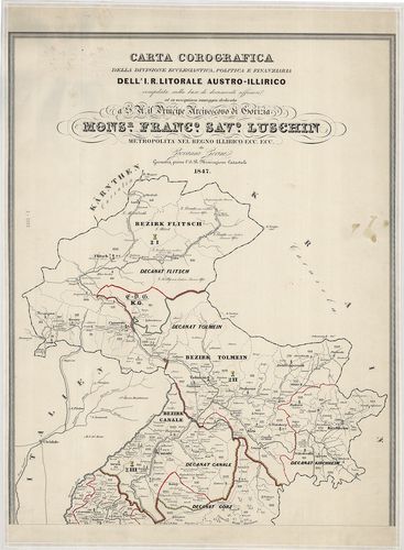
| Title | Carta Corografica della Divisione Ecclesiastica, Politica e Finanziaria Dell’ I. R. Litorale Austro-Illirico… |
| Main title | Az Isztriai félsziget (D-Illíria) térképe egyházmegyei-közig. pénzügyőri beosztással 1847-ben. |
2242. Regni Bohemiae Circulus Kaurzimensis ex Müllerianis aliisque... [B IX a 61]
Institute and Museum of Military History •
B IX a
•
B IX Ausztria–Magyarország
•
B I–XV. Európa
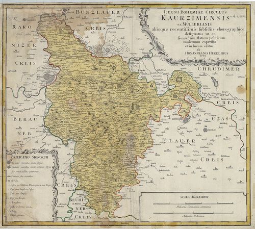
| Title | Regni Bohemiae Circulus Kaurzimensis ex Müllerianis aliisque ecentissimis subsidiis chorographice designatus… |
| Main title | Csehország, Kaurzimen kerület (Prágától K-re) térképe 1773-ban. |
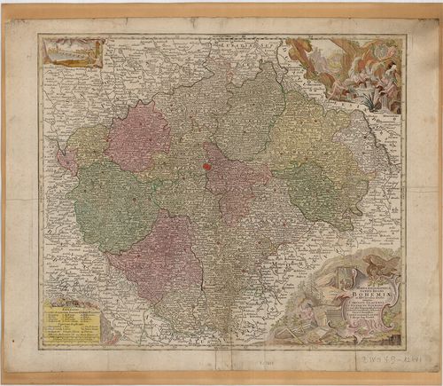
2243. Bohemiae Regnum in XII. Circulus divisum Com. Glac. et Distr... [B IX a 62]
Institute and Museum of Military History •
B IX a
•
B IX Ausztria–Magyarország
•
B I–XV. Európa
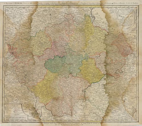
| Title | Bohemiae Regnum in XII. Circulus divisum Com. Glac. et Distr. Egerano ceterisqu circumjacentibus terris ex Müllerianis aliisqu chorographicis… |
| Main title | Csehország térképe a 18. században, a 12 ker. és Gacen megye jelölésével. |
2244. Karte von dem Königreiche Böheim. [B IX a 63]
Institute and Museum of Military History •
B IX a
•
B IX Ausztria–Magyarország
•
B I–XV. Európa
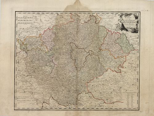
| Title | Karte von dem Königreiche Böheim. |
| Main title | Csehország térképe 1796-ban. |
2245. Archiducatus Austriae Inferioris In onmes suas Quadrantes Di... [B IX a 66]
Institute and Museum of Military History •
B IX a
•
B IX Ausztria–Magyarország
•
B I–XV. Európa
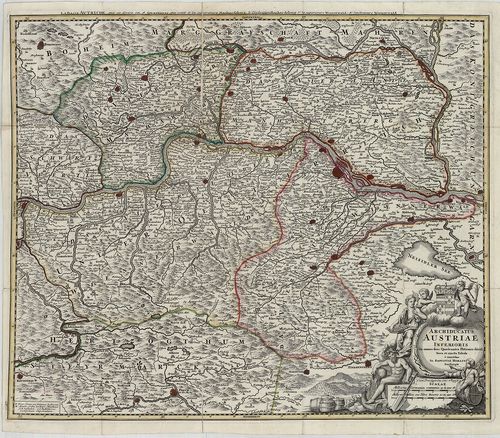
| Title | Archiducatus Austriae Inferioris In onmes suas Quadrantes Ditiones divisi Nova et Tabula… |
| Main title | Alsó-Ausztria térképe a 18. században. |
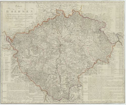
2246. Des Königreiche Boehmen in deutsch und böhmischen Sprache, n... [B IX a 67]
Institute and Museum of Military History •
B IX a
•
B IX Ausztria–Magyarország
•
B I–XV. Európa
| Title | Des Königreiche Boehmen in deutsch und böhmischen Sprache, nach der neuesten Einthelung in 16 Kreise mit dem Egerischen Bezirke, dem Asch und Freisischen Gebiete, dann der Grafschaft Glatz… |
| Main title | A Cseh Királyság térképe a 16 körzet jelölésével 1799-ben. |
2247. Charte von Boehmen. [B IX a 69]
Institute and Museum of Military History •
B IX a
•
B IX Ausztria–Magyarország
•
B I–XV. Európa
| Title | Charte von Boehmen. |
| Main title | Csehország 1806-ban. |
2248. Charte von Boehmen. Nach den neuesten Bestimmungen und zuver... [B IX a 69/1]
Institute and Museum of Military History •
B IX a
•
B IX Ausztria–Magyarország
•
B I–XV. Európa
| Title | Charte von Boehmen. Nach den neuesten Bestimmungen und zuverlässigen Hilfsmitteln. |
| Main title | Csehország térképe 1806-ban. |
2249. Charte vom Königreiche Böheim… [B IX a 70]
Institute and Museum of Military History •
B IX a
•
B IX Ausztria–Magyarország
•
B I–XV. Európa
| Title | Charte vom Königreiche Böheim… |
| Main title | A Cseh Királyság térképe 1820-ban. |
2250. Charte des Nördlichen Theils von dem Königreiche Böhmen… [B IX a 71]
Institute and Museum of Military History •
B IX a
•
B IX Ausztria–Magyarország
•
B I–XV. Európa
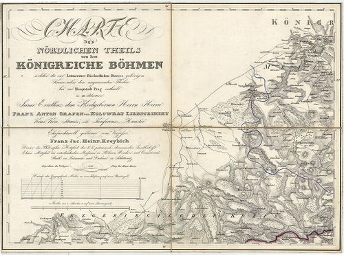
| Title | Charte des Nördlichen Theils von dem Königreiche Böhmen… |
| Main title | A Cseh Királyság É-i részének részletes térképe 1833-ban. |
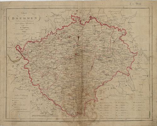
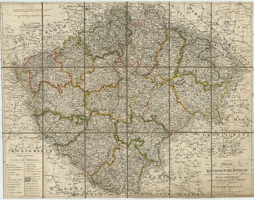
2251. Charte vom Königreiche Böheim nach den Ortsbestimmungen des ... [B IX a 72]
Institute and Museum of Military History •
B IX a
•
B IX Ausztria–Magyarország
•
B I–XV. Európa
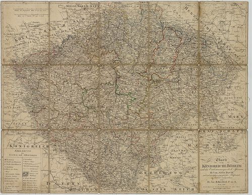
| Title | Charte vom Königreiche Böheim nach den Ortsbestimmungen des K. Astronom H. Can. Alois David und nach zuverlässigen Geographischen Hülfsmitteln. |
| Main title | A Cseh Királyság térképe 1827-ben ker. beosztással. |
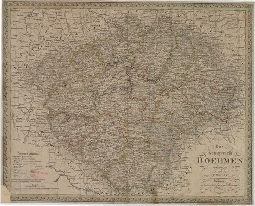
2252. Das Königreich Böhmen. [B IX a 73]
Institute and Museum of Military History •
B IX a
•
B IX Ausztria–Magyarország
•
B I–XV. Európa
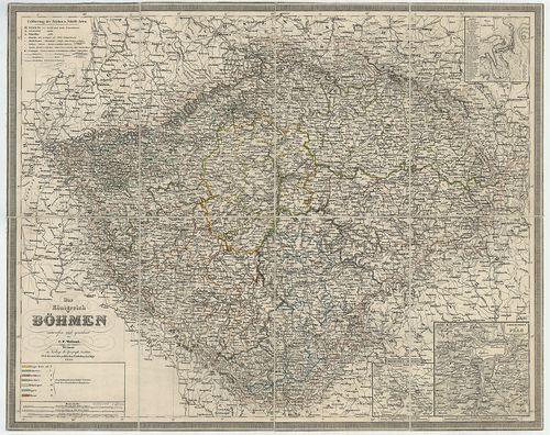
| Title | Das Königreich Böhmen. |
| Main title | 3 mt. 1. Plan von Carlsbad. (Karsbad, Karlovy Vary, várostervezet.) 2. Umgebung von Teplitz. (Teplice és körny.) 3. Umgebung von Prag. (Prága és körny.) |
| Subject | A Cseh Királyság térképe 1850-ben. |
2253. Das Königreich Boehmen. [B IX a 73/2]
Institute and Museum of Military History •
B IX a
•
B IX Ausztria–Magyarország
•
B I–XV. Európa
| Title | Das Königreich Boehmen. |
| Main title | A Cseh Királyság térképe 1829-ben. |
2254. Das Königreich Böhmen. [B IX a 73]
Institute and Museum of Military History •
B IX a
•
B IX Ausztria–Magyarország
•
B I–XV. Európa
| Title | Das Königreich Böhmen. |
| Main title | 3 mt. 1. Plan von Carlsbad. (Karlsbad, Karlovy Vary várostervezet.) 2. Umgebung v. Teplitz. (Teplice és környéke.) 3. Umgebung von Prag. (Prága és körny.) |
| Subject | A Cseh Királyság térképe 1852-ben. |
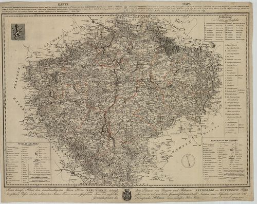
2255. Králowstwi České: Uprawil a Pomocí Českého Museum. [B IX a 74]
Institute and Museum of Military History •
B IX a
•
B IX Ausztria–Magyarország
•
B I–XV. Európa
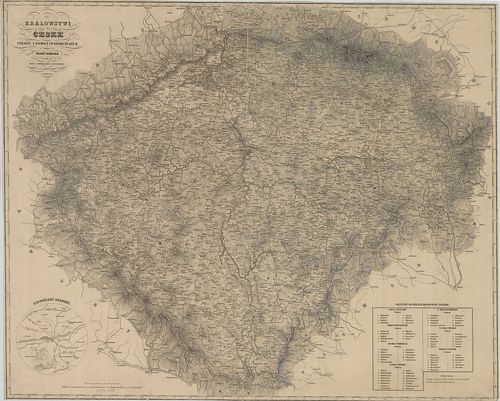
| Title | Králowstwi České: Uprawil a Pomocí Českého Museum. |
| Main title | Csehország térképe 1850-ben. |
2256. Handkarte des Königreiches Böhmen. [B IX a 75]
Institute and Museum of Military History •
B IX a
•
B IX Ausztria–Magyarország
•
B I–XV. Európa
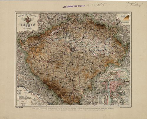
| Title | Handkarte des Königreiches Böhmen. |
| Main title | Mt. Prag. (Prága várostérkép.) |
| Subject | A Cseh Királyság térképe 1880 körül. |
2257. Königreich Böhmen. Markgrafschaft Mähren. Herzogthum Schlesi... [B IX a 76]
Institute and Museum of Military History •
B IX a
•
B IX Ausztria–Magyarország
•
B I–XV. Európa
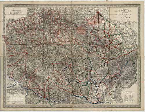
| Title | Königreich Böhmen. Markgrafschaft Mähren. Herzogthum Schlesien. |
| Main title | „Scheda und Steinhauser Atlas. Böhmen, Mähren u. Schlesien.” lapja. |
| Subject | Cseh–, Morvaország és Szilézia térképe 1877-ben. |
2258. Mappa Geographica Regnum Bohemiae cum adiunctis Ducatu[s] Si... [B IX a 77]
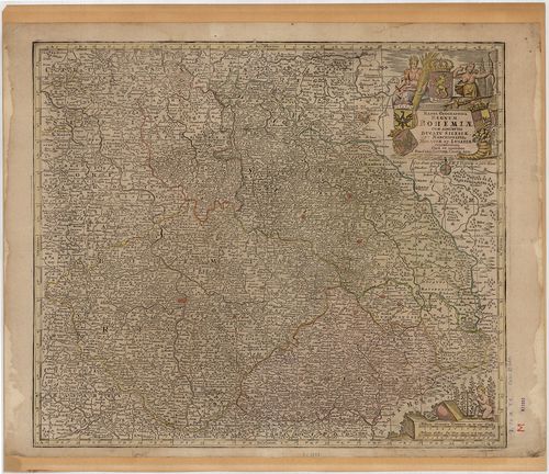
Institute and Museum of Military History •
B IX a
•
B IX Ausztria–Magyarország
•
B I–XV. Európa
| Title | Mappa Geographica Regnum Bohemiae cum adiunctis Ducatu[s] Silesiae, et Marchionatib. Moraviae, et Lusatiae… |
| Main title | Csehország, Szilézia, Morvaország és Lausitz őrgrófság térképe a 18. században. |
2259. Nova et accurata Descriptio Geographica Totius Regni Bohemia... [B IX a 78]
Institute and Museum of Military History •
B IX a
•
B IX Ausztria–Magyarország
•
B I–XV. Európa
| Title | Nova et accurata Descriptio Geographica Totius Regni Bohemiae, Eidemque incorporati Comitatus Glacensis… |
| Main title | Csehország térképe a 18. században. |
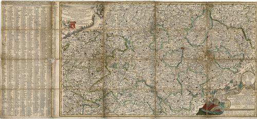
2260. Mappa Geographica totius Regni Bohemiae in XII. Circulus div... [B IX a 79]
Institute and Museum of Military History •
B IX a
•
B IX Ausztria–Magyarország
•
B I–XV. Európa
| Title | Mappa Geographica totius Regni Bohemiae in XII. Circulus divisae, annexis Comitatu Glacensi et Districtu Egerano… |
| Main title | Csehország térképe 1758-ban a XII. ker. megnevezésével és jelölésével. |