2441. General Post- und Strassenkarte des Kronlandes Galizien und ... [B IX a 390]
Institute and Museum of Military History •
B IX a
•
B IX Ausztria–Magyarország
•
B I–XV. Európa
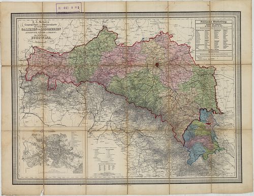
| Title | General Post- und Strassenkarte des Kronlandes Galizien und Lodomerien Ausschwitz, (Ošviecim) Zator, und Krakau, (Kraków) so wie des Kronlandes Bukowina. |
| Main title | Mt. Plan von Lemberg. (Lvov várostérk.) |
| Subject | Galícia, Volhínia és Bukovina általános térképe 1874-ben, posta és úthálózattal. |
2442. Übersichtskarte der erzherzoglichen Herrschaft Saybusch in G... [B IX a 391]
Institute and Museum of Military History •
B IX a
•
B IX Ausztria–Magyarország
•
B I–XV. Európa
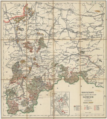
| Title | Übersichtskarte der erzherzoglichen Herrschaft Saybusch in Galizien. |
| Main title | Mt. Saybusch. (Zywiec várostérkép.) |
| Subject | Galícia: Saybusch hercegség áttekintő térképe a 19. században. |
2443. Uibersichts-Karte für die Vertheidigung Tirol’s im Jahre 186... [B IX a 392]
Institute and Museum of Military History •
B IX a
•
B IX Ausztria–Magyarország
•
B I–XV. Európa
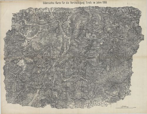
| Title | Uibersichts-Karte für die Vertheidigung Tirol’s im Jahre 1866. |
| Main title | Dél-Tirol áttekintő térképe 1866-ban. (Mühlbachtól D-re.) |
2444. Mapa Komunikacyjna Galicyi i Bukowiny. [B IX a 400]
Institute and Museum of Military History •
B IX a
•
B IX Ausztria–Magyarország
•
B I–XV. Európa
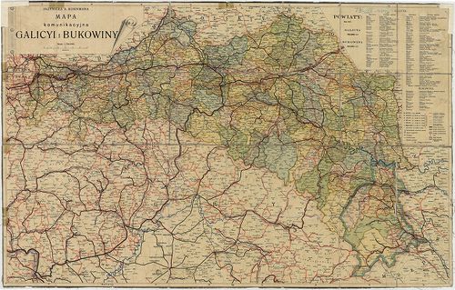
| Title | Mapa Komunikacyjna Galicyi i Bukowiny. |
| Main title | Galícia és Bukovina közlekedési térképe 1911 körül. |
2445. Krakó Köz-Társaság. [B IX a 401]
Institute and Museum of Military History •
B IX a
•
B IX Ausztria–Magyarország
•
B I–XV. Európa
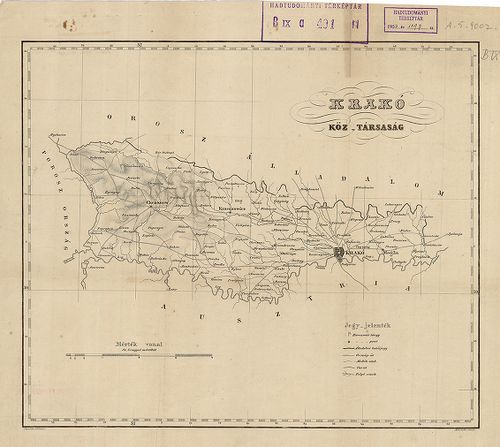
| Title | Krakó Köz-Társaság. |
2446. Karte Okregu Wolnego Miasta Krakowa. – Carte du territoire d... [B IX a 402]
Institute and Museum of Military History •
B IX a
•
B IX Ausztria–Magyarország
•
B I–XV. Európa
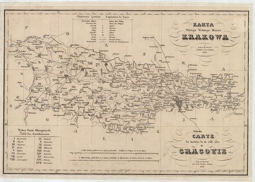
| Title | Karte Okregu Wolnego Miasta Krakowa. – Carte du territoire de la ville libre de Cracivie. |
| Main title | Krakkó szabad terület térképe 1833-ban. |
2447. Karte des Krakauer Kreisesim Königreiche Galizien. – Mapa Ob... [B IX a 403]
Institute and Museum of Military History •
B IX a
•
B IX Ausztria–Magyarország
•
B I–XV. Európa
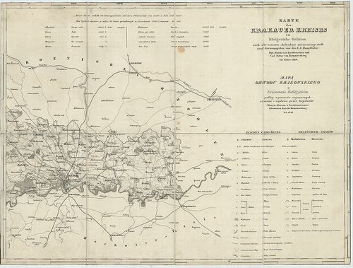
| Title | Karte des Krakauer Kreisesim Königreiche Galizien. – Mapa Obwodu Krakowskiego w Królestwie Galicyjskim… |
| Main title | A Krakkói kerület térképe 1849-ben. |
2448. Karte des Krakauer Verwaltungsgebietes. [B IX a 404]
Institute and Museum of Military History •
B IX a
•
B IX Ausztria–Magyarország
•
B I–XV. Európa
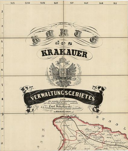
| Title | Karte des Krakauer Verwaltungsgebietes. |
| Main title | A Krakkói kerület közigazgatási térképe 1856-ban. |
2449. Königreich Galicien. Kreis Przemyśl. [B IX a 405]
Institute and Museum of Military History •
B IX a
•
B IX Ausztria–Magyarország
•
B I–XV. Európa
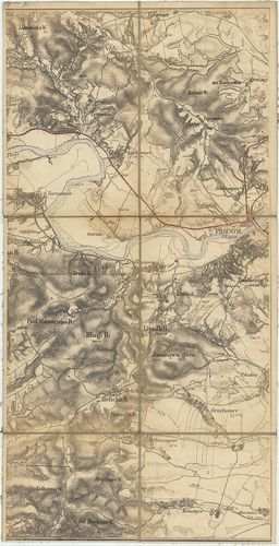
| Title | Königreich Galicien. Kreis Przemyśl. |
| Main title | A Galíciai Királyság Przemyśli kerületének néhány szelvénye a II. katonai felmérésből: W. VI. 8., VII. 8., VIII. 7, 8. szelvények. |
2450. Übersichtskarte des nördlichen Kriegsschauplatzes. [B IX a 406]
Institute and Museum of Military History •
B IX a
•
B IX Ausztria–Magyarország
•
B I–XV. Európa
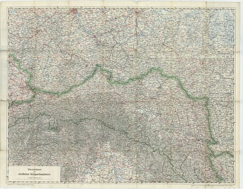
| Title | Übersichtskarte des nördlichen Kriegsschauplatzes. |
| Main title | Az orosz hadszíntér áttekintő térképe 1914-ben. (Łódž, – Warscho, Varsó, Warszava – Rowno, Rovno – Schemnitz, Selmecbánya, Banska Stiavnica – Botoşani kivágat.) |
2451. Karte des Wadowicer Kreises im Königreiche Galizien… – Mapa ... [B IX a 409]
Institute and Museum of Military History •
B IX a
•
B IX Ausztria–Magyarország
•
B I–XV. Európa
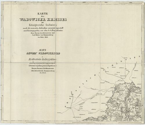
| Title | Karte des Wadowicer Kreises im Königreiche Galizien… – Mapa Obwodu Wadowiekiego w Królestwie Galicyjskim. |
| Main title | A Wadowicei kerület topográfiai térképe 1849-ben. |
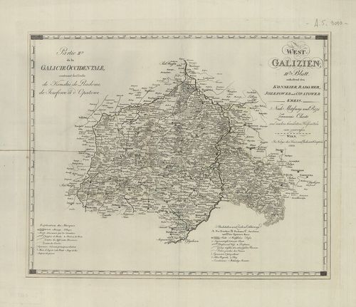
2452. West Galizien. I.-tes Blatt enthaltend den Krakauer, Slomnik... [B IX a 414]
Institute and Museum of Military History •
B IX a
•
B IX Ausztria–Magyarország
•
B I–XV. Európa
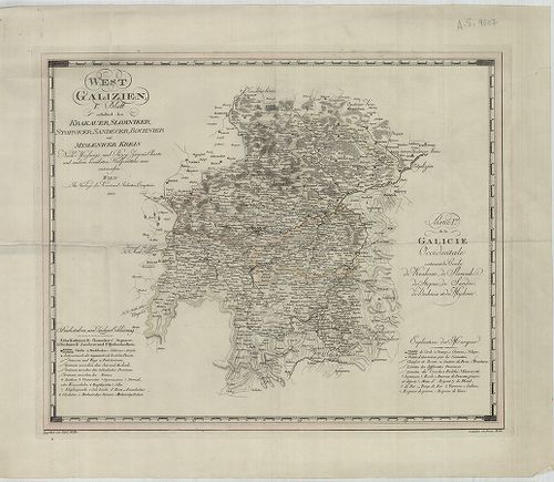
| Title | West Galizien. I.-tes Blatt enthaltend den Krakauer, Slomniker, Stopnicer, Sandecer, Bochnier und Myslenicer Kreis. – Partie I.-re de la Galicie Occidentale contenant les Cercles de Krakovie, de Slomnik de Stopnic, de Sandec, de Bochnia et de Myslenic. |
| Main title | Nyugat-Galícia térképe 1803-ban, 6 kerület megjelölésével. |
2453. Ost-Galizien, Erstes Blatt enthaltend den Tarnower, Rzeszowe... [B IX a 415]
Institute and Museum of Military History •
B IX a
•
B IX Ausztria–Magyarország
•
B I–XV. Európa
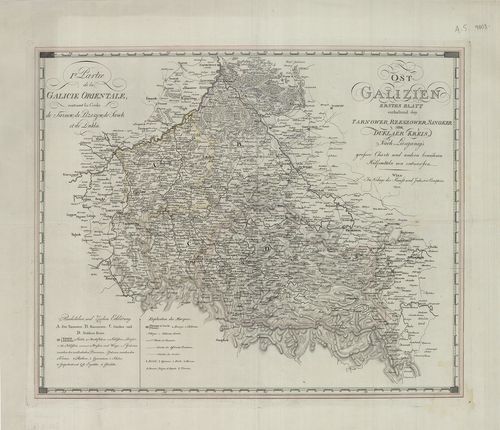
| Title | Ost-Galizien, Erstes Blatt enthaltend den Tarnower, Rzeszower, Sanoker, und Duklaer Kreis. – I. re Partie de la Galicie Orientale: Contenant les Cercles de Tarnow, de Rzeszow, de Sanok et de Dukla. |
| Main title | Kelet-Galícia térképe 1803-ban, 4 ker. megjelölésével. |
2454. Ost Galizien. Zweites Blatt enthaltend den Zamoscer, Zolkiew... [B IX a 416]
Institute and Museum of Military History •
B IX a
•
B IX Ausztria–Magyarország
•
B I–XV. Európa
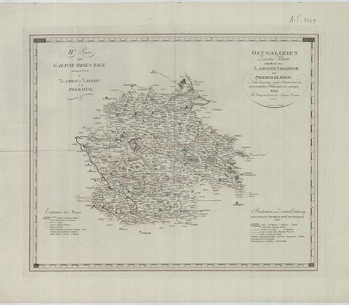
| Title | Ost Galizien. Zweites Blatt enthaltend den Zamoscer, Zolkiewer und Przemysler Kreis. – II. de Partie de la Galicie Orientale contenant les Cercles de Zamosc, de Zolkiev, et de Przemysl. |
| Main title | Kelet-Galícia térképe 1803-ban, 3 ker. megjelölésével. |
2455. West Galizien. II-tes Blatt enthaltend den Konskier, Radomer... [B IX a 417]
Institute and Museum of Military History •
B IX a
•
B IX Ausztria–Magyarország
•
B I–XV. Európa
| Title | West Galizien. II-tes Blatt enthaltend den Konskier, Radomer, Jozefower und Opatower Kreis. – Partie II.-me de la Galicie Occidentale, contenant les Cercles de Konskie, de Radome, de Jozefowe et d’Opatowe. |
| Main title | Nyugat-Galícia térképe 1803-ban, 4 kerület megjelölésével. |
2456. West Galizien. III.-tes Blatt enthaltend den Wiazowner, Sied... [B IX a 418]
Institute and Museum of Military History •
B IX a
•
B IX Ausztria–Magyarország
•
B I–XV. Európa
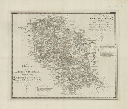
| Title | West Galizien. III.-tes Blatt enthaltend den Wiazowner, Siedlcer, Bialer, Chelmer und Lubliner Kreis. – Partie III.-me de la Galicie Occidentale, contenant les Cercles de Wiazowna, de Siedlze, de Biala, de Chelm, et de Lublin. |
| Main title | Nyugat-Galícia térképe 1803-ban, 5 kerület megjelölésével. |
2457. Ost-Galizien. IV.-es Blatt enthaltend den Sanislawoner, Zale... [B IX a 419]
Institute and Museum of Military History •
B IX a
•
B IX Ausztria–Magyarország
•
B I–XV. Európa
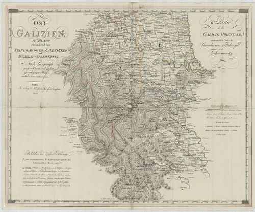
| Title | Ost-Galizien. IV.-es Blatt enthaltend den Sanislawoner, Zaleszyker und Tschernowitzer Kreis. – IV.-eme Partie de la Galicie Orientale, contenant les Cercles de Stanislawow, de Zaleszyk, et de Tschernowitz. |
| Main title | Kelet-Galícia térképe 1803-ban, 3 kerület megjelölésével. |
2458. Galícia és Bukovina. [B IX a 420]
Institute and Museum of Military History •
B IX a
•
B IX Ausztria–Magyarország
•
B I–XV. Európa
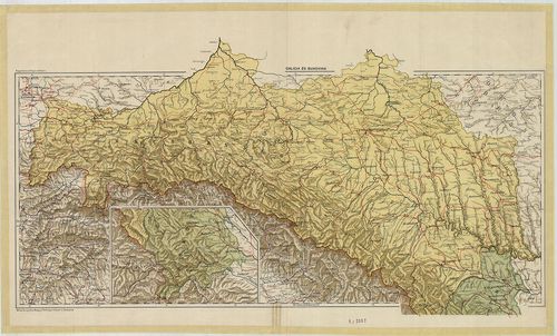
| Title | Galícia és Bukovina. |
2459. Galícia és Bukovina. [B IX a 421]
Institute and Museum of Military History •
B IX a
•
B IX Ausztria–Magyarország
•
B I–XV. Európa
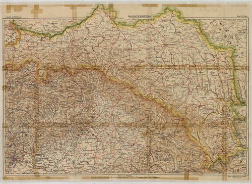
| Title | Galícia és Bukovina. |
2460. Galizien und Nordost–Ungarn. [B IX a 422]
Institute and Museum of Military History •
B IX a
•
B IX Ausztria–Magyarország
•
B I–XV. Európa
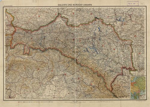
| Title | Galizien und Nordost–Ungarn. |
| Main title | Mt. Übersichtskarte von Osteuropa. (K-Európa áttekintő térk.) |
| Subject | Galícia és Magyarország ÉK-i részének térképe 1910 körül. |