2581. Royaume de Hongrie, Principauté de Transilvanie, Sclavonie, ... [B IX a 539/16]
Institute and Museum of Military History •
B IX a
•
B IX Ausztria–Magyarország
•
B I–XV. Európa
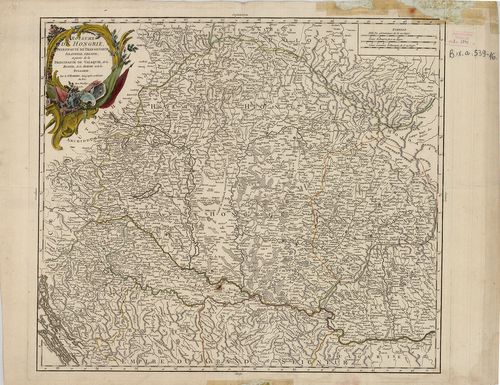
| Title | Royaume de Hongrie, Principauté de Transilvanie, Sclavonie, Croatie, et partie de la Principauté de Valaquie, de la Bosnie, de la Servie et de la Bulgarie. |
| Main title | A Magyar Királyság, Erdély, Horvát-Szlavónia és a Balkán É-i részének térképe 1751-ben. |
2582. Regni Hungariae, Graeciae et Moreae, Regionumque Finitimarum... [B IX a 539/17]
Institute and Museum of Military History •
B IX a
•
B IX Ausztria–Magyarország
•
B I–XV. Európa
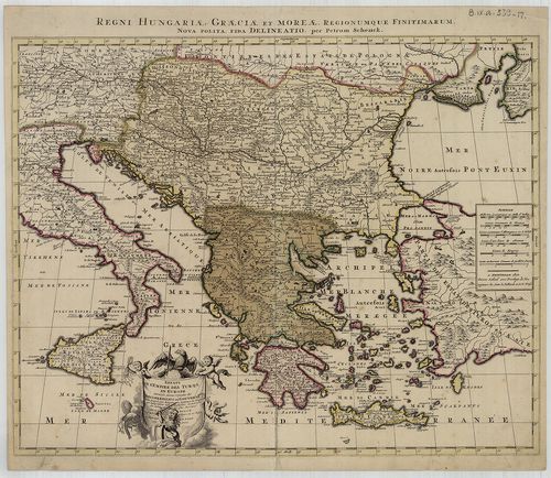
| Title | Regni Hungariae, Graeciae et Moreae, Regionumque Finitimarum. |
| Main title | A Magyar Királyság és a Balkán-félsziget államainak térképe a 18. sz. elején. |
2583. Hungaria cum adiacentibus Provinciis nova et accuratiori for... [B IX a 539/18]
Institute and Museum of Military History •
B IX a
•
B IX Ausztria–Magyarország
•
B I–XV. Európa

| Title | Hungaria cum adiacentibus Provinciis nova et accuratiori forma exhibetur… |
| Main title | Magyarország és a szomszédos államok térképe 1716 körül. |
2584. Tabula Hungaria et Regionum, quae praeterea ab ea dependent,... [B IX a 539/19]
Institute and Museum of Military History •
B IX a
•
B IX Ausztria–Magyarország
•
B I–XV. Európa
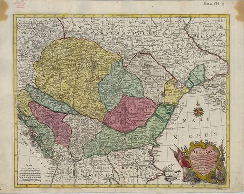
| Title | Tabula Hungaria et Regionum, quae praeterea ab ea dependent, Delineata juxta magnum numerum annotationum et mappas manuscriptas vel impressas… |
| Main title | Magyarország és a környező államok térképe a 18. században. |
2585. Länder der Ungarischen Krone. [B IX a 543]
Institute and Museum of Military History •
B IX a
•
B IX Ausztria–Magyarország
•
B I–XV. Európa
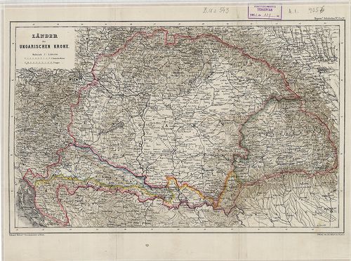
| Title | Länder der Ungarischen Krone. |
| Main title | A Magyar Korona országai: Magyarország, Erdély, Horvát-Szlavónia térképe 1860 körül. |
2586. [A Duna–Tisza köze és Felső-Magyarország térképe 1790-ben.] [B IX a 547]
Institute and Museum of Military History •
B IX a
•
B IX Ausztria–Magyarország
•
B I–XV. Európa
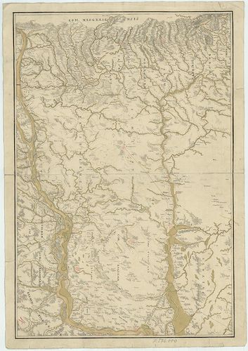
| Title | [A Duna–Tisza köze és Felső-Magyarország térképe 1790-ben.] |
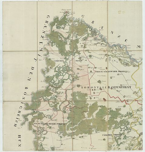
2587. Tabula Banatus Temesiensis a geometris… [B IX a 567]
Institute and Museum of Military History •
B IX a
•
B IX Ausztria–Magyarország
•
B I–XV. Európa
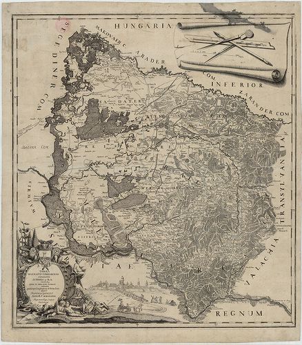
| Title | Tabula Banatus Temesiensis a geometris… |
| Main title | A Temesi Bánság térképe 1776-ban. |
2588. Tabula Banatus Temesiensis 1776. [B IX a 567/1]
Institute and Museum of Military History •
B IX a
•
B IX Ausztria–Magyarország
•
B I–XV. Európa
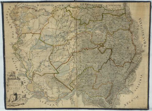
| Title | Tabula Banatus Temesiensis 1776. |
| Main title | A Temesi Bánság térképe 1776-ban. |
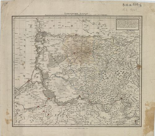
2589. Geographische Charte von Temeswarer Banat welche die Flüsse,... [B IX a 572]
Institute and Museum of Military History •
B IX a
•
B IX Ausztria–Magyarország
•
B I–XV. Európa
| Title | Geographische Charte von Temeswarer Banat welche die Flüsse, Ortschaften und Weege nach dem Bestand im Jahre 1805. |
| Main title | A Temesi Bánság földrajzi térképe 1805-ben, úthálózattal, megyebeosztással. |
2590. General-Karte de Vojvodschaft Serbien und des Temescher Bana... [B IX a 574]
Institute and Museum of Military History •
B IX a
•
B IX Ausztria–Magyarország
•
B I–XV. Európa
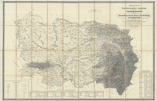
| Title | General-Karte de Vojvodschaft Serbien und des Temescher Banates dann der vier Gränzregimenter Peterwardeiner, Deutsch-Banater, Illirisch-Banater ind Roman-Banater… |
| Main title | A Temesi-Bánság, a Szerb Vajdaság és a Katonai Határőrvidék, (Péterváradi, Német-Bánsági, Illir-Bánsági és a Oláh-Bánsági ezred) általános térképe 1853-ban, a II. katonai felmérés alapján. |
2591. Karte der Wojwodschaft Serbien und des Temescher Banates neb... [B IX a 574/1]
Institute and Museum of Military History •
B IX a
•
B IX Ausztria–Magyarország
•
B I–XV. Európa
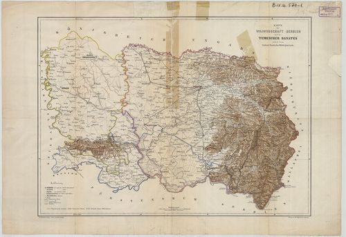
| Title | Karte der Wojwodschaft Serbien und des Temescher Banates nebst dem Serbisch-Banatischen Militärgränzlande. |
| Main title | A Szerb Vajdaság és a Temesi Bánság térképe 1850 körül. |
2592. Nova Mappa Geographica Princip: Transilvaniae, Districtus Te... [B IX a 576]
Institute and Museum of Military History •
B IX a
•
B IX Ausztria–Magyarország
•
B I–XV. Európa
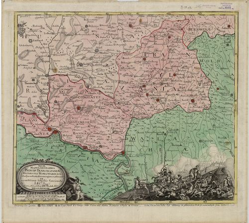
| Title | Nova Mappa Geographica Princip: Transilvaniae, Districtus Temeswariensis, et adjacentium aliarum regionum et locoru… |
| Main title | Erdély és a Temesi Bánság térképe 1788-ban. |
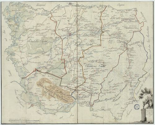
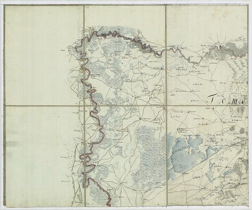
2593. [Plan des Temeswarer Bannatths… [B IX a 578]
Institute and Museum of Military History •
B IX a
•
B IX Ausztria–Magyarország
•
B I–XV. Európa
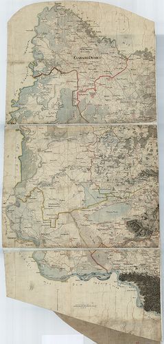
| Title | [Plan des Temeswarer Bannatths… |
| Main title | A Temesi Bánság részletes térképe 1773 körül, az I. katonai felmérés alapján. |
2594. Banater und Arad Moden: K. K. Administr. Güter und Praedien ... [B IX a 579]
Institute and Museum of Military History •
B IX a
•
B IX Ausztria–Magyarország
•
B I–XV. Európa
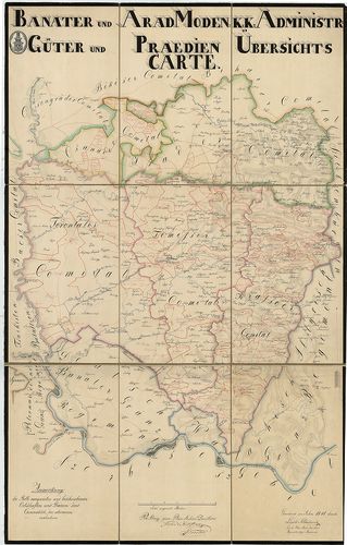
| Title | Banater und Arad Moden: K. K. Administr. Güter und Praedien Übersichts Carte. |
| Main title | Temesi Bánság valamint Arad és Csanád megye térképe 1841-ben. |
2595. Karta Bacske, Szrema, i Banata sza predlozsenima ob blagoveš... [B IX a 579/1]
Institute and Museum of Military History •
B IX a
•
B IX Ausztria–Magyarország
•
B I–XV. Európa
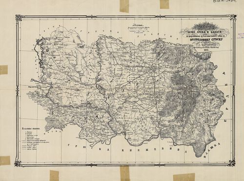
| Title | Karta Bacske, Szrema, i Banata sza predlozsenima ob blagoveštenskoga šabora za Vojvodovinu Szrbszku. |
| Main title | Bácska, Szerémség, Bánság és a Szerb Vajdaság térképe 1861-ben. |
2596. Temeschwarer Bannat. Trigonometrisch und astronomisch berich... [B IX a 579/2]
Institute and Museum of Military History •
B IX a
•
B IX Ausztria–Magyarország
•
B I–XV. Európa
| Title | Temeschwarer Bannat. Trigonometrisch und astronomisch berichtigt. |
| Main title | Temesi Bánság térképe 1788-ban, kerületi beosztással, trigonometriai és asztronómiai adatokkal. |
2597. Charte von Bannat. [B IX a 581]
Institute and Museum of Military History •
B IX a
•
B IX Ausztria–Magyarország
•
B I–XV. Európa
| Title | Charte von Bannat. |
| Main title | A Temesi Bánság általános térképe 1786 körül az I. katonai felmérés alapján. |
2598. Mappa Chorographica novissima et completissima totius Regno ... [B IX a 582]
Institute and Museum of Military History •
B IX a
•
B IX Ausztria–Magyarország
•
B I–XV. Európa
| Title | Mappa Chorographica novissima et completissima totius Regno Hungariae incorporati Bannatus Temesiensis una cum trium Comitatuum Processibus, proutet cum adiunctis Germanico Illiricis, atque Valachio Illiricis Militaribus Distribus. |
| Main title | Temesi Bánság térképe 1789 körül. |
2599. Charte des Oguliner Grenz Regiments. [B IX a 588/1]
Institute and Museum of Military History •
B IX a
•
B IX Ausztria–Magyarország
•
B I–XV. Európa
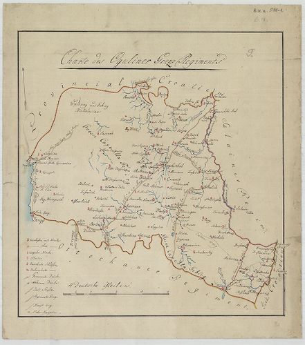
| Title | Charte des Oguliner Grenz Regiments. |
| Main title | Az Ogulini Határőrezred területének térképe a 19. század elején. |
2600. Plan des Sluiner Grenz-Regiments. [B IX a 588/2]
Institute and Museum of Military History •
B IX a
•
B IX Ausztria–Magyarország
•
B I–XV. Európa
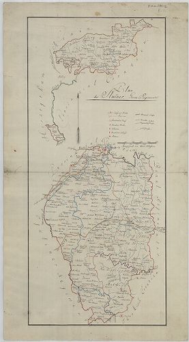
| Title | Plan des Sluiner Grenz-Regiments. |
| Main title | A Szluini Határőrezred területének térképe a 19. század elején. |