3761. Békés megye úthálózati térkép [B IX a 2640]
Institute and Museum of Military History •
B IX a 1401–2599 Magyarország megyetérképek
•
B IX Ausztria–Magyarország
•
B I–XV. Európa
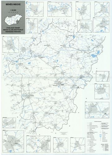
| Title | Békés megye úthálózati térkép |
| Main title | Mt: várostérképek és autópálya csomópontok; "C" változat, munkatérkép |
3762. Győr-Moson-Sopron megye [B IX a 2641]
Institute and Museum of Military History •
B IX a 1401–2599 Magyarország megyetérképek
•
B IX Ausztria–Magyarország
•
B I–XV. Európa
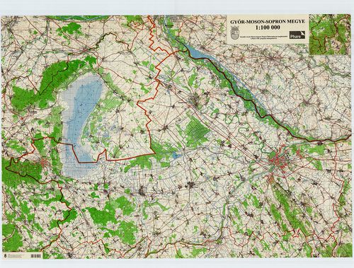
| Title | Győr-Moson-Sopron megye |
3763. Unter Neutraer Comitat. (Alsó-Nyitra vármegye.) [B IX a 2642]
Institute and Museum of Military History •
B IX a 1401–2599 Magyarország megyetérképek
•
B IX Ausztria–Magyarország
•
B I–XV. Európa
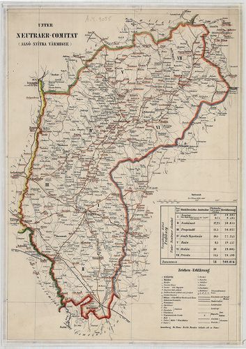
| Title | Unter Neutraer Comitat. (Alsó-Nyitra vármegye.) |
3764. Békés vármegye térképe. [B IX a 2647]
Institute and Museum of Military History •
B IX a 1401–2599 Magyarország megyetérképek
•
B IX Ausztria–Magyarország
•
B I–XV. Európa
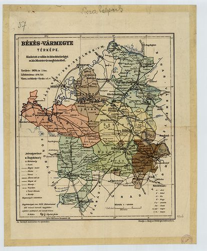
| Title | Békés vármegye térképe. |
3765. Maros-Torda vármegye. [B IX a 2653]
Institute and Museum of Military History •
B IX a 1401–2599 Magyarország megyetérképek
•
B IX Ausztria–Magyarország
•
B I–XV. Európa
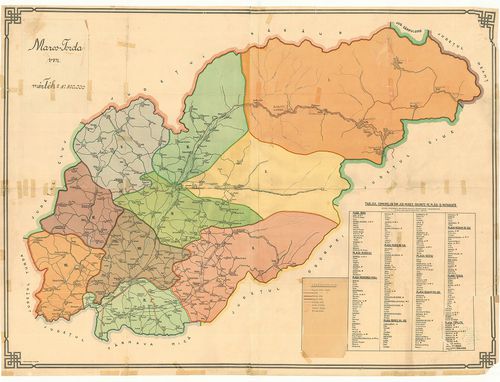
| Title | Maros-Torda vármegye. |
3766. Comitat Maramaros. [B IX a 2662]
Institute and Museum of Military History •
B IX a 1401–2599 Magyarország megyetérképek
•
B IX Ausztria–Magyarország
•
B I–XV. Európa
| Title | Comitat Maramaros. |
| Main title | Máramaros vármegye térképe. |
3767. [Szepes vármegye térképe.] [B IX a 2663]
Institute and Museum of Military History •
B IX a 1401–2599 Magyarország megyetérképek
•
B IX Ausztria–Magyarország
•
B I–XV. Európa

| Title | [Szepes vármegye térképe.] |
3768. Marmaroscher Comitat. [B IX a 2664]
Institute and Museum of Military History •
B IX a 1401–2599 Magyarország megyetérképek
•
B IX Ausztria–Magyarország
•
B I–XV. Európa
| Title | Marmaroscher Comitat. |
| Main title | Máramaros vármegye térképe. |
3769. Csík vármegye. [B IX a 2665]
Institute and Museum of Military History •
B IX a 1401–2599 Magyarország megyetérképek
•
B IX Ausztria–Magyarország
•
B I–XV. Európa
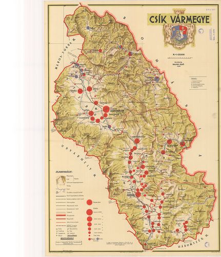
| Title | Csík vármegye. |
3770. Geognostische Karte des Beckens von Wien… [B IX b 5]
Institute and Museum of Military History •
B IX b
•
B IX Ausztria–Magyarország
•
B I–XV. Európa
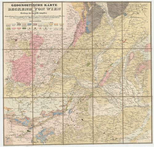
| Title | Geognostische Karte des Beckens von Wien… |
| Main title | Bécs környékének geológiai térképe 1843-ban. |
3771. Geognostische Karte des Oesterreichischen Kaiserstaates mit ... [B IX b 10]
Institute and Museum of Military History •
B IX b
•
B IX Ausztria–Magyarország
•
B I–XV. Európa
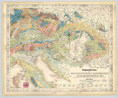
| Title | Geognostische Karte des Oesterreichischen Kaiserstaates mit einem grossen Theile Deutschland u.[nd] Italien. |
| Main title | Az Osztrák Császárság, Németország és Itália nagy részének geológiai térképe 1847-ben. |
3772. Geognostische Karte Tirols. [B IX b 11]
Institute and Museum of Military History •
B IX b
•
B IX Ausztria–Magyarország
•
B I–XV. Európa
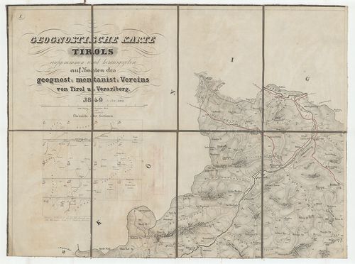
| Title | Geognostische Karte Tirols. |
| Main title | Tirol geológiai térképe 1849-ben. |
3773. Geognostische Karte der Nord-Karpathen in Schlesien … [B IX b 14]
Institute and Museum of Military History •
B IX b
•
B IX Ausztria–Magyarország
•
B I–XV. Európa
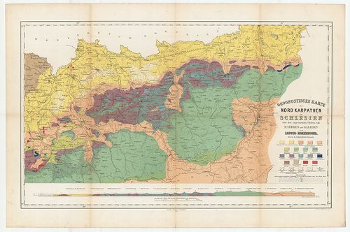
| Title | Geognostische Karte der Nord-Karpathen in Schlesien … |
| Main title | Az É-i Kárpátok külső övezetének geológiai térképe 1860-ban. |
3774. Magyar Országnak és a hozzá kaptsoltatott Horváth és Tóth or... [B IX b 16]
Institute and Museum of Military History •
B IX b
•
B IX Ausztria–Magyarország
•
B I–XV. Európa
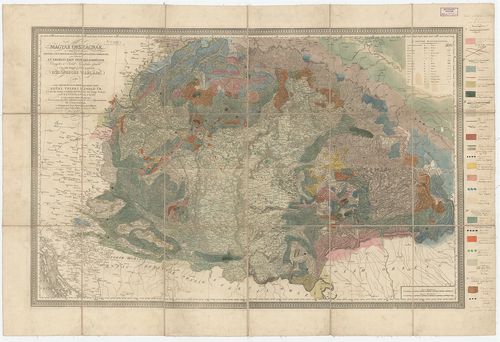
| Title | Magyar Országnak és a hozzá kaptsoltatott Horváth és Tóth országnak, ’s határőrző katonai vidékeknek nem különben az Erdélyi Fejedelemségnek Vármegyékre és Szabad Kerületekre osztatott ’s a’ legjobb mappák szerént készitetett közönséges táblája… |
| Main title | Karacs térképére Beudant rárajzolta Magyarország geológiai térképét 1818-ban. |
3775. Geologische Karte von Österreich–Ungarn… [B IX b 21]
Institute and Museum of Military History •
B IX b
•
B IX Ausztria–Magyarország
•
B I–XV. Európa
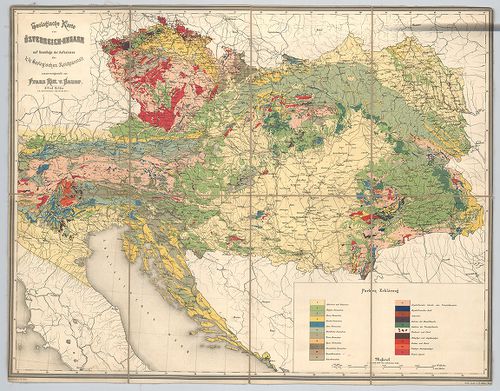
| Title | Geologische Karte von Österreich–Ungarn… |
| Main title | Ausztria–Magyarország geológiai térképe. |
3776. A selmeczi bányavidék ércztelér vonulatai. – Filons métallif... [B IX b 22/1]
Institute and Museum of Military History •
B IX b
•
B IX Ausztria–Magyarország
•
B I–XV. Európa
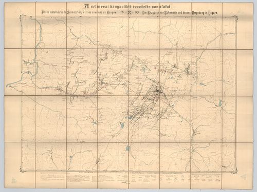
| Title | A selmeczi bányavidék ércztelér vonulatai. – Filons métalliféres de Selmeczbánya et ses environs en Hongrie. – Die Erzgänge von Schemnitz und dessen Umgebung in Ungarn. |
3777. [Magyarország] A magyar szt. korona országai területén létez... [B IX b 22/3]
Institute and Museum of Military History •
B IX b
•
B IX Ausztria–Magyarország
•
B I–XV. Európa
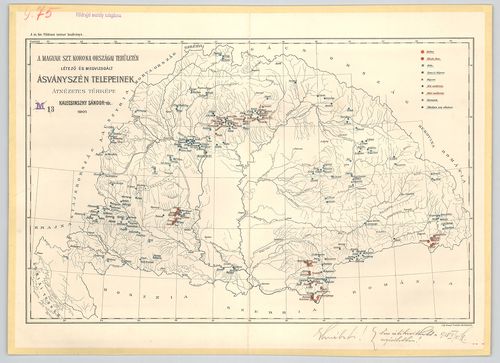
| Title | [Magyarország] A magyar szt. korona országai területén létező és megvizsgált ásványszén telepeinek átnézetes térképe. |
3778. [Magyarország] A magyar birodalom vasérc- és kőszéntelepeine... [B IX b 22/4]
Institute and Museum of Military History •
B IX b
•
B IX Ausztria–Magyarország
•
B I–XV. Európa
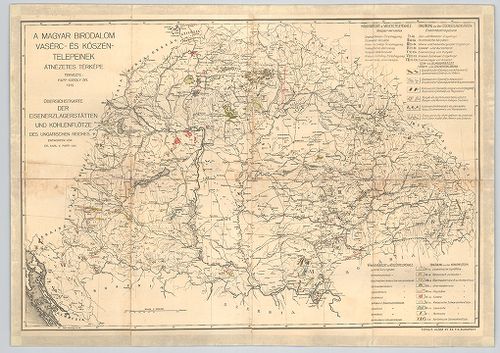
| Title | [Magyarország] A magyar birodalom vasérc- és kőszéntelepeinek átnézetes térképe. – Übersichstkarte der Eisenerzlagerstätten und Kohlenflötze des Ungarischen Reiches. |
3779. Du fer. Production et valeur. [B IX b 22/5]
Institute and Museum of Military History •
B IX b
•
B IX Ausztria–Magyarország
•
B I–XV. Európa
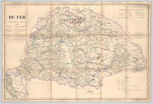
| Title | Du fer. Production et valeur. |
| Main title | Magyarország vasérc-lelőhelyei és értékük frankban kifejezve 1856-ban és 1876-ban. |
3780. A körmöczi bányavidék földtani viszonyai bányageológiai szem... [B IX b 22/6]
Institute and Museum of Military History •
B IX b
•
B IX Ausztria–Magyarország
•
B I–XV. Európa
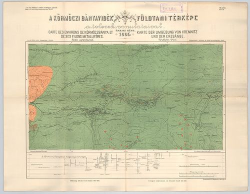
| Title | A körmöczi bányavidék földtani viszonyai bányageológiai szempontból. – Die Geologischen verhältnisse des Kremnitzer Bergbaugebietes von Montangeologischen standpunkte. XI. köt. 4. füz. Atlasz. |
| Main title | 2 térk. mell. 1. VII. tábl. A körmöczi bányavidék földtani térképe a telerek vonulataival. É-i rész 1895. – Carte des environs de Körmöczbánya et de ses filons métalliféres. Partie septentrional. Karte des Umgebung von Kremnitz und der Erzgänge. Nördlicher Theil. |
| Subject | 2. VIII. tábla. A körmöczi bányavidék földtani térképe a Nándor altáró kitüntetésével. Déli rész 1895. – Carte des environs de Körmöczbánya avec la galérie d’ecoulement nommée galérie Nándor. Partie meridionale 1895. – Karte der Umgebung von Kremnitz mit dem Ferdinand erbstollen. Südlicher Theil 1895. |