3841. Übersichtskarte der Bertiebslinien der Ersten k. k. priv. Do... [B IX b 125/7]
Institute and Museum of Military History •
B IX b
•
B IX Ausztria–Magyarország
•
B I–XV. Európa
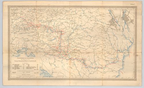
| Title | Übersichtskarte der Bertiebslinien der Ersten k. k. priv. Donau-Dampfschiffahrts-Gesellschaft. |
| Main title | 2 mt. 1. Wien. 2. Buda-Pest. |
| Subject | A Duna hajózható szakaszának áttekintő térképe 1891-ben. |
3842. Az Alduna hajózási akadályainak átnézete. Készítette 1896. é... [B IX b 125/8]
Institute and Museum of Military History •
B IX b
•
B IX Ausztria–Magyarország
•
B I–XV. Európa
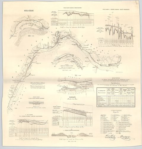
| Title | Az Alduna hajózási akadályainak átnézete. Készítette 1896. évben az Aldunai Vaskapuszabályozási M. Kir. művezetőség. – Plan général des cataractes du Bas-Danube. Dressé en 1896 par la Direction royale hongroise des travaux de regularisation. |
3843. Carte du cours du Danube depuis Ulm jusqu’a son embouchure d... [B IX b 126]
Institute and Museum of Military History •
B IX b
•
B IX Ausztria–Magyarország
•
B I–XV. Európa
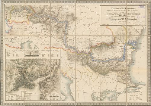
| Title | Carte du cours du Danube depuis Ulm jusqu’a son embouchure dans La Mer noire ou Guide de Voyage a Constantinople sur le Danube avec indication de tout ce qui a rapport Navigation des ála Piroscaphes sur cette route. |
| Main title | Mt: Plan de Constantinople (Konstantinápoly térképe) |
| Subject | A Duna térképe Ulmtól a torkolatig, a parti települések feltüntetésével. |
3844. Copia. Der von Löbl Bacser Comitat dem Slavonischen General ... [B IX b 128]
Institute and Museum of Military History •
B IX b
•
B IX Ausztria–Magyarország
•
B I–XV. Európa
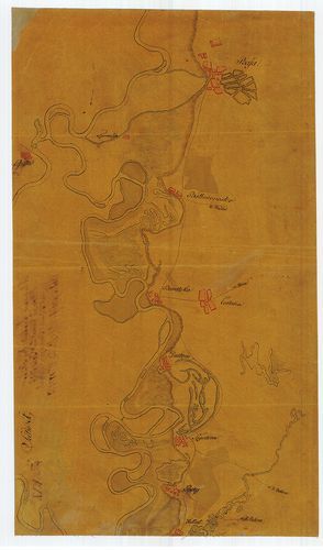
| Title | Copia. Der von Löbl Bacser Comitat dem Slavonischen General Commando zugemittelten Strohm Charte der Donau von Baja bis Carlovitz; der Theiss von Martonyos bis Csurugh und des Franz Canals von Monostorszegh bis Földvár. |
| Main title | A Duna és a Tisza Bács megyei szakaszának térképe a Ferenc-csatornával 1811-ben. |
3845. Plan des Donau-Strommes Von Wien bis Orshova-[Rostzig] zusam... [B IX b 128/1]
Institute and Museum of Military History •
B IX b
•
B IX Ausztria–Magyarország
•
B I–XV. Európa
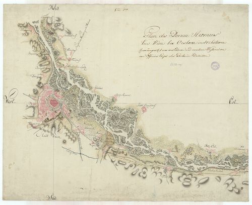
| Title | Plan des Donau-Strommes Von Wien bis Orshova-[Rostzig] zusammengesetzt aus verschiedenen und mehreren Wasserreisen vom Officiers-Corps des Pontoniers-Bataillons. |
| Main title | A Duna folyam Bécs-Orsova-Rusze között. |
3846. Plan des Donau-Stroms von St. Johann bis Pressburg. [B IX b 131]
Institute and Museum of Military History •
B IX b
•
B IX Ausztria–Magyarország
•
B I–XV. Európa
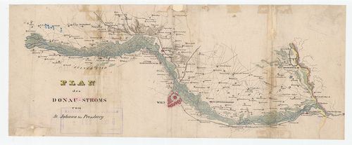
| Title | Plan des Donau-Stroms von St. Johann bis Pressburg. |
| Main title | A Duna Tulln és Pozsony között. |
3847. Hydrographisch-topographische Ubersichts Karte des Donau Str... [B IX b 132]
Institute and Museum of Military History •
B IX b
•
B IX Ausztria–Magyarország
•
B I–XV. Európa

| Title | Hydrographisch-topographische Ubersichts Karte des Donau Stromes. |
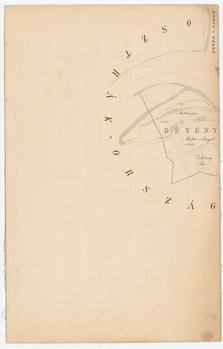
| Main title | A Duna szabályozásának tervrajza 1833–36-os felmérések szerint Dévény és Vének között. |
3848. Plan der Donau von Pesth bis Orsova. [B IX b 133]
Institute and Museum of Military History •
B IX b
•
B IX Ausztria–Magyarország
•
B I–XV. Európa
| Title | Plan der Donau von Pesth bis Orsova. |
| Main title | A Duna Pest és Orsova között 1820 körül. |
3849. Donau Atlas. Hydrographische Donau Karte von Peterwardein [r... [B IX b 134]
Institute and Museum of Military History •
B IX b
•
B IX Ausztria–Magyarország
•
B I–XV. Európa
| Title | Donau Atlas. Hydrographische Donau Karte von Peterwardein [rossz cím, valójában: Pressburg] bis Orschova. |
| Main title | A Duna térképe Pozsonytól – Orsováig. |
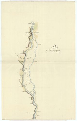
3850. [A Duna helyszínrajzi térképe Dévénytől – Nagymarosig. [B IX b 136]
Institute and Museum of Military History •
B IX b
•
B IX Ausztria–Magyarország
•
B I–XV. Európa
| Title | [A Duna helyszínrajzi térképe Dévénytől – Nagymarosig. |
3851. Carte réduite du cours du Danube de la Mer Noire et de la Me... [B IX b 137]
Institute and Museum of Military History •
B IX b
•
B IX Ausztria–Magyarország
•
B I–XV. Európa
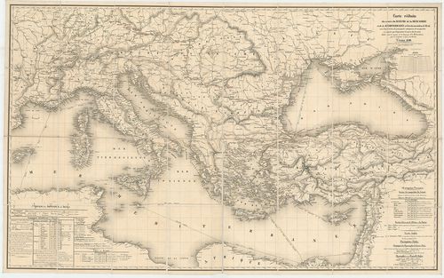
| Title | Carte réduite du cours du Danube de la Mer Noire et de la Mediterranée… |
| Main title | A Duna folyó, a Fekete-tenger és a Földközi-tenger térképe a legfontosabb gőzhajóútvonalak feltüntetésével 1840-ben. |
3852. Karten der Donaustromes innerhalb der österr. Kaiserstaates. [B IX b 138]
Institute and Museum of Military History •
B IX b
•
B IX Ausztria–Magyarország
•
B I–XV. Európa
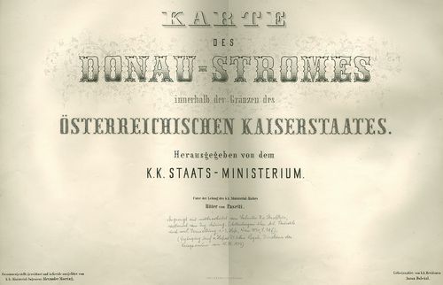
| Title | Karten der Donaustromes innerhalb der österr. Kaiserstaates. |
| Main title | A Duna Passautól Orsováig. |
3853. Plan der Donau-Regulirung bei Wien… [B IX b 138/1]
Institute and Museum of Military History •
B IX b
•
B IX Ausztria–Magyarország
•
B I–XV. Európa

| Title | Plan der Donau-Regulirung bei Wien… |
| Main title | A Duna szabályozásának terve Bécsnél. |
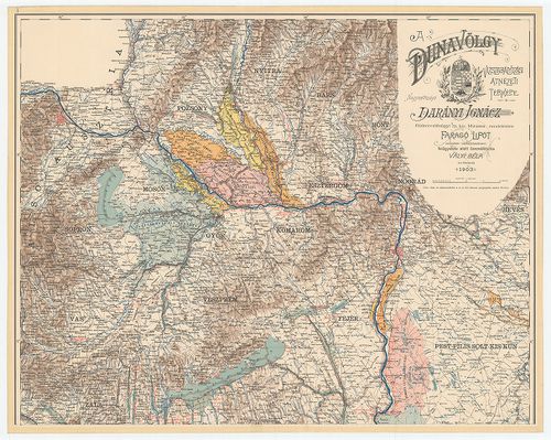
3854. A Dunavölgy átnézeti térképe. Összeállította: Vályi Béla az ... [B IX b 139/1]
Institute and Museum of Military History •
B IX b
•
B IX Ausztria–Magyarország
•
B I–XV. Európa
| Title | A Dunavölgy átnézeti térképe. Összeállította: Vályi Béla az 1898. dec. 31-i állapotnak megfelelően. |
3855. A Dunavölgy vízszabályozási átnézeti térképe. Összeállította... [B IX b 139/2]
Institute and Museum of Military History •
B IX b
•
B IX Ausztria–Magyarország
•
B I–XV. Európa
| Title | A Dunavölgy vízszabályozási átnézeti térképe. Összeállította: Vályi Béla. |
3856. A Duna folyam hossz-szelvénye Magyarországban. – Profil en l... [B IX b 139/4]
Institute and Museum of Military History •
B IX b
•
B IX Ausztria–Magyarország
•
B I–XV. Európa
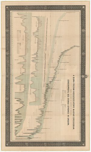
| Title | A Duna folyam hossz-szelvénye Magyarországban. – Profil en long du Danube en Hongrie. – Längenprofil der Donau in Ungarn. (Pozsonytól – Islasig) |
3857. [A Duna és a Tisza folyamszabályozási térképe.] Plans et des... [B IX b 143]
Institute and Museum of Military History •
B IX b
•
B IX Ausztria–Magyarország
•
B I–XV. Európa
| Title | [A Duna és a Tisza folyamszabályozási térképe.] Plans et dessins annaxés aux rapport de la commission composée des ingenieurs étrangers… A hazai folyókon végrehajtott szabályozási munkálatok megbírálására meghívott, külföldi szakértőkből alakult bizottság jelentéseihez mellékelt térképek és tervrajzok. |
3858. Plan des Schiffahrts, Canals wodurch die Donau mit der Theis... [B IX b 145/1]
Institute and Museum of Military History •
B IX b
•
B IX Ausztria–Magyarország
•
B I–XV. Európa
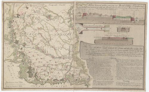
| Title | Plan des Schiffahrts, Canals wodurch die Donau mit der Theis in dem Batcser… |
| Main title | A Duna–Tisza közti hajózható csatorna (Ferenc-csatorna, Bácskai- nagy-csatorna) térképe 1816-ban, Bajától-Titelig. |
3859. Nacrt za odbranu od poplave. [B IX b 152]
Institute and Museum of Military History •
B IX b
•
B IX Ausztria–Magyarország
•
B I–XV. Európa
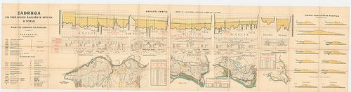
| Title | Nacrt za odbranu od poplave. |
| Main title | Duna árvédelmi térképvázlat Titelnél 1880 körül. |
3860. Das Innthal von Zirl bis zur Brücke bei Volders. [B IX b 153]
Institute and Museum of Military History •
B IX b
•
B IX Ausztria–Magyarország
•
B I–XV. Európa
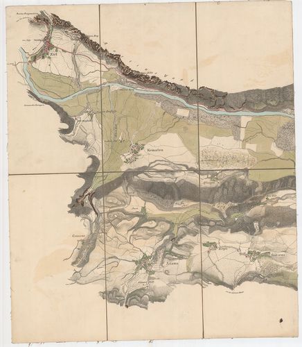
| Title | Das Innthal von Zirl bis zur Brücke bei Volders. |
| Main title | Az Inn folyó völgye Zirltől a Volders-i hídig 1839 körül. |