4501. Eisenbahn-Karte der Österreichisch–Ungarischen Monarchie. [B IX c 1389]
Institute and Museum of Military History •
B IX c
•
B IX Ausztria–Magyarország
•
B I–XV. Európa
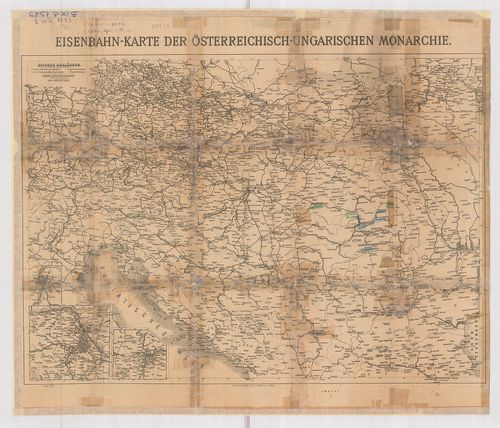
| Title | Eisenbahn-Karte der Österreichisch–Ungarischen Monarchie. |
| Main title | 2 mt.: 1.) Bezirke de Stadt Wien. 2.) Prager Stadtviertel. A hátoldalon: Eisenbahn-Karte von Mittel-Europa. |
| Subject | Az Osztrák–Magyar Monarchia és Közép-Európa vasúti térképe. |
4502. Eisenbahnkarte der Österreichisch–Ungarischen Monarchie. [B IX c 1390]
Institute and Museum of Military History •
B IX c
•
B IX Ausztria–Magyarország
•
B I–XV. Európa
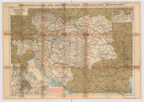
| Title | Eisenbahnkarte der Österreichisch–Ungarischen Monarchie. |
| Main title | 2 mt.: 1.) Bezirke der Stadt Wien. 2.) Prager Stadtviertel. A hátoldalon: Eisenbahn-routen-karte von Mittel-Europa. |
| Subject | Az Osztrák–Magyar Monarchia és Közép-Európa vasúti térképe. |
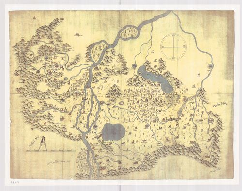
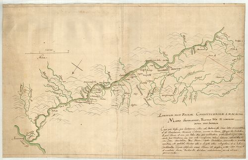
4503. Mappa Lineae Limitaneae Utriusq Imperiy Caesarei et Ottomani... [B IX c 1392]
Institute and Museum of Military History •
B IX c
•
B IX Ausztria–Magyarország
•
B I–XV. Európa
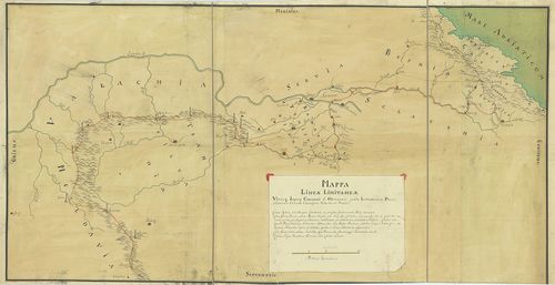
| Title | Mappa Lineae Limitaneae Utriusq Imperiy Caesarei et Ottomanici juxta Instrumentum Pacis Statuum in Conventu Carlovitzensi, Valachis et Venetis. |
| Main title | A karlócai békeszerződés határvonala a Császári Birodalom és a Török Birodalom között. |
4504. Festungs Sections Plan: 1.) von Raibl. [B IX c 1393]
Institute and Museum of Military History •
B IX c
•
B IX Ausztria–Magyarország
•
B I–XV. Európa
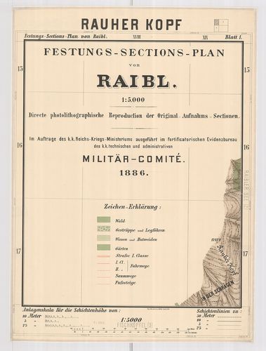
| Title | Festungs Sections Plan: 1.) von Raibl. |
| Main title | 2.) der Sperre Flitsch |
| Subject | 3.) von Predil. |
4505. Tabula Generalis Universa Regni Hungariae, Slavoniae ac S˙rm... [B IX c 1395]
Institute and Museum of Military History •
B IX c
•
B IX Ausztria–Magyarország
•
B I–XV. Európa
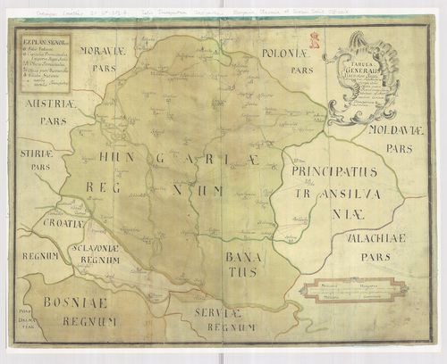
| Title | Tabula Generalis Universa Regni Hungariae, Slavoniae ac S˙rmü Salis Officia… |
| Main title | A Magyar Királyság, Szlavónia általános térképe, jelölve a sószállító útvonalakat. |
4506. Exhibeus partem Fluvy Tübisci ... [B IX c 1396]
Institute and Museum of Military History •
B IX c
•
B IX Ausztria–Magyarország
•
B I–XV. Európa
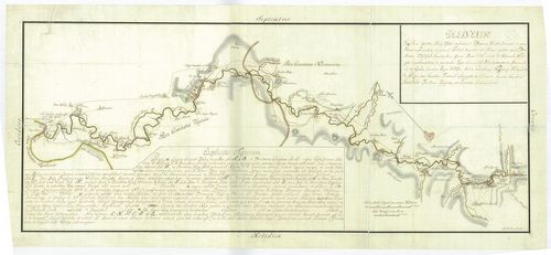
| Title | Exhibeus partem Fluvy Tübisci ... |
| Main title | A Tisza Bocskó és Tiszaújlak közötti szakasza a folyó menti betelepülések jelölésével. A sószállítóútvonalak átrakodóhelyek jelölve. (eredeti térkép OL) |
4507. Dislocations Karte der im Königreich Hungarn bequartirten K.... [B IX c 1397]
Institute and Museum of Military History •
B IX c
•
B IX Ausztria–Magyarország
•
B I–XV. Európa
| Title | Dislocations Karte der im Königreich Hungarn bequartirten K. Königleichen Truppen. |
| Main title | A Magyar Királyság diszlokációs térképe a királyi csapatok szálláshelyeivel. |
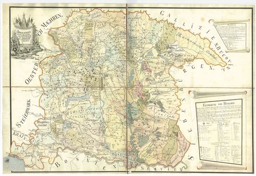
4508. General-Charte des Königreich Hungarn min Einbegriß des Teme... [B IX c 1398]
Institute and Museum of Military History •
B IX c
•
B IX Ausztria–Magyarország
•
B I–XV. Európa
| Title | General-Charte des Königreich Hungarn min Einbegriß des Temeswarer Banat, des Königreich Slavonien und Croatien in 54 Comitate ... |
| Main title | A Magyar Királyság általános térképe a Temesi-Bánsággal, Szlavóniával és Horvátországgal, 54 megyére osztva. A területek mozgósítási táblázata. |
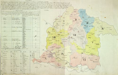
4509. Militär-Territorial-Benörden und Dislokation des Heeresim Fe... [B IX c 1399]
Institute and Museum of Military History •
B IX c
•
B IX Ausztria–Magyarország
•
B I–XV. Európa
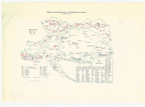
| Title | Militär-Territorial-Benörden und Dislokation des Heeresim Februar 1848. |
| Main title | A csapatok diszlokációja és az elhelyezési körzetek. |
4510. Ergänzungsbezirks-Eintheilung der Jäger-Truppen. [B IX c 1400]
Institute and Museum of Military History •
B IX c
•
B IX Ausztria–Magyarország
•
B I–XV. Európa
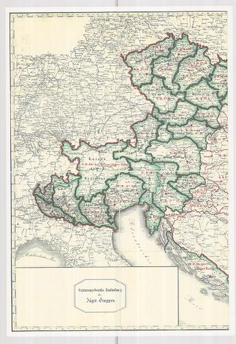
| Title | Ergänzungsbezirks-Eintheilung der Jäger-Truppen. |
| Main title | A vadász-csapatok területi elhelyezkedése. |
4511. Aufnahmskarte der wirklichen Grenzen zwischen dem Königreic... [B IX c 1402]
Institute and Museum of Military History •
B IX c
•
B IX Ausztria–Magyarország
•
B I–XV. Európa
| Title | Aufnahmskarte der wirklichen Grenzen zwischen dem Königreich Ungarn u. dem Erzherzoghtum Österreich unter der Ens.... |
| Main title | A Magyar Királyság határtérképe Alsó-Ausztria felé. |
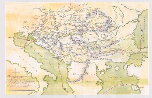
4512. Mappa Geographica Transylvaniam a Banatu Temisvariensi Separ... [B IX c 1404]
Institute and Museum of Military History •
B IX c
•
B IX Ausztria–Magyarország
•
B I–XV. Európa
| Title | Mappa Geographica Transylvaniam a Banatu Temisvariensi Separantes Limites... |
| Main title | Erdély és a Temesi Bánság földrajzi térképe a határok feltüntetésével. Határtérkép. |
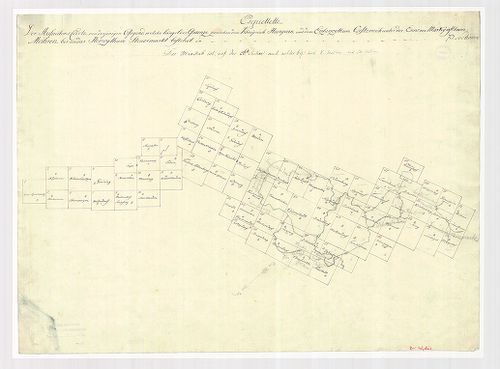
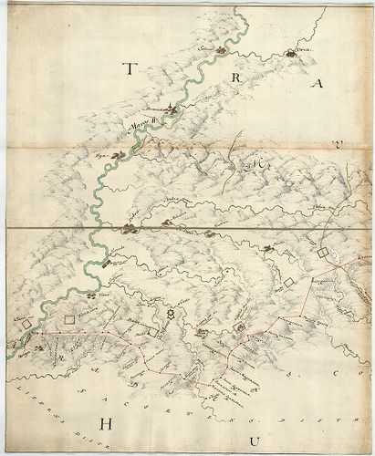
4513. [A törökellenes magyarországi határvédelem térképe.] [B IX c 1407]
Institute and Museum of Military History •
B IX c
•
B IX Ausztria–Magyarország
•
B I–XV. Európa
| Title | [A törökellenes magyarországi határvédelem térképe.] |
4514. [Mappa Mercantilis] - Mappa Geographica facta in usum Commer... [B IX c 1408]
Institute and Museum of Military History •
B IX c
•
B IX Ausztria–Magyarország
•
B I–XV. Európa
| Title | [Mappa Mercantilis] - Mappa Geographica facta in usum Commerciorum. |
| Main title | Földrajzi térkép, amely kereskedők használatára készült.[Kereskedelmi térkép]. |
4515. Magyarország vízierői 1897–1903. évi fölvételének körébe von... [B IX c 1412]
Institute and Museum of Military History •
B IX c
•
B IX Ausztria–Magyarország
•
B I–XV. Európa
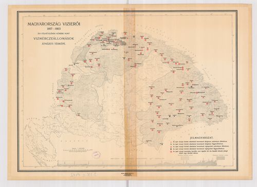
| Title | Magyarország vízierői 1897–1903. évi fölvételének körébe vont vízmérceállomások átnézeti térképe. |
4516. A Pilis és Dobogókő környéke [B IX c 1418]
Institute and Museum of Military History •
B IX c
•
B IX Ausztria–Magyarország
•
B I–XV. Európa
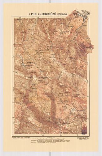
| Title | A Pilis és Dobogókő környéke |
4517. A gazdaságok területének megoszlása nagyságkategóriák szerin... [B IX c 1419]
Institute and Museum of Military History •
B IX c
•
B IX Ausztria–Magyarország
•
B I–XV. Európa
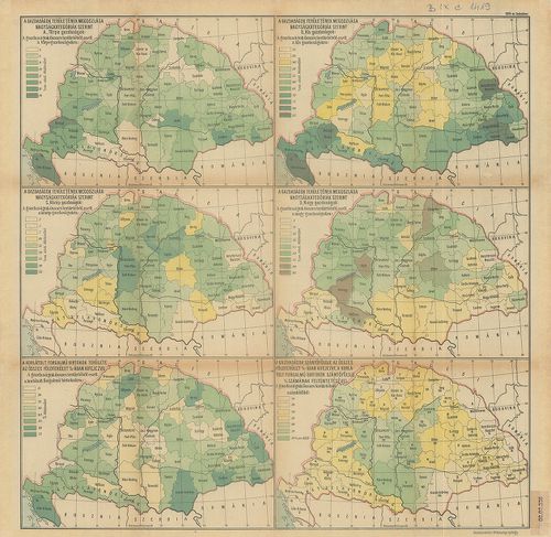
| Title | A gazdaságok területének megoszlása nagyságkategóriák szerint. 6 térkép, statisztikai adatokkal. |
4518. Magyarország gazdaságföldrajzi térképe. [B IX c 1420]
Institute and Museum of Military History •
B IX c
•
B IX Ausztria–Magyarország
•
B I–XV. Európa
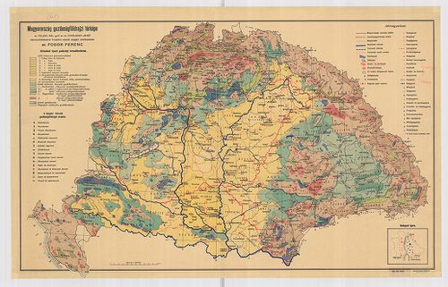
| Title | Magyarország gazdaságföldrajzi térképe. |
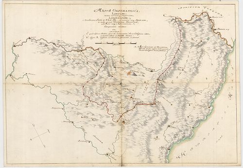
4519. Limitum post Pacem Carlovitcensem A MDCXCVIII. Mappa Geograp... [B IX c 1421]
Institute and Museum of Military History •
B IX c
•
B IX Ausztria–Magyarország
•
B I–XV. Európa
| Title | Limitum post Pacem Carlovitcensem A MDCXCVIII. Mappa Geographica, Tractus Unnae fl. Limitanei inter duo Imperia. |
| Main title | Az 1698. (sic!) évi Karlócai békeszerződés utáni határok földrajzi térképe, amely az Una folyónak a két birodalom közötti határszakaszát ábrázolja. Határtérkép. |
4520. Mappa Geographica; Lineam, inter utrumque Imperium, Limitane... [B IX c 1423]
Institute and Museum of Military History •
B IX c
•
B IX Ausztria–Magyarország
•
B I–XV. Európa
| Title | Mappa Geographica; Lineam, inter utrumque Imperium, Limitaneam, a Confluxu Savi et Unae ffl., ad montem usque Popinam, ad Mare usque Adriaticum; Compendiose exhibens |
| Main title | Földrajzi térkép, amely a két birodalom határvonalát a Száva és az Una folyók torkolatától a Popina hegyig, és innen a velencei fennhatóságú területekig, egészen az Adriai tengerig, vázlatosan bemutatja. Határtérkép. |