441. G. Freytags Übersichtskarte des Deutsch–Französischen Kriegs... [B II c 193]
Institute and Museum of Military History •
B II c
•
B II Európa, nagyobb részek és országcsoportok
•
B I–XV. Európa
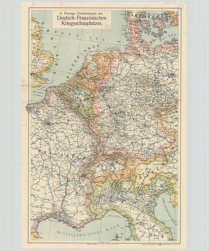
| Title | G. Freytags Übersichtskarte des Deutsch–Französischen Kriegsschauplatzes. |
| Main title | A német–francia hadszíntér az I. világháború idején. |
442. Bereiche der Feldtransportleitungen in Österreich–Ungarn und... [B II c 194]
Institute and Museum of Military History •
B II c
•
B II Európa, nagyobb részek és országcsoportok
•
B I–XV. Európa
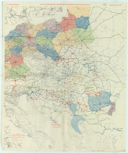
| Title | Bereiche der Feldtransportleitungen in Österreich–Ungarn und der anschliessenden deutschen Linienkommandanturen. |
| Main title | Az Osztrák–Magyar Monarchia harctéri szállítási útvonalainak a területe és a csatlakozó német vonalparancsnokságok. |
443. Germany. Map of the occupation areas. [B II c 197]
Institute and Museum of Military History •
B II c
•
B II Európa, nagyobb részek és országcsoportok
•
B I–XV. Európa
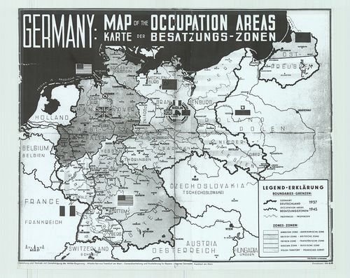
| Title | Germany. Map of the occupation areas. |
| Main title | Németország. A megszállási övezetek térképe 1945-ben. |
444. Map of the occupation areas. [B II c 198]
Institute and Museum of Military History •
B II c
•
B II Európa, nagyobb részek és országcsoportok
•
B I–XV. Európa
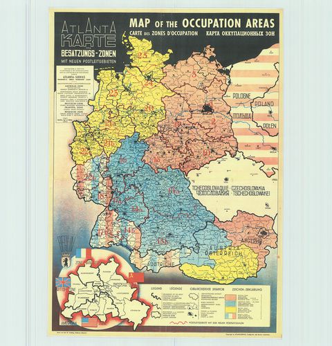
| Title | Map of the occupation areas. |
| Main title | A megszállási övezetek térképe 1945-ben. |
445. Mittel-Eurpa (von Paris bis Petersburg vom kattegat bis Vene... [B II c 200]
Institute and Museum of Military History •
B II c
•
B II Európa, nagyobb részek és országcsoportok
•
B I–XV. Európa
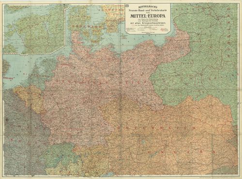
| Title | Mittel-Eurpa (von Paris bis Petersburg vom kattegat bis Venedig) mit allen Kriegsschauplatzen. |
| Main title | 1 mt.: a Finn öböl. |
| Subject | Közép-Európa (Párizstól Pétervárig, Kattegattól Velencéig) hadszínterei (és a megszált területek) 1915. |
446. Südeuropa Ostblatt. Sträßenkarte. [B II c 201]
Institute and Museum of Military History •
B II c
•
B II Európa, nagyobb részek és országcsoportok
•
B I–XV. Európa
| Title | Südeuropa Ostblatt. Sträßenkarte. |
| Main title | Dél-Európa (K-i szelvény) úttérképe. |
447. Bradshaw’s Railway Map of Central Europe. [B II c 204]
Institute and Museum of Military History •
B II c
•
B II Európa, nagyobb részek és országcsoportok
•
B I–XV. Európa
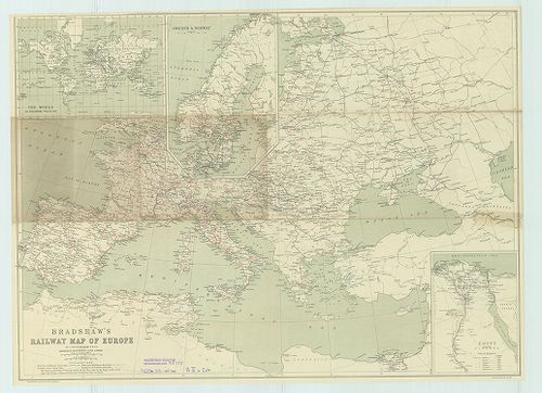
| Title | Bradshaw’s Railway Map of Central Europe. |
| Main title | Közép-Európa vasúti térképe. |
448. Ostalpenländer. [B II c 205]
Institute and Museum of Military History •
B II c
•
B II Európa, nagyobb részek és országcsoportok
•
B I–XV. Európa
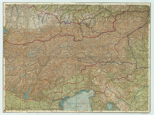
| Title | Ostalpenländer. |
| Main title | A Keleti Alpok autótérképe. |
449. Közép-Európa nemzetiségi térképe. [B II c 207]
Institute and Museum of Military History •
B II c
•
B II Európa, nagyobb részek és országcsoportok
•
B I–XV. Európa
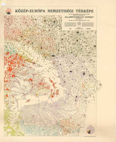
| Title | Közép-Európa nemzetiségi térképe. |
450. Etnographische Karte von Mitteleuropa. [B II c 208]
Institute and Museum of Military History •
B II c
•
B II Európa, nagyobb részek és országcsoportok
•
B I–XV. Európa
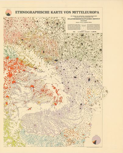
| Title | Etnographische Karte von Mitteleuropa. |
| Main title | Közép-Európa nemzetiségi térképe, németül |
451. Etnographical Map of Central Europe. [B II c 209]
Institute and Museum of Military History •
B II c
•
B II Európa, nagyobb részek és országcsoportok
•
B I–XV. Európa
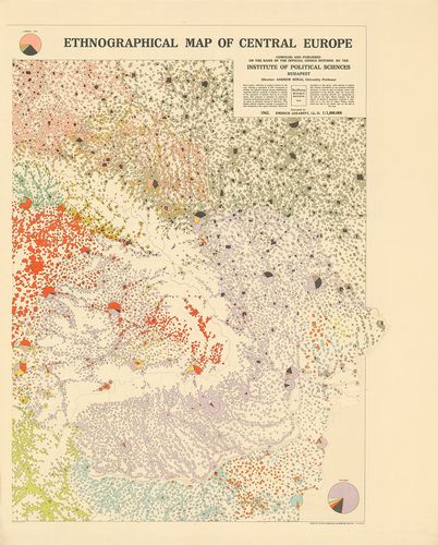
| Title | Etnographical Map of Central Europe. |
| Main title | Közép-Európa nemzetiségi térképe, angolul. |
452. Carte Etnographique de l´Europa Centrale. [B II c 210]
Institute and Museum of Military History •
B II c
•
B II Európa, nagyobb részek és országcsoportok
•
B I–XV. Európa
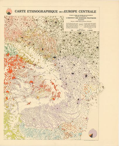
| Title | Carte Etnographique de l´Europa Centrale. |
| Main title | Közép-Európa nemzetiségi térképe, franciául. |
453. Carta Etnica dell´Europa Centrale. [B II c 211]
Institute and Museum of Military History •
B II c
•
B II Európa, nagyobb részek és országcsoportok
•
B I–XV. Európa
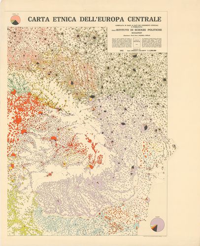
| Title | Carta Etnica dell´Europa Centrale. |
| Main title | Közép-Európa nemzetiségi térképe, olaszul. |
454. Bereiche der Feldtransportleitungen, der Eisenbahnlinien kom... [B II c 212]
Institute and Museum of Military History •
B II c
•
B II Európa, nagyobb részek és országcsoportok
•
B I–XV. Európa
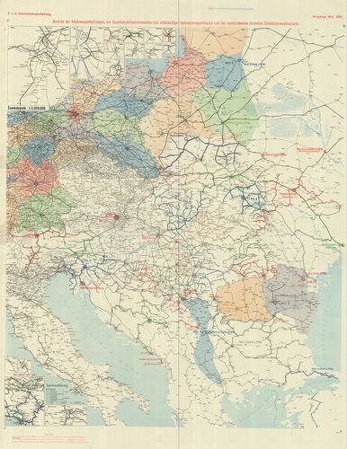
| Title | Bereiche der Feldtransportleitungen, der Eisenbahnlinien kommandos mit selbständiger Instradierungsbefugnis und der anschliessenden deutschen Linienkommandaturen. |
| Main title | A központi hatalmak katonai szállításvezetőségeinek hálózati térképe 1918. máj. |
455. Carte Ethnographique des pays Danubiens. [B II c 213]
Institute and Museum of Military History •
B II c
•
B II Európa, nagyobb részek és országcsoportok
•
B I–XV. Európa
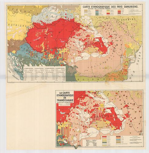
| Title | Carte Ethnographique des pays Danubiens. |
| Main title | Mt. La Carte Ethnographique de Transylvanie. (Erdély néprajzi térképe. |
| Subject | A Duna-medence néprajzi térképe 1928 körül. |
456. Kriegskarte. Nr. 165. Die militär. Ereignisse von 26. Nov. b... [B II c 214]
Institute and Museum of Military History •
B II c
•
B II Európa, nagyobb részek és országcsoportok
•
B I–XV. Európa
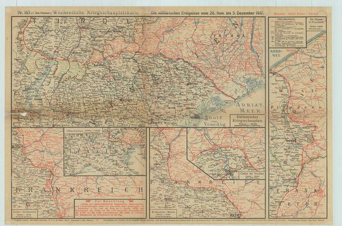
| Title | Kriegskarte. Nr. 165. Die militär. Ereignisse von 26. Nov. bis 5. Dezember 1917. |
| Main title | Térképek az I. világháború hadszíntereiről 1917. nov. 26ésdec. 5. között. |
457. Az orosz harctér. A front állása: 1915. május 1-én. 1916. jú... [B II c 215]
Institute and Museum of Military History •
B II c
•
B II Európa, nagyobb részek és országcsoportok
•
B I–XV. Európa
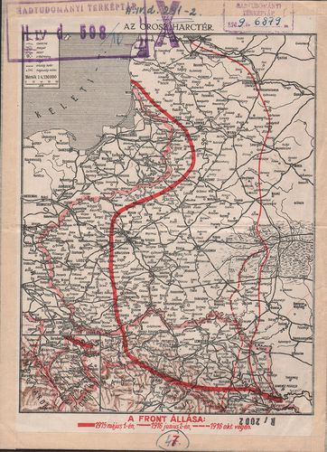
| Title | Az orosz harctér. A front állása: 1915. május 1-én. 1916. június 1.-én. 1916. október végén. A hátoldalon: Az olasz harctér. A nyugati harctér. A balkáni harctér. |
458. Neueste Karte der Koenigreiche Bosnien, Servien, Croatien un... [B III a 1]
Institute and Museum of Military History •
B III a
•
B III Balkán-félsziget
•
B I–XV. Európa
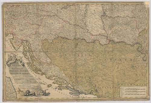
| Title | Neueste Karte der Koenigreiche Bosnien, Servien, Croatien und Slavonien… einem grossen Theil von Ungarn, Siebenbürgen, Wallachei, Bulgarien, Albanien, Macedonien. … |
| Main title | Bosznia, Szerbia, Horvát-Szlavónia térképe 1788-ban. |
459. Die Staten der Balkan-Halbinsel nach den Grenzbestimmungen d... [B III a 2]
Institute and Museum of Military History •
B III a
•
B III Balkán-félsziget
•
B I–XV. Európa
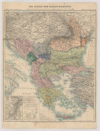
| Title | Die Staten der Balkan-Halbinsel nach den Grenzbestimmungen des Friedens von Hagios Stephano (St. Stefano). |
| Main title | Mt.: Constantinopel und der Bosporus. (Istanbul és a Boszporusz.)A Balkán-félsziget 1878. márc. 2-i St. Stefanoi béke utáni határ kijelölésének térképe. (Bulgária 1878 utáni határát piros ceruzával jelölték.) |
460. Kommunikationskarte von Serbien. [B III a 3]
Institute and Museum of Military History •
B III a
•
B III Balkán-félsziget
•
B I–XV. Európa
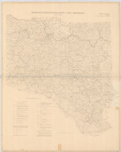
| Title | Kommunikationskarte von Serbien. |
| Main title | Szerbia közlekedési térképe 1905-ben. |