4901. Northern trans-frontier. Parts of Russian, Turkistán, Afghán... [B XI c 173]
Institute and Museum of Military History •
B XI c
•
B XI Oroszország
•
B I–XV. Európa
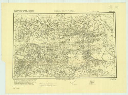
| Title | Northern trans-frontier. Parts of Russian, Turkistán, Afghánistán, Chitrál, Kanjut and Chinese territory. Sheet No. 2. – No. 69. S. 98. |
| Main title | A Pamír-fennsík környéke az Oroszország, Afganisztán, Nyugat-Pakisztán, Kína és India közötti határvidék térképe 1898-ban. |
4902. Kievszkoe goszudarsztvo-ego szoszedi v IX–XI vekah. [B XI c 178]
Institute and Museum of Military History •
B XI c
•
B XI Oroszország
•
B I–XV. Európa
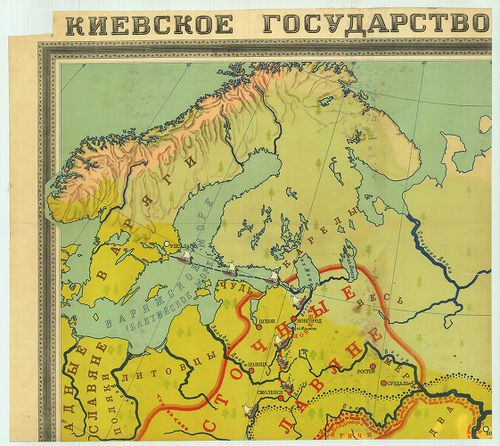
| Title | Kievszkoe goszudarsztvo-ego szoszedi v IX–XI vekah. |
| Main title | Kijev és a szomszédos államok a IX–XI. században. |
4903. Orosz fogolytáborok. [B XI c 183]
Institute and Museum of Military History •
B XI c
•
B XI Oroszország
•
B I–XV. Európa

| Title | Orosz fogolytáborok. |
| Main title | A Szovjetunió területén lévő fogolytáborok az I. Világháború után. |
4904. Tatry. (Część polska.) mapa fotogrametryczna. Widanie Narcia... [B XI c 236]
Institute and Museum of Military History •
B XI c
•
B XI Oroszország
•
B I–XV. Európa
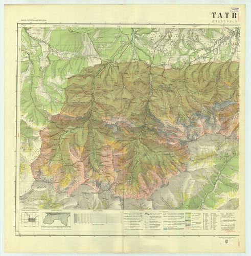
| Title | Tatry. (Część polska.) mapa fotogrametryczna. Widanie Narciarskie. |
| Main title | A Lengyel Tátra télisport térképe 1938-ban. |
4905. Tatry. (Część polska.) Mapa fotogrametryczna. Wydanie turyst... [B XI c 237]
Institute and Museum of Military History •
B XI c
•
B XI Oroszország
•
B I–XV. Európa
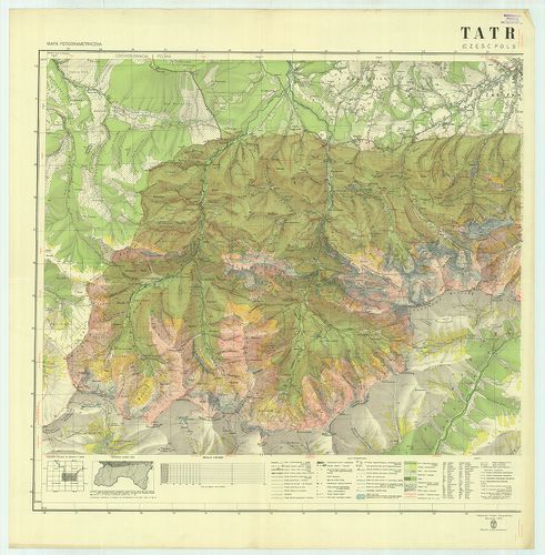
| Title | Tatry. (Część polska.) Mapa fotogrametryczna. Wydanie turystyczne. |
| Main title | A Lengyel Tátra turistatérképe 1938-ban. |
4906. Dislokation der Truppen und Anstalten im Gouvernementbereich... [B XI c 265]
Institute and Museum of Military History •
B XI c
•
B XI Oroszország
•
B I–XV. Európa
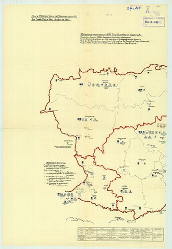
| Title | Dislokation der Truppen und Anstalten im Gouvernementbereiche. |
| Main title | A csapatok és intézmények diszlokációja. |
4907. Westrussland. [B XI c 267]
Institute and Museum of Military History •
B XI c
•
B XI Oroszország
•
B I–XV. Európa
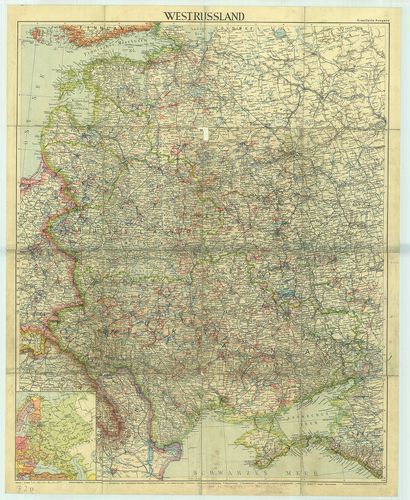
| Title | Westrussland. |
| Main title | 1 mt.: Európai Oroszország.Nyugat-Oroszország térképe. |
4908. Etnographisch-geographische Karte des Nördlichen Ural Gebiet... [B XI c 268]
Institute and Museum of Military History •
B XI c
•
B XI Oroszország
•
B I–XV. Európa
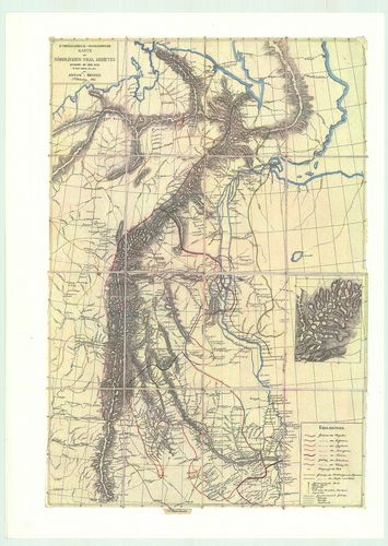
| Title | Etnographisch-geographische Karte des Nördlichen Ural Gebietes |
| Main title | Az Észak-Ural néprajzi és földrajzi térképe. |
4909. [Odessa, (Odessza) térségének hajózási és vasútvonalai.] [B XI c 270]
Institute and Museum of Military History •
B XI c
•
B XI Oroszország
•
B I–XV. Európa
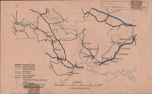
| Title | [Odessa, (Odessza) térségének hajózási és vasútvonalai.] |
4910. Eisenbahnkarte v.[on] Russland u.[nd] Ukraine. Aufgelegt im ... [B XI c 271]
Institute and Museum of Military History •
B XI c
•
B XI Oroszország
•
B I–XV. Európa
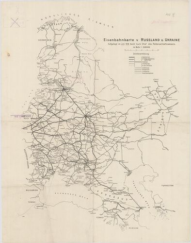
| Title | Eisenbahnkarte v.[on] Russland u.[nd] Ukraine. Aufgelegt im Juli 1918. beim K. u. k. Chef des Feldeisenbahnwesens. |
| Main title | Oroszország és Ukrajna vasúti térképe, Norvégia-Perzsia (Irán) Keleti-tenger–Ural-hegység közötti térségben. |
4911. Karta Bachmutszkago uezda, Jekaterinoszalvszkoj gubernii. Sz... [B XI c 272]
Institute and Museum of Military History •
B XI c
•
B XI Oroszország
•
B I–XV. Európa
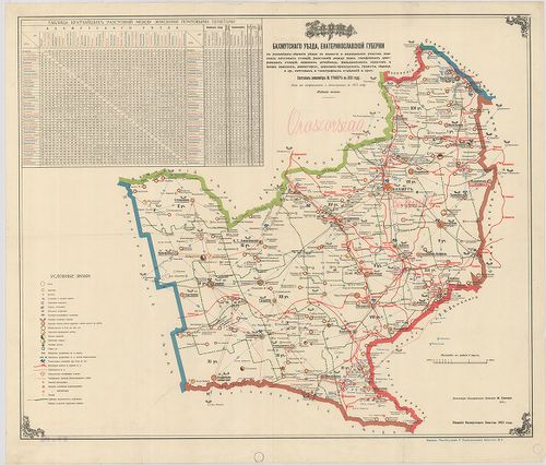
| Title | Karta Bachmutszkago uezda, Jekaterinoszalvszkoj gubernii. Szoszt.: –, 1891. Iszpravl. i dopoln. v. 1915. godu. Izd. 5. |
| Main title | A Bachmuti járás térképe Jekaterinoszlav kormányzóságban. Közigazgatási, iskolai, egyházi, egészségügyi, posta és távirodai, vasúti hálózat. Távolságok jegyz. |
4912. Russich–Ponisches Industriegebiet. [B XI c 273]
Institute and Museum of Military History •
B XI c
•
B XI Oroszország
•
B I–XV. Európa
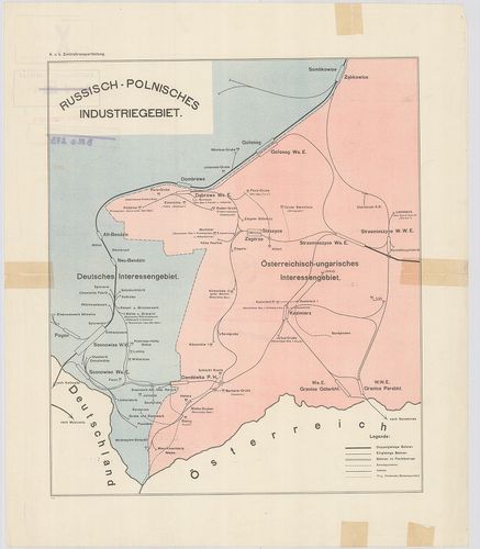
| Title | Russich–Ponisches Industriegebiet. |
| Main title | Az orosz–lengyel iparvidék vázlatos térképe. |
4913. Die Ausgestaltung des russischen Eisenbahnnetzes Während des... [B XI c 274]
Institute and Museum of Military History •
B XI c
•
B XI Oroszország
•
B I–XV. Európa
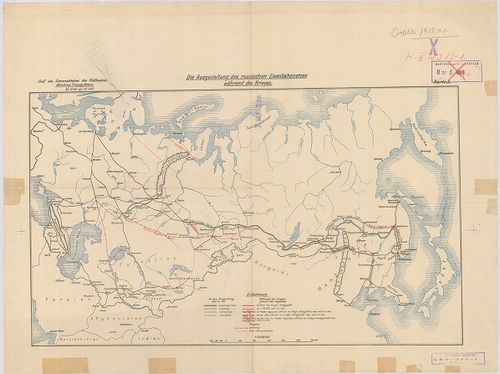
| Title | Die Ausgestaltung des russischen Eisenbahnnetzes Während des Krieges Karte 3. |
| Main title | Az orosz vasúthálózat térképe az első világháború idején. |
4914. Das Radiotelegraphennetz Russlands Ende 1911. Beilage 10. [B XI c 275]
Institute and Museum of Military History •
B XI c
•
B XI Oroszország
•
B I–XV. Európa
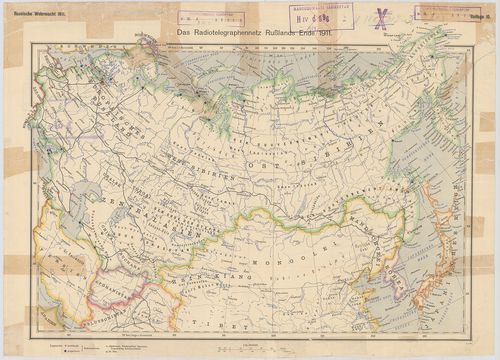
| Title | Das Radiotelegraphennetz Russlands Ende 1911. Beilage 10. |
| Main title | Oroszország rádiótelefon-hálózata 1911 végén. |
4915. Südwestrussland. Flemmings Kriegskarte Nr. 41. [B XI c 276]
Institute and Museum of Military History •
B XI c
•
B XI Oroszország
•
B I–XV. Európa
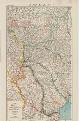
| Title | Südwestrussland. Flemmings Kriegskarte Nr. 41. |
| Main title | Oroszország DNy-i része |
4916. Westliches Russland mit den deutschen, österreichisch–ungari... [B XI c 277]
Institute and Museum of Military History •
B XI c
•
B XI Oroszország
•
B I–XV. Európa
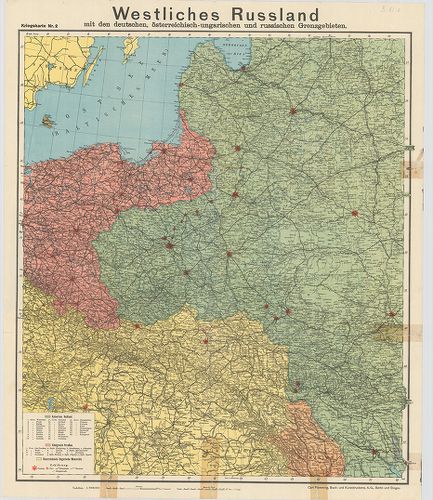
| Title | Westliches Russland mit den deutschen, österreichisch–ungarischen und russischen Grenzgebieten. Kriegskarte Nr. 2. |
| Main title | Oroszország Ny-i része az osztrák–magyar, német és orosz határvidék térképe. |
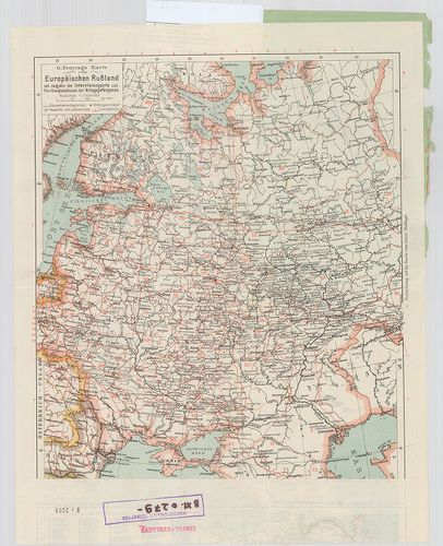
4917. G. Freytags Karte von Sibirien. Mit Angabe der Krigsgefangen... [B XI c 278]
Institute and Museum of Military History •
B XI c
•
B XI Oroszország
•
B I–XV. Európa
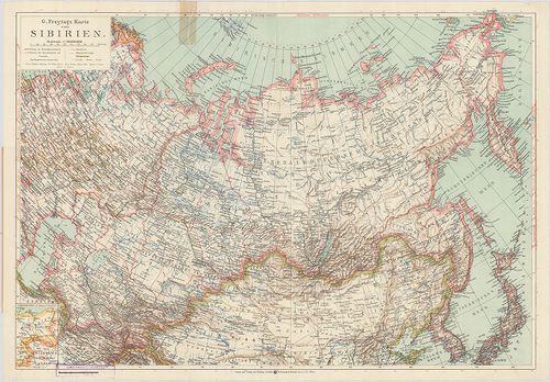
| Title | G. Freytags Karte von Sibirien. Mit Angabe der Krigsgefangenenlager. |
| Main title | Mt.: (Összehasonlító térképrészlet.) |
| Subject | A borítólap belső oldalán a hadifogolytáborok helynévmutatója, 1915. ápr. 20. helyzet. |
4918. Két térképlap: I. G. Freytags Karte vom Asiatischen Russland... [B XI c 279]
Institute and Museum of Military History •
B XI c
•
B XI Oroszország
•
B I–XV. Európa
| Title | Két térképlap: I. G. Freytags Karte vom Asiatischen Russland … |
| Main title | II. G. Freytags Karte vom Europäischen Russland. … |
| Subject | Mt.: (Összehasonlító térképrészlet.) |
4919. Die im Friedensvertrag von Brest-Litovsk Festgesetzte deutsc... [B XI c 280]
Institute and Museum of Military History •
B XI c
•
B XI Oroszország
•
B I–XV. Európa
| Title | Die im Friedensvertrag von Brest-Litovsk Festgesetzte deutsch–russische Grenze. |
| Main title | 1. Abo (Turku). 2. Helsingfors (Helsinki). 3. Königsberg (Kalinyingrad). 4. Wilna (Vilnius). 5. Warschau (Varsó). 6. Pinszk. |
| Subject | A brest–litovski békeszerződésben megállapított német–orosz határvidékének áttekintő térképe. Az új határ felülnyomásával Finnországtól–Galíciáig. |
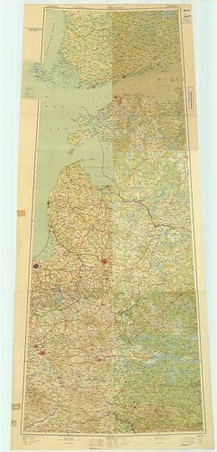
4920. Ravensteins Kriegskarte vom Gouvernement Kurland, Kowno, Wil... [B XI c 281]
Institute and Museum of Military History •
B XI c
•
B XI Oroszország
•
B I–XV. Európa
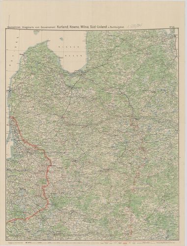
| Title | Ravensteins Kriegskarte vom Gouvernement Kurland, Kowno, Wilna, Süd-Livland u. Nachbargebiet. No. 30. |
| Main title | Az ÉK-Oroszország-i hadszíntér áttekintő térképe. Kurland (Kurzeme), Kowno (Kaunas), Wilna (Vilnius), Süd-Livland (Vidzeme). |