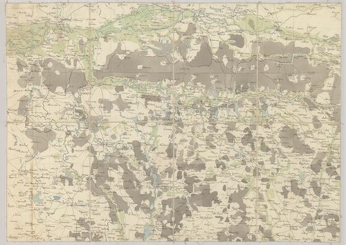
141. Ducatus Luneburgensis et Comitatus Dannebergensis nova tabul... [B IV a 203]
Institute and Museum of Military History •
B IV a
•
B IV Német birodalom
•
B I–XV. Európa
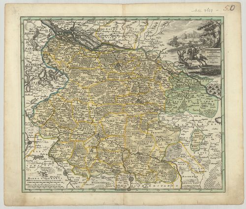
| Title | Ducatus Luneburgensis et Comitatus Dannebergensis nova tabula. |
| Main title | A Lüneburg-i hercegség és a Dannenberg-i grófság térképe. |
142. Le comté de la Marck, Les Seigneuries des Abbayes de Werden,... [B IV a 204]
Institute and Museum of Military History •
B IV a
•
B IV Német birodalom
•
B I–XV. Európa
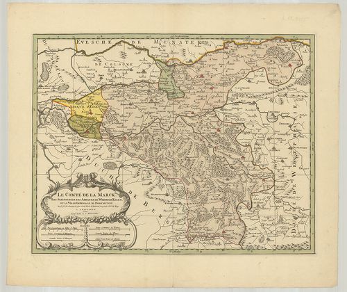
| Title | Le comté de la Marck, Les Seigneuries des Abbayes de Werden, d’Essen, et la Ville Imperiale de Dortmund. |
| Main title | Németország: Mark grófság, Werden, Essen grófság és apátságok és Dortmund császári város térképe. |
143. Potentissimo Borussorum Regi Friderico Wilhelmo Majestate, F... [B IV a 205]
Institute and Museum of Military History •
B IV a
•
B IV Német birodalom
•
B I–XV. Európa
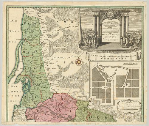
| Title | Potentissimo Borussorum Regi Friderico Wilhelmo Majestate, Fortitudine Clementia Augustissimo Hancce Lithuaniam Borussicam in qua loca colonijs Salisburg. |
| Main title | Mt.: Plan von der in Litthauen neu angelegten Stadt Gumbinnen. (Guszev város térképe.)Porosz-Litvánia térképe 1733-ban. |
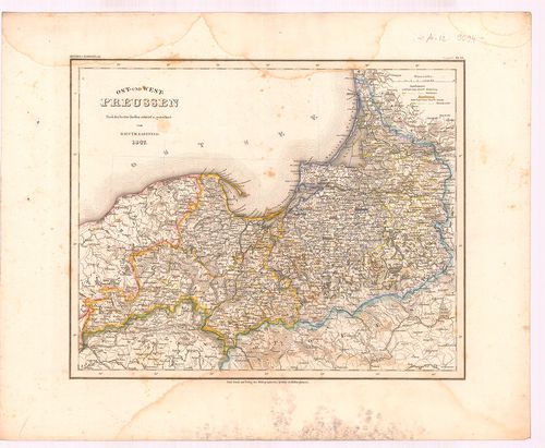
144. General Karte von Ost-West-Süd und Neu-Ostpreussen. [B IV a 210]
Institute and Museum of Military History •
B IV a
•
B IV Német birodalom
•
B I–XV. Európa
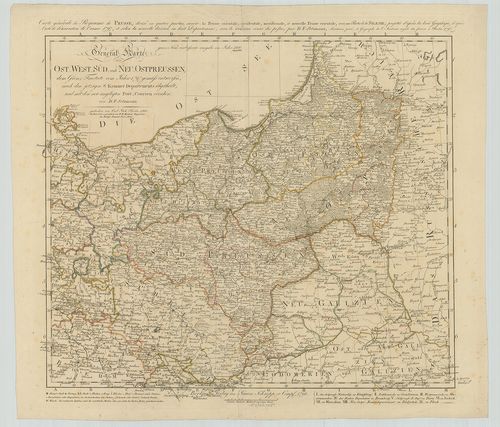
| Title | General Karte von Ost-West-Süd und Neu-Ostpreussen. |
| Main title | A Porosz Királyság általános térképe 1796-ban. |
145. [Dél-Poroszország általános térképe.] [B IV a 211]
Institute and Museum of Military History •
B IV a
•
B IV Német birodalom
•
B I–XV. Európa
| Title | [Dél-Poroszország általános térképe.] |
146. Karte von Ost-Preussen, Litthauen, West-Preussen und dem Net... [B IV a 212]
Institute and Museum of Military History •
B IV a
•
B IV Német birodalom
•
B I–XV. Európa

| Title | Karte von Ost-Preussen, Litthauen, West-Preussen und dem Netz-Distrikte, enthaltend die Regierungs-Bezirke: Koenigsberg, Gumbinnen, Danzig, Marienwerder und Bromberg. |
| Main title | Poroszország, Litvánia általános térképe 1848-ban. |
147. Kétold. térk. I. Deutschland. [B IV a 213]
Institute and Museum of Military History •
B IV a
•
B IV Német birodalom
•
B I–XV. Európa
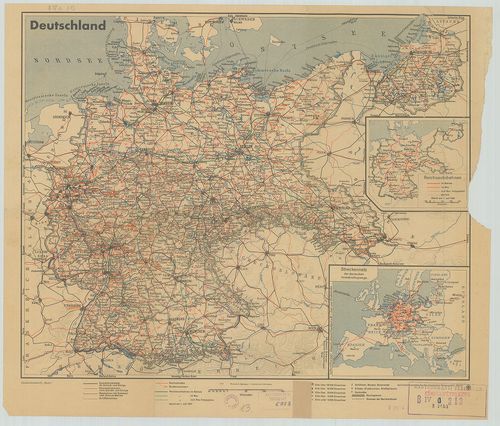
| Title | Kétold. térk. I. Deutschland. |
| Main title | 2 mt.: 1. Reichsautobahnen. (Az ország autótérképe.) 2. Streckennetz der deutschen Verkehrsflugzeuge. (Légiúthálózat.)Németország út-vasúttérképe 1937-ben. |
| Subject | II. Kurmark Brandenburg |
148. Preussische Provinz Sachsen. [B IV a 214]
Institute and Museum of Military History •
B IV a
•
B IV Német birodalom
•
B I–XV. Európa
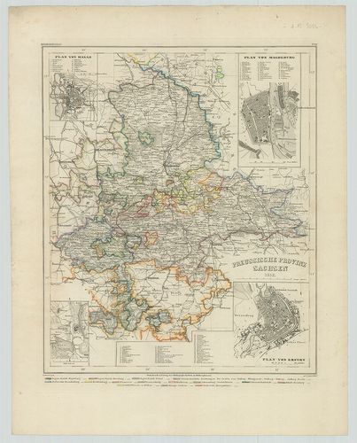
| Title | Preussische Provinz Sachsen. |
| Main title | 4 mt.: 1. Plan von Halle. 2. Plan von Magdeburg. 3. Torgau. 4. Plan von Erfurt. |
| Subject | A szász tartományok általános térképe 1852-ben. |
149. Provinz Ostpreussen. [B IV a 215]
Institute and Museum of Military History •
B IV a
•
B IV Német birodalom
•
B I–XV. Európa
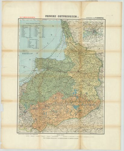
| Title | Provinz Ostpreussen. |
| Main title | Mt.: [Königsberg (Kalinyingrád) és környéke.] |
| Subject | Kelet-Poroszország tartományainak térképe. |
150. Charte vom Königreich Preussen, nach seiner dermaligen Einth... [B IV a 215/1]
Institute and Museum of Military History •
B IV a
•
B IV Német birodalom
•
B I–XV. Európa
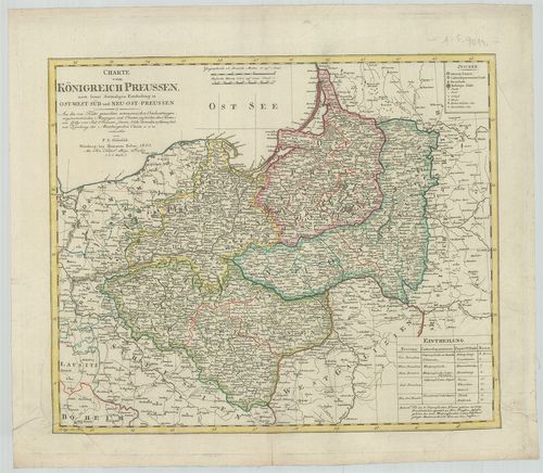
| Title | Charte vom Königreich Preussen, nach seiner dermaligen Eintheilung in Ost-West-Süd und Neu-Ost-Preussen. |
| Main title | A Porosz Királyság térképe 1805-ben. |
151. Kétold. térk. I. Ostpreussen und Litauen. II. Kurland und Li... [B IV a 216]
Institute and Museum of Military History •
B IV a
•
B IV Német birodalom
•
B I–XV. Európa
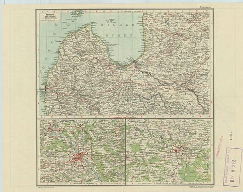
| Title | Kétold. térk. I. Ostpreussen und Litauen. II. Kurland und Livland. |
| Main title | 2 mt.: Warschau und Umgebung. (Varsó és környéke.) 2. Brest-Litowsk und Umgebung. (Breszt és környéke.) |
| Subject | I. Kelet-Poroszország és Litvánia. II. Kurföld és Livonija térképe. |
152. Tabula Geographica Totam Borussiam ut et Districtum Notecens... [B IV a 216/1]
Institute and Museum of Military History •
B IV a
•
B IV Német birodalom
•
B I–XV. Európa
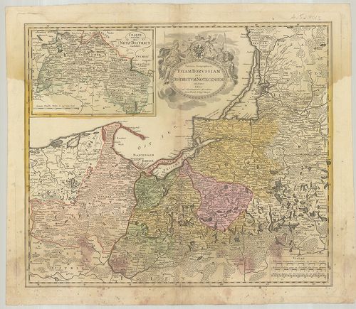
| Title | Tabula Geographica Totam Borussiam ut et Districtum Notecensem. |
| Main title | Mt.: Charte welche den Netz District vorstellet. (Kujawy terület térképe.)Poroszország térképe kerületi beosztással. |
153. Karte von den Königl. Preussischen Provinzen Preussen und Po... [B IV a 217]
Institute and Museum of Military History •
B IV a
•
B IV Német birodalom
•
B I–XV. Európa
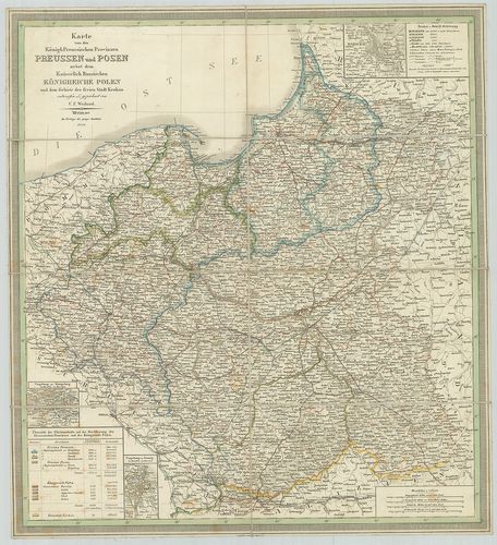
| Title | Karte von den Königl. Preussischen Provinzen Preussen und Posen nebst dem Kaiserlich Russischen Königreiche Polen. |
| Main title | 3 mt.: Umgebung von Königsberg. (Kalinyingrád és környéke.) 2. Umgebung von Danzig. (Gdansk és környéke.) 3. Umgebung von Warschau. (Varsó és környéke.)A Porosz Királyság tartományai és Lengyelország térképe 1847-ben. |
154. Ost- und West-Preussen. [B IV a 218]
Institute and Museum of Military History •
B IV a
•
B IV Német birodalom
•
B I–XV. Európa
| Title | Ost- und West-Preussen. |
| Main title | Kelet-és Nyugat-Poroszország térképe 1847-ben. |
155. Provinz Brandenburg. [B IV a 219]
Institute and Museum of Military History •
B IV a
•
B IV Német birodalom
•
B I–XV. Európa
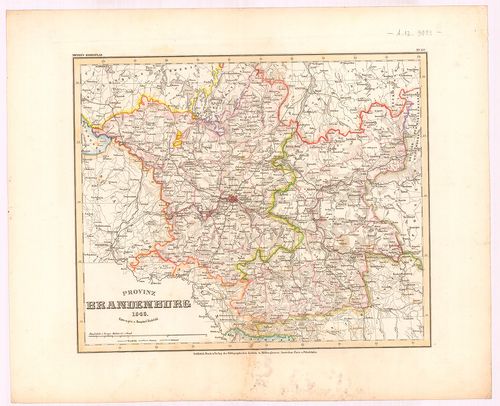
| Title | Provinz Brandenburg. |
| Main title | Brandenburg tartomány térképe 1846-ban. |
156. Provinz Posen. [B IV a 220]
Institute and Museum of Military History •
B IV a
•
B IV Német birodalom
•
B I–XV. Európa
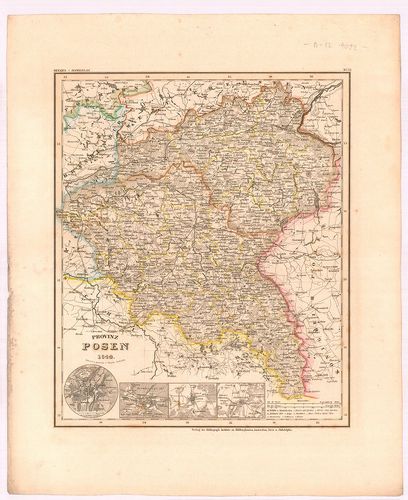
| Title | Provinz Posen. |
| Main title | 4 mt.: 1. Posen (Poznan) 2. Bromberg, (Bydgoszcz) 3. Lissa, (Leszno) 4. Fraustadt, (Wschowa) Várostérk. |
| Subject | Posen tartomány térképe 1844-ben. |
157. Provinz Pommern. [B IV a 221]
Institute and Museum of Military History •
B IV a
•
B IV Német birodalom
•
B I–XV. Európa
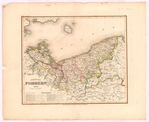
| Title | Provinz Pommern. |
| Main title | Pomerániai tartomány térképe 1845-ben. |
158. [A Pomeránia-i hercegség térképe.] [B IV a 225]
Institute and Museum of Military History •
B IV a
•
B IV Német birodalom
•
B I–XV. Európa
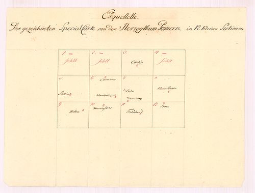
| Title | [A Pomeránia-i hercegség térképe.] |
159. Special Karte des Deutschen Reiches. [B IV a 226]
Institute and Museum of Military History •
B IV a
•
B IV Német birodalom
•
B I–XV. Európa
| Title | Special Karte des Deutschen Reiches. |
| Main title | 5 mt.: 1. Hamburg u. Umgebung. (Hamburg és környéke.) 2. München u. Umgebung. (München és környéke.) 3. Industrie-Bezirk zwischen Rhein, Ruhr u. Wupper. (A Ruhr-vidék.) 4. Dresden u. Umgebung. (Drezda és környéke.) 5. Berlin u. Umgebung (Berlin és környéke.)Németország keleti részének térképe. |
160. Charte vom Königreiche Preussen dem Herzogthum Warschau und ... [B IV a 232]
Institute and Museum of Military History •
B IV a
•
B IV Német birodalom
•
B I–XV. Európa
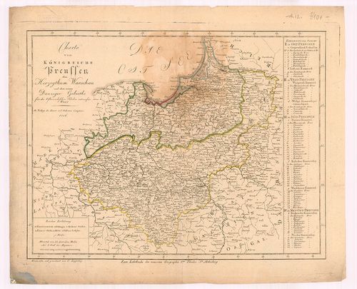
| Title | Charte vom Königreiche Preussen dem Herzogthum Warschau und dem neuen Danziger Gebiethe für die Österreichischen Schulen. |
| Main title | A Porosz Királyság, a Varsói hercegség és Gdansk térképe 1806-ban. |