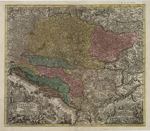
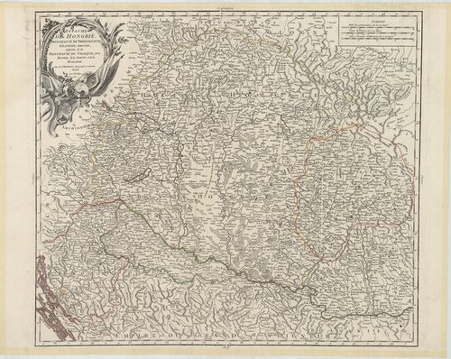
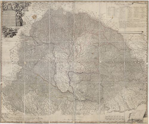
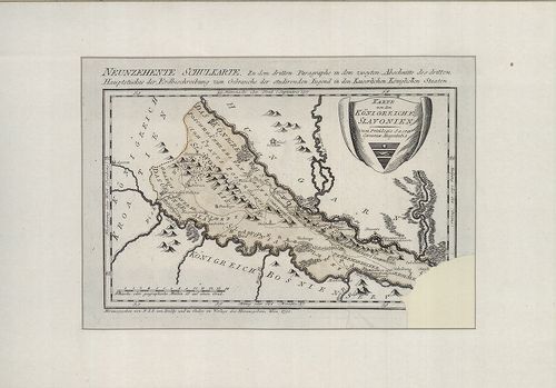
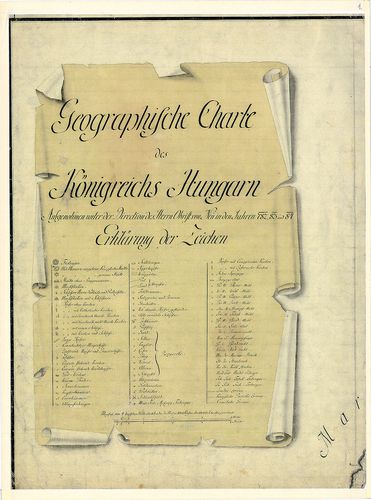
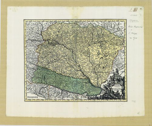
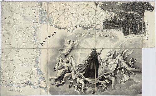
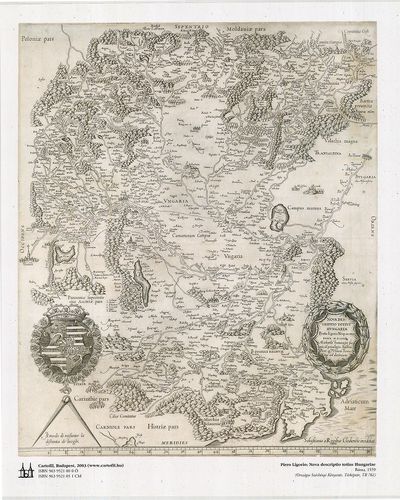
601. Ungarn. In dieser Charten seyn zu seben die angränzende Länd... [B IX a 1031]
Institute and Museum of Military History •
B IX a
•
B IX Ausztria–Magyarország
•
B I–XV. Európa
| Title | Ungarn. In dieser Charten seyn zu seben die angränzende Ländern als Croatien, Dalmatien, Sclavonien. Siebenbürgen, Moldau, Wallacheu Bulgarien, Romanien, bis an das schwarze Meer u. Constantinopel. |
| Main title | Magyarország, Erdély és a Balkán-félsziget államainak térképe a 18. század elején. |
602. Das Reich der Ungern von 907. bis 1007. [B IX a 1032]
Institute and Museum of Military History •
B IX a
•
B IX Ausztria–Magyarország
•
B I–XV. Európa
| Title | Das Reich der Ungern von 907. bis 1007. |
| Main title | Magyarország történelmi térképe a 10. század fordulóján. |
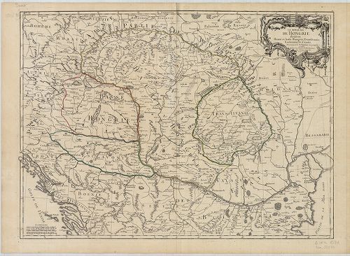
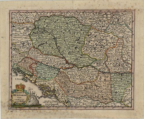
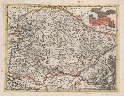
603. Nova et accurata Tabula sedis belli in Regno Hungariae. Acce... [B IX a 1039]
Institute and Museum of Military History •
B IX a
•
B IX Ausztria–Magyarország
•
B I–XV. Európa
| Title | Nova et accurata Tabula sedis belli in Regno Hungariae. Accendunt cetera Regna Sclavonia, Croatia, Bosnia, Servia, Dalmatia, Bulgaria et Romania… |
| Main title | A Magyar Királyság , Horvát-Szlavónia, Bosznia, Szerbia, Dalmácia, Bulgária, Moldva, Erdély, Havasalföld térképe 1717-ben. |
604. Magyar Ország távcső földképe. II. Osztály. Pozsony vármegye... [B IX a 1068]
Institute and Museum of Military History •
B IX a
•
B IX Ausztria–Magyarország
•
B I–XV. Európa
| Title | Magyar Ország távcső földképe. II. Osztály. Pozsony vármegye. Sz. György és Stomfa vidékjökkel. |
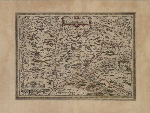
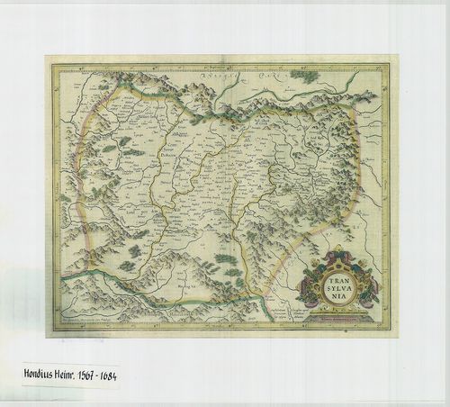
605. Transylvaniae Principatus in quimque Nations divisus... [B IX a 1069]
Institute and Museum of Military History •
B IX a
•
B IX Ausztria–Magyarország
•
B I–XV. Európa
| Title | Transylvaniae Principatus in quimque Nations divisus... |
| Main title | Az Erdélyi Nagyfejedelemség térképe. |
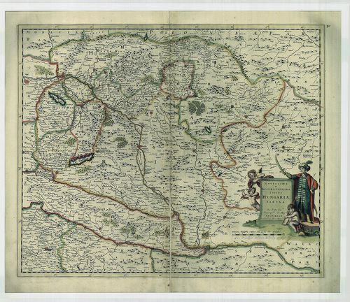
606. Novisima et accuratisima Hungariae cum circumjacentibus Regn... [B IX a 1071]
Institute and Museum of Military History •
B IX a
•
B IX Ausztria–Magyarország
•
B I–XV. Európa
| Title | Novisima et accuratisima Hungariae cum circumjacentibus Regnis et Principatibus … |
| Main title | Magyarország és a környező államok térképe. |
607. Ungarisches Kriegs-Theatrum in Servien und dem Bannat Temesw... [B IX a 1072]
Institute and Museum of Military History •
B IX a
•
B IX Ausztria–Magyarország
•
B I–XV. Európa
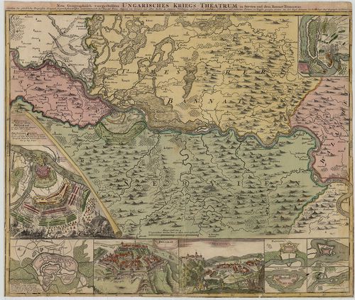
| Title | Ungarisches Kriegs-Theatrum in Servien und dem Bannat Temeswar... |
| Main title | Alsó-Magyarország hadszíntértérképe a karlócai béke (1699) határvonalával, városok alaprajzával és a péterváradi csata és Belgrád ostromának képével, az osztrák–török háború 1716–17-es szerbiai és a bánáti hadszíntér. |
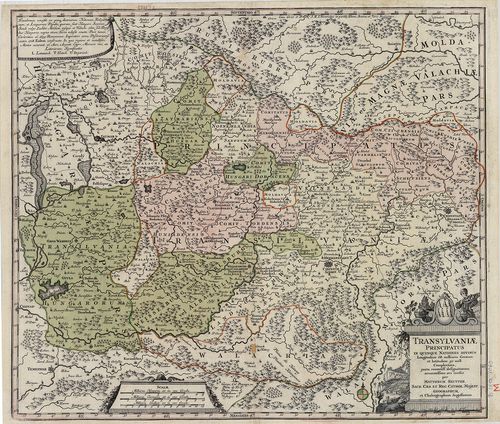
608. Transilvania… [B IX a 1073]
Institute and Museum of Military History •
B IX a
•
B IX Ausztria–Magyarország
•
B I–XV. Európa
| Title | Transilvania… |
| Main title | Erdély térképe, hátoldalán latin nyelvű magyarázó szöveg és magyar, német és latin helységnévtár. |
609. Österreichisch–Ungarische Monarchie. No. 22. [B IX a 1074]
Institute and Museum of Military History •
B IX a
•
B IX Ausztria–Magyarország
•
B I–XV. Európa

| Title | Österreichisch–Ungarische Monarchie. No. 22. |
| Main title | Mt.: Umgegend von Wien. |
| Subject | Az Osztrák–Magyar Monarchia térképe 1880 körül. |
610. Regnum Hungaria in Omnes suos Comitatus Accurate... [B IX a 1075]
Institute and Museum of Military History •
B IX a
•
B IX Ausztria–Magyarország
•
B I–XV. Európa
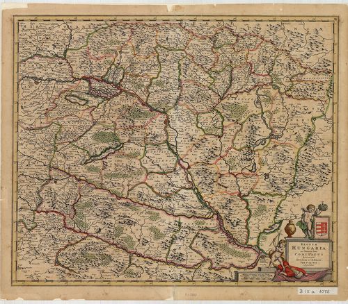
| Title | Regnum Hungaria in Omnes suos Comitatus Accurate... |
| Main title | A Magyar Királyság térképe a XVII. sz. végén, megyebeosztással. |
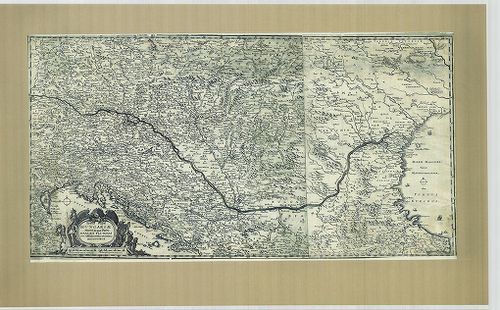
611. Partie Septentrionale Du Roy(ou)me De Hongrie tirée de diver... [B IX a 1076]
Institute and Museum of Military History •
B IX a
•
B IX Ausztria–Magyarország
•
B I–XV. Európa
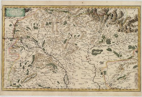
| Title | Partie Septentrionale Du Roy(ou)me De Hongrie tirée de divers Autherus. |
| Main title | A Magyar Királyság északi része a XVII. sz. második felében. |
612. [Vágújhely.] Vagh-Uiheller Process. [B IX a 1077]
Institute and Museum of Military History •
B IX a
•
B IX Ausztria–Magyarország
•
B I–XV. Európa
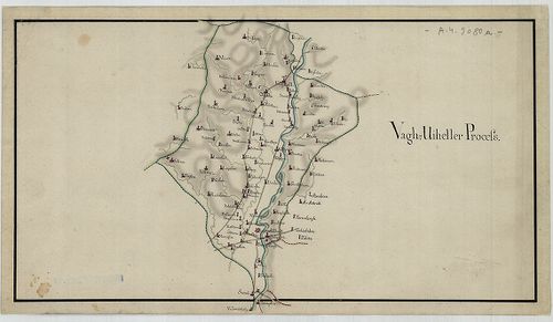
| Title | [Vágújhely.] Vagh-Uiheller Process. |
613. Hungaria. [B IX a 1079]
Institute and Museum of Military History •
B IX a
•
B IX Ausztria–Magyarország
•
B I–XV. Európa
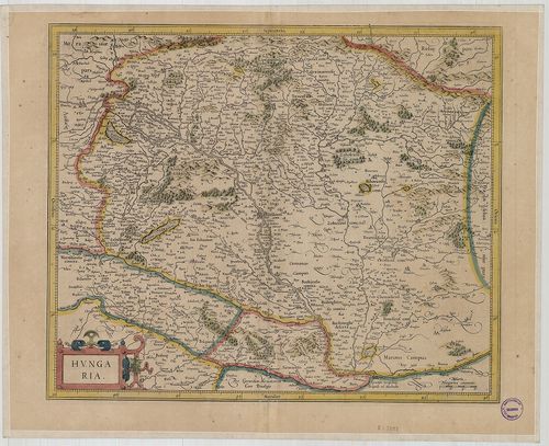
| Title | Hungaria. |
| Main title | Magyarország térképe. |
614. A new map of Hungary, with its divisions into geschpanchafts... [B IX a 1080]
Institute and Museum of Military History •
B IX a
•
B IX Ausztria–Magyarország
•
B I–XV. Európa
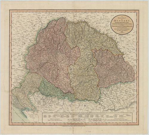
| Title | A new map of Hungary, with its divisions into geschpanchafts or counties; the Principality of Transilvania, Croatia … |
| Main title | Magyarország térképe a XVIII. sz. végén. |
615. Nouvelle Carte de la Hongrie … [B IX a 1081]
Institute and Museum of Military History •
B IX a
•
B IX Ausztria–Magyarország
•
B I–XV. Európa
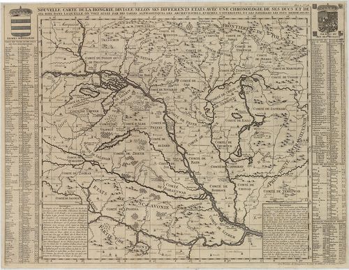
| Title | Nouvelle Carte de la Hongrie … |
| Main title | Magyarország XVII. század végi térképe, mellékletként a fontosabb ütközetek évszámai, a megyék és helységek névanyaga. |
616. La Transilvania Diuisa su L’Esemplare delle Carte … [B IX a 1082]
Institute and Museum of Military History •
B IX a
•
B IX Ausztria–Magyarország
•
B I–XV. Európa
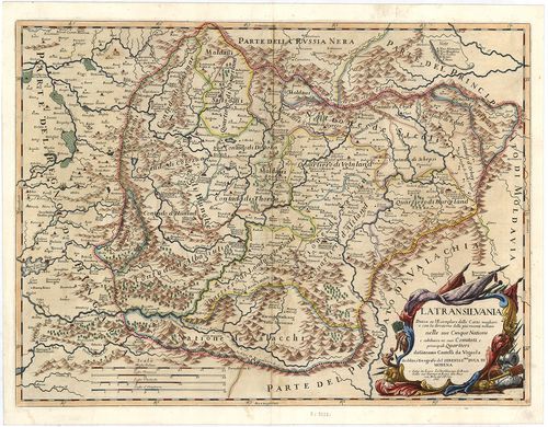
| Title | La Transilvania Diuisa su L’Esemplare delle Carte … |
| Main title | Erdély térképe 1686-ban, a nemzetiségi területek megnevezésével. |
617. Carte de la Hongrie a l’Autriche… [B IX a 1083]
Institute and Museum of Military History •
B IX a
•
B IX Ausztria–Magyarország
•
B I–XV. Európa
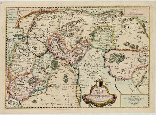
| Title | Carte de la Hongrie a l’Autriche… |
| Main title | Magyarország É-i részének térképe 1664-ben. |
618. A New Mapp of the Kingdom of Hungary and the Adjacent Countr... [B IX a 1084]
Institute and Museum of Military History •
B IX a
•
B IX Ausztria–Magyarország
•
B I–XV. Európa
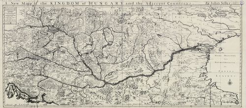
| Title | A New Mapp of the Kingdom of Hungary and the Adjacent Countreys. |
| Main title | A Magyar Királyság és a szomszédos országok térképe. |
619. (Ausztria, É-Itália, Svájc, Dalmácia, Magyarország területe.... [B IX a 1087]
Institute and Museum of Military History •
B IX a
•
B IX Ausztria–Magyarország
•
B I–XV. Európa
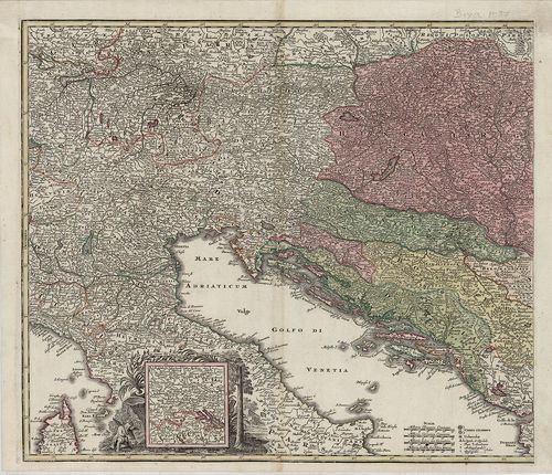
| Title | (Ausztria, É-Itália, Svájc, Dalmácia, Magyarország területe.) Cím nélküli, a cím helyén a Bádeni-tó és környékének térképkivágata. |
620. Royaume de Hongrie, Principaute de Transilvanie, Sclavonie, ... [B IX a 1088]
Institute and Museum of Military History •
B IX a
•
B IX Ausztria–Magyarország
•
B I–XV. Európa
| Title | Royaume de Hongrie, Principaute de Transilvanie, Sclavonie, Croatie et partie de la Principauté de Valaqie, de la Bosnie, de la Servie et de la Bulgarie. |
| Main title | A Magyar Királyság, Erdély, Horvát-Szlavónia, Havasalföld, Bosznia, Szerbia, Bulgária térképe. |
621. Principauté de Transilvanie Divisée en Cinq Nations Subdivis... [B IX a 1090]
Institute and Museum of Military History •
B IX a
•
B IX Ausztria–Magyarország
•
B I–XV. Európa
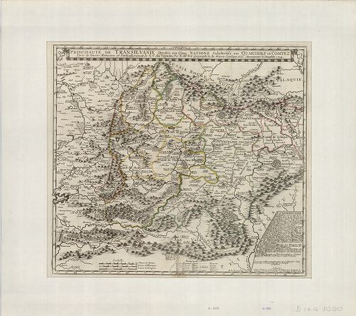
| Title | Principauté de Transilvanie Divisée en Cinq Nations Subdivisée en Quartiers et Comtez. |
| Main title | Az Erdélyi Nagyfejedelemség térképe közigazgatási beosztással. |
622. Le Royaume de Hongrie divisé en Haute et basse Hongrie, Tran... [B IX a 1091]
Institute and Museum of Military History •
B IX a
•
B IX Ausztria–Magyarország
•
B I–XV. Európa
| Title | Le Royaume de Hongrie divisé en Haute et basse Hongrie, Transilvanie, Esclavonie et Croatie. |
| Main title | Magyarország, Erdély, Horvát-Szlavónia térképe. |
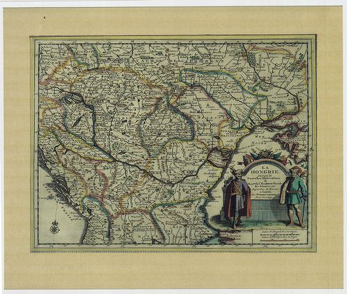
623. Le Royaume de Hongrie et les Estats qui ont este … [B IX a 1092]
Institute and Museum of Military History •
B IX a
•
B IX Ausztria–Magyarország
•
B I–XV. Európa
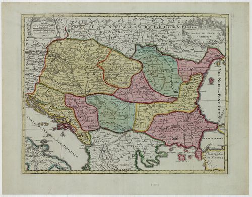
| Title | Le Royaume de Hongrie et les Estats qui ont este … |
| Main title | Magyarország és a Balkán-félsziget északi államainak térképe, határvonal színezéssel. |
624. Territorio di Naiasel, e Grau siu’ a Comora, Pescritto, e De... [B IX a 1093]
Institute and Museum of Military History •
B IX a
•
B IX Ausztria–Magyarország
•
B I–XV. Európa
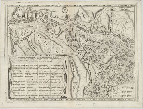
| Title | Territorio di Naiasel, e Grau siu’ a Comora, Pescritto, e Dedicatio dal P. Maestro Coronelli, Lettore, e Casmografico Publico. |
| Main title | Az Esztergom, Érsekújvár és Komárom közötti terület a visszafoglaló háborúban a párkányi csata és az érsekújvári ostromzár ábrázolásával. |
625. Transylvania. [B IX a 1095]
Institute and Museum of Military History •
B IX a
•
B IX Ausztria–Magyarország
•
B I–XV. Európa
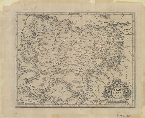
| Title | Transylvania. |
| Main title | Erdély térképe a XVII. sz. elején. |
626. Abbildung des Königreichs Ungarn durch Türckey biss nach Con... [B IX a 1099]
Institute and Museum of Military History •
B IX a
•
B IX Ausztria–Magyarország
•
B I–XV. Európa
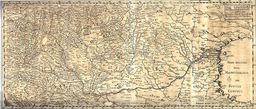
| Title | Abbildung des Königreichs Ungarn durch Türckey biss nach Constantinopel und zufinden bey Paulus Fürst Kunst und Buchändlern in Nürnberg. |
| Main title | A Magyar Királyság és a Török Birodalom (a Fekete-tengerig). |
627. Theatre de la Guerre d’Hongrie et Lieux Circonvoisins, selon... [B IX a 1100]
Institute and Museum of Military History •
B IX a
•
B IX Ausztria–Magyarország
•
B I–XV. Európa
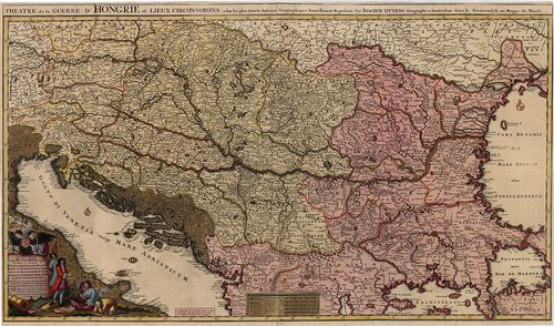
| Title | Theatre de la Guerre d’Hongrie et Lieux Circonvoisins, selon les plus Exacts Auteurs Geographiques Nouvellement Represente par Joachim Ottens. Novissima Tabula Regni Hungariae et Regio quondam ei unitarum ut Transilvaniae, Valachiae, Moldaviae, Serviae … |
| Main title | A Magyar Királyság és a környező országok. |
628. A New and Accurate Map of the Kingdom of Hungary and Princip... [B IX a 1101]
Institute and Museum of Military History •
B IX a
•
B IX Ausztria–Magyarország
•
B I–XV. Európa
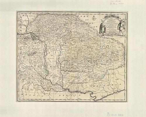
| Title | A New and Accurate Map of the Kingdom of Hungary and Principality of Transilvania with the bordering countries. In.: Bowen: A Complet Atlas or distinct wiew of the Know wWorld. London, 1752. |
| Main title | A Magyar Királyság, az Erdélyi Nagyfejedelemség és a környező országok térképe. |
629. Fines Hungariae Caroli VI. Caes. Aug. et Pace Pasarovicensi ... [B IX a 1103]
Institute and Museum of Military History •
B IX a
•
B IX Ausztria–Magyarország
•
B I–XV. Európa
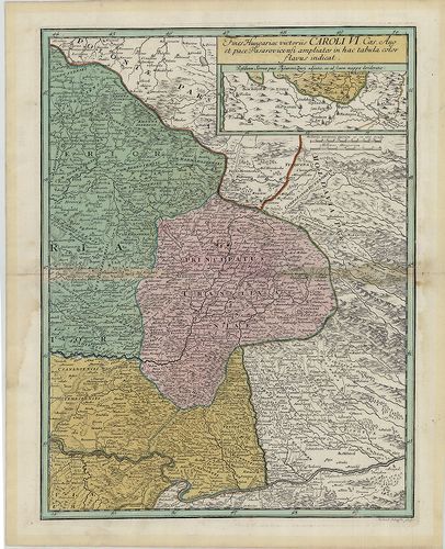
| Title | Fines Hungariae Caroli VI. Caes. Aug. et Pace Pasarovicensi ampliatos in hactabula Color Havus indicat. |
| Main title | A pozsareváci békekötéssel VI. Károly Habsburg uralkodó uralma alá került területek.(Magyarország keleti része, Erdély és a Temesi Bánság területe.) |
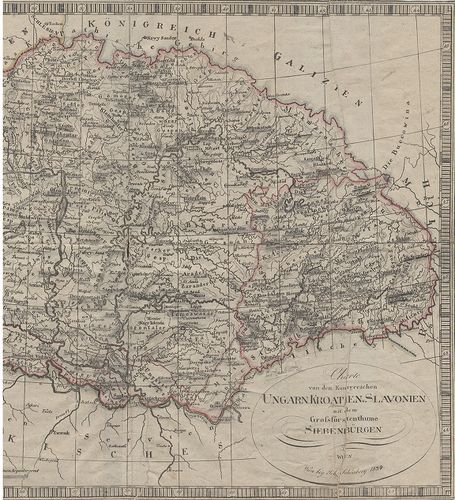
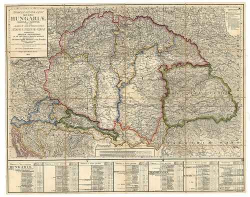
630. Mappa Novissima Regnorum Hungariae Croatiae, Slavoniae nec n... [B IX a 1105]
Institute and Museum of Military History •
B IX a
•
B IX Ausztria–Magyarország
•
B I–XV. Európa
| Title | Mappa Novissima Regnorum Hungariae Croatiae, Slavoniae nec non Magni Principatus Transilvaniae… – Novelle Carte du Royaume de Hongrie de Croatie de Slavonie et de Transylvanie… |
| Main title | A Magyar Királyság, Horvát-Szlavónia és Erdély térképe a 19. század elején. |
631. Karte von dem Königreiche Hungarn. [B IX a 1106]
Institute and Museum of Military History •
B IX a
•
B IX Ausztria–Magyarország
•
B I–XV. Európa
| Title | Karte von dem Königreiche Hungarn. |
| Main title | A Magyar Királyság térképe. Reilly által készített iskolai térképek 15. lapja. |
632. Karte von Niederhungarn … [B IX a 1107]
Institute and Museum of Military History •
B IX a
•
B IX Ausztria–Magyarország
•
B I–XV. Európa

| Title | Karte von Niederhungarn … |
| Main title | Alsó-Magyarország térképe. Reilly által készített iskolai térképek 16. lapja. |
633. Karte von Oberhungarn … [B IX a 1108]
Institute and Museum of Military History •
B IX a
•
B IX Ausztria–Magyarország
•
B I–XV. Európa
| Title | Karte von Oberhungarn … |
| Main title | Felső-Magyarország térképe. Reilly által készített iskolai térképek 17. lapja. |
634. Karte von Croatien … [B IX a 1109]
Institute and Museum of Military History •
B IX a
•
B IX Ausztria–Magyarország
•
B I–XV. Európa
| Title | Karte von Croatien … |
| Main title | Horvátország térképe. Reilly által készített iskolai térképek 18. lapja. |
635. Karte vn dem Königreiche Slavonie. [B IX a 1110]
Institute and Museum of Military History •
B IX a
•
B IX Ausztria–Magyarország
•
B I–XV. Európa
| Title | Karte vn dem Königreiche Slavonie. |
| Main title | A Szlavón Királyság térképe Reilly által készített iskolai térképek 19. lapja. |
636. Uibersichts-Karte der Erzherzoglichen Herrschaft Ungarisch A... [B IX a 1111]
Institute and Museum of Military History •
B IX a
•
B IX Ausztria–Magyarország
•
B I–XV. Európa
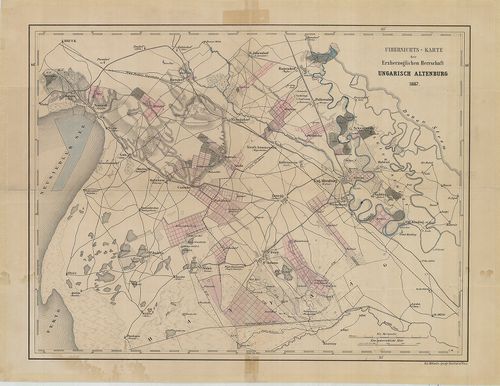
| Title | Uibersichts-Karte der Erzherzoglichen Herrschaft Ungarisch Altenburg. |
| Main title | Magyaróvár (Mosonmagyaróvár) és környékének térképe. |
637. [A Magyar királyság nyugati felének térképe.] [B IX a 1112]
Institute and Museum of Military History •
B IX a
•
B IX Ausztria–Magyarország
•
B I–XV. Európa
| Title | [A Magyar királyság nyugati felének térképe.] |
| Main title | Magyarország nyugati felének térképe, többnyelvű névírás, ostromok és csaták évszámai. |
638. Carte de la Hungrie, de la Transilvanie… [B IX a 1113]
Institute and Museum of Military History •
B IX a
•
B IX Ausztria–Magyarország
•
B I–XV. Európa
| Title | Carte de la Hungrie, de la Transilvanie… |
| Main title | Magyarország és Erdély térképe. |
639. Plan von einem Theil der Gegend beiden Papagej zwischen dem ... [B IX a 1114]
Institute and Museum of Military History •
B IX a
•
B IX Ausztria–Magyarország
•
B I–XV. Európa
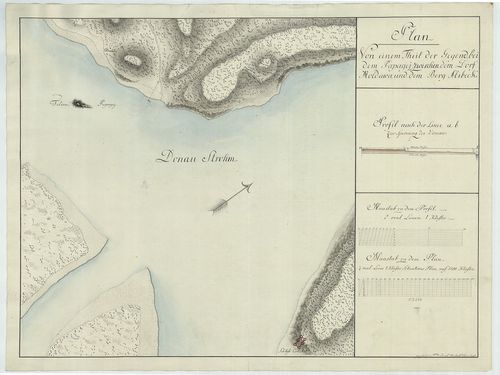
| Title | Plan von einem Theil der Gegend beiden Papagej zwischen dem Dorf Moldowa und dem Berg Alibeck. |
| Main title | A Papagáj-sziget (tört. Mo. déli határa) és környékének térképe. |
640. Plan vortheilhaften Truppen-Aufstellungen zwischen der Dunau... [B IX a 1117]
Institute and Museum of Military History •
B IX a
•
B IX Ausztria–Magyarország
•
B I–XV. Európa

| Title | Plan vortheilhaften Truppen-Aufstellungen zwischen der Dunau, der Raab und dem Blatten See. |
| Main title | A csapatok mozgása a Duna, Rába és a Balaton között. |
641. Übersichts-Karte von der südlichen u. grösseren Hälfte des T... [B IX a 1118]
Institute and Museum of Military History •
B IX a
•
B IX Ausztria–Magyarország
•
B I–XV. Európa
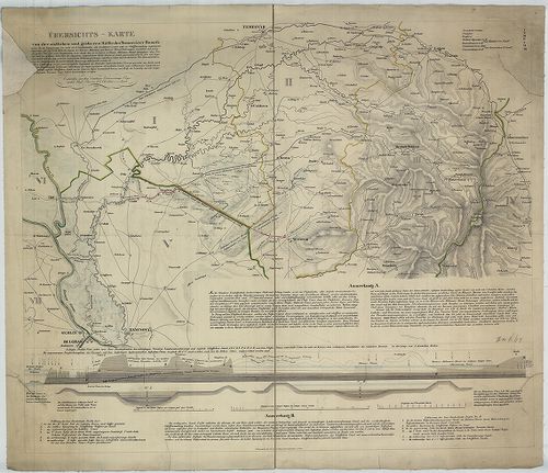
| Title | Übersichts-Karte von der südlichen u. grösseren Hälfte des Temesvarer Banat’s. |
| Main title | A Temesi Bánság déli részének térképe. |
642. General Karte des Grossfürstenthurms Siebenbürgen. [B IX a 1119]
Institute and Museum of Military History •
B IX a
•
B IX Ausztria–Magyarország
•
B I–XV. Európa
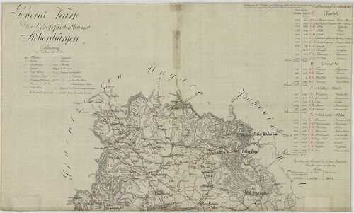
| Title | General Karte des Grossfürstenthurms Siebenbürgen. |
| Main title | Az Erdélyi Nagyhercegség általános térképe népességi adatokkal. |
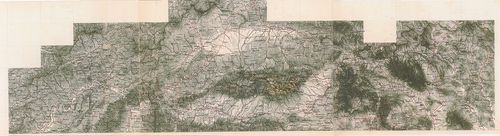
643. Geographische Charte des Königreichs Hungaria [B IX a 1120]
Institute and Museum of Military History •
B IX a
•
B IX Ausztria–Magyarország
•
B I–XV. Európa
| Title | Geographische Charte des Königreichs Hungaria |
| Main title | Magyarország földrajzi (általános) térképe az I. katonai felmérés alapján. |
644. Theatre de la Guerre ouvert en Hongrie dans la tartarie crim... [B IX a 1122]
Institute and Museum of Military History •
B IX a
•
B IX Ausztria–Magyarország
•
B I–XV. Európa
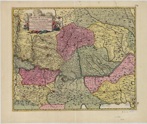
| Title | Theatre de la Guerre ouvert en Hongrie dans la tartarie crimée... |
| Main title | A Duna medencéje Pesttől a Fekete-tengerig. |
645. Magyar Ország és Erdély földabrosza. [B IX a 1125]
Institute and Museum of Military History •
B IX a
•
B IX Ausztria–Magyarország
•
B I–XV. Európa
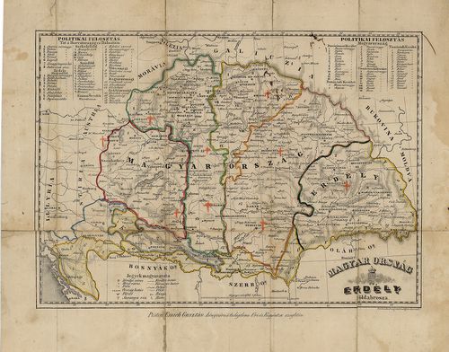
| Title | Magyar Ország és Erdély földabrosza. |
| Main title | Tartományi és megyehatárok. |
646. Carte des Broder Gräntz Regiments. [B IX a 1126]
Institute and Museum of Military History •
B IX a
•
B IX Ausztria–Magyarország
•
B I–XV. Európa
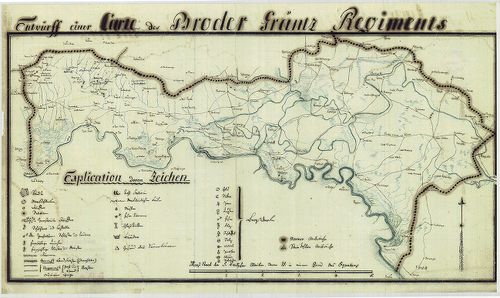
| Title | Carte des Broder Gräntz Regiments. |
| Main title | A Brodi határőrezred területének térképe a XIX. sz. elejéről. |
647. Carte des Gradiscaner Gräntz Regiments. [B IX a 1127]
Institute and Museum of Military History •
B IX a
•
B IX Ausztria–Magyarország
•
B I–XV. Európa
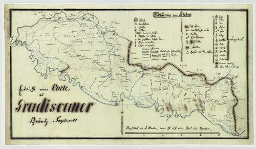
| Title | Carte des Gradiscaner Gräntz Regiments. |
| Main title | A Gradiscai határőrezred területének térképe a XIX. sz. elejéről. |
648. Carte des Warasdiner Gräntz Regiments. [B IX a 1128]
Institute and Museum of Military History •
B IX a
•
B IX Ausztria–Magyarország
•
B I–XV. Európa
| Title | Carte des Warasdiner Gräntz Regiments. |
| Main title | A Varasdi határőrezred területének térképe a XIX. sz. elejéről. |
649. Carte des Peterwardeiner Gränz Regiments. [B IX a 1129]
Institute and Museum of Military History •
B IX a
•
B IX Ausztria–Magyarország
•
B I–XV. Európa
| Title | Carte des Peterwardeiner Gränz Regiments. |
| Main title | A Péterváradi határőrezred területének térképe a XIX. sz. elejéről. |
650. Carte des ersten Banal Regiments. [B IX a 1130]
Institute and Museum of Military History •
B IX a
•
B IX Ausztria–Magyarország
•
B I–XV. Európa
| Title | Carte des ersten Banal Regiments. |
| Main title | Az Első Bánáti Regiment (Báni határőrezred) területének térképe a XIX. sz. elején. |
651. Eigentlicher Entwurff des zwischen Ungarn und Schlesien gele... [B IX a 1131]
Institute and Museum of Military History •
B IX a
•
B IX Ausztria–Magyarország
•
B I–XV. Európa
| Title | Eigentlicher Entwurff des zwischen Ungarn und Schlesien gelegene Iablonkover Passes... |
| Main title | A Jablunkai-hágó térképe a magyar-sziléziai határon. |
652. Royaume de Hongrie; Avec la Partie la plus Septentrionale de... [B IX a 1133]
Institute and Museum of Military History •
B IX a
•
B IX Ausztria–Magyarország
•
B I–XV. Európa
| Title | Royaume de Hongrie; Avec la Partie la plus Septentrionale de la Turquie D'Europe. |
| Main title | A Magyar Királyság; a Török Birodalom északi része Európában. |
653. La Hongrie. [B IX a 1135]
Institute and Museum of Military History •
B IX a
•
B IX Ausztria–Magyarország
•
B I–XV. Európa
| Title | La Hongrie. |
| Main title | Magyarország 1713-ból. |
654. Totius Regni Hungariae Maximaeque Partis Danubii Fluminis un... [B IX a 1137]
Institute and Museum of Military History •
B IX a
•
B IX Ausztria–Magyarország
•
B I–XV. Európa
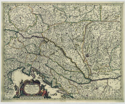
| Title | Totius Regni Hungariae Maximaeque Partis Danubii Fluminis una cum adjacentibus et finitimis Regionibus. |
| Main title | A Magyar Királyság térképe a környező Duna menti részekkel. |
655. Totius Regni Hungariae Maximae que Partis Danubii Fluminis ... [B IX a 1138]
Institute and Museum of Military History •
B IX a
•
B IX Ausztria–Magyarország
•
B I–XV. Európa
| Title | Totius Regni Hungariae Maximae que Partis Danubii Fluminis una cum adjacentibus et finitimis Regionibus. |
| Main title | A Magyar Királyság térképe a környező Duna menti részekkel. |
656. Hungaria, (Hongheren), Transylvania. [B IX a 1139]
Institute and Museum of Military History •
B IX a
•
B IX Ausztria–Magyarország
•
B I–XV. Európa
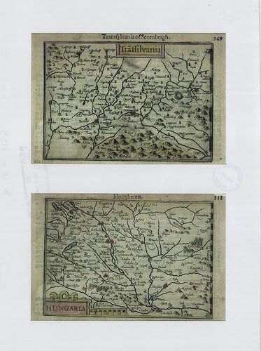
| Title | Hungaria, (Hongheren), Transylvania. |
| Main title | A Magyar Királyság és Erdély térképe. |
657. [Ungariae et omnium partium eius universalis descriptio.] [B IX a 1140]
Institute and Museum of Military History •
B IX a
•
B IX Ausztria–Magyarország
•
B I–XV. Európa
| Title | [Ungariae et omnium partium eius universalis descriptio.] |
| Main title | Magyarország és környéke. |
658. Österreich-Ungarn. Übersicht. [B IX a 1141]
Institute and Museum of Military History •
B IX a
•
B IX Ausztria–Magyarország
•
B I–XV. Európa
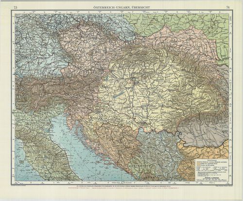
| Title | Österreich-Ungarn. Übersicht. |
| Main title | Az Osztrák-Magyar Monarchia áttekintő térképe. |
659. Ungarn, Galizien, Bukowina, Croatien, Slavonien, Wojwodina, ... [B IX a 1142]
Institute and Museum of Military History •
B IX a
•
B IX Ausztria–Magyarország
•
B I–XV. Európa
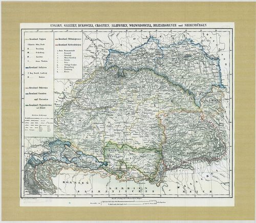
| Title | Ungarn, Galizien, Bukowina, Croatien, Slavonien, Wojwodina, Militairgrenze und Siebenbürgen. |
| Main title | Magyarország, Galícia, Bukovina, Horvátország, a Vajdaság, a Határőrvidékek és Erdély térképe 1840-ből. |
660. Hungaria Utraque... [B IX a 1143]
Institute and Museum of Military History •
B IX a
•
B IX Ausztria–Magyarország
•
B I–XV. Európa
| Title | Hungaria Utraque... |
| Main title | Magyarország térképe. |
661. Novissima et Accuratissima totius Hungariae tabula... [B IX a 1144]
Institute and Museum of Military History •
B IX a
•
B IX Ausztria–Magyarország
•
B I–XV. Európa
| Title | Novissima et Accuratissima totius Hungariae tabula... |
| Main title | Magyarország térképe. |
662. Transylvania. [B IX a 1145]
Institute and Museum of Military History •
B IX a
•
B IX Ausztria–Magyarország
•
B I–XV. Európa
| Title | Transylvania. |
| Main title | Erdély térképe. |
663. Karte von Innerösterreich, oder das Herzogthum Steyermark, K... [B IX a 1146]
Institute and Museum of Military History •
B IX a
•
B IX Ausztria–Magyarország
•
B I–XV. Európa
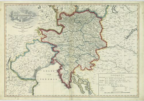
| Title | Karte von Innerösterreich, oder das Herzogthum Steyermark, Kaernthen und Krain mit der Grafschaft Görz und dem Triester Gebiethe. |
| Main title | Belső-Ausztria (A Stájer Hercegség, Karintia, Krajna, a Görz-i Hercegség és a Trieszti terület) térképe. |
664. Karte der Österreichischen Monarchie. [B IX a 1147]
Institute and Museum of Military History •
B IX a
•
B IX Ausztria–Magyarország
•
B I–XV. Európa
| Title | Karte der Österreichischen Monarchie. |
| Main title | Az Osztrák Monarchia térképe 1861-ből. |
665. Österreich-Ungarn. [B IX a 1148]
Institute and Museum of Military History •
B IX a
•
B IX Ausztria–Magyarország
•
B I–XV. Európa
| Title | Österreich-Ungarn. |
| Main title | Az Osztrák-Magyar Monarchia térképe 1912-ből. |
666. Mappa Chorographica per quam Communicatio Sclavoniae... [B IX a 1149]
Institute and Museum of Military History •
B IX a
•
B IX Ausztria–Magyarország
•
B I–XV. Európa
| Title | Mappa Chorographica per quam Communicatio Sclavoniae... |
| Main title | Földrajzi térkép, amelynek segítségével Szlavónia közlekedését ábrázolják. |
667. Mappa Lineae Limitaneae Particularis, Sirmiensis. [B IX a 1150]
Institute and Museum of Military History •
B IX a
•
B IX Ausztria–Magyarország
•
B I–XV. Európa
| Title | Mappa Lineae Limitaneae Particularis, Sirmiensis. |
| Main title | A szerémségi határszakasz résztérképe. |
668. Mappa Geographica, Lineae Limitaneae partem Szluinensem comp... [B IX a 1151]
Institute and Museum of Military History •
B IX a
•
B IX Ausztria–Magyarország
•
B I–XV. Európa
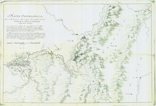
| Title | Mappa Geographica, Lineae Limitaneae partem Szluinensem compendiose exhibens... |
| Main title | Geográfiai térkép, amely a szluini határrészt ábrázolja. |
669. Tractus Unnae fl. inter Novi et Asperkanova Kula, Burgar, Tu... [B IX a 1152]
Institute and Museum of Military History •
B IX a
•
B IX Ausztria–Magyarország
•
B I–XV. Európa
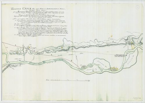
| Title | Tractus Unnae fl. inter Novi et Asperkanova Kula, Burgar, Turcis, dictam... |
| Main title | Az Una folyó Novi és a törökök által Burgar-nak nevezett Asperkanova Kula között. |
670. [Az Una folyó egy szakasza, Novi és környéke.] [B IX a 1153]
Institute and Museum of Military History •
B IX a
•
B IX Ausztria–Magyarország
•
B I–XV. Európa
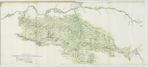
| Title | [Az Una folyó egy szakasza, Novi és környéke.] |
671. Le Grand Royaume de Hongrie… [B IX a 1154]
Institute and Museum of Military History •
B IX a
•
B IX Ausztria–Magyarország
•
B I–XV. Európa
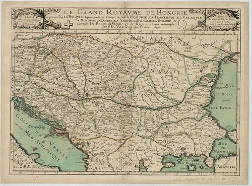
| Title | Le Grand Royaume de Hongrie… |
| Main title | A Magyar Királyság térképe. |
672. Regnum Hungariae cum consignis regionibus. [B IX a 1156]
Institute and Museum of Military History •
B IX a
•
B IX Ausztria–Magyarország
•
B I–XV. Európa
| Title | Regnum Hungariae cum consignis regionibus. |
| Main title | A Magyar Királyság a szomszédos területekkel. |
673. Karte von Hungarn. [B IX a 1159]
Institute and Museum of Military History •
B IX a
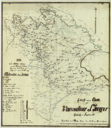
•
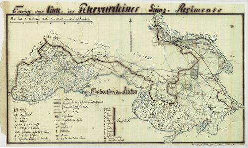
B IX Ausztria–Magyarország
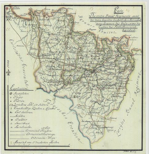
•
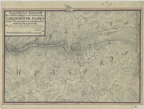
B I–XV. Európa
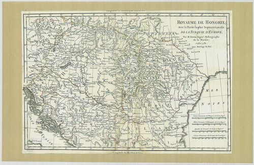
| Title | Karte von Hungarn. |
| Main title | Magyarország térképe az I. katonai felmérés alapján, a Neu térképhez hasonló. |
674. Karte des Königreiches Galizien. [B IX a 1160]
Institute and Museum of Military History •
B IX a
•
B IX Ausztria–Magyarország
•
B I–XV. Európa
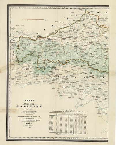
| Title | Karte des Königreiches Galizien. |
| Main title | A Galíciai Királyság térképe. |
675. [A Magyar Királyság és a határoló országok térképe. Az I. ka... [B IX a 1161]
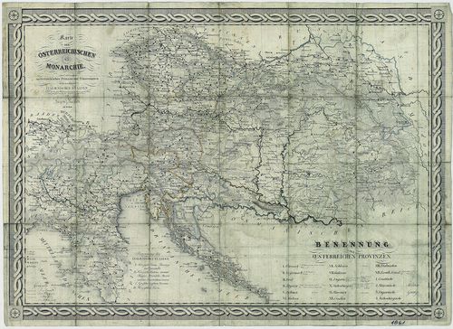
Institute and Museum of Military History •
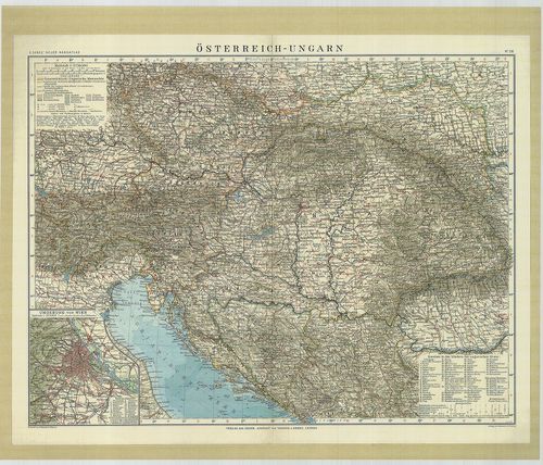
B IX a
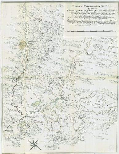
•
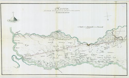
B IX Ausztria–Magyarország
•
B I–XV. Európa
| Title | [A Magyar Királyság és a határoló országok térképe. Az I. kat. felm. alapján készült térkép, befejezetlen.] |
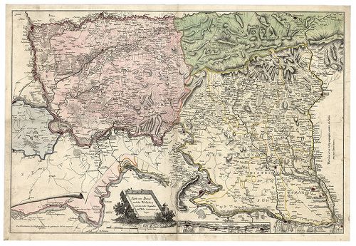
676. Der Temesvarer Bannat. [B IX a 1166]
Institute and Museum of Military History •
B IX a
•
B IX Ausztria–Magyarország
•
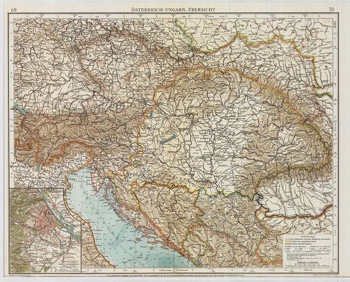
B I–XV. Európa
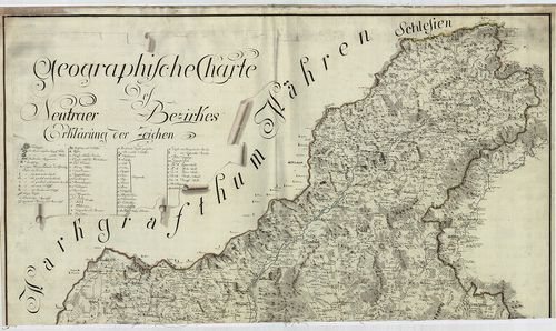
| Title | Der Temesvarer Bannat. |
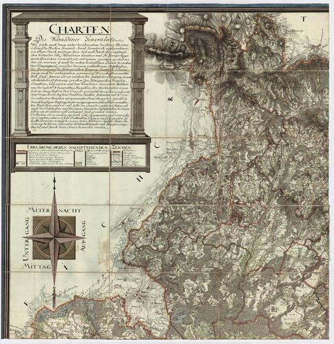
| Main title | A Temesi Bánság térképe, melynek felmérését Szavoyai Jenő irányította. |
677. Österreich–Ungarn, Übersicht. [B IX a 1167]
Institute and Museum of Military History •
B IX a
•
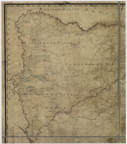
B IX Ausztria–Magyarország
•
B I–XV. Európa
| Title | Österreich–Ungarn, Übersicht. |
| Main title | Az Osztrák–Magyar Monarchia áttekintő térképe. Az „Andrees Allgemeines Handatlas” 69–70. o. nagyítva. |
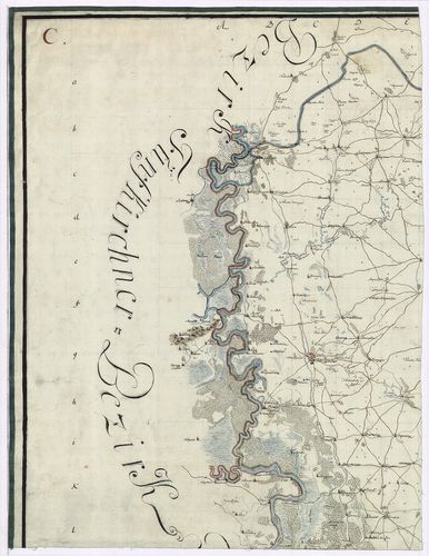
678. Geographische Charte des Neutraer Bezirkes. [B IX a 1168]
Institute and Museum of Military History •
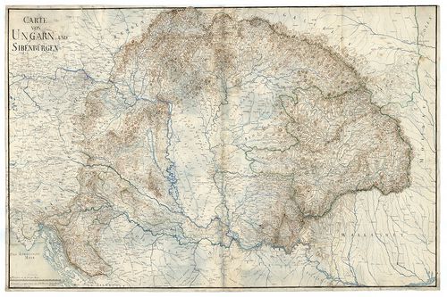
B IX a
•
B IX Ausztria–Magyarország
•
B I–XV. Európa
| Title | Geographische Charte des Neutraer Bezirkes. |
| Main title | A Nyitrai kerület földrajzi térképe az I. katonai felmérés alapján. |
679. Charten des Warasdiner Generalats. [B IX a 1169]
Institute and Museum of Military History •
B IX a
•
B IX Ausztria–Magyarország
•
B I–XV. Európa
| Title | Charten des Warasdiner Generalats. |
| Main title | A Varasdi Határőrvidék levezetett térképe az I. katonai felmérés alapján. |
680. Geographische Charte des Neusoller Bezirks. [B IX a 1170]
Institute and Museum of Military History •
B IX a
•
B IX Ausztria–Magyarország
•
B I–XV. Európa
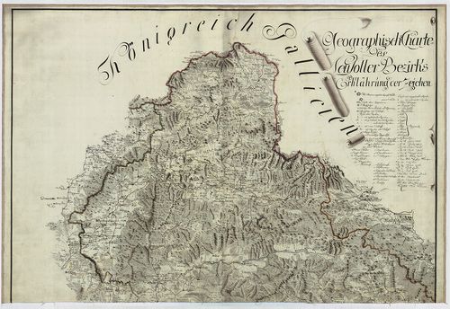
| Title | Geographische Charte des Neusoller Bezirks. |
| Main title | A Besztercebányai kerület földrajzi térképe az I. katonai felmérés alapján. |
681. Militair Charte der Banal Grenze… [B IX a 1171]
Institute and Museum of Military History •
B IX a
•
B IX Ausztria–Magyarország
•
B I–XV. Európa

| Title | Militair Charte der Banal Grenze… |
| Main title | A Báni Határőrvidék katonai térképe az I. kat. felm. alapján. |
682. Charte des Carlstaedter Generalats … [B IX a 1172]
Institute and Museum of Military History •
B IX a
•
B IX Ausztria–Magyarország
•
B I–XV. Európa

| Title | Charte des Carlstaedter Generalats … |
| Main title | A Károlyvárosi katonai térképe az I. kat. felm. alapján. |
683. Mappa von Provincial Croatien. [B IX a 1173]
Institute and Museum of Military History •
B IX a
•
B IX Ausztria–Magyarország
•
B I–XV. Európa
| Title | Mappa von Provincial Croatien. |
| Main title | Horvátország térképe az I. kat. felm. alapján. |
684. Geographische Charte des Temeswarer Bezirks … [B IX a 1174]
Institute and Museum of Military History •
B IX a
•
B IX Ausztria–Magyarország
•
B I–XV. Európa
| Title | Geographische Charte des Temeswarer Bezirks … |
| Main title | A Temesvári kerület földrajzi térképe az I. kat. felm. alapján. |
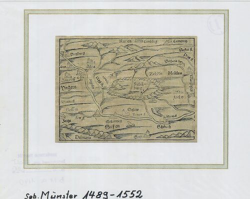
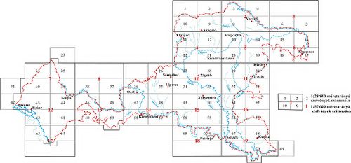
685. A Tabula Hubgariae és változatai. [B IX a 1176]
Institute and Museum of Military History •
B IX a
•
B IX Ausztria–Magyarország
•
B I–XV. Európa
| Title | A Tabula Hubgariae és változatai. |
| Main title | A Lázár és Zsámboky térképek (XVI. sz.) faximile kiadása. |
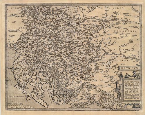
686. Illyricum. [B IX a 1178]
Institute and Museum of Military History •
B IX a
•
B IX Ausztria–Magyarország
•
B I–XV. Európa
| Title | Illyricum. |
| Main title | Illíria térképe. |
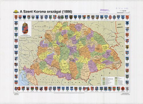
687. A Szent Korona országai (1886). [B IX a 1182]
Institute and Museum of Military History •
B IX a
•
B IX Ausztria–Magyarország
•
B I–XV. Európa
| Title | A Szent Korona országai (1886). |
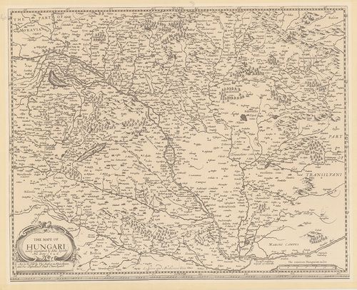
688. The mape of Hungari....1626. [B IX a 1183]
Institute and Museum of Military History •
B IX a
•
B IX Ausztria–Magyarország
•
B I–XV. Európa
| Title | The mape of Hungari....1626. |
| Main title | Magyarország térképe, 1626. |
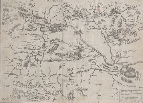
689. Das Khynigreich Hungern... [B IX a 1199]
Institute and Museum of Military History •
B IX a
•
B IX Ausztria–Magyarország
•
B I–XV. Európa
| Title | Das Khynigreich Hungern... |
| Main title | A Magyar Királyság. Az 1566-os török hadjárat főbb várostromainak bemutatása. |
690. Regni Hungariae cum adiuncta Transylvania... [B IX a 1200]
Institute and Museum of Military History •
B IX a
•
B IX Ausztria–Magyarország
•
B I–XV. Európa
| Title | Regni Hungariae cum adiuncta Transylvania... |
| Main title | A Magyar Királyság és Erdély térképe. |
691. Carte von Ungarn und Siebenbürgen. [B IX a 1201]
Institute and Museum of Military History •
B IX a
•
B IX Ausztria–Magyarország
•
B I–XV. Európa
| Title | Carte von Ungarn und Siebenbürgen. |
| Main title | A Magyar Királyság és Erdély térképe. |
692. Carte von Ungarn und Siebenbürgen. [B IX a 1202]
Institute and Museum of Military History •
B IX a
•
B IX Ausztria–Magyarország
•
B I–XV. Európa
| Title | Carte von Ungarn und Siebenbürgen. |
| Main title | A Magyar Királyság és Erdély térképe. |
693. Charte von den Königreichen Ungarn, Kroatien, und Slavonien ... [B IX a 1203]
Institute and Museum of Military History •
B IX a
•
B IX Ausztria–Magyarország
•
B I–XV. Európa
| Title | Charte von den Königreichen Ungarn, Kroatien, und Slavonien mit dem Grossfürstenthume Siebenbürgen. |
| Main title | A Magyar Királyság, Horvátország, Szlavónia és Erdély térképe. (nyugati rész h.) |
694. Magyar Ország közönséges földképe. [B IX a 1204]
Institute and Museum of Military History •
B IX a
•
B IX Ausztria–Magyarország
•
B I–XV. Európa

| Title | Magyar Ország közönséges földképe. |
695. Tabula generalis Regni Hungariae, Croatiae et Slavoniae nec ... [B IX a 1205]
Institute and Museum of Military History •
B IX a
•
B IX Ausztria–Magyarország
•
B I–XV. Európa
| Title | Tabula generalis Regni Hungariae, Croatiae et Slavoniae nec non Magni Principatus Transylvaniae… |
| Main title | A Magyar Királyság, Horvát-Szlavónia és Erdély általános térképe 1848-ban. Tartományi színezés. |
696. [Trencsén-, Túróc-, Árva-, Liptó-, Szepes- és Sáros megyék t... [B IX a 1206]
Institute and Museum of Military History •
B IX a
•
B IX Ausztria–Magyarország
•
B I–XV. Európa
| Title | [Trencsén-, Túróc-, Árva-, Liptó-, Szepes- és Sáros megyék területét ábrázoló általános térkép 1831-ből, készült Aulich százados irányításával, az I. katonai felmérés alapján.] |
697. Karte vom Banat und der Wallachey... [B IX a 1207]
Institute and Museum of Military History •
B IX a
•
B IX Ausztria–Magyarország
•
B I–XV. Európa
| Title | Karte vom Banat und der Wallachey... |
| Main title | A Temesi Bánság és Havasalföld térképe. |
698. Der Temesvarer Bannat. [B IX a 1208]
Institute and Museum of Military History •
B IX a
•
B IX Ausztria–Magyarország
•
B I–XV. Európa
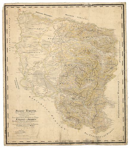
| Title | Der Temesvarer Bannat. |
| Main title | A Temesi Bánság "Mercy" féle térképének a kicsinyitésével készült térkép. (Lásd: B IX a 1166) |
699. [A Temesi Bánság topográfiai térképe.] [B IX a 1209]
Institute and Museum of Military History •
B IX a
•
B IX Ausztria–Magyarország
•
B I–XV. Európa
| Title | [A Temesi Bánság topográfiai térképe.] |
700. Carte von dem Temesvarer Banat und dem König. Servien, nebst... [B IX a 1210]
Institute and Museum of Military History •
B IX a
•
B IX Ausztria–Magyarország
•
B I–XV. Európa
| Title | Carte von dem Temesvarer Banat und dem König. Servien, nebst einen Theil von Ungarn, Slavonien und Bosnien. |
| Main title | A Temesi Bánság és a Szerb Királyság, valamint a Magyar Királyság, Szlavónia és Bosznia egy részének totográfiai térképe. |