1. Facies orbis septentrionalis ad mentem Ptolemaei. A. H. XXXI... [B VI a 2]
Institute and Museum of Military History •
B VI a
•
B VI Anglia, Skócia és Írország
•
B I–XV. Európa
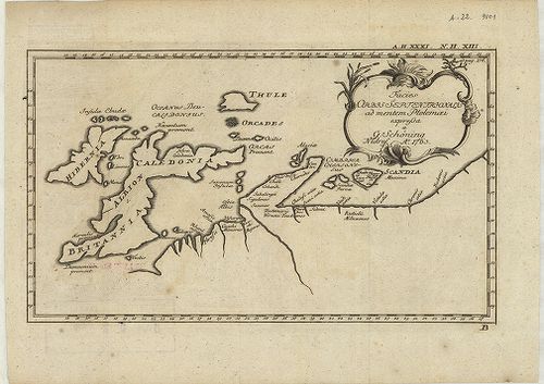
| Title | Facies orbis septentrionalis ad mentem Ptolemaei. A. H. XXXI. N. H. XIII. |
| Main title | Az északi földrész térképe: Nagybritannia és Írország Ptolemaiosz elképzelése szerint. |
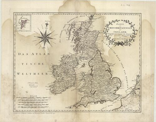
2. Tabula novissima accuratissima Regnorum Angliae, Scoatiae, H... [B VI a 7]
Institute and Museum of Military History •
B VI a
•
B VI Anglia, Skócia és Írország
•
B I–XV. Európa
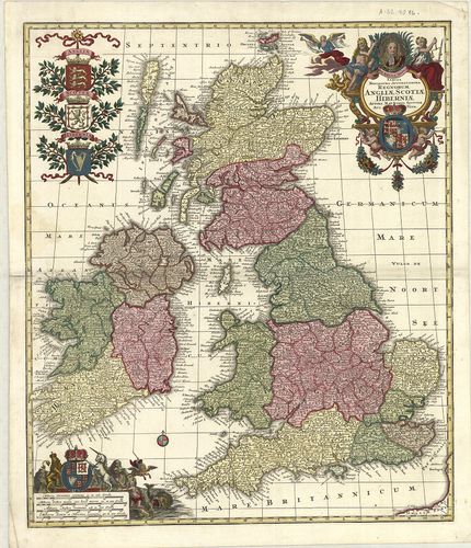
| Title | Tabula novissima accuratissima Regnorum Angliae, Scoatiae, Hibérniae. |
| Main title | Anglia, Skócia és Írország általános térképe a 18. században. |
3. Anglia, Scotia et Hibernia cum Insulis vicinis. [B VI a 8]
Institute and Museum of Military History •
B VI a
•
B VI Anglia, Skócia és Írország
•
B I–XV. Európa
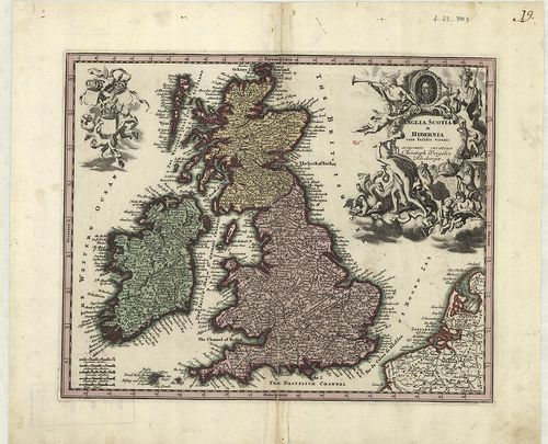
| Title | Anglia, Scotia et Hibernia cum Insulis vicinis. |
| Main title | Anglia, Skócia és Írország általános térképe a 18. században. |
4. Charte der vereinigten Königeriche Grossbritannien und Irlan... [B VI a 9]
Institute and Museum of Military History •
B VI a
•
B VI Anglia, Skócia és Írország
•
B I–XV. Európa
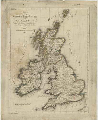
| Title | Charte der vereinigten Königeriche Grossbritannien und Irland. |
| Main title | Nagybritannia és Írország általános térképe 1806-ban. |
5. Die Britischen Inseln und das umliegende Meer. [B VI a 10]
Institute and Museum of Military History •
B VI a
•
B VI Anglia, Skócia és Írország
•
B I–XV. Európa
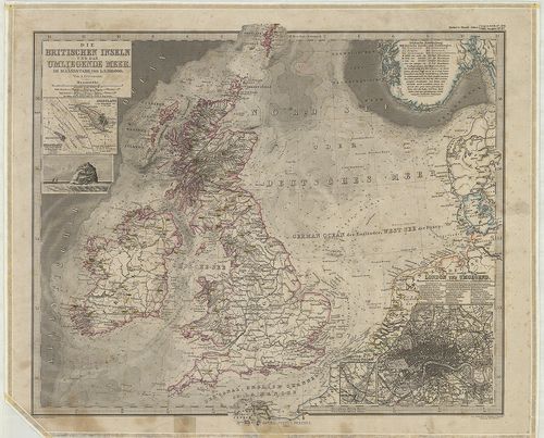
| Title | Die Britischen Inseln und das umliegende Meer. |
| Main title | 3 mt.: 1. Helgoland. |
| Subject | 2. Helgoland und die Düne. |
6. Schlag nach über England. [B VI a 11]
Institute and Museum of Military History •
B VI a
•
B VI Anglia, Skócia és Írország
•
B I–XV. Európa
| Title | Schlag nach über England. |
| Main title | 2 térk.: 1. Grossbritannien und Irland. |
| Subject | (Nagybritannia és Írország.) 2. Politische Karte der Erde. (A világ politikai térképe.) |
7. A General Map of Great Britain and Ireland… – Regnorum Magna... [B VI a 12]
Institute and Museum of Military History •
B VI a
•
B VI Anglia, Skócia és Írország
•
B I–XV. Európa
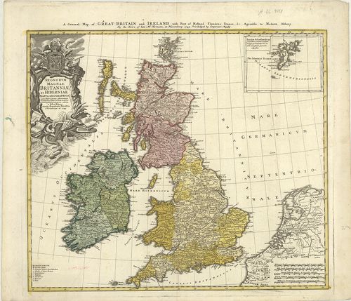
| Title | A General Map of Great Britain and Ireland… – Regnorum Magnae Britanniae et Hiberniae… |
| Main title | Mt.: Insulae Schetlandicae. (Shetland-szk.) |
| Subject | Nagy-Britannia és Írország általános térképe 1749-ben. |
8. British Atlas, Comprising separate maps of every County in E... [B VI a 13/1]
Institute and Museum of Military History •
B VI a
•
B VI Anglia, Skócia és Írország
•
B I–XV. Európa
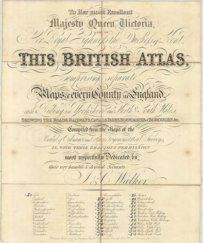
| Title | British Atlas, Comprising separate maps of every County in England… |
| Main title | 1. Northamptonshire. 2. Northumberland. 3. Nottinghamshire. 4. Oxfordshire. 5. Rutlandshire. 6. Shorpshire. 7. Somersetshire. 8. Staffordshire. 9. Suffolk. 10. Surrey. 11. Sussex. 12. Warwickshire. 13. Wiltshire. 14. Yorkshire, West Riding. 15. Yorkshire, North Riding. 16. Wales, North West. 17. Wales, North-East. 18. Wales, South-West. 19. Wales, South-East.Anglia grófságainak általános térképe 1837-ben. |
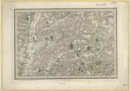
9. Index shewing the progress of the ordnance survey of the Sou... [B VI a 14]
Institute and Museum of Military History •
B VI a
•
B VI Anglia, Skócia és Írország
•
B I–XV. Európa
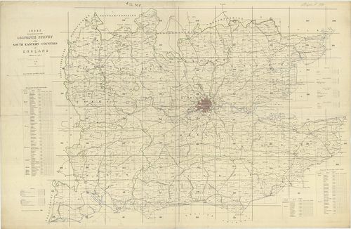
| Title | Index shewing the progress of the ordnance survey of the South Eastern Counties of England. |
| Main title | Anglia DK-i grófságainak katonai térképe. |
10. Anglia Skotzia és Irlandia földképe. [B VI a 15]
Institute and Museum of Military History •
B VI a
•
B VI Anglia, Skócia és Írország
•
B I–XV. Európa
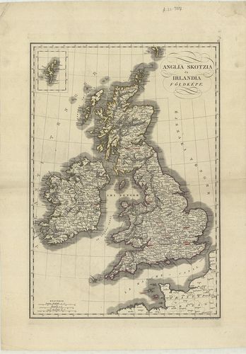
| Title | Anglia Skotzia és Irlandia földképe. |
| Main title | Anglia, Skócia és Írország térképe 1840 körül. |
11. Karte von Grossbritannien und Ireland. X. [B VI a 16]
Institute and Museum of Military History •
B VI a
•
B VI Anglia, Skócia és Írország
•
B I–XV. Európa
| Title | Karte von Grossbritannien und Ireland. X. |
| Main title | Nagy-Britannia és Írország általános térképe 1795-ben. |
12. Das Königreich England. XI. [B VI a 17]
Institute and Museum of Military History •
B VI a
•
B VI Anglia, Skócia és Írország
•
B I–XV. Európa
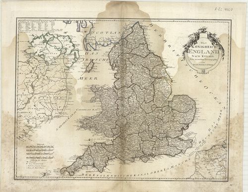
| Title | Das Königreich England. XI. |
| Main title | Az Angol Királyság térképe 1795-ben. |
13. Karte von Scotland. XII. [B VI a 18]
Institute and Museum of Military History •
B VI a
•
B VI Anglia, Skócia és Írország
•
B I–XV. Európa
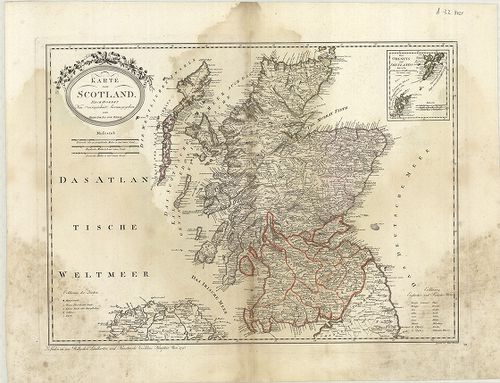
| Title | Karte von Scotland. XII. |
| Main title | Skócia térképe 1795-ben. |
14. Karte von Ireland. XIII. [B VI a 19]
Institute and Museum of Military History •
B VI a
•
B VI Anglia, Skócia és Írország
•
B I–XV. Európa
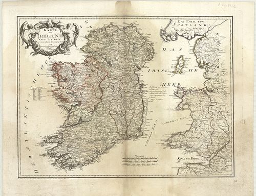
| Title | Karte von Ireland. XIII. |
| Main title | Írország térképe 1795-ben. |
15. Insularum Britannicarum. [B VI a 20]
Institute and Museum of Military History •
B VI a
•
B VI Anglia, Skócia és Írország
•
B I–XV. Európa
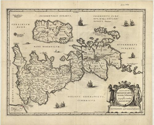
| Title | Insularum Britannicarum. |
| Main title | A Brit-szigetek térképe a XVI. században. |
16. Parte meridionale del Regno D’Inghilterra. [B VI a 21]
Institute and Museum of Military History •
B VI a
•
B VI Anglia, Skócia és Írország
•
B I–XV. Európa
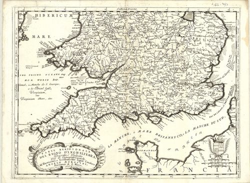
| Title | Parte meridionale del Regno D’Inghilterra. |
| Main title | Az Angol Királyság déli részének térképe 1690 körül. |
17. General Survey of England and Wales. An entirely new and acc... [B VI a 22/3]
Institute and Museum of Military History •
B VI a
•
B VI Anglia, Skócia és Írország
•
B I–XV. Európa
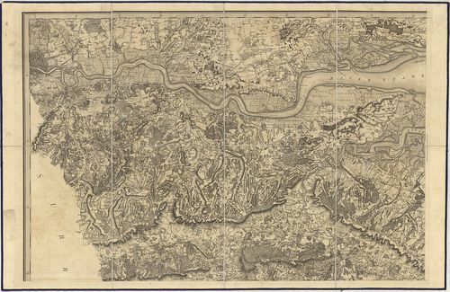
| Title | General Survey of England and Wales. An entirely new and accurate Survey of the County of Kent… |
| Main title | Kent grófság térképe 1801-ben. |
18. Neueste Karte von Grossbritannien und Ireland. [B VI a 25]
Institute and Museum of Military History •
B VI a
•
B VI Anglia, Skócia és Írország
•
B I–XV. Európa
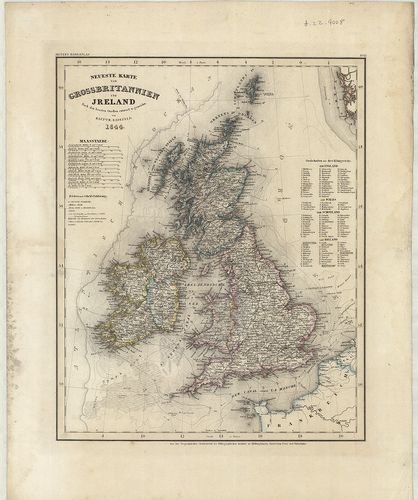
| Title | Neueste Karte von Grossbritannien und Ireland. |
| Main title | Nagy-Britannia és Írország térképe 1844-ben. |
19. Neueste Karte von England. [B VI a 26]
Institute and Museum of Military History •
B VI a
•
B VI Anglia, Skócia és Írország
•
B I–XV. Európa
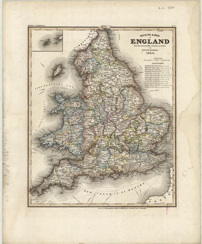
| Title | Neueste Karte von England. |
| Main title | Anglia térképe 1844-ben. |
20. Neueste Karte von Schotland. [B VI a 27]
Institute and Museum of Military History •
B VI a
•
B VI Anglia, Skócia és Írország
•
B I–XV. Európa
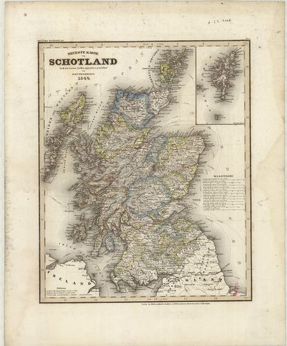
| Title | Neueste Karte von Schotland. |
| Main title | Skócia térképe 1844-ben. |
21. Neuestes Karte von Ireland. [B VI a 28]
Institute and Museum of Military History •
B VI a
•
B VI Anglia, Skócia és Írország
•
B I–XV. Európa
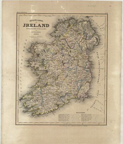
| Title | Neuestes Karte von Ireland. |
| Main title | Írország térképe 1844-ben. |
22. Map of Scotland. [B VI a 30]
Institute and Museum of Military History •
B VI a
•
B VI Anglia, Skócia és Írország
•
B I–XV. Európa
| Title | Map of Scotland. |
| Main title | Skócia térképe 1810-ben. |
23. Scotland with its Islands. [B VI a 31]
Institute and Museum of Military History •
B VI a
•
B VI Anglia, Skócia és Írország
•
B I–XV. Európa
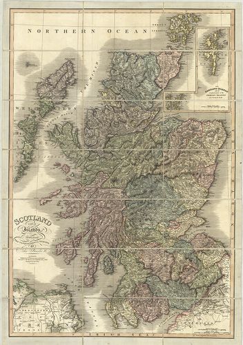
| Title | Scotland with its Islands. |
| Main title | Mt.: The Shetland Islands. (Shetland szk.) |
| Subject | Skócia és szigeteinek térképe 1824-ben. |
24. Grossbritannien und Irland. – Velhagen und Klasings Karte. [B VI a 34]
Institute and Museum of Military History •
B VI a
•
B VI Anglia, Skócia és Írország
•
B I–XV. Európa
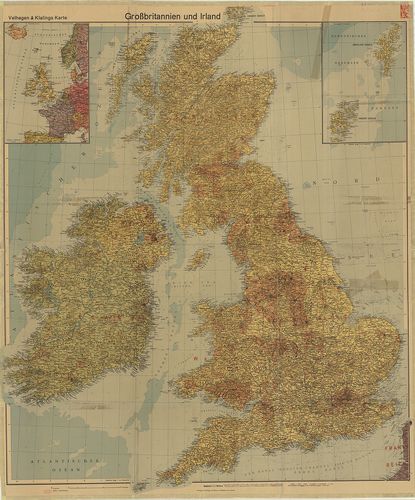
| Title | Grossbritannien und Irland. – Velhagen und Klasings Karte. |
| Main title | Mt.: [Ny-Európa.] A hátoldalon: [Nagy-Britannia gyarmatai.] |
| Subject | Nagy-Britannia és Írország térképe 1940-ben. |
25. [Nagy-Britannia–Írország.] [B VI a 38]
Institute and Museum of Military History •
B VI a
•
B VI Anglia, Skócia és Írország
•
B I–XV. Európa
| Title | [Nagy-Britannia–Írország.] |
26. [Skócia.] [B VI a 38/1]
Institute and Museum of Military History •
B VI a
•
B VI Anglia, Skócia és Írország
•
B I–XV. Európa
| Title | [Skócia.] |
27. Scozia. [B VI a 40]
Institute and Museum of Military History •
B VI a
•
B VI Anglia, Skócia és Írország
•
B I–XV. Európa
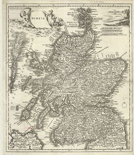
| Title | Scozia. |
| Main title | Skócia térképe a 18. században. |
28. Irlanda. [B VI a 41]
Institute and Museum of Military History •
B VI a
•
B VI Anglia, Skócia és Írország
•
B I–XV. Európa
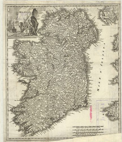
| Title | Irlanda. |
| Main title | Írország térképe a 18. században. |
29. Ireland. [B VI a 42]
Institute and Museum of Military History •
B VI a
•
B VI Anglia, Skócia és Írország
•
B I–XV. Európa
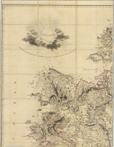
| Title | Ireland. |
| Main title | Írország térképe 1811-ben. |
30. Ireland. [B VI a 45]
Institute and Museum of Military History •
B VI a
•
B VI Anglia, Skócia és Írország
•
B I–XV. Európa
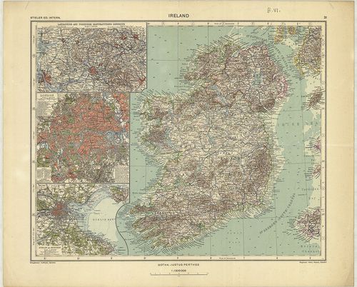
| Title | Ireland. |
| Main title | 3 mt. 1. Lancashire and Yorkshire Manufacturing. (Lancashire és Yorkshire ipari körzetei.) 2. London. 3. Dublin and Suburs. (Dublin és külvárosa.) |
| Subject | Írország térképe 1935-ben. |
31. Regionis qvae est circa Londinvm. – Ausführliche Geographisc... [B VI a 46]
Institute and Museum of Military History •
B VI a
•
B VI Anglia, Skócia és Írország
•
B I–XV. Európa
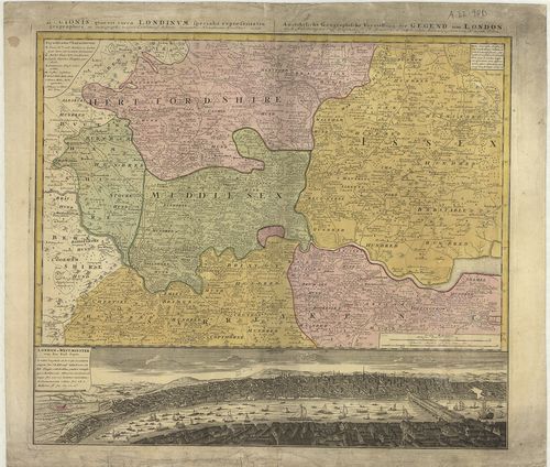
| Title | Regionis qvae est circa Londinvm. – Ausführliche Geographische Vorstellung der Gegend um London. |
| Main title | London és környékének térképe 1742-ben. |
32. Mogg’s New Map of England and Wales with part of Scotland. [B VI a 48]
Institute and Museum of Military History •
B VI a
•
B VI Anglia, Skócia és Írország
•
B I–XV. Európa
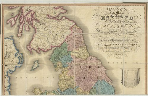
| Title | Mogg’s New Map of England and Wales with part of Scotland. |
| Main title | Anglia, Wales és Skócia egy részének térképe 1823-ban. |
33. Brit-szigetek. [B VI a 52]
Institute and Museum of Military History •
B VI a
•
B VI Anglia, Skócia és Írország
•
B I–XV. Európa
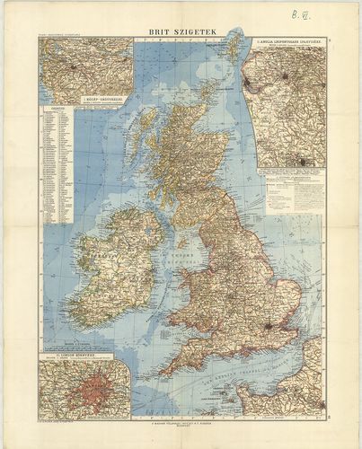
| Title | Brit-szigetek. |
| Main title | 3 mt. 1. Közép-Skótország. 2. Anglia legfontosabb iparvidéke. 3. London környéke. |
34. Brit-szigetek. [B VI a 53]
Institute and Museum of Military History •
B VI a
•
B VI Anglia, Skócia és Írország
•
B I–XV. Európa
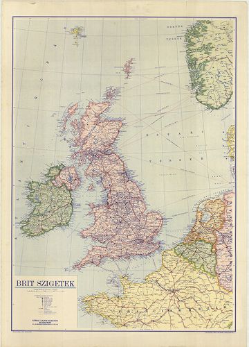
| Title | Brit-szigetek. |
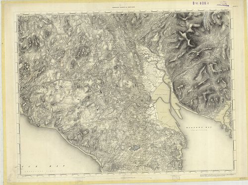
35. Index to the Ordnance Survey of Yorkshire. [B VI a 61]
Institute and Museum of Military History •
B VI a
•
B VI Anglia, Skócia és Írország
•
B I–XV. Európa
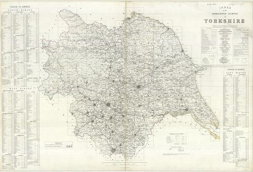
| Title | Index to the Ordnance Survey of Yorkshire. |
| Main title | Yorkshire topográfiai térképeinek áttekintő és csatlakozó térképlapjai 1854–56-ban. |
36. The Border – Administrative Areas Edition. [B VI a 63]
Institute and Museum of Military History •
B VI a
•
B VI Anglia, Skócia és Írország
•
B I–XV. Európa
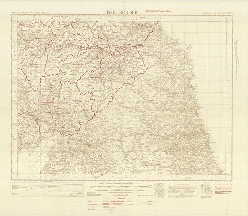
| Title | The Border – Administrative Areas Edition. |
| Main title | Közép-Anglia közigazgatási térképe, autóutakkal 1950-ből. |
37. Index to the Ordnance Survey of the County of Durham. [B VI a 64]
Institute and Museum of Military History •
B VI a
•
B VI Anglia, Skócia és Írország
•
B I–XV. Európa
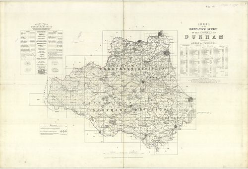
| Title | Index to the Ordnance Survey of the County of Durham. |
| Main title | Durham-grófság topográfiai térképeinek áttekintő lapja 1878-ban. |
38. Ten-Mile Aviation Map of Great Britain. – Ten Mile Map of Gr... [B VI a 75]
Institute and Museum of Military History •
B VI a
•
B VI Anglia, Skócia és Írország
•
B I–XV. Európa
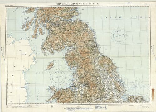
| Title | Ten-Mile Aviation Map of Great Britain. – Ten Mile Map of Great Britain. Sheet 2. |
| Main title | Nagy-Britannia középső részének térképe 1930-ban. |
39. Contoured Road Map of East Kent. – East Kent. Sheet 117. [B VI a 77]
Institute and Museum of Military History •
B VI a
•
B VI Anglia, Skócia és Írország
•
B I–XV. Európa
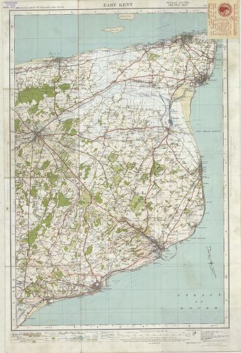
| Title | Contoured Road Map of East Kent. – East Kent. Sheet 117. |
| Main title | Kent-tartomány K-i részének térképe 1928-ban. |
40. Map of Barnard Castle and District. – Barnard Castle and Kir... [B VI a 78]
Institute and Museum of Military History •
B VI a
•
B VI Anglia, Skócia és Írország
•
B I–XV. Európa
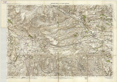
| Title | Map of Barnard Castle and District. – Barnard Castle and Kirk by Stephen. Sheet 14. |
| Main title | Barnard Castle és környékének térképe 1907-ben. |
41. Grossbritannien und Irland. Schulhandkarte. [B VI a 81]
Institute and Museum of Military History •
B VI a
•
B VI Anglia, Skócia és Írország
•
B I–XV. Európa
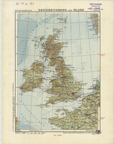
| Title | Grossbritannien und Irland. Schulhandkarte. |
| Main title | Nagy-Britannia és Írország térképe 1950-ben. |
42. Nagy Britania vagy is Anglia, Skóczia, Hibernia. [B VI a 84]
Institute and Museum of Military History •
B VI a
•
B VI Anglia, Skócia és Írország
•
B I–XV. Európa
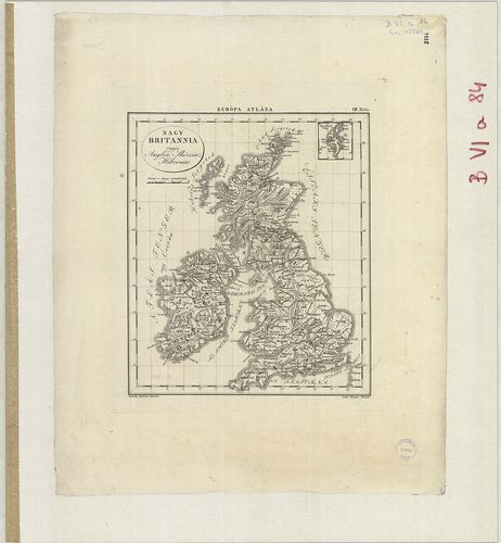
| Title | Nagy Britania vagy is Anglia, Skóczia, Hibernia. |