241. Post Karte von der Halbinsel Taurien oder Krim. [B XI c 26]
Institute and Museum of Military History •
B XI c
•
B XI Oroszország
•
B I–XV. Európa
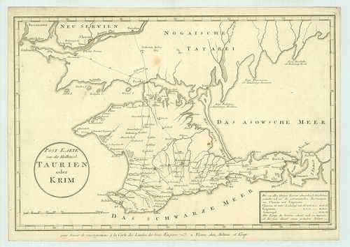
| Title | Post Karte von der Halbinsel Taurien oder Krim. |
| Main title | A Krím-félsziget postaúttérképe 1800 körül. |
242. Carte de la partie européenne de l’Empire de Russie… [B XI c 27]
Institute and Museum of Military History •
B XI c
•
B XI Oroszország
•
B I–XV. Európa
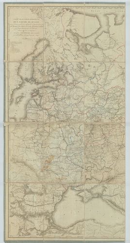
| Title | Carte de la partie européenne de l’Empire de Russie… |
| Main title | Európai Oroszország kormányzósági, járási és vámhatárai 1809-ben. |
243. Carte des routes de posta de la Russie Européenne. [B XI c 27/1]
Institute and Museum of Military History •
B XI c
•
B XI Oroszország
•
B I–XV. Európa
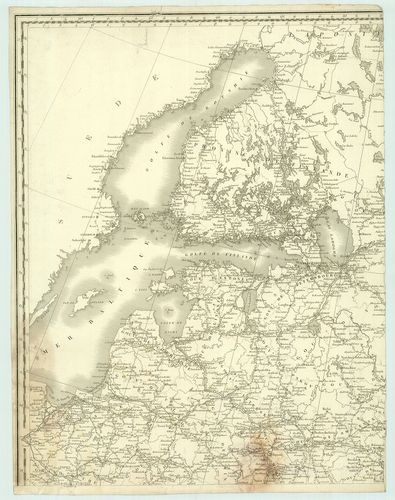
| Title | Carte des routes de posta de la Russie Européenne. |
| Main title | Európai Oroszország postai és úttérképe 1812-ben. |
244. Generalnaja karta Podol’szkoj Gubernii-General Karte des Gou... [B XI c 29]
Institute and Museum of Military History •
B XI c
•
B XI Oroszország
•
B I–XV. Európa
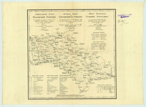
| Title | Generalnaja karta Podol’szkoj Gubernii-General Karte des Gouvernements Podolien-Mappa Generalna Gubernii Podolskiéy. |
| Main title | A Podoliai kormányzóság posta, út- és állomás térképe. |
245. Übersicht der Marsch-Linie und der Beschaffenheit der oberen... [B XI c 30]
Institute and Museum of Military History •
B XI c
•
B XI Oroszország
•
B I–XV. Európa
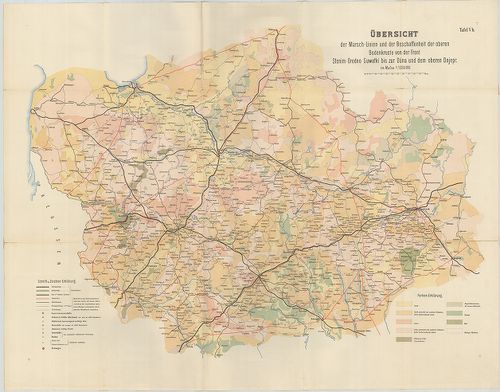
| Title | Übersicht der Marsch-Linie und der Beschaffenheit der oberen Bodenkruste von der Front Słonim,-Grodno, Suwałki bis zur Düna und der oberen Dnjepr. Tafel Vb. |
| Main title | Talaj és úttérkép Szlonyim-Grodno, Suwalki, a Daugava és a Dnyeper-folyók Riga, Kaunas, Minszk, Szmolenszk és Pszkov közötti területről. |
246. Pocstovaja karta. Roszszijszkoj Imperii. Csaszt 1. Velikoe k... [B XI c 32]
Institute and Museum of Military History •
B XI c
•
B XI Oroszország
•
B I–XV. Európa
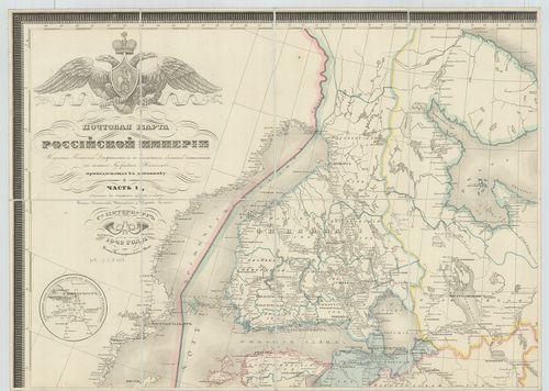
| Title | Pocstovaja karta. Roszszijszkoj Imperii. Csaszt 1. Velikoe knjazsesztvo Finlandszkoe i carsztvo Polszkoe. |
| Main title | Mt.: Izjasznenie vszeh pocstovüh dorog v okresznoszti Szt. Peterburga. (Szentpétervár–Leningrád környéki postautak) csaszt. 2. Szoderzsascsaja Szibirszkija Gubernii. Jakutszkuja oblaszt i Primorszkija upravlenie. |
| Subject | Az Orosz Birodalom, Finnország a cári Lengyelország, ázsiai Oroszország, szibériai kormányzóságok, Jakut terület és a tengerparti kormányzóságok posta út- és állomás térképe és névjegyzéke 1842-ből. |
247. Post- und Industrie-Karte des Königreichs Polen… Karta poczt... [B XI c 34]
Institute and Museum of Military History •
B XI c
•
B XI Oroszország
•
B I–XV. Európa
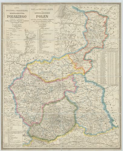
| Title | Post- und Industrie-Karte des Königreichs Polen… Karta pocztowa i przemislowa królestwa… Polskiego… |
| Main title | A Lengyel Királyság postai és ipari térképe 1855-ben. |
248. Pocstovo-Telegrafnaja karta Roszszijszkoj Imperii. [B XI c 36/1]
Institute and Museum of Military History •
B XI c
•
B XI Oroszország
•
B I–XV. Európa

| Title | Pocstovo-Telegrafnaja karta Roszszijszkoj Imperii. |
| Main title | Az Orosz Birodalom posta- és telefonvonalainak térképe 1904-ben. |
249. Telegraphen-Telephonnetz in den russischen Gouvernements Pod... [B XI c 36/2]
Institute and Museum of Military History •
B XI c
•
B XI Oroszország
•
B I–XV. Európa

| Title | Telegraphen-Telephonnetz in den russischen Gouvernements Podolien, Kiew, Bessarabien, Odessa, Cherson, Tauris. |
| Main title | A Délnyugat-Oroszországi kormányzóságok, Lengyelország, Kiev, Besszarábia, Odessza, Herszon, Krím-fsz. közötti távíró- és telefonvonalak 1903–1904-ben. |
250. Karta zseleznüh dorog Evropejszkoj Roszszii. [B XI c 39]
Institute and Museum of Military History •
B XI c
•
B XI Oroszország
•
B I–XV. Európa

| Title | Karta zseleznüh dorog Evropejszkoj Roszszii. |
| Main title | 2 mt.: 1. [Moszkva vasútvonalai.] 2. [Petrográd (Leningrád) vasútvonalai.] hátl.: Karta zseleznüh dorog Aziatszkoj Roszszii. (Ázsiai Oroszország vasútvonalai.) Mt.: Csaszty Ob-Jeniszejszkago vodnago puti. (Obj-Jeniszej víziút egy része.) |
| Subject | Európai Oroszország vasútvonalai 1910 körül. |
251. Eisenbahnnetz im asiatischen Russland. Mitte 1916. [B XI c 40]
Institute and Museum of Military History •
B XI c
•
B XI Oroszország
•
B I–XV. Európa

| Title | Eisenbahnnetz im asiatischen Russland. Mitte 1916. |
| Main title | Ázsiai Oroszország vasútvonalai 1916 közepén. |
252. Karta Roszszijszkih zseleznüh dorog i vodnüh putej szoobscse... [B XI c 41]
Institute and Museum of Military History •
B XI c
•
B XI Oroszország
•
B I–XV. Európa

| Title | Karta Roszszijszkih zseleznüh dorog i vodnüh putej szoobscsenije (Evrop, Roszszija, Szibir, Polsa, Finljandija, Kavkaz.) po poszlednim dannüm. |
| Main title | Mt.: Aziatszkaja Roszszija. (Ázsiai Oroszország). |
| Subject | Oroszország vasúti és vízi közlekedése 1919-ben a legújabb adatok felhasználásával. |
253. Szhema zseleznüh dorog is vodnüh putej szoobcsenij SzSzSzR c... [B XI c 42]
Institute and Museum of Military History •
B XI c
•
B XI Oroszország
•
B I–XV. Európa

| Title | Szhema zseleznüh dorog is vodnüh putej szoobcsenij SzSzSzR c pokazaniem tarifnüh raszsztojanij. |
| Main title | 3 mt.: 1. [Moszkva környéke.] 2. [Leningrád környéke.] 3. [Bahmut környéke (Artyemovszk)]. |
| Subject | A Szovjetunió vasúti és vízi közlekedése az előírt díjszabási távolságokkal 1924-ben. |
254. Carte des lignes de l’Ucraine. [B XI c 51/1]
Institute and Museum of Military History •
B XI c
•
B XI Oroszország
•
B I–XV. Európa

| Title | Carte des lignes de l’Ucraine. |
| Main title | Ukrajna a Dnyeper és a Donyec folyó közötti térség vázlatos térképe. |
255. Etapnaja karta Evropejszkoj Roszszii. [B XI c 55]
Institute and Museum of Military History •
B XI c
•
B XI Oroszország
•
B I–XV. Európa

| Title | Etapnaja karta Evropejszkoj Roszszii. |
| Main title | Az Európai Oroszország katonai állomásainak térképe 1867-ben. |
256. West-Russland. [B XI c 56]
Institute and Museum of Military History •
B XI c
•
B XI Oroszország
•
B I–XV. Európa
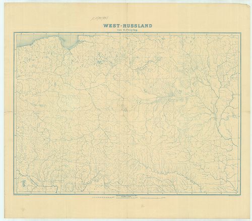
| Title | West-Russland. |
| Main title | Nyugat-Oroszország vízrajzi munkatérképe. |
257. General-Karte vom Westlichen Russland nebst Preussen, Posen ... [B XI c 56/1]
Institute and Museum of Military History •
B XI c
•
B XI Oroszország
•
B I–XV. Európa

| Title | General-Karte vom Westlichen Russland nebst Preussen, Posen und Galizien. |
| Main title | Mt.: Warschau (Varsó). |
| Subject | Nyugat-Oroszország, Poroszország, Lengyelország és Galícia általános térképe 1868-ban. |
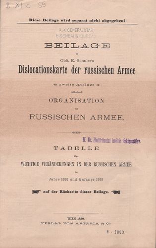
258. Dislocations-Karte der Russischen-Armee. [B XI c 57]
Institute and Museum of Military History •
B XI c
•
B XI Oroszország
•
B I–XV. Európa

| Title | Dislocations-Karte der Russischen-Armee. |
| Main title | Oroszországi hadseregek diszlokációs térképe az összegyűjtött adatok alapján 1880-ban. |
259. Dislocations Karte der Russischen Heeres (im europäischen Re... [B XI c 59]
Institute and Museum of Military History •
B XI c
•
B XI Oroszország
•
B I–XV. Európa
| Title | Dislocations Karte der Russischen Heeres (im europäischen Reichstheile) nebst Tebellarischer Übersicht der Armeeverhältnisse im Frieden, in der Mobilisirung und im Kriege. |
| Main title | Mt.: Der Militär-Bezirk Warschau (Varsó katonai területe.) |
| Subject | Az Európai Oroszország hadseregének diszlokációs térképe. |
260. Die Standquartiere des Russischen Heeres im Europaeischen Re... [B XI c 60]
Institute and Museum of Military History •
B XI c
•
B XI Oroszország
•
B I–XV. Európa

| Title | Die Standquartiere des Russischen Heeres im Europaeischen Reichstheile. |
| Main title | Mt.: Kaukasus nebst Astrachan. (Kaukázus és Astrahany) |
| Subject | Az Európai Oroszország hadseregének állomáshelyei 1890-ben a vasútvonalak mellett. |