51. Upravlenije Vojennih Topografov. [B XI a 54/3]
Institute and Museum of Military History •
B XI a
•
B XI Oroszország
•
B I–XV. Európa
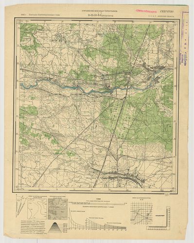
| Title | Upravlenije Vojennih Topografov. |
| Main title | Oroszország 1:25 000 ma. topográfiai térképsorozatának 3 szelvénye. |
52. [Lengyelország és Ukrajna egy része.] [B XI a 56/1]
Institute and Museum of Military History •
B XI a
•
B XI Oroszország
•
B I–XV. Európa
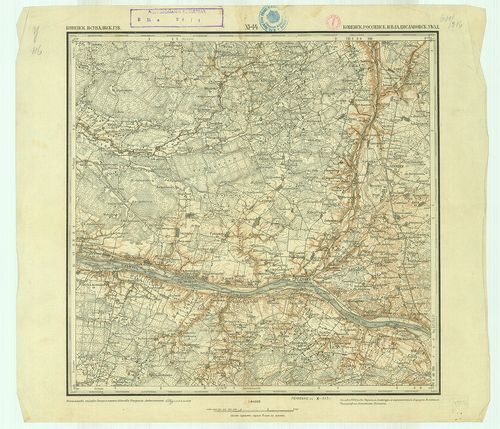
| Title | [Lengyelország és Ukrajna egy része.] |
53. Typus Generalis Ukrainae sive Palatinatuum Podoliae, Kiovens... [B XI a 56/2]
Institute and Museum of Military History •
B XI a
•
B XI Oroszország
•
B I–XV. Európa
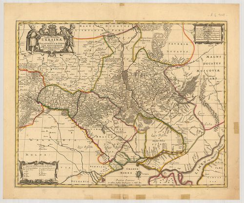
| Title | Typus Generalis Ukrainae sive Palatinatuum Podoliae, Kiovensis… |
| Main title | Ukrajna, Podolia, és a Kijev-i területek térképe 1682-ben. |
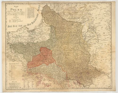
54. Amplissima Ucrainae Regio Palatinatus Kioviensem et Braclavi... [B XI a 56/3]
Institute and Museum of Military History •
B XI a
•
B XI Oroszország
•
B I–XV. Európa
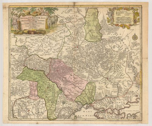
| Title | Amplissima Ucrainae Regio Palatinatus Kioviensem et Braclaviensem… |
| Main title | Ukrajna térképe 1745-ben. |
55. [Oroszország déli része.] [B XI a 57]
Institute and Museum of Military History •
B XI a
•
B XI Oroszország
•
B I–XV. Európa
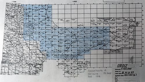
| Title | [Oroszország déli része.] |
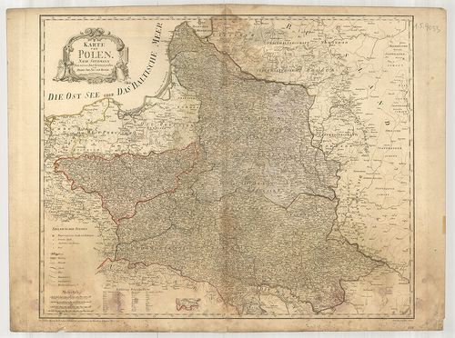
56. Mappa Geographica Regni Poloniae… Carte des Etats de la Corv... [B XI a 61]
Institute and Museum of Military History •
B XI a
•
B XI Oroszország
•
B I–XV. Európa
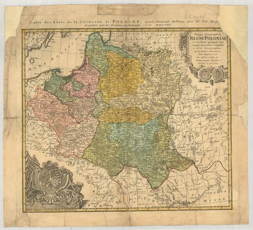
| Title | Mappa Geographica Regni Poloniae… Carte des Etats de la Corvonne de Pologne. |
| Main title | Lengyelország általános térképe 1757-ben. |
57. Carte générale et nouvelle detoutte la Pologne du Grand Duch... [B XI a 62]
Institute and Museum of Military History •
B XI a
•
B XI Oroszország
•
B I–XV. Európa
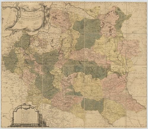
| Title | Carte générale et nouvelle detoutte la Pologne du Grand Duche de Lithuanie et des Pais Limitrofes. |
| Main title | Lengyelország és a Litván nagyhercegség általános térképe 1770-ben. |
58. Mappa Geographica Ploniae… [B XI a 62/1]
Institute and Museum of Military History •
B XI a
•
B XI Oroszország
•
B I–XV. Európa
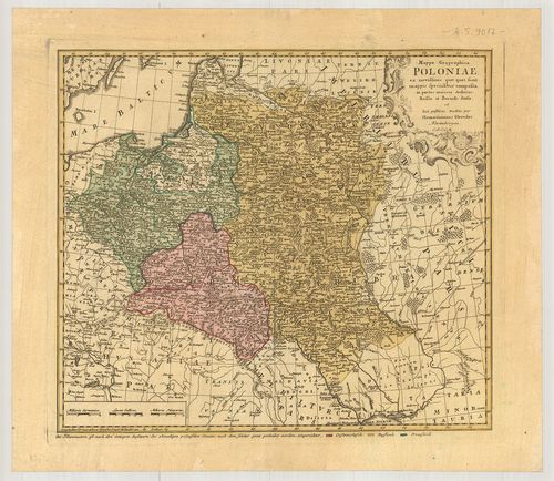
| Title | Mappa Geographica Ploniae… |
| Main title | Lengyelország földrajzi térképe 1750 körül. |
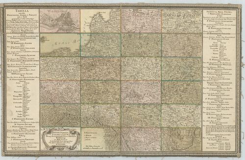
59. Die Königliche Republik Polen mit Grossherzoghtum Lithauen. ... [B XI a 63]
Institute and Museum of Military History •
B XI a
•
B XI Oroszország
•
B I–XV. Európa
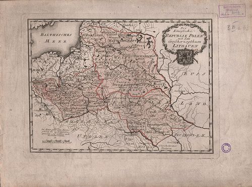
| Title | Die Königliche Republik Polen mit Grossherzoghtum Lithauen. Nro. 38. |
| Main title | Lengyelország és a Litván nagyhercegség térképe 1789-ben. |
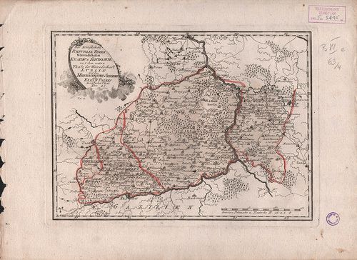
60. Der Königlichen Republik Polen Woidwedschaften Posen, Kalisz... [B XI a 63/1]
Institute and Museum of Military History •
B XI a
•
B XI Oroszország
•
B I–XV. Európa
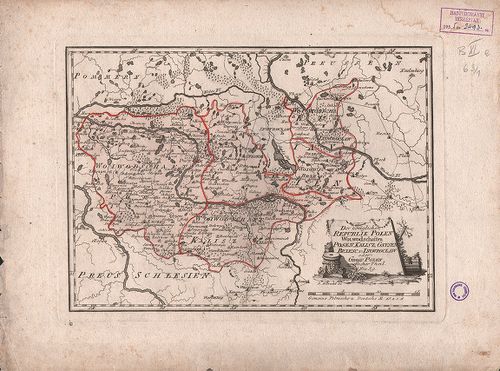
| Title | Der Königlichen Republik Polen Woidwedschaften Posen, Kalisz Gmesen, Brzese und Inowroclaw. No. 39. |
| Main title | Lengyelország vajdaságai 1789-ben. |
61. Der Königlichen Republik Polen Woiwodschaften Sieradz, Lents... [B XI a 63/2]
Institute and Museum of Military History •
B XI a
•
B XI Oroszország
•
B I–XV. Európa
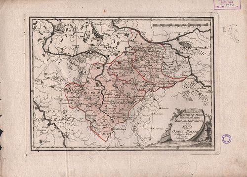
| Title | Der Königlichen Republik Polen Woiwodschaften Sieradz, Lentschitz und Rawa. Nro. 40. |
| Main title | Lengyelország vajdaságai 1789-ben. |
62. Der Königlichen Republik Polen Woiwodschaften Plotzk und Mas... [B XI a 63/3]
Institute and Museum of Military History •
B XI a
•
B XI Oroszország
•
B I–XV. Európa
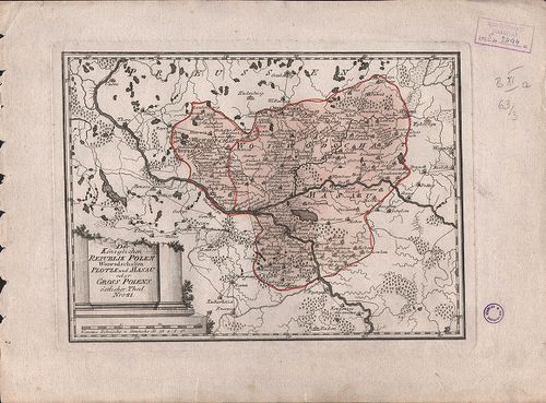
| Title | Der Königlichen Republik Polen Woiwodschaften Plotzk und Masau. Nro. 41. |
| Main title | Lengyelország vajdaságai 1789-ben. |
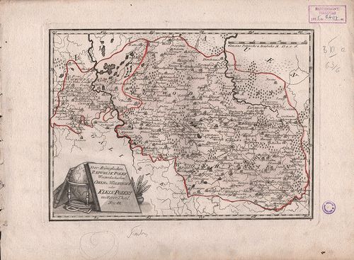
63. Der Königlichen Republik Polen Woiwodschaften Krakow und San... [B XI a 63/4]
Institute and Museum of Military History •
B XI a
•
B XI Oroszország
•
B I–XV. Európa
| Title | Der Königlichen Republik Polen Woiwodschaften Krakow und Sandomir mit… Lublin. Nro. 42. |
| Main title | Lengyelország vajdaságai 1789-ben. |
64. Der Königlichen Republik Polen Woiwodschaft Podlachien mit… ... [B XI a 63/5]
Institute and Museum of Military History •
B XI a
•
B XI Oroszország
•
B I–XV. Európa
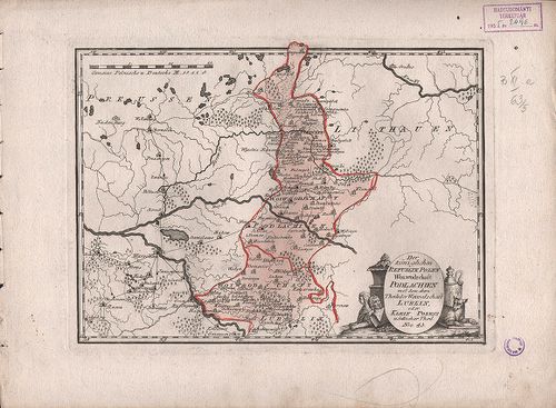
| Title | Der Königlichen Republik Polen Woiwodschaft Podlachien mit… Lublin. Nro. 43. |
| Main title | Lengyelország vajdaságai 1789-ben. |
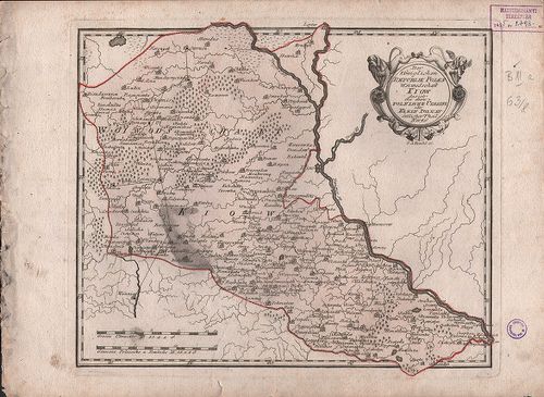
65. Der Königlichen Republik Polen. Woiwodschaften Chelm und Wol... [B XI a 63/6]
Institute and Museum of Military History •
B XI a
•
B XI Oroszország
•
B I–XV. Európa
| Title | Der Königlichen Republik Polen. Woiwodschaften Chelm und Wolhynien. Nro. 44. |
| Main title | Lengyelország vajdaságai 1789-ben. |
66. Der Königlichen Republik Polen. Woiwodschaft Kiew. Nro. 46. [B XI a 63/8]
Institute and Museum of Military History •
B XI a
•
B XI Oroszország
•
B I–XV. Európa
| Title | Der Königlichen Republik Polen. Woiwodschaft Kiew. Nro. 46. |
| Main title | Lengyelország Kijevi vajdasága 1789-ben. |
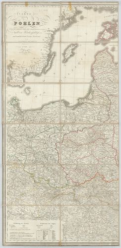
67. Carte de la Pologne… [B XI a 64]
Institute and Museum of Military History •
B XI a
•
B XI Oroszország
•
B I–XV. Európa
| Title | Carte de la Pologne… |
| Main title | Mt.: Plan de Varsovie (Varsó). |
| Subject | Lengyelország térképe 1772-ben tartományi beosztással. |
68. Karte von Gross Polen… [B XI a 65]
Institute and Museum of Military History •
B XI a
•
B XI Oroszország
•
B I–XV. Európa
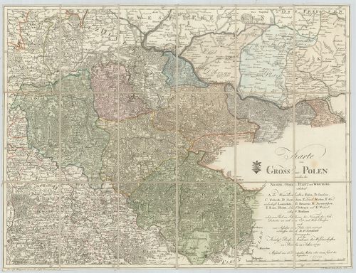
| Title | Karte von Gross Polen… |
| Main title | Lengyelország térképe 1791-ben. |
69. Polen in die dermaligen Besitzungen eingetheilt. [B XI a 66]
Institute and Museum of Military History •
B XI a
•
B XI Oroszország
•
B I–XV. Európa
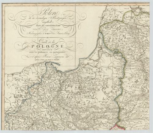
| Title | Polen in die dermaligen Besitzungen eingetheilt. |
| Main title | Lengyelország általános térképe a 2. felosztás után 1807-ben a vajdaságok feltüntetésével. |
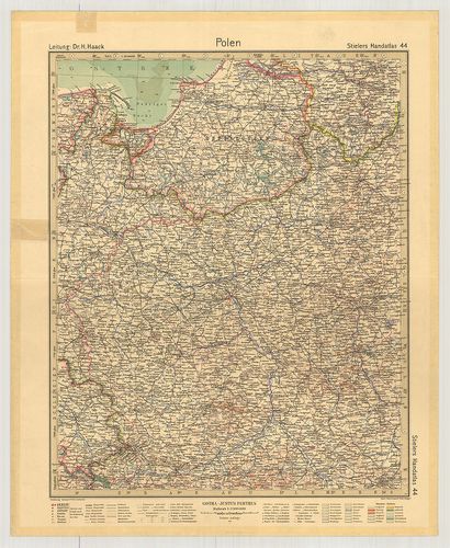
70. Polen. (Rzeczpospolita Polska) Flemmings Generalkarte. Nr. 3... [B XI a 68]
Institute and Museum of Military History •
B XI a
•
B XI Oroszország
•
B I–XV. Európa
| Title | Polen. (Rzeczpospolita Polska) Flemmings Generalkarte. Nr. 33. |
| Main title | 11 mt.: 1. (5) Reisewege von und nach Polen. (Vasút, repülő-hajózási útvonalak Európa területén.) 2. (6) Polen. (Lengyelország hegyvízrajzi térképe.) 3. (7) Warschau und Umgebung (Warszawa és környéke.) 4. (9) Das oberschlesische Kohlen- und Industriegebiet (Felső-Szilézia kőszén és iparvidéke.) 5. Oberschles. Steinkohlengebiet. (Felső-Szilézia kőszénvidéke.) 6. (10) Niederschläge (Az évi csapadék.) 7. (11) Január-Isothermen (Januári izotermák.) 8. (12) Juli-Isothermen (Júliusi izotermák.) 9. (13) Zur Geschichte Polens I. (Lengyelország 992–1025.) 10. (14) Zur Geschichte Polens II. (Lengyelország 1586.) 11. (15) Zur Geschichte Polen III. (Lengyelország 1772., 1793., 1795. évi felosztása.) |
| Subject | Lengyelország térképe 1922-ben. |
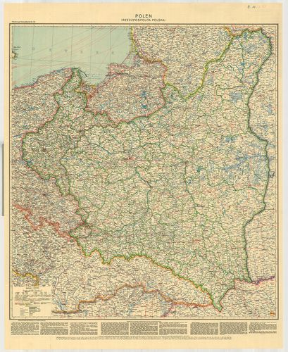
71. Polen. [B XI a 69]
Institute and Museum of Military History •
B XI a
•
B XI Oroszország
•
B I–XV. Európa
| Title | Polen. |
| Main title | Lengyelország térképe 1931-ben. |
72. Karte von Polen… 1795. [B XI a 73]
Institute and Museum of Military History •
B XI a
•
B XI Oroszország
•
B I–XV. Európa
| Title | Karte von Polen… 1795. |
| Main title | Lengyelország térképe 1795-ben. |
73. Karte von Polen. [B XI a 73/1]
Institute and Museum of Military History •
B XI a
•
B XI Oroszország
•
B I–XV. Európa
| Title | Karte von Polen. |
| Main title | Lengyelország térképe 1796-ban. |
74. Carte von Polen… der angrenzenden Laender. – Carte Générale ... [B XI a 74]
Institute and Museum of Military History •
B XI a
•
B XI Oroszország
•
B I–XV. Európa
| Title | Carte von Polen… der angrenzenden Laender. – Carte Générale et détaillée de la Pologne… |
| Main title | Lengyelország térképe 1828-ban. |
75. Karte von Herzogthum Warschau… in IV. Section. [B XI a 74/1]
Institute and Museum of Military History •
B XI a
•
B XI Oroszország
•
B I–XV. Európa
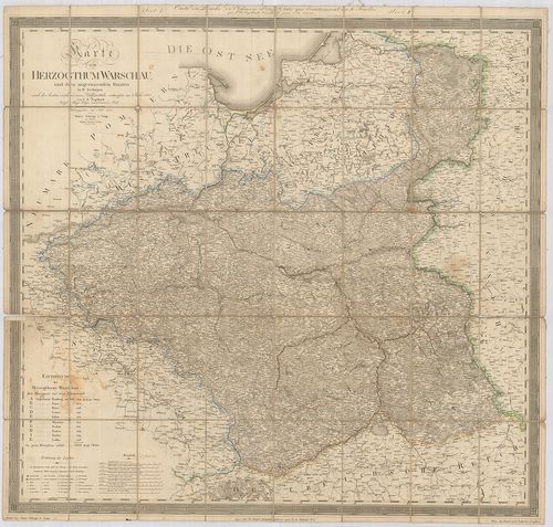
| Title | Karte von Herzogthum Warschau… in IV. Section. |
| Main title | A Varsói Hercegség és a szomszédos területek térképe 1812-ben. |
76. Carte de la Pologne et de la Partie de la Russie D’Europe. [B XI a 75]
Institute and Museum of Military History •
B XI a
•
B XI Oroszország
•
B I–XV. Európa

| Title | Carte de la Pologne et de la Partie de la Russie D’Europe. |
| Main title | Lengyelország, valamint az Európai Oroszország egy részének általános térképe 1812-ben. |
77. Carte du Royaume de Pologne. – Carte des vormaligen ganzen K... [B XI a 76]
Institute and Museum of Military History •
B XI a
•
B XI Oroszország
•
B I–XV. Európa
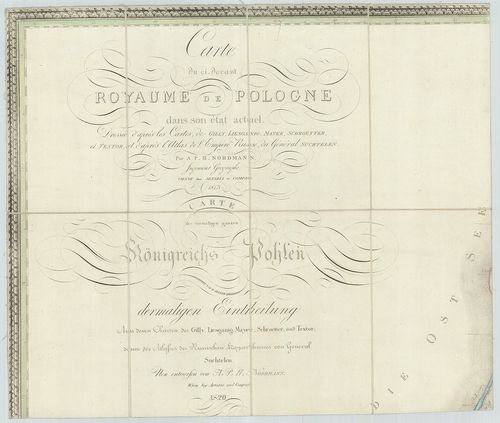
| Title | Carte du Royaume de Pologne. – Carte des vormaligen ganzen Königreichs Pohlen… |
| Main title | Lengyelország térképe 1820-ban a 3. felosztás után. |
78. Carte du Royaume de Pologne. – Königreich Poheln. [B XI a 80]
Institute and Museum of Military History •
B XI a
•
B XI Oroszország
•
B I–XV. Európa
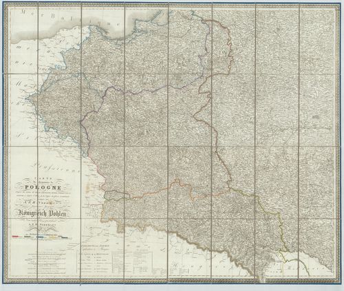
| Title | Carte du Royaume de Pologne. – Königreich Poheln. |
| Main title | A Lengyel Királyság térképe 1831-ben. |
79. Karte des Königreiches Polen. [B XI a 84]
Institute and Museum of Military History •
B XI a
•
B XI Oroszország
•
B I–XV. Európa
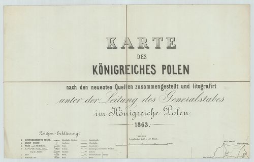
| Title | Karte des Königreiches Polen. |
| Main title | A Lengyel Királyság térképe 1863-ban. |
80. Karta Carsztva Polszkago. [B XI a 88]
Institute and Museum of Military History •
B XI a
•
B XI Oroszország
•
B I–XV. Európa
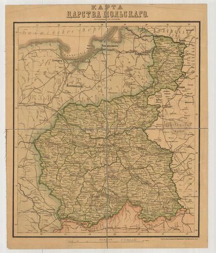
| Title | Karta Carsztva Polszkago. |
| Main title | A cári Lengyelország térképe 1890-ben. |
81. Karta Dawnéj Polski z przýległémi okolicani krajów sasiednic... [B XI a 91]
Institute and Museum of Military History •
B XI a
•
B XI Oroszország
•
B I–XV. Európa
| Title | Karta Dawnéj Polski z przýległémi okolicani krajów sasiednich… |
| Main title | Lengyelország és a szomszédos területek, Oroszország nyugati részének térképe 1859-ben. |
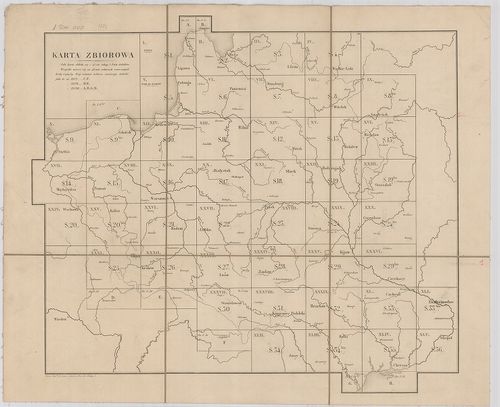
82. Topograficseszkaja karta Carsztva Polszkago. [B XI a 94]
Institute and Museum of Military History •
B XI a
•
B XI Oroszország
•
B I–XV. Európa
| Title | Topograficseszkaja karta Carsztva Polszkago. |
| Main title | A cári Lengyelország topográfiai térképe 1839-ben. |
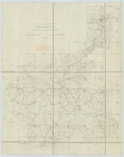
83. [Krakkó – Lvov és Bucsács köötti területek térképe.] [B XI a 94/1]
Institute and Museum of Military History •
B XI a
•
B XI Oroszország
•
B I–XV. Európa
| Title | [Krakkó – Lvov és Bucsács köötti területek térképe.] |
84. Westrussland, Südlicher Teil. 135–136. [B XI a 94/2]
Institute and Museum of Military History •
B XI a
•
B XI Oroszország
•
B I–XV. Európa
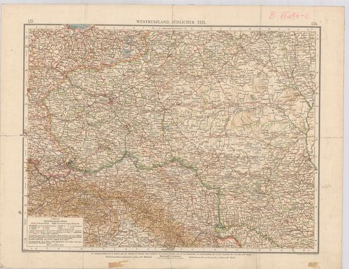
| Title | Westrussland, Südlicher Teil. 135–136. |
| Main title | Nyugat-Oroszország déli részének térképe. |
85. Westrussland. Freytag–Berndt: Handkarten. [B XI a 94/3]
Institute and Museum of Military History •
B XI a
•
B XI Oroszország
•
B I–XV. Európa
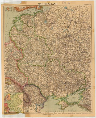
| Title | Westrussland. Freytag–Berndt: Handkarten. |
| Main title | Mt.: Europäisches Russland. (Az Európai Oroszország.) |
| Subject | Nyugat-Oroszország térképe 1942-ben. |
86. West und Inner-Russland. [B XI a 95/1]
Institute and Museum of Military History •
B XI a
•
B XI Oroszország
•
B I–XV. Európa
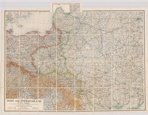
| Title | West und Inner-Russland. |
| Main title | 7 mt.: 1. St. Petersburg (Leningrád). 2. Warschau (Varsó). 3. Reval (Tallin). 4. Odessa (Odessza). 5. Moskau (Moszkva). 6. Kiew (Kijev). 7. Die Ostseeländer (Keleti-tenger országai). |
| Subject | Nyugat- és Közép-Oroszország térképe 1915-ben a vasútvonalak feltüntetésével. |
87. Westpolen. [B XI a 95/2]
Institute and Museum of Military History •
B XI a
•
B XI Oroszország
•
B I–XV. Európa
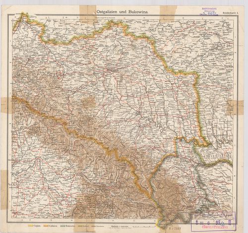
| Title | Westpolen. |
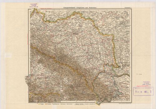
| Main title | Ostgalizien und Bukovina. (Kelet-Galícia és Bukovina). |
| Subject | Nyugat-Lengyelország térképe 1900 körül. |
88. Polen. [B XI a 95/3]
Institute and Museum of Military History •
B XI a
•
B XI Oroszország
•
B I–XV. Európa
| Title | Polen. |
| Main title | Karpatenland (Ostgalizien und Bukovina.) (Kelet-Galícia és Bukovina). |
| Subject | Lengyelország térképe 1900 körül. |
89. Westliches Russland mit den deutschen österreichisch–ungaris... [B XI a 95/4]
Institute and Museum of Military History •
B XI a
•
B XI Oroszország
•
B I–XV. Európa
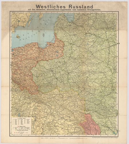
| Title | Westliches Russland mit den deutschen österreichisch–ungarischen und russischen Grenzgebiet. |
| Main title | Nyugat-Oroszország, a német és az osztrák–magyar határvidék közigazgatási térképe 1900 körül. |
90. Hölzel’s Handkarte von West-Russland. [B XI a 97]
Institute and Museum of Military History •
B XI a
•
B XI Oroszország
•
B I–XV. Európa
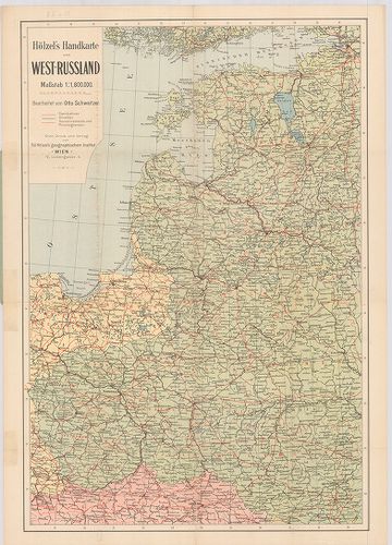
| Title | Hölzel’s Handkarte von West-Russland. |
| Main title | Nyugat-Oroszország térképe a vasútvonalak feltüntetésével. |
91. Mapa Ziem Polskich. [B XI a 99]
Institute and Museum of Military History •
B XI a
•
B XI Oroszország
•
B I–XV. Európa
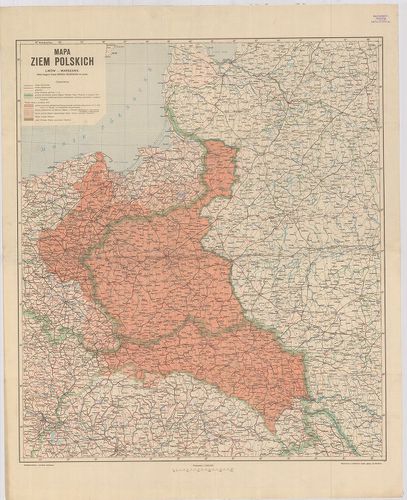
| Title | Mapa Ziem Polskich. |
| Main title | Lengyelország térképe 1919-ben. |
92. General-Karte der Krymm. [B XI a 100]
Institute and Museum of Military History •
B XI a
•
B XI Oroszország
•
B I–XV. Európa
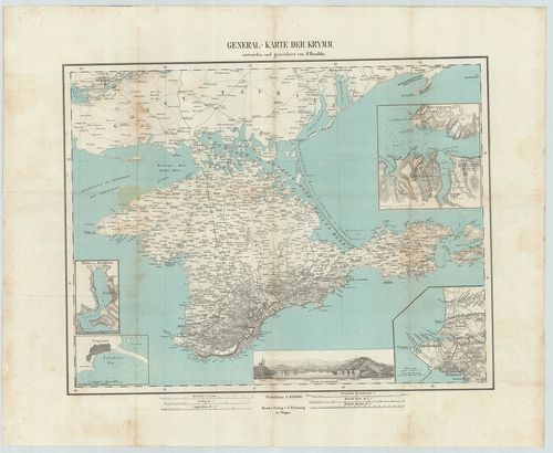
| Title | General-Karte der Krymm. |
| Main title | 4 mt.: 1. Hafen von Balaklawa. (A Balaklava kikötő) 2. Ewpatoria [Jevpatorija erődítmény.] 3. [Szevasztopol és környéke.] 4. [Szevasztopol és az erődítmény alaprajza.] |
| Subject | A Krim-félsziget általános térképe 1855-ben. |
93. West-Galizien. I.–II.–III. Blatt. – de la Galicie Occidental... [B XI a 101]
Institute and Museum of Military History •
B XI a
•
B XI Oroszország
•
B I–XV. Európa
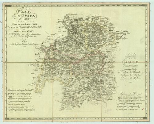
| Title | West-Galizien. I.–II.–III. Blatt. – de la Galicie Occidentale. |
| Main title | Nyugat-Galícia részletes térképe megbízható forrásmunkák alapján 1803-ban. |
94. G. Freytags Karte der Ukraina. [B XI a 102]
Institute and Museum of Military History •
B XI a
•
B XI Oroszország
•
B I–XV. Európa
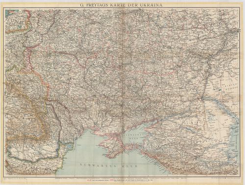
| Title | G. Freytags Karte der Ukraina. |
| Main title | Ukrajna térképe a kormányzósági határokkal (1918. március 4-i breszti béke határai). |
95. Deutsch–Russischen Kriegsschauplatzes [B XI a 103]
Institute and Museum of Military History •
B XI a
•
B XI Oroszország
•
B I–XV. Európa
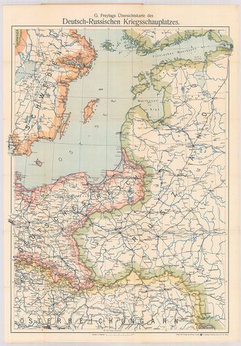
| Title | Deutsch–Russischen Kriegsschauplatzes |
| Main title | A német–orosz hadszíntér térképe 1914 után. |
96. Topographisch Militaerisch Karte vom vormaligen… Ost Preusse... [B XI a 105/2]
Institute and Museum of Military History •
B XI a
•
B XI Oroszország
•
B I–XV. Európa
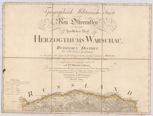
| Title | Topographisch Militaerisch Karte vom vormaligen… Ost Preussen oder dem jetzigen Nördlichen. Theil Herzogthums Warschau. |
| Main title | Kelet-Poroszország és a Varsói hercegség katonai térképe 1808-ban. |
97. Neu Ostpreussen. [B XI a 105/3]
Institute and Museum of Military History •
B XI a
•
B XI Oroszország
•
B I–XV. Európa
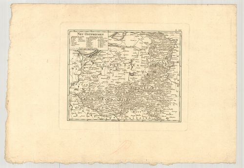
| Title | Neu Ostpreussen. |
| Main title | Kelet-Poroszország térképe a 19. század elején. |
98. Carte de la partie méridionale du grand duché de Varsovie. [B XI a 106]
Institute and Museum of Military History •
B XI a
•
B XI Oroszország
•
B I–XV. Európa
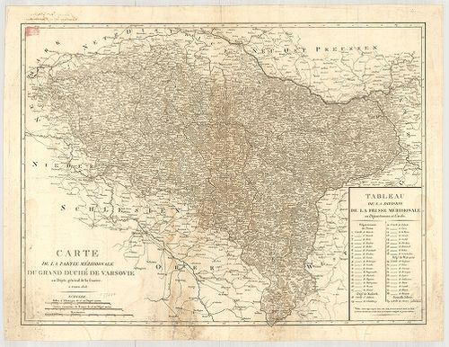
| Title | Carte de la partie méridionale du grand duché de Varsovie. |
| Main title | A Varsói Nagyhercegség általános katonai térképe 1808-ban. |
99. Karte von West-Gallizien. [B XI a 107]
Institute and Museum of Military History •
B XI a
•
B XI Oroszország
•
B I–XV. Európa
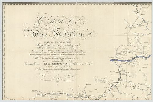
| Title | Karte von West-Gallizien. |
| Main title | Nyugat-Galícia térképe 1808-ban. |
100. General-Carte von Westgallizien. [B XI a 108]
Institute and Museum of Military History •
B XI a
•
B XI Oroszország
•
B I–XV. Európa
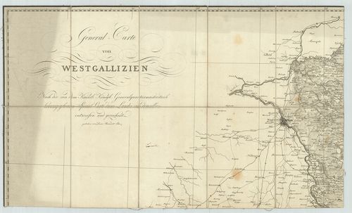
| Title | General-Carte von Westgallizien. |
| Main title | Nyugat-Galícia általános térképe. |