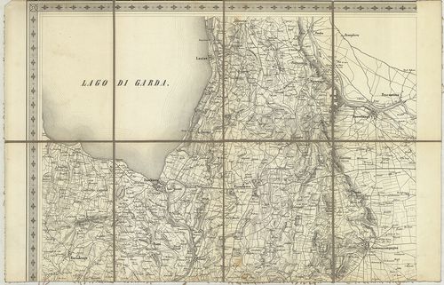
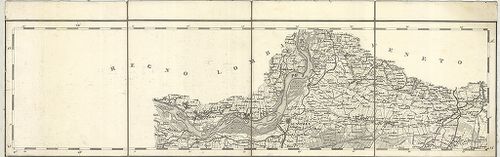
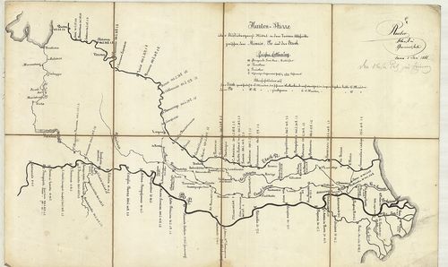
101. Manoeuvre-Terrain am Mincio. Detailkarte des Landestriches z... [B VII a 195]
Institute and Museum of Military History •
B VII a
•
B VII Olaszország
•
B I–XV. Európa
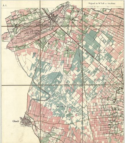
| Title | Manoeuvre-Terrain am Mincio. Detailkarte des Landestriches zwischen Brescia, Verona u. Illasi. |
| Main title | Mincio melletti hadgyakorlati terület térképe, Brescia, Verona és Illasi között 1840–41-ben. |
102. Manövre Terrain am Mincio, reambulirten Detailkarte. [B VII a 195/1]
Institute and Museum of Military History •
B VII a
•
B VII Olaszország
•
B I–XV. Európa
| Title | Manövre Terrain am Mincio, reambulirten Detailkarte. |
| Main title | Mincio melletti hadgyakorlati terület térképe Brescia, Verona és Illasti között 1859-ben. |
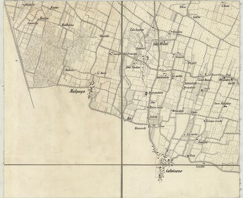
103. Plan des Manövrir-Terrains naechts Monselice. [B VII a 195/2]
Institute and Museum of Military History •
B VII a
•
B VII Olaszország
•
B I–XV. Európa
| Title | Plan des Manövrir-Terrains naechts Monselice. |
| Main title | A Monselice melletti gyakorlótértérképe a 19. század végén. |
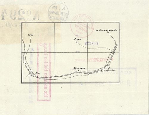
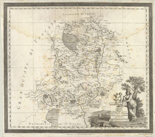
104. [Északkelet-Olaszország: a Rigolato-Pontebba-Tarvisio és Tol... [B VII a 200/5]
Institute and Museum of Military History •
B VII a
•
B VII Olaszország
•
B I–XV. Európa
| Title | [Északkelet-Olaszország: a Rigolato-Pontebba-Tarvisio és Tolmezzo-Gemona közti terület általános térképe.] |
105. Gegend zwischen Verona, Peschiera und Mantova. [B VII a 202]
Institute and Museum of Military History •
B VII a
•
B VII Olaszország
•
B I–XV. Európa
| Title | Gegend zwischen Verona, Peschiera und Mantova. |
| Main title | Verona, Peschiera és Mantova közti terület térképe a 19. század közepén. |
106. Nuova Carta Corografica, o sia centro del gran teatro di gue... [B VII a 212]
Institute and Museum of Military History •
B VII a
•
B VII Olaszország
•
B I–XV. Európa
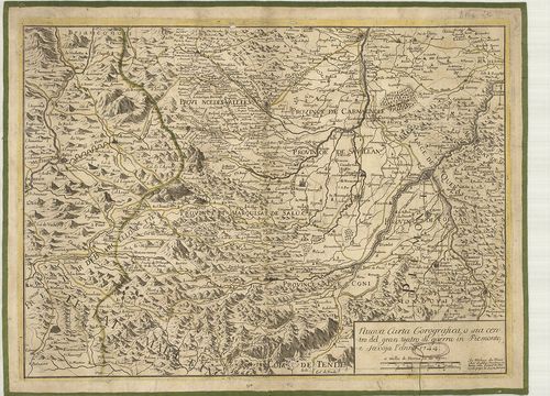
| Title | Nuova Carta Corografica, o sia centro del gran teatro di guerra in Piemonte, e Savoya. |
| Main title | Piemonte és Savoja tartomány földrajzi térképe 1744-ben. |
107. Piemonte diviso in quattro dipartiment [B VII a 213]
Institute and Museum of Military History •
B VII a
•
B VII Olaszország
•
B I–XV. Európa
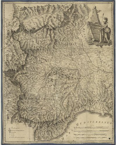
| Title | Piemonte diviso in quattro dipartiment |
| Main title | Piemonte tartomány térképe négy kerületre osztva 1799-ben. |
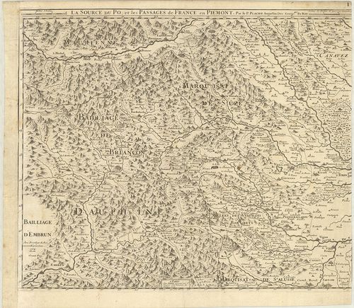
108. Carte des Vallées d’Oulx Exille Chaumont etc. Suse et de Pra... [B VII a 218]
Institute and Museum of Military History •
B VII a
•
B VII Olaszország
•
B I–XV. Európa
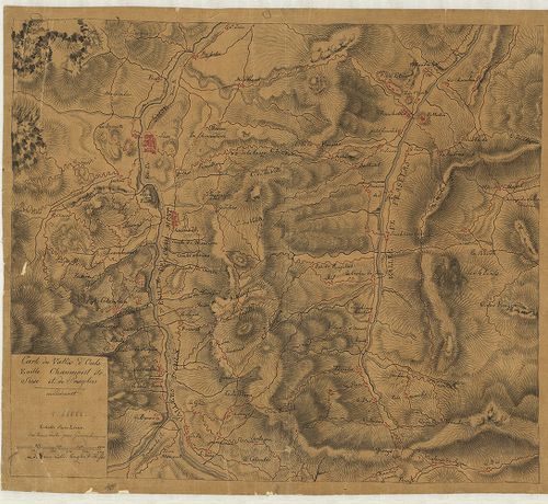
| Title | Carte des Vallées d’Oulx Exille Chaumont etc. Suse et de Pragelas en Piedmont. |
| Main title | Piemonte tartomány (Susa-Exilles-Ulzip-Pragetato környékének) térképe a 18. században. |
109. Carta de la Rivera de Genova con sus Verdaderos Confines y C... [B VII a 261]
Institute and Museum of Military History •
B VII a
•
B VII Olaszország
•
B I–XV. Európa
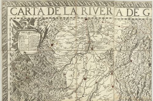
| Title | Carta de la Rivera de Genova con sus Verdaderos Confines y Caminos. – Topographia de la Liguria… |
| Main title | Liguria tartomány térképe 1685-ben. |
110. Karte von der Republik Genua. [B VII a 264]
Institute and Museum of Military History •
B VII a
•
B VII Olaszország
•
B I–XV. Európa
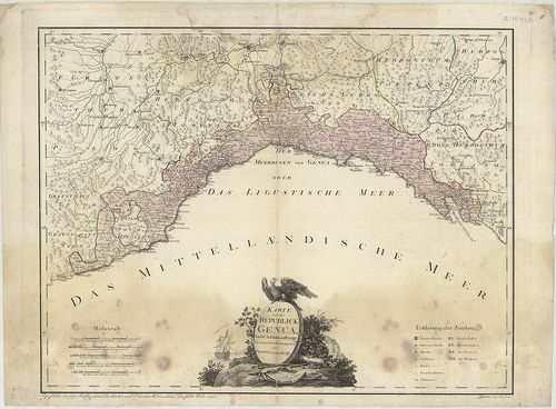
| Title | Karte von der Republik Genua. |
| Main title | A Genovai Köztársaság térképe 1796-ban. |
111. Carta topografica degli stati della Republica di Genova, sec... [B VII a 265]
Institute and Museum of Military History •
B VII a
•
B VII Olaszország
•
B I–XV. Európa
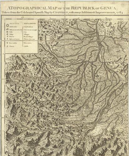
| Title | Carta topografica degli stati della Republica di Genova, secondo l’Originale del famoso Chaffrion con molte aumentazioni e Correzioni, 1784. – A topographical map of the Republick of Genua. – Carte topographique des Etats de la Republique de Genes. – Topographische charte sämbtlichen Länder, der Republic Genua. |
| Main title | 3 mt.: 1. Carte de l’Isle de Corse… (Korzika). 2. Carte de l’Isle de Sardaigne (Szardinia). 3. Isola di Caprara(Capraia-sz.). |
| Subject | A Genovai Köztársaság topográfiai térképe 1784-ben. |
112. Stato della Republica di Lucca. [B VII a 271]
Institute and Museum of Military History •
B VII a
•
B VII Olaszország
•
B I–XV. Európa
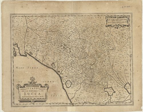
| Title | Stato della Republica di Lucca. |
| Main title | Lucca tartomány térképe 1642-ben. |
113. Legazione di Bologna. [B VII a 277]
Institute and Museum of Military History •
B VII a
•
B VII Olaszország
•
B I–XV. Európa
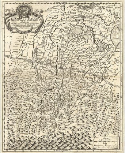
| Title | Legazione di Bologna. |
| Main title | Bologna tartomány térképe 1710-ben. |
114. Pianta del Dipartimento del Reno… [B VII a 279/2]
Institute and Museum of Military History •
B VII a
•
B VII Olaszország
•
B I–XV. Európa
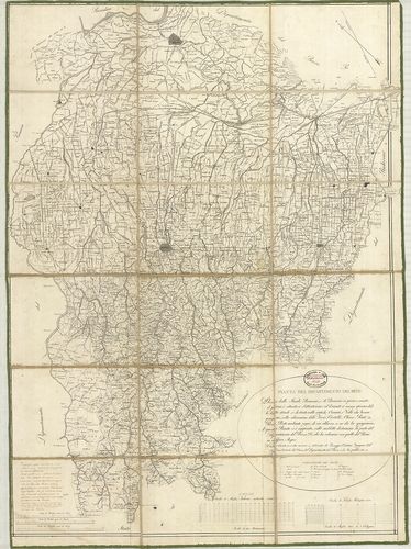
| Title | Pianta del Dipartimento del Reno… |
| Main title | Reno körzetének - Bologna és környéke térképe 1810 körül. |
115. Corografia del Ducato di Ferrara… 1758. [B VII a 284]
Institute and Museum of Military History •
B VII a
•
B VII Olaszország
•
B I–XV. Európa
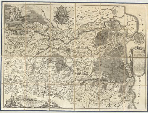
| Title | Corografia del Ducato di Ferrara… 1758. |
| Main title | Ferrara hercegség földrajzi térképe 1758–1782-ben. |
116. Gran Ducato di Toscana stato vecchio o dominio Fiorentina, s... [B VII a 284/2]
Institute and Museum of Military History •
B VII a
•
B VII Olaszország
•
B I–XV. Európa
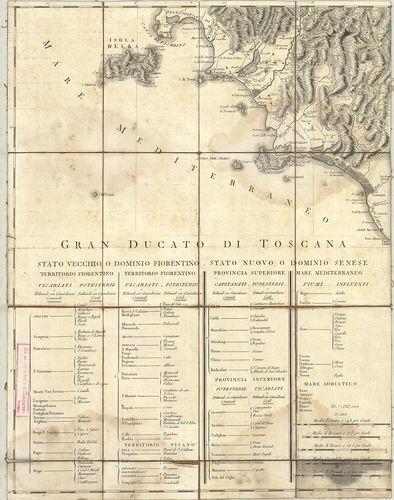
| Title | Gran Ducato di Toscana stato vecchio o dominio Fiorentina, stato nuova, o dominio senese. |
| Main title | A Toscana-i Nagyhercegség térképe 1730–40 körül. |
117. Topografia della Provincia Ferrarese della Pianura Bolognese... [B VII a 285]
Institute and Museum of Military History •
B VII a
•
B VII Olaszország
•
B I–XV. Európa
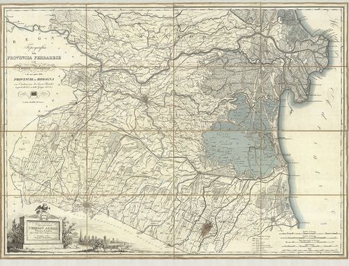
| Title | Topografia della Provincia Ferrarese della Pianura Bolognese e di una parte delle Provincie di Romagna con l’indicazione dei lavori Idraulici eseguiti dal 1767 a tutto Giugno del 1825. |
| Main title | Ferrara tartomány a Bolognai-síkság és a Romagna tartomány egy részének térképe 1825-ben. |
118. Legatione della Romagna. [B VII a 285/1]
Institute and Museum of Military History •
B VII a
•
B VII Olaszország
•
B I–XV. Európa
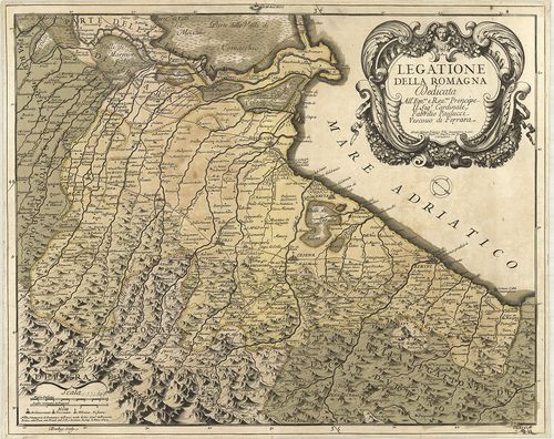
| Title | Legatione della Romagna. |
| Main title | Romagna tartomány térképe 1699-ben. |
119. Territorivm Bononiense il Bolognese. [B VII a 306]
Institute and Museum of Military History •
B VII a
•
B VII Olaszország
•
B I–XV. Európa
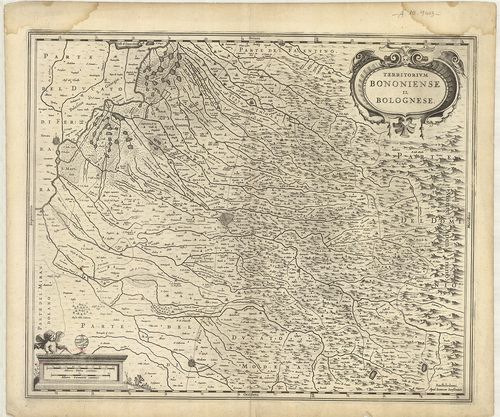
| Title | Territorivm Bononiense il Bolognese. |
| Main title | Bologna tartomány térképe 1642-ben. |
120. Carta topografica del Ducato di Modena… [B VII a 313]
Institute and Museum of Military History •
B VII a
•
B VII Olaszország
•
B I–XV. Európa
| Title | Carta topografica del Ducato di Modena… |
| Main title | Modena hercegség topográfiai térképe 1842-ben. |
121. Carta topografica del Ducato di Modena… [B VII a 314]
Institute and Museum of Military History •
B VII a
•
B VII Olaszország
•
B I–XV. Európa
| Title | Carta topografica del Ducato di Modena… |
| Main title | Modena hercegség topográfiai térképe 1849-ben. |
122. Status Parmanensis sive Dvcatvs Parmanensis et Placentinus u... [B VII a 316]
Institute and Museum of Military History •
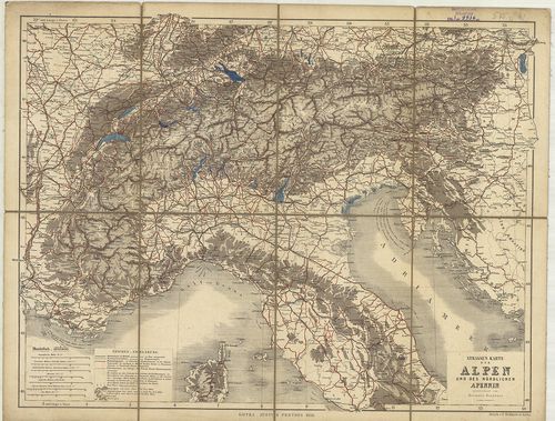
B VII a
•
B VII Olaszország
•
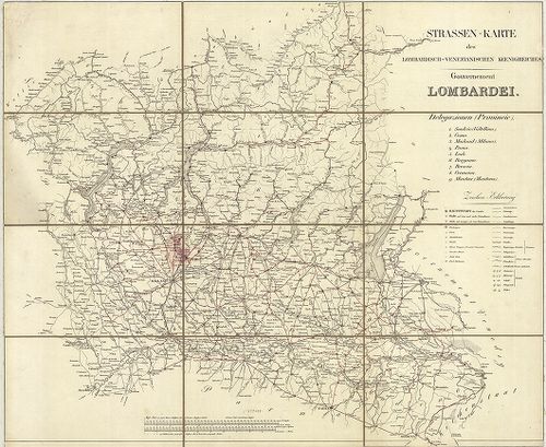
B I–XV. Európa
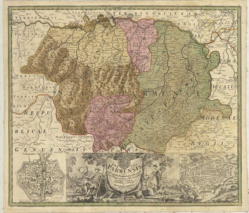
| Title | Status Parmanensis sive Dvcatvs Parmanensis et Placentinus una cum Ditione Bvxetana et Valle Tarae. |
| Main title | 2 mt.: 1. Ichnographia urbis Parmae. (Parma várostérképe.) 2. Ichnographia urbis Placentiae. (Piacenza várostérképe.) |
| Subject | Parma hercegség és Piacenza hercegség térképe 1731-ben. |
123. Carta topografica degli Stati di Parma. [B VII a 318]
Institute and Museum of Military History •
B VII a
•
B VII Olaszország
•
B I–XV. Európa
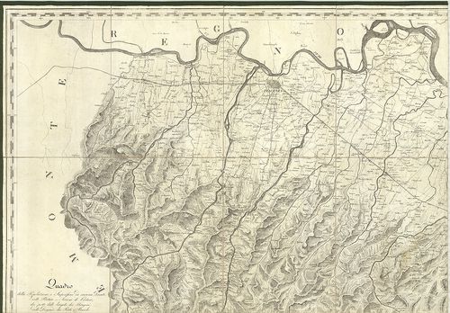
| Title | Carta topografica degli Stati di Parma. |
| Main title | Parma hercegség topográfiai térképe 1820–1823-ban. |
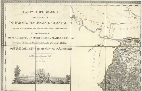
124. Carta topografica dei ducati di Parma, Piacenza e Guastalla ... [B VII a 319]
Institute and Museum of Military History •
B VII a
•
B VII Olaszország
•
B I–XV. Európa
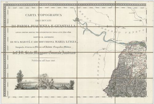
| Title | Carta topografica dei ducati di Parma, Piacenza e Guastalla levata dietro misure trigonometriche negli anni 1821–1822… |
| Main title | 2 mt.: 1. Villa ducale di Sala detta Casino di Boschi. 2. Villa e parco ducale di Colorno. |
| Subject | Parma, Piacenza és Guastalla hercegség topográfiai térképe 1828-ban. |
125. Carta topografica dei ducati di Parma, Piacenza e Guastalla ... [B VII a 321]
Institute and Museum of Military History •
B VII a
•
B VII Olaszország
•
B I–XV. Európa
| Title | Carta topografica dei ducati di Parma, Piacenza e Guastalla levata dietro misure trigonometriche negli anni 1821–1822… |
| Main title | 2 mt.: 1. Villa ducale di Sala detta Casino di Boschi. 2. Villa e parco ducale di Colorno. |
| Subject | Parma Piacenza és Guastalla hercegségek általános térképe 1849-ben. |
126. Carta Corografica dei Ducati di Parma, Piacenza e Guastalla… [B VII a 322]
Institute and Museum of Military History •
B VII a
•
B VII Olaszország
•
B I–XV. Európa
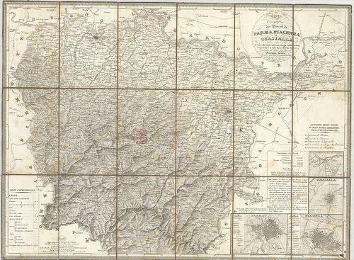
| Title | Carta Corografica dei Ducati di Parma, Piacenza e Guastalla… |
| Main title | 4 mt.: 1. Parma, 2. Piacenza, 3. Guastalla, 4. Villa e Parco Ducale di Colorno. |
| Subject | Parma, Piacenze és Guastalla hercegségek topográfiai térképe 1831 körül. |
127. Carta Generale del Grandvcato di Toscana… [B VII a 330]
Institute and Museum of Military History •
B VII a
•
B VII Olaszország
•
B I–XV. Európa
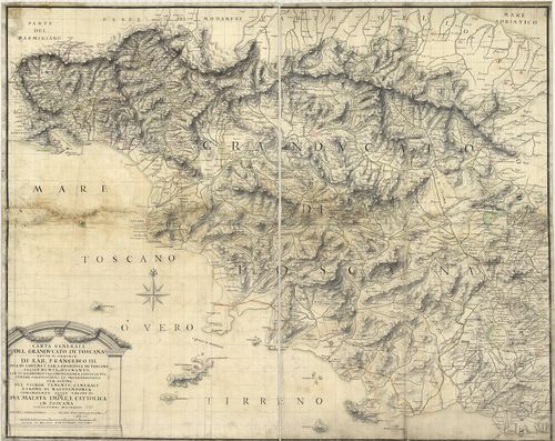
| Title | Carta Generale del Grandvcato di Toscana… |
| Main title | A Toscana-i Nagyhercegség általános térképe 1738-ban. |
128. Carta Geometrica della Toscana… [B VII a 331]
Institute and Museum of Military History •
B VII a
•
B VII Olaszország
•
B I–XV. Európa
| Title | Carta Geometrica della Toscana… |
| Main title | A Toscana-i Nagyhercegség térképe 1830-ban. |
129. Carta Corografica della Toscana e del Ducato di Lucca. [B VII a 333]
Institute and Museum of Military History •
B VII a
•
B VII Olaszország
•
B I–XV. Európa
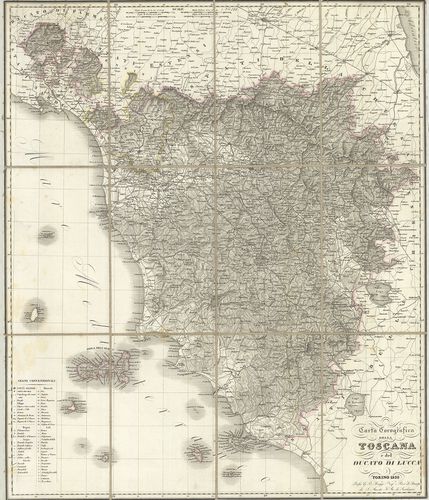
| Title | Carta Corografica della Toscana e del Ducato di Lucca. |
| Main title | A Toscana-i Nagyhercegség és Lucca hercegség topográfiai térképe 1838-ban. |
130. Carte de L’Isle d’Elbe. [B VII a 341]
Institute and Museum of Military History •
B VII a
•
B VII Olaszország
•
B I–XV. Európa
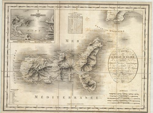
| Title | Carte de L’Isle d’Elbe. |
| Main title | Mt.: Porto Ferrajo. (Portoferraio.) |
| Subject | Elba sziget térképe 1814-ben. |
131. Carte Topographique del’ Archipel Toscanou de L’Ile D’Elbe e... [B VII a 342]
Institute and Museum of Military History •
B VII a
•
B VII Olaszország
•
B I–XV. Európa
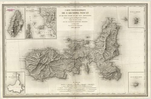
| Title | Carte Topographique del’ Archipel Toscanou de L’Ile D’Elbe et des Iles Adjacentes. |
| Main title | 5 mt.: Ile de Capriai. (Capraia sz.) 2. Carte de l’Archipel Toscan. (Toscanai szigetcsoport.) 3. Ile de la Pianosa. (Pianosa sz.) 5. Ile de Monte Cristo. (Montecristo sz.)A Toscana-i-szigetcsoport: Elba sziget és a környező szigetek topográfiai térképe 1821-ben. |
132. Descrittione delle Stato della Chiesa e della Toscana… [B VII a 366]
Institute and Museum of Military History •
B VII a
•
B VII Olaszország
•
B I–XV. Európa
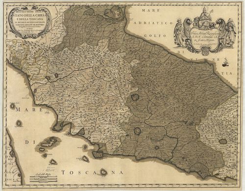
| Title | Descrittione delle Stato della Chiesa e della Toscana… |
| Main title | Az Egyházi Állam és a Toscana-i Nagyhercegség térképe 1763 körül. |
133. Statvs Ecclesiastici nec non Magni Dvcatvs Toscanae nova Tab... [B VII a 373]
Institute and Museum of Military History •
B VII a
•
B VII Olaszország
•
B I–XV. Európa
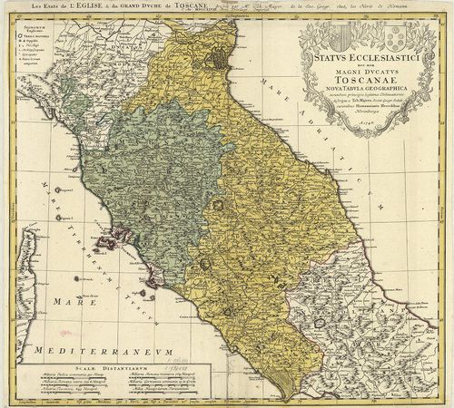
| Title | Statvs Ecclesiastici nec non Magni Dvcatvs Toscanae nova Tabvla Geographica. – Les Etats de l’Eglise et du Grand Dvche de Toscane… |
| Main title | Az Egyházi Állam és Toscana-i Nagyhercegség térképe 1748-ban. |
134. Lo Stato Ecclesiastico diviso nelle sue Provincie con le Reg... [B VII a 378]
Institute and Museum of Military History •
B VII a
•
B VII Olaszország
•
B I–XV. Európa
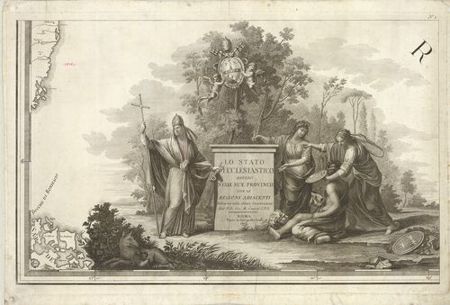
| Title | Lo Stato Ecclesiastico diviso nelle sue Provincie con le Regioni adiacenti… |
| Main title | Az Egyházi Állam térképe 1805-ben. |
135. Nuova Carta degli Stati Pontifici Meridionali. [B VII a 382]
Institute and Museum of Military History •
B VII a
•
B VII Olaszország
•
B I–XV. Európa
| Title | Nuova Carta degli Stati Pontifici Meridionali. |
| Main title | 2 mt.: 1. [Róma és környéke hegyrajza.] 2. Tavola Peutingeriana.] |
| Subject | A Pápai Állam térképe 1820-ban. |
136. Carta topografica dello Stato Pontificio e del Gran-Ducato d... [B VII a 385]
Institute and Museum of Military History •
B VII a
•
B VII Olaszország
•
B I–XV. Európa
| Title | Carta topografica dello Stato Pontificio e del Gran-Ducato di Toscana construtta sopra misure astronomico trigonometriche ed incisa sopra pietra… Topographische Karte des Kirchenstaates und des Grossherzogthunes Toscana… |
| Main title | Az Egyházi Állam és a Toscana-i Nagyhercegség topográfiai térképe 1851-ben. |
137. Legatione del Dvcato d’Vrbino con la Diocesi, e Governo di C... [B VII a 386]
Institute and Museum of Military History •
B VII a
•
B VII Olaszország
•
B I–XV. Európa
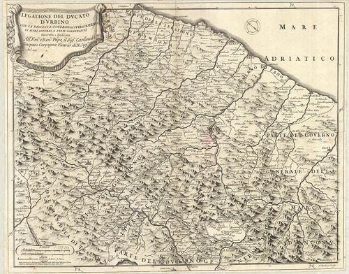
| Title | Legatione del Dvcato d’Vrbino con la Diocesi, e Governo di Citta di Castello et Attri Governi e Stati Confinanti. |
| Main title | Urbino hercegség és a környező egyházmegyék térképe 1697-ben. |
138. La Marca Anconitana, e Fermana… [B VII a 388]
Institute and Museum of Military History •
B VII a
•
B VII Olaszország
•
B I–XV. Európa
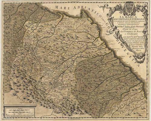
| Title | La Marca Anconitana, e Fermana… |
| Main title | Le Marche tartomány: Ancona és Fermo megyék térképe a határos részekkel 1711-ben. |
139. Il Lazio con le sue piu Cospicue Strade Antiche e Moderne e ... [B VII a 391]
Institute and Museum of Military History •
B VII a
•
B VII Olaszország
•
B I–XV. Európa
| Title | Il Lazio con le sue piu Cospicue Strade Antiche e Moderne e principali Casali, e Tenute di esso… |
| Main title | Lazio tartomány térképe 1693-ban hálózattal. |
140. Carta del Patrimonio de S.[an] Pietro. [B VII a 394/2]
Institute and Museum of Military History •
B VII a
•
B VII Olaszország
•
B I–XV. Európa
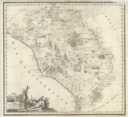
| Title | Carta del Patrimonio de S.[an] Pietro. |
| Main title | Az Egyházi Állam térképe 1802-ben. |
141. Tavola generale della Provincia dell’ Umbria… [B VII a 397]
Institute and Museum of Military History •
B VII a
•
B VII Olaszország
•
B I–XV. Európa
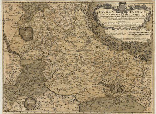
| Title | Tavola generale della Provincia dell’ Umbria… |
| Main title | Umbria tartomány általános térképe 1712-ben. |
142. Carta del Territorio d’Orvieto e Territorio di Pervgia [B VII a 397/2]
Institute and Museum of Military History •
B VII a
•
B VII Olaszország
•
B I–XV. Európa
| Title | Carta del Territorio d’Orvieto e Territorio di Pervgia |
| Main title | Orvieto járás és Perugia tartomány környékének térképe 1803-ban. |
143. Carta della provincia della Lunigiana. B. A. W. H. XLV. Th. ... [B VII a 398]
Institute and Museum of Military History •
B VII a
•
B VII Olaszország
•
B I–XV. Európa
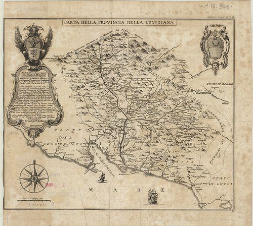
| Title | Carta della provincia della Lunigiana. B. A. W. H. XLV. Th. N. Z. XXVII. Th. |
| Main title | Lunigiana tartomány térképe 1759-ben. |
144. Carta topografica del Monte Vesuvio. [B VII a 404/5]
Institute and Museum of Military History •
B VII a
•
B VII Olaszország
•
B I–XV. Európa
| Title | Carta topografica del Monte Vesuvio. |
| Main title | Vezúv és környékének topográfiai térképe 1875–76-ban. |
145. Isola d’Ischia, Procida, Vivara. Nr. 4. [B VII a 409]
Institute and Museum of Military History •
B VII a
•
B VII Olaszország
•
B I–XV. Európa
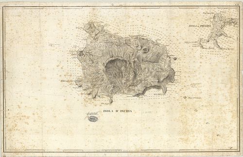
| Title | Isola d’Ischia, Procida, Vivara. Nr. 4. |
| Main title | Ischia, Procida és Vivara szigetek térképe 1820 körül. |
146. Isola d’Ischia. [B VII a 410]
Institute and Museum of Military History •
B VII a
•
B VII Olaszország
•
B I–XV. Európa
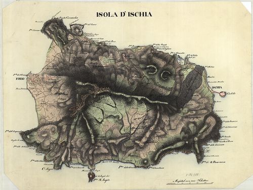
| Title | Isola d’Ischia. |
| Main title | Ischia sziget térképe 1822 körül. |
147. Sargedna ed Isola aggiacenti secondo lo Stato presente. A. A... [B VII a 412]
Institute and Museum of Military History •
B VII a
•
B VII Olaszország
•
B I–XV. Európa
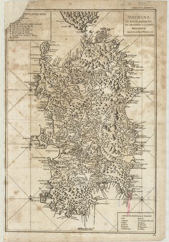
| Title | Sargedna ed Isola aggiacenti secondo lo Stato presente. A. A. W. H. XLV. Th. N. Z. XXVII. Th. |
| Main title | Szardinia sziget és a környező szigetek általános térképe 1773-ban. |
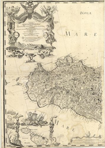
148. Insvlae sive Regni Siciliae ante omnes Mediterranei maris In... [B VII a 460]
Institute and Museum of Military History •
B VII a
•
B VII Olaszország
•
B I–XV. Európa
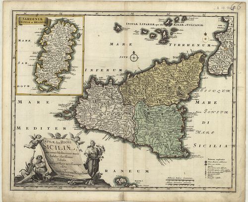
| Title | Insvlae sive Regni Siciliae ante omnes Mediterranei maris Insulas clarissimae Tabula… |
| Main title | 1 mt.: Sardiniae Insvia Regnum. (Szardiniai Királyság.) |
| Subject | A Szicíliai Királyság és a környező szigetek térképe 1720 körül. |
149. Nova et accurata Siciliae Regionum, Urbium Castellorum, Pago... [B VII a 462]
Institute and Museum of Military History •
B VII a
•
B VII Olaszország
•
B I–XV. Európa
| Title | Nova et accurata Siciliae Regionum, Urbium Castellorum, Pagorum, Montium, Sylvarum, Planitierum, Viarum, Sitiuum… |
| Main title | A Szicíliai Királyság térképe 1719–1721-ben. |
150. Norditalien. [B VII a 468]
Institute and Museum of Military History •
B VII a
•
B VII Olaszország
•
B I–XV. Európa
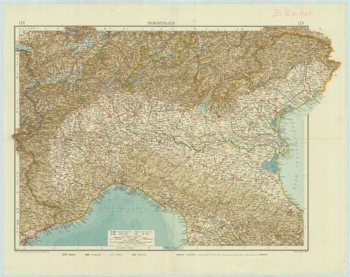
| Title | Norditalien. |
| Main title | Észak-Olaszország térképe 1905-ben. |
151. Sicilia. [B VII a 469]
Institute and Museum of Military History •
B VII a
•
B VII Olaszország
•
B I–XV. Európa
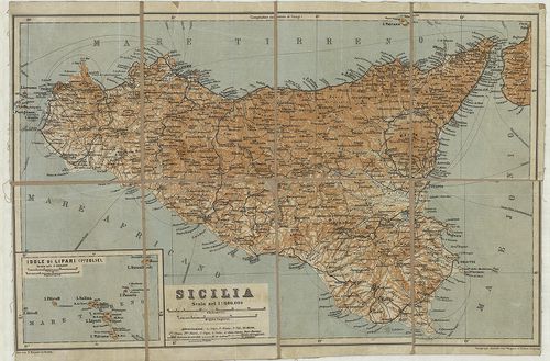
| Title | Sicilia. |
| Main title | Mt.: Isole di Lipari. (I.-le Eolie.) (Lipari-szk.) |
| Subject | Szicília térképe 1840-es években. |
152. Az Olasz háború térképe. [B VII a 474]
Institute and Museum of Military History •
B VII a
•
B VII Olaszország
•
B I–XV. Európa
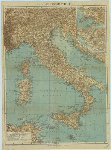
| Title | Az Olasz háború térképe. |
| Main title | 2 mt.: 1. Napoli környéke. |
| Subject | 2. Róma környéke. |
153. Olaszország. [B VII a 476]
Institute and Museum of Military History •
B VII a
•
B VII Olaszország
•
B I–XV. Európa
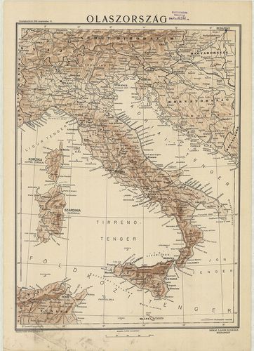
| Title | Olaszország. |
154. Italia. [B VII a 479]
Institute and Museum of Military History •
B VII a
•
B VII Olaszország
•
B I–XV. Európa

| Title | Italia. |
| Main title | Olaszország térképe 1947 körül. |
155. Gea-Verkehrskarte-Italien. Übersichtskarte. [B VII a 480]
Institute and Museum of Military History •
B VII a
•
B VII Olaszország
•
B I–XV. Európa
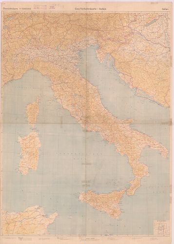
| Title | Gea-Verkehrskarte-Italien. Übersichtskarte. |
| Main title | Olaszország áttekintő térképe úthálózattal 1944-ben. |
156. Italien. Flemmings Generalkarten. Nr. 18. [B VII a 481]
Institute and Museum of Military History •
B VII a
•
B VII Olaszország
•
B I–XV. Európa
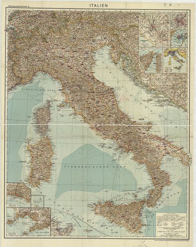
| Title | Italien. Flemmings Generalkarten. Nr. 18. |
| Main title | 8 mt.: 1. [Róma és környéke.] |
| Subject | 2. [Róma.] |
157. Italija. Ucsebnaja Karta. [B VII a 482/1]
Institute and Museum of Military History •
B VII a
•
B VII Olaszország
•
B I–XV. Európa
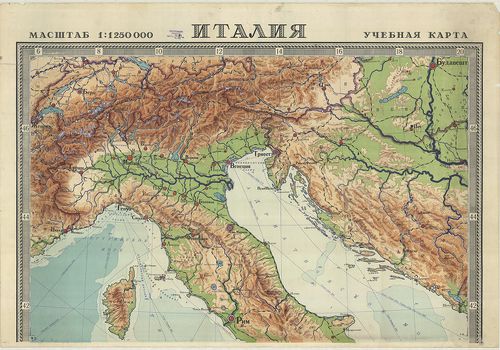
| Title | Italija. Ucsebnaja Karta. |
| Main title | Olaszország iskolai falitérképe 1949-ben. |
158. Charte von Italien. [B VII a 485]
Institute and Museum of Military History •
B VII a
•
B VII Olaszország
•
B I–XV. Európa
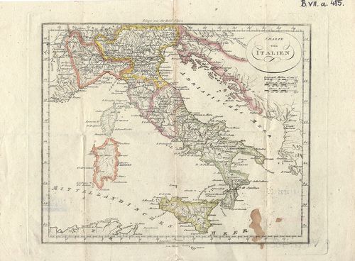
| Title | Charte von Italien. |
| Main title | Olaszország térképe a 18. században. |
159. [Az Olasz Alpok térképe.] [B VII a 486]
Institute and Museum of Military History •
B VII a
•
B VII Olaszország
•
B I–XV. Európa
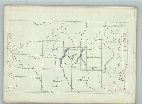
| Title | [Az Olasz Alpok térképe.] |
| Main title | 8 tl.: Valle d’Aosta, Valle d’Ossola, Tre Laghi, Valtellina bassa, Valtellina alta, Novara, Milano, Brescia. |
160. Közép és Felső Olasz Ország vagy is Egyházi Fejedelemség, To... [B VII a 487]
Institute and Museum of Military History •
B VII a
•
B VII Olaszország
•
B I–XV. Európa
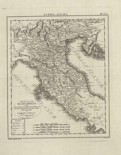
| Title | Közép és Felső Olasz Ország vagy is Egyházi Fejedelemség, Toskana, Modena, Parma, Piecsenza, Lukka Herczegségek és Lombard Velenczei Királyságok. |
| Main title | M.: régi római mérföldek. |
161. Olasz Ország, Dalmátzia Közönséges Földképe. [B VII a 488]
Institute and Museum of Military History •
B VII a
•
B VII Olaszország
•
B I–XV. Európa
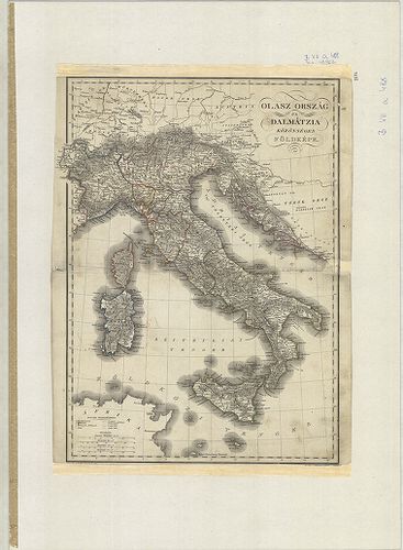
| Title | Olasz Ország, Dalmátzia Közönséges Földképe. |
| Main title | M.: kül. mérföld. |
162. Carta del Grande Altopiano della Carsia Giulia. [B VII a 489]
Institute and Museum of Military History •
B VII a
•
B VII Olaszország
•
B I–XV. Európa
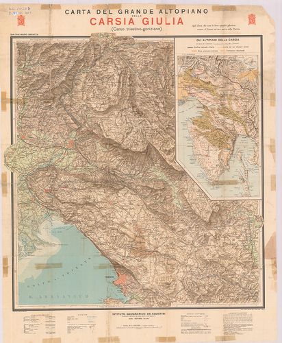
| Title | Carta del Grande Altopiano della Carsia Giulia. |
| Main title | 1 mell. térk.: Gli altipiani della carsia (karsztos magasfennsíkok).. |
| Subject | A Júliai-karsztok nagy fennsíkjának térképe. |
163. Istria. [B VII a 490]
Institute and Museum of Military History •
B VII a
•
B VII Olaszország
•
B I–XV. Európa
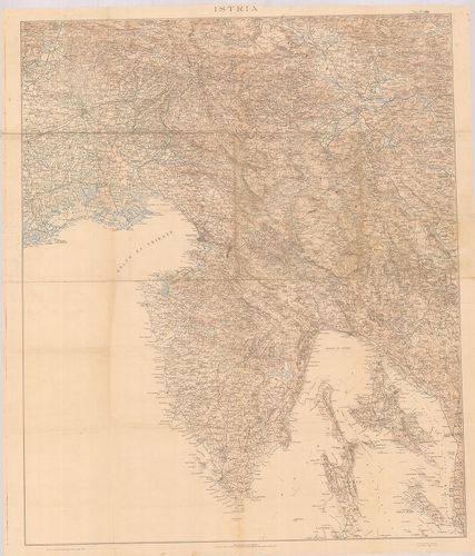
| Title | Istria. |
| Main title | Az Isztriai-fsz. térképe. |
164. [Észak-Olaszország térképe.] [B VII a 491]
Institute and Museum of Military History •
B VII a
•
B VII Olaszország
•
B I–XV. Európa
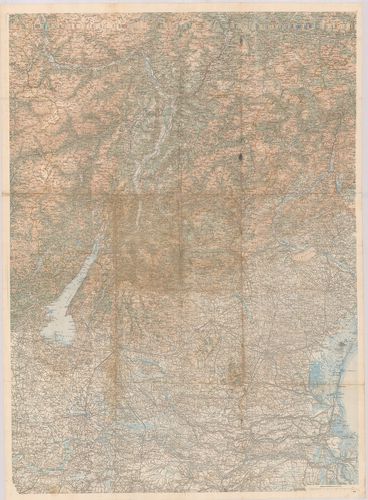
| Title | [Észak-Olaszország térképe.] |
| Main title | Kétszázezres sorozattérkép össznyomata az I. Világháború idejéből. |
165. Scacchiere Basso Isonzo. [B VII a 493]
Institute and Museum of Military History •
B VII a
•
B VII Olaszország
•
B I–XV. Európa
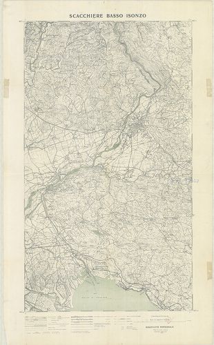
| Title | Scacchiere Basso Isonzo. |
| Main title | A Isonzo harcmező környéke. |
166. Topografia della provincia di Venezia. [B VII a 494]
Institute and Museum of Military History •
B VII a
•
B VII Olaszország
•
B I–XV. Európa
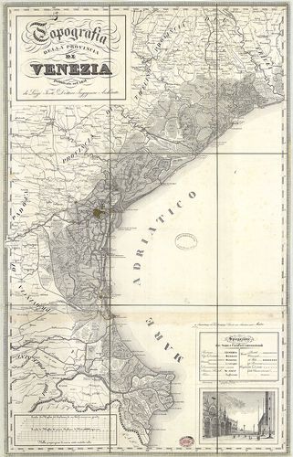
| Title | Topografia della provincia di Venezia. |
| Main title | A Velence-i tartomány térképe + katonai leírása. |
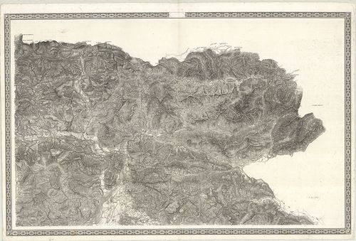
167. Hypsometrische Karte von Mittel-Italien. [B VII b 4]
Institute and Museum of Military History •
B VII b
•
B VII Olaszország
•
B I–XV. Európa
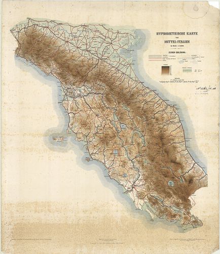
| Title | Hypsometrische Karte von Mittel-Italien. |
| Main title | Közép-Olaszország hipszometrikus térképe 1882 körül. |
168. Carte des Alpes relative á la guerre de 1792. [B VII b 6/1]
Institute and Museum of Military History •
B VII b
•
B VII Olaszország
•
B I–XV. Európa
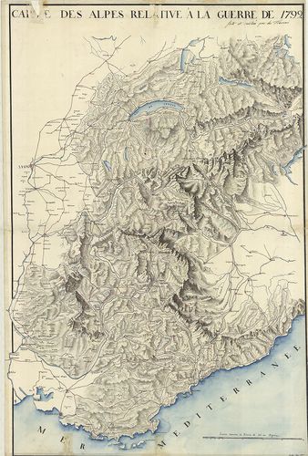
| Title | Carte des Alpes relative á la guerre de 1792. |
| Main title | Az Alpok térképe 1792-ben. |
169. Rundschau von Luschari-Berge. I.–II. Blatt. [B VII b 14]
Institute and Museum of Military History •
B VII b
•
B VII Olaszország
•
B I–XV. Európa

| Title | Rundschau von Luschari-Berge. I.–II. Blatt. |
| Main title | A Luschari-hegy madártávlatos képe 1889-ben. |
170. Karte der Marmolatagruppe. [B VII b 16]
Institute and Museum of Military History •
B VII b
•
B VII Olaszország
•
B I–XV. Európa
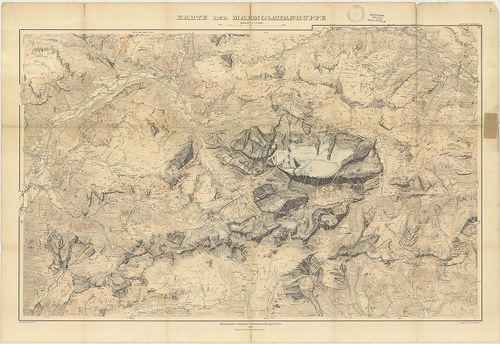
| Title | Karte der Marmolatagruppe. |
| Main title | A Marmolada-hegycsoport térképe 1905-ben. |
171. Riviera da Nervi a Voltri. [B VII b 19]
Institute and Museum of Military History •
B VII b
•
B VII Olaszország
•
B I–XV. Európa
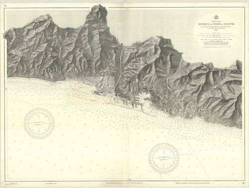
| Title | Riviera da Nervi a Voltri. |
| Main title | Nervi és Voltri közötti partszakasz hajózási térképe. |
172. Gruppo di Brenta. Carte delle zone Turistiche d’Italia. [B VII b 20]
Institute and Museum of Military History •
B VII b
•
B VII Olaszország
•
B I–XV. Európa
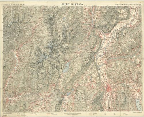
| Title | Gruppo di Brenta. Carte delle zone Turistiche d’Italia. |
| Main title | A Brenta hegycsoport és tágabb környékének térképe az 1920-as években. |
173. Il Vesuvio. [B VII b 27]
Institute and Museum of Military History •
B VII b
•
B VII Olaszország
•
B I–XV. Európa
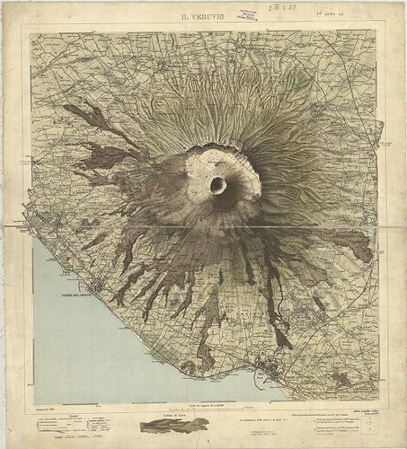
| Title | Il Vesuvio. |
| Main title | A Vezúv és környékének térképe 1908-ban. |
174. Carta Idrografica Stradale Amministrativa Consorziale della ... [B VII b 29]
Institute and Museum of Military History •
B VII b
•
B VII Olaszország
•
B I–XV. Európa
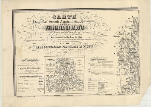
| Title | Carta Idrografica Stradale Amministrativa Consorziale della Provincia di Padova… |
| Main title | 8 mt.: 1. Cittadella. 2. Camposampiero. 3. Monselice. 4. Montagnana. 5. Este. 6. Padova. 7. Conselve. 8. Piove. |
| Subject | Padova tartományvízrajzi, út- és közigazgatási térképe 1882-ben. |
175. Icon sinus Baiarum uti nunc videtur… [B VII b 35/10]
Institute and Museum of Military History •
B VII b
•
B VII Olaszország
•
B I–XV. Európa
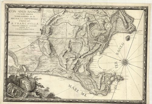
| Title | Icon sinus Baiarum uti nunc videtur… |
| Main title | A Pozzuoli-öböl (Nápolytól Ny-ra) térképe az 1720-as évek körül. |
176. Plan du Golfe de la Spezia Côtes d’ Italia. (Duché de Génes)... [B VII b 35/13]
Institute and Museum of Military History •
B VII b
•
B VII Olaszország
•
B I–XV. Európa
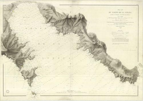
| Title | Plan du Golfe de la Spezia Côtes d’ Italia. (Duché de Génes). |
| Main title | A Speziai-öböl térképe 1846–67-ben. |
177. Laguna Veneta. Mappa topografica. [B VII b 36/2]
Institute and Museum of Military History •
B VII b
•
B VII Olaszország
•
B I–XV. Európa
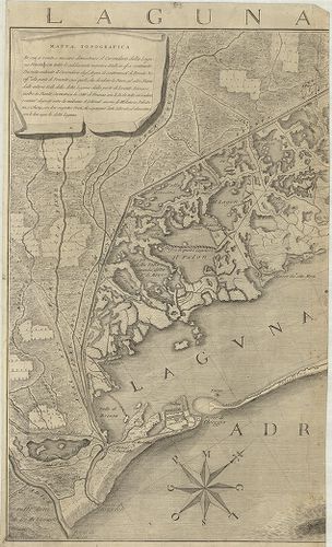
| Title | Laguna Veneta. Mappa topografica. |
| Main title | Mt.: [Venezia.] |
| Subject | A Velence-i laguna topográfiai térképe 1780-ban. |
178. Plan des Adda-Flus[s], von Trezzo bis zu dem Einflus[s] in P... [B VII b 37]
Institute and Museum of Military History •
B VII b
•
B VII Olaszország
•
B I–XV. Európa
| Title | Plan des Adda-Flus[s], von Trezzo bis zu dem Einflus[s] in Poo dessen Lauff sich durch das Mailendische und Lodisanische erstrecket. |
| Main title | Az Adda folyó és közvetlen környéke (Trezzo-tól a Pó-ig.) 1750 körül. |
179. Mittelmeer Westküste von Italien Capo Circeo bis Capo Palinu... [B VII b 38]
Institute and Museum of Military History •
B VII b
•
B VII Olaszország
•
B I–XV. Európa
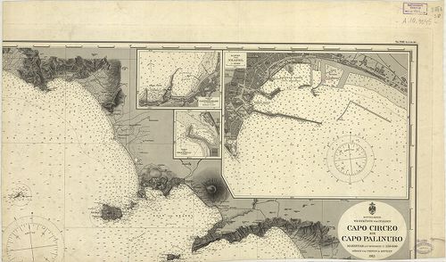
| Title | Mittelmeer Westküste von Italien Capo Circeo bis Capo Palinuro. Nr. 506. (Tit. V. Nr. 94.) |
| Main title | 3 mt.: 1. Hafen von Neapel (a Nápoly-i kikötő). |
| Subject | 2. Hafen von Castellamare di Stabia. |
180. Dissegno fatto per le Regolation della Piaue et altri Fiumi ... [B VII b 68]
Institute and Museum of Military History •
B VII b
•
B VII Olaszország
•
B I–XV. Európa
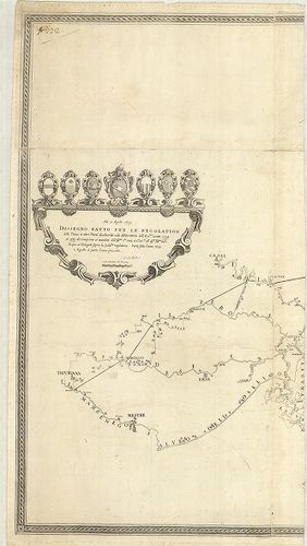
| Title | Dissegno fatto per le Regolation della Piaue et altri Fiumi … |
| Main title | A Piave és a betorkolló folyók szabályozásának térképe 1633–39-ben. |
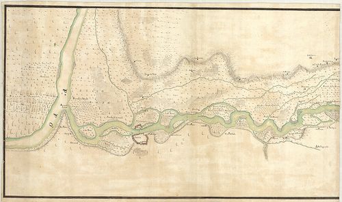
181. Corso del Po per la Lombardia dalle sve fonti sino al Mare… [B VII b 72]
Institute and Museum of Military History •
B VII b
•
B VII Olaszország
•
B I–XV. Európa
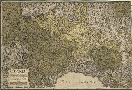
| Title | Corso del Po per la Lombardia dalle sve fonti sino al Mare… |
| Main title | A Pó-síkság és a környező részek térképe 1733-ban. |
182. Mappa del Corso e stato presentaneo del fiume Po in Vicinanz... [B VII b 74]
Institute and Museum of Military History •
B VII b
•
B VII Olaszország
•
B I–XV. Európa
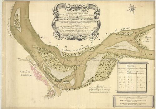
| Title | Mappa del Corso e stato presentaneo del fiume Po in Vicinanza della Citta di Cremona … Közreműködött: Bernardino Mazzoni–Adamo du Ponte … |
| Main title | A Pó és környéke Cremona közelében 1726–28-ban. |
183. Le Cours du Po. [B VII b 80]
Institute and Museum of Military History •
B VII b
•
B VII Olaszország
•
B I–XV. Európa
| Title | Le Cours du Po. |
| Main title | A Pó és környékének térképe 1703–1734-ben. |
184. Dissegno delle valli et Isole del fiume Ticino delli 15 otto... [B VII b 103]
Institute and Museum of Military History •
B VII b
•
B VII Olaszország
•
B I–XV. Európa
| Title | Dissegno delle valli et Isole del fiume Ticino delli 15 ottobre 1681. |
| Main title | A Ticino folyó térképe 1681–1714-ben. |
185. Corso del Fiume Ticino dal Porto di Parasacco sino alla sboc... [B VII b 104]
Institute and Museum of Military History •
B VII b
•
B VII Olaszország
•
B I–XV. Európa
| Title | Corso del Fiume Ticino dal Porto di Parasacco sino alla sbocatura del Gravallone in Ticino al disotto di Pauia. |
| Main title | A Ticino folyó térképe 1721 körül. |
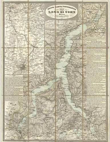
186. Nuova carta topografica del Lago di Como. [B VII b 106]
Institute and Museum of Military History •
B VII b
•
B VII Olaszország
•
B I–XV. Európa
| Title | Nuova carta topografica del Lago di Como. |
| Main title | Mt.: [Milano-Como közti terület.] |
| Subject | A Comoi-tó és környékének topográfiai térképe 1850 körül. |
187. Carta geologica d’Italia. Spezia. F° 95. Domb.: D. Zaccagna ... [B VII b 121]
Institute and Museum of Military History •
B VII b
•
B VII Olaszország
•
B I–XV. Európa
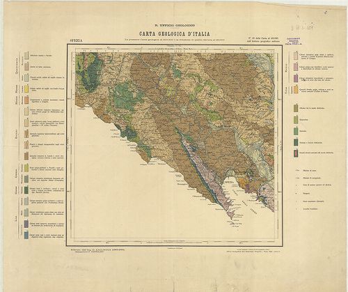
| Title | Carta geologica d’Italia. Spezia. F° 95. Domb.: D. Zaccagna (1884–1896). |
| Main title | La Spezia és tágabb környékének geológiai térképe 1928-ban. |
188. Carta Ipsometrica D’Italia. 1921. [B VII b 134]
Institute and Museum of Military History •
B VII b
•
B VII Olaszország
•
B I–XV. Európa
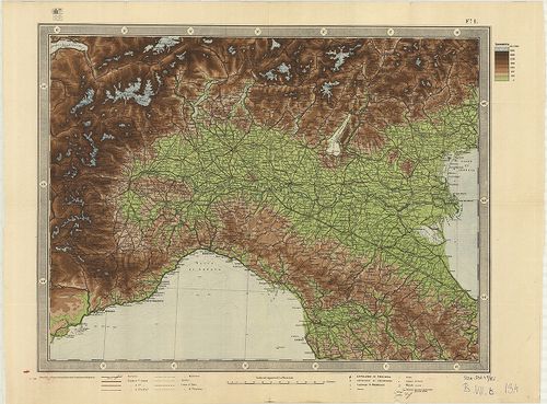
| Title | Carta Ipsometrica D’Italia. 1921. |
| Main title | Olaszország hipszometrikus térképe 1921-ben. |
189. Karten-Skizze… Mincio, Po und der Etsch. [B VII b 135]
Institute and Museum of Military History •
B VII b
•
B VII Olaszország
•
B I–XV. Európa
| Title | Karten-Skizze… Mincio, Po und der Etsch. |
| Main title | A Mincio, Pó és Ersch folyók átkelőhelyeinek térképvázlata. |
190. Principato Citra és Basilicata úti térképe. [B VII c 33]
Institute and Museum of Military History •
B VII c
•
B VII Olaszország
•
B I–XV. Európa
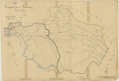
| Title | Principato Citra és Basilicata úti térképe. |
| Main title | A magyar légió működési területe 1861–62-ben Dél-Olaszországban. |
191. Strassen Karte der Alpen und des nördlichen Apennin. [B VII c 42]
Institute and Museum of Military History •
B VII c
•
B VII Olaszország
•
B I–XV. Európa
| Title | Strassen Karte der Alpen und des nördlichen Apennin. |
| Main title | Az Alpok és Appenninek északi részének úttérképe 1859-ben. |
192. Carta Itineraria del Regno Lombardo-Veneto indicante tutte l... [B VII c 46]
Institute and Museum of Military History •
B VII c
•
B VII Olaszország
•
B I–XV. Európa
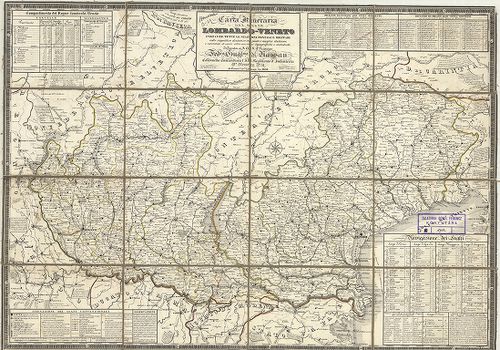
| Title | Carta Itineraria del Regno Lombardo-Veneto indicante tutte le stazioni postali e militari… |
| Main title | A Lombard-Velencei Királyság úttérképe 1832-ben a postai és katonai állomások feltüntetésével. |
193. Carta Postale e Stradale dell’ Italia. [B VII c 47]
Institute and Museum of Military History •
B VII c
•
B VII Olaszország
•
B I–XV. Európa
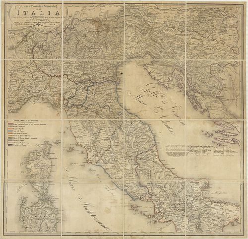
| Title | Carta Postale e Stradale dell’ Italia. |
| Main title | Olaszország északi és középső részének posta és úttérképe. |
194. Routenskelett. Beilage 1. [B VII c 52]
Institute and Museum of Military History •
B VII c
•
B VII Olaszország
•
B I–XV. Európa
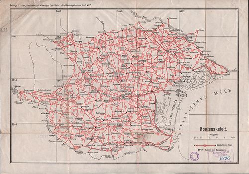
| Title | Routenskelett. Beilage 1. |
| Main title | Az osztrák–olasz határvidék úttérképének áttekintő hálózata 1910 körül. |
195. Strassen-Karte des Lombardisch-Venezianischen Koenigreiches.... [B VII c 57]
Institute and Museum of Military History •
B VII c
•
B VII Olaszország
•
B I–XV. Európa
| Title | Strassen-Karte des Lombardisch-Venezianischen Koenigreiches. – Gouvernement Lombardei. |
| Main title | A Lombard Kormányzóság úttérképe. |
196. Atlante stradale d’Italia del Touring Club Italiano. VII. [B VII c 58]
Institute and Museum of Military History •
B VII c
•
B VII Olaszország
•
B I–XV. Európa

| Title | Atlante stradale d’Italia del Touring Club Italiano. VII. |
| Main title | Korzika és Szárdinia úttérképe. |
197. Schematische Telegraphen- und Telephonkarte Norditaliens… [B VII c 61/2]
Institute and Museum of Military History •
B VII c
•
B VII Olaszország
•
B I–XV. Európa
| Title | Schematische Telegraphen- und Telephonkarte Norditaliens… |
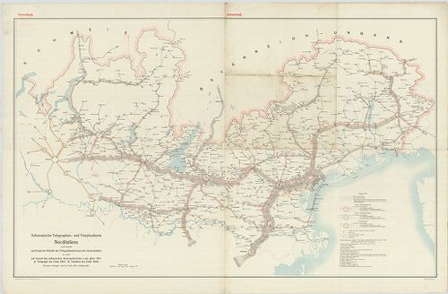
| Main title | Észak-Olaszország távíró és telefonhálózata 1911 körül. |
198. Etat de la maison d’Autriche en Italie D’aprés le Traité de ... [B VII c 74]
Institute and Museum of Military History •
B VII c
•
B VII Olaszország
•
B I–XV. Európa
| Title | Etat de la maison d’Autriche en Italie D’aprés le Traité de Paix de Campo Formio prés d’Udine du 17. Octobre 1797. |
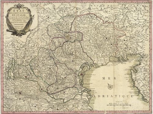
| Main title | Olaszország: Ausztria tartománya a Campoformioi békeszerződés után 1797-ben. |
199. Tipo di esecuzone del confine Milanese col Cremasco da Carav... [B VII c 81]
Institute and Museum of Military History •
B VII c
•
B VII Olaszország
•
B I–XV. Európa
| Title | Tipo di esecuzone del confine Milanese col Cremasco da Caravaggio sino a crespiatica inclusi voluto dal trattaro di Mantova. |
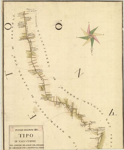
| Main title | Milanó és Crema tartomány határtérképe az 1756-ban Mantovában kötött szerződés alapján. |
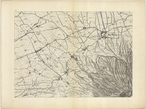
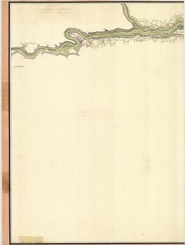
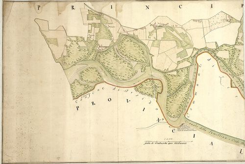
200. [A Mincio folyó Valeggio és Monzambano közötti szakaszának t... [B VII c 126/1]
Institute and Museum of Military History •
B VII c
•
B VII Olaszország
•
B I–XV. Európa
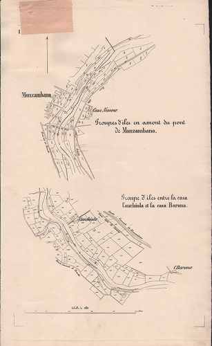
| Title | [A Mincio folyó Valeggio és Monzambano közötti szakaszának térképe.] |