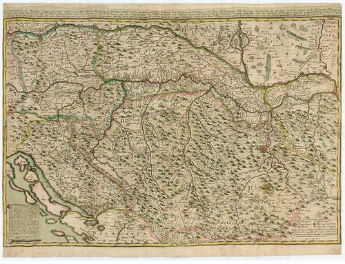
41. Geometrische Carte von Türkisch Croatien der Herzegovina und... [B IX a 936]
Institute and Museum of Military History •
B IX a
•
B IX Ausztria–Magyarország
•
B I–XV. Európa
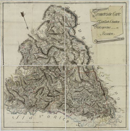
| Title | Geometrische Carte von Türkisch Croatien der Herzegovina und einem Theil von Bosnien. |
| Main title | Bosznia–Hercegovina török fennhatóság alatti területének általános térképe a 18. század közepén. (Gradiška–Brod–Mostar között.) |
42. Karte von Bosnien, der Hercegovina und des Paschaliks von No... [B IX a 939]
Institute and Museum of Military History •
B IX a
•
B IX Ausztria–Magyarország
•
B I–XV. Európa
| Title | Karte von Bosnien, der Hercegovina und des Paschaliks von Novibazar. |
| Main title | Bosznia, Hercegovina és Novi Bazar (Novi Pazar) térképe 1865-ben. |
43. Karte von Bosnien, der Hercegovina und des Paschaliks von No... [B IX a 940]
Institute and Museum of Military History •
B IX a
•
B IX Ausztria–Magyarország
•
B I–XV. Európa
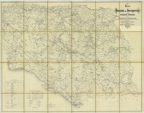
| Title | Karte von Bosnien, der Hercegovina und des Paschaliks von Novibazar. |
| Main title | Bosznia, Hercegovina és Novibazar (Novi Pazar) térképe 1865-ben. |
44. General Karte von Bosnien und der Hercegovina. [B IX a 943]
Institute and Museum of Military History •
B IX a
•
B IX Ausztria–Magyarország
•
B I–XV. Európa
| Title | General Karte von Bosnien und der Hercegovina. |
| Main title | Bosznia és Hercegovina általános térképe 1885-ben. |
45. Neueste Karte der Koenigreiche Bosnien Servien Croatien und ... [B IX a 944]
Institute and Museum of Military History •
B IX a
•
B IX Ausztria–Magyarország
•
B I–XV. Európa
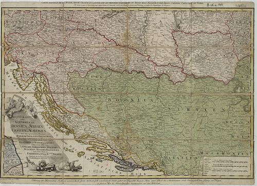
| Title | Neueste Karte der Koenigreiche Bosnien Servien Croatien und Slavonien… |
| Main title | Bosznia, Szerbia, Horvát-Szlavónia és a szomszédos államok térképe 1788-ban. |
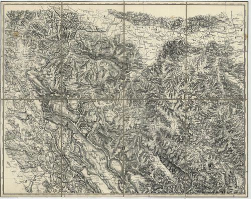
46. Karte des südöstlichen Theiles des occupations Gebietes. [B IX a 966]
Institute and Museum of Military History •
B IX a
•
B IX Ausztria–Magyarország
•
B I–XV. Európa
| Title | Karte des südöstlichen Theiles des occupations Gebietes. |
| Main title | DK-Bosznia megszállt területének térképe 1881-ben. |
47. Nova et accurata Tabula sedis belli in Regno Hungariae. Acce... [B IX a 1039]
Institute and Museum of Military History •
B IX a
•
B IX Ausztria–Magyarország
•
B I–XV. Európa
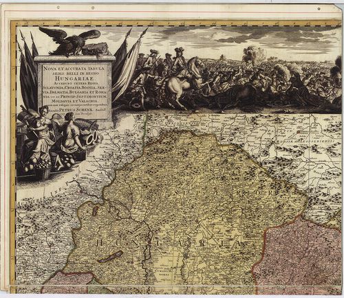
| Title | Nova et accurata Tabula sedis belli in Regno Hungariae. Accendunt cetera Regna Sclavonia, Croatia, Bosnia, Servia, Dalmatia, Bulgaria et Romania… |
| Main title | A Magyar Királyság , Horvát-Szlavónia, Bosznia, Szerbia, Dalmácia, Bulgária, Moldva, Erdély, Havasalföld térképe 1717-ben. |
48. Royaume de Hongrie, Principaute de Transilvanie, Sclavonie, ... [B IX a 1088]
Institute and Museum of Military History •
B IX a
•
B IX Ausztria–Magyarország
•
B I–XV. Európa
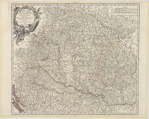
| Title | Royaume de Hongrie, Principaute de Transilvanie, Sclavonie, Croatie et partie de la Principauté de Valaqie, de la Bosnie, de la Servie et de la Bulgarie. |
| Main title | A Magyar Királyság, Erdély, Horvát-Szlavónia, Havasalföld, Bosznia, Szerbia, Bulgária térképe. |
49. Carte von dem Temesvarer Banat und dem König. Servien, nebst... [B IX a 1210]
Institute and Museum of Military History •
B IX a
•
B IX Ausztria–Magyarország
•
B I–XV. Európa
| Title | Carte von dem Temesvarer Banat und dem König. Servien, nebst einen Theil von Ungarn, Slavonien und Bosnien. |
| Main title | A Temesi Bánság és a Szerb Királyság, valamint a Magyar Királyság, Szlavónia és Bosznia egy részének totográfiai térképe. |
50. Carte Originale et particuliere de la Bosnie... [B IX a 1237]
Institute and Museum of Military History •
B IX a
•
B IX Ausztria–Magyarország
•
B I–XV. Európa
| Title | Carte Originale et particuliere de la Bosnie... |
| Main title | Bosznia, Szlavónia, Horvátország és a határőrvidékek térképe, a Magyar Királyság és Szerbia egy részével. |
51. Karte Boszne i Hercegovine. [B IX b 80/1]
Institute and Museum of Military History •
B IX b
•
B IX Ausztria–Magyarország
•
B I–XV. Európa
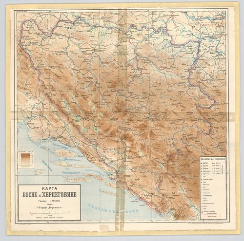
| Title | Karte Boszne i Hercegovine. |
| Main title | Bosznia és Hercegovina hegyvízrajzi térképe 1909-ben. |
52. Österreich–Ungarn und Bosnien-Hercegovina. [B IX c 21/5]
Institute and Museum of Military History •
B IX c
•
B IX Ausztria–Magyarország
•
B I–XV. Európa
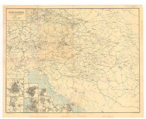
| Title | Österreich–Ungarn und Bosnien-Hercegovina. |
| Main title | 12 mt. 1. Wien. (Bécs.) 2. Budapest. 3. Prag. (Prága.) 4. Triest. (Trieste.) 5. Innsbruck. 6. Graz. 7. Salzburg. 8. Teplitz. (Teplice.) 9. Aussig. (Usti n. Laben.) 10. Karlsbad. (Karlovy Vary.) 11. Bodenbach-Teschen. (Podmokly-Těšin.) 12. Krakau. (Krakow.) |
| Subject | Az Osztrák–Magyar Monarchia és Bosznia-Hercegovina vasúttérképe 1917-ben. |
53. Magyarország és Ausztria, valamint Bosznia és Hercegovina, v... [B IX c 54]
Institute and Museum of Military History •
B IX c
•
B IX Ausztria–Magyarország
•
B I–XV. Európa
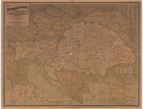
| Title | Magyarország és Ausztria, valamint Bosznia és Hercegovina, vasúti és Gőzhajózási térképe. |
| Main title | 6 mt. 1. A Balkán-félsziget vasúti térképe. 2. Pozsony vasúti hálózatának helyzetrajza. 3. Prag (Prága) vasúti hálózatának helyzetrajza. 4. A Fiumei pályaudvar és kikötő helyzetrajza. 5. Wien (Bécs) vasúti hálózatának helyzetrajza. 6. Budapest vasúti hálózatának helyzetrajza. |
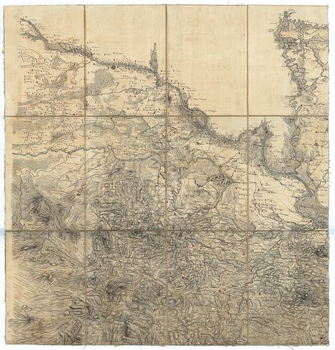
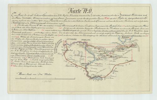
54. Karte der Séparationa und neinen Cordons Linie, wieselbe nac... [B IX c 906]
Institute and Museum of Military History •
B IX c
•
B IX Ausztria–Magyarország
•
B I–XV. Európa
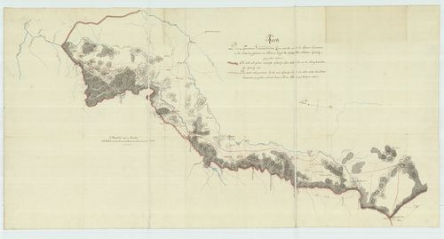
| Title | Karte der Séparationa und neinen Cordons Linie, wieselbe nach der Sistover Conventions in der tirkischen Gebieth von Bosnien längst der Carlstaedter Militair Graenitz. |
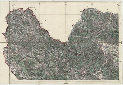
| Main title | Bosznia és a Károlyvárosi Határőrvidék határos területeinek térképe 1791-ben. |
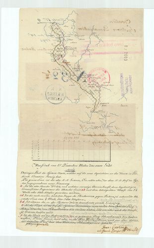
55. Karte Litt: G. Uber die von Medvedia glavicza des Berges Deb... [B IX c 907]
Institute and Museum of Military History •
B IX c
•
B IX Ausztria–Magyarország
•
B I–XV. Európa
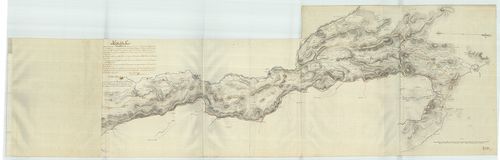
| Title | Karte Litt: G. Uber die von Medvedia glavicza des Berges Debelloberdo Laengs denen vier Karlstaedter Regimenten der Liccaner – Ottoschaner – Oguliner und Szluiner sich hinziehenden der maligen Graenzen,… |
| Main title | Bosznia és a Károlyvárosi Határőrvidék határos területeinek térképe 1791-ben. |
56. Carte Litt: G. Aus welecher der ganze Zusamenhang der Graenz... [B IX c 909]
Institute and Museum of Military History •
B IX c
•
B IX Ausztria–Magyarország
•
B I–XV. Európa
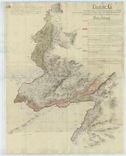
| Title | Carte Litt: G. Aus welecher der ganze Zusamenhang der Graenze von Berbir aufwerts ander Sau und dem Lauf der Unna, so dann über Medwidia glawicza bis zum Morlackischen Cannal Laengs der Zermania zu ersehen ist. |
| Main title | Bosznia és a Károlyvárosi Határőrvidék határos területeinek térképe 1791-ben. |
57. Des jenigen Theil der S˙stover Karte, welcher auf die neue A... [B IX c 916]
Institute and Museum of Military History •
B IX c
•
B IX Ausztria–Magyarország
•
B I–XV. Európa
| Title | Des jenigen Theil der S˙stover Karte, welcher auf die neue Aquisition an der Unna in Türkisch Croatien Bezug hat. Karte Nro. 9. zum Tage Buch den 14. September 1792. |
| Main title | Bosznia és a Károlyvárosi Határőrvidék határos területeinek térképe az 1791-es szisztovi béke szerint. |
58. Karte Nr. 11. Eines Theils der Kraft Sistover Convention dem... [B IX c 918]
Institute and Museum of Military History •
B IX c
•
B IX Ausztria–Magyarország
•
B I–XV. Európa
| Title | Karte Nr. 11. Eines Theils der Kraft Sistover Convention dem k. k. Hof in Kroatzien zukomenden Districten, besonders aber des Drexniker (Dreznik) Teritorium und des Feldes Zavalie, … |
| Main title | Bosznia és a Károlyvárosi Határőrvidék határos területeinek térképe az 1791-es szvistovi béke szerint. |
59. Carte litt: K Der nach wahren Verhaltnissen in das Grössere ... [B IX c 919]
Institute and Museum of Military History •
B IX c
•
B IX Ausztria–Magyarország
•
B I–XV. Európa
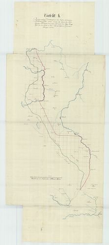
| Title | Carte litt: K Der nach wahren Verhaltnissen in das Grössere übertragenen Szistovaer Carte, … |
| Main title | Bosznia és a Károlyvárosi Határőrvidék határos területeinek térképe 1791-ben. |
60. Über die dem k. k. Hof von der Glina bis zum Wirklichen Trip... [B IX c 922]
Institute and Museum of Military History •
B IX c
•
B IX Ausztria–Magyarország
•
B I–XV. Európa
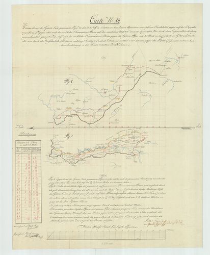
| Title | Über die dem k. k. Hof von der Glina bis zum Wirklichen Triplex Consinium nach der S˙stover Figur in der Natur zukommenden Aquisition Carte. Nro. 14. Két térk. egy lapon. |
| Main title | Bosznia és a Károlyvárosi Határőrvidék határos területének térképe 1793 körül. |