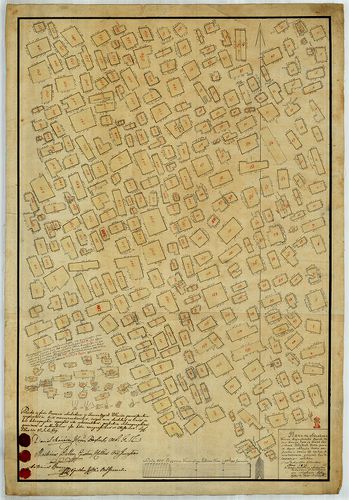
221. Gemeinde Márton Szt. Kemenes, Dorf Márton Szent Kemenes in U... [S 78 - 260. téka - Kemenesszentmárton - 1-6.]
National Archives of Hungary •
S 78 Térképek (1786-1948)
•
S Kataszteri-gyűjtemény (1786-1948)
•
S – Térképtár

| Main title | Gemeinde Márton Szt. Kemenes, Dorf Márton Szent Kemenes in Ungarn, Oedenburger Distrikt, Eisenburger Comitat, Marton Szent Kemenes falu Magyarországban, Vas megye, adóhivatal Kis Czel |
| Subject | 260. téka - Kemenesszentmárton - 1-6. Kemenesszentmárton (Vas m.) |
Content: [...] tér házak beltelkek templom Szt Martin Szent Márton egy épület fogadó [...] Content: [...] tér házak beltelkek templom Szt Martin Szent Márton egy épület fogadó [...]
222. Planum exhibens terras a diversis vicinis possessionibus Sze... [S 11 - No. 1686:1.]
National Archives of Hungary •
S 11 Kamarai térképek (1747-1882)
•
S Kormányhatósági fondokból kiemelt térképek (17. sz.-20. sz.)
•
S – Térképtár

| Main title | Planum exhibens terras a diversis vicinis possessionibus Szerfalvensibus, Kalinfalvensibus et Gyulafalvensibus pro necessitate Regii Salis Manipulationis Sugataghensis per Fiscum Regium partim iam acquisitas ... |
| Subject | No. 1686:1. Aknasugatag és környéke (Máramaros m.) birtokrendezési térképe |
Contributor: Balas Martinus Rec Sal et Mont Practicant [...]
223. Dorf Ácsteszér in Ungarn, Oedenburger Distrikt, Veszprimer C... [S 78 - 278. téka - Ácsteszér - 1-15.]
National Archives of Hungary •
S 78 Térképek (1786-1948)
•
S Kataszteri-gyűjtemény (1786-1948)
•
S – Térképtár

| Main title | Dorf Ácsteszér in Ungarn, Oedenburger Distrikt, Veszprimer Comitat |
| Subject | 278. téka - Ácsteszér - 1-15. Ácsteszér (Veszprém m., ma Komárom-Esztergom m.) |
Content: [...] lakott hely épületekkel templom Sct Martin pincék épületek utak dűlőút kutak [...] Content: [...] lakott hely épületekkel templom Sct Martin pincék épületek utak dűlőút kutak [...]
224. No. 9. Császár (Komárom m.) és Dobospuszta (Fejér m.) vitás ... [S 98 - No. 9.]
National Archives of Hungary •
S 98 Eszterházy család csákvári ága (18. sz.-19. sz.)
•
S Családi fondokból kiemelt térképek (17. sz.-20. sz.)
•
S – Térképtár
| Subject | No. 9. Császár (Komárom m.) és Dobospuszta (Fejér m.) vitás határa |
Contributor: Rosty Stephanus Plenipotentiarius Mihálkó Martinus Fiscalis Miskey Joannes Dominior Tata [...]
225. Bazuch Huttker Thal der Kais. Königl. Neusohler Berg Kammer ... [S 11 - No. 677:1-8.]
National Archives of Hungary •
S 11 Kamarai térképek (1747-1882)
•
S Kormányhatósági fondokból kiemelt térképek (17. sz.-20. sz.)
•
S – Térképtár
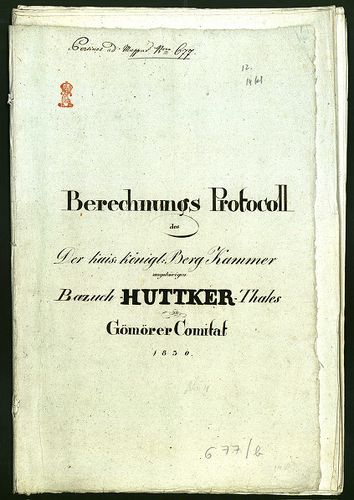
| Main title | Bazuch Huttker Thal der Kais. Königl. Neusohler Berg Kammer angehörig in Gomorer Comitat |
| Subject | No. 677:1-8. Vacok (Zólyom m., ma Bazúch, SK) egy része |
Contributor: Meiszler Martin Geometer 1 ten Classe Jokschman [...]
226. Mappa universalis terreni possessionis Bottgyán i. Comitatus... [S 12 - Div. IX. - No. 175:1-2.]
National Archives of Hungary •
S 12 Helytartótanácsi térképek (1738-1875)
•
S Kormányhatósági fondokból kiemelt térképek (17. sz.-20. sz.)
•
S – Térképtár

| Main title | Mappa universalis terreni possessionis Bottgyán i. Comitatus Pestiensis situati ... |
| Subject | Div. IX. - No. 175:1-2. Őrbottyán (Pest m.) |
Contributor: [...] Cottus Pestiensis ord judlium Egry Martinus Cottus Pestiensis jurassor
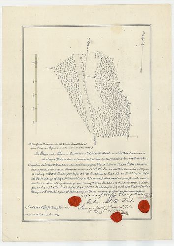
227. Geometrica delineatio terreni controversi, inter ... Episcop... [S 84 - No. 44/5.]
National Archives of Hungary •
S 84 Erdélyi főkormányszéki térképek (1754-1862)
•
S Kormányhatósági fondokból kiemelt térképek (17. sz.-20. sz.)
•
S – Térképtár
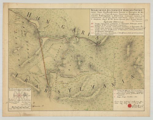
| Main title | Geometrica delineatio terreni controversi, inter ... Episcopum M. Varadiensem ac ... Familiam Banffianam in Alpibus Kalinyasza et Batrina |
| Subject | No. 44/5. Magyarország és Erdély vitás határa a Kalinyeszi völgy környékén |
Contributor: [...] Mara Sigismundus Erdélyi részről Nemai Martinus Erdély részéről
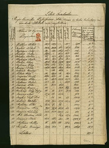
228. Planum exhibens ichnographiam vinearum allodialium in terren... [S 11 - No. 610:2.]
National Archives of Hungary •
S 11 Kamarai térképek (1747-1882)
•
S Kormányhatósági fondokból kiemelt térképek (17. sz.-20. sz.)
•
S – Térképtár

| Main title | Planum exhibens ichnographiam vinearum allodialium in terreno possessionis Martonyos existentium |
| Subject | No. 610:2. Martonyos helységben lévő, jobbágyoknak kiadott allodiális szőlőparcellák térképe /23 részletrajz/ |
Contributor: [...] Cottus Bacsiensis Ord Judlium Ballun Martinus Ejusdem I Cottus Jurassor Bauer [...]
229. Exhibens Ichonographiam Vinearum Allodialium in Terrenis et ... [S 11 - No. 610:1.]
National Archives of Hungary •
S 11 Kamarai térképek (1747-1882)
•
S Kormányhatósági fondokból kiemelt térképek (17. sz.-20. sz.)
•
S – Térképtár
| Main title | Exhibens Ichonographiam Vinearum Allodialium in Terrenis et quidem sub A. Possrssionis Ada sub B. Possessionis Szent-Tamás existentium |
| Subject | No. 610:1. Ada és Szenttamás helységekben lévő, jobbágyoknak kiadott allodiális szőlők részlettérképei /152 és 22 különálló parcella/ |
Contributor: [...] Cottus Bacsiensis Ord Judlium Ballun Martinus Ejusdem I Cottus Jurassor Bauer [...]
230. Planum situationis vineas, regio-coronalis oppidi Vetus Kani... [S 11 - No. 609.]
National Archives of Hungary •
S 11 Kamarai térképek (1747-1882)
•
S Kormányhatósági fondokból kiemelt térképek (17. sz.-20. sz.)
•
S – Térképtár
| Main title | Planum situationis vineas, regio-coronalis oppidi Vetus Kanisa, tam in tertia calcatura, allodiali dicta, ...exhibens |
| Subject | No. 609. Magyarkanizsa allodiális szőlőparcelláinak részlettérképei |
Contributor: [...] Daniel Bacsiensis ord judlium Ballun Martinus ejusdem Cottus ord jurassor Bauer [...]
231. Eigentlicher Grundtriss der Insel Schiedt in Ungern Sambt de... [B IX a 674/4]
Institute and Museum of Military History •
B IX a
•
B IX Ausztria–Magyarország
•
B I–XV. Európa
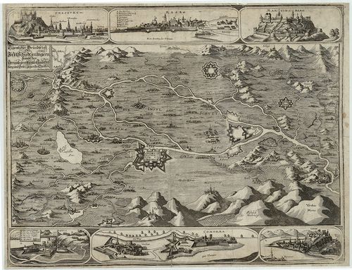
| Title | Eigentlicher Grundtriss der Insel Schiedt in Ungern Sambt den Herumbgrentzenten Haubtvestung und Orte gegenden Türken |
| Main title | 6 mt.: madártávl. 1. Pressburg (Pozsony–Bratislava,) 2. Raab (Győr) 3. Martinberg. (Pannonhalma) 4. Dotis (Tata) 5. Comorra (Komárom-Komarno) 6. Gran. (Esztergom) várak látképei és alaprajzai.Csallóköz és Szigetköz környéke a török hódoltság idején 1650-ben. |
232. Mappa Geometrica Oppidi Regio Coronalis Privilegati Szenta I... [S 11 - No. 612.]
National Archives of Hungary •
S 11 Kamarai térképek (1747-1882)
•
S Kormányhatósági fondokból kiemelt térképek (17. sz.-20. sz.)
•
S – Térképtár

| Main title | Mappa Geometrica Oppidi Regio Coronalis Privilegati Szenta Inclito Cottatui Bacsiensi ingremiatae exhibens quantitatem Vinearum sicuti et fassorum |
| Subject | No. 612. Szenta allodiális szőlőparcelláinak térképe /sok részletrajz/ |
Contributor: [...] Cottus Bacsiensis Ord Judlium Ballun Martinus Ejusdem I Cottus Ord Jurassor [...]
233. Illustrissimo nomini viri excelentissimi Samuelis a Bruckent... [T 15 - No. 36/II.]
National Archives of Hungary •
T 15 Vegyes tervrajzok (1778-1977)
•
T – Tervtár
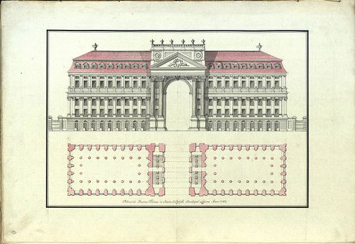
| Main title | Illustrissimo nomini viri excelentissimi Samuelis a Bruckenthal, Magni Tran[szlva]niae Pricipatuus gubernatoris c musarum Claudiopolitanarum fautoris, opera geometrico, architectonica suorum auditorum debita observantia, et veneratione inscribit P. Ignatius Malinovits E.S.P. |
| Subject | No. 36/II. Kolozsvári (ma Cluj-Napoca, RO) épületek tervrajzai /Kolozsvári iskolai hallgatók munkája/ |
Contributor: Majer Martinus Farkas Sam Keresztes Joannes Thallinger [...]
234. Ichonographia vineas in terris allodialium districtualium lo... [S 11 - No. 611.]
National Archives of Hungary •
S 11 Kamarai térképek (1747-1882)
•
S Kormányhatósági fondokból kiemelt térképek (17. sz.-20. sz.)
•
S – Térképtár

| Main title | Ichonographia vineas in terris allodialium districtualium locorum Földvár, Turia, V. Becse, Petrovoszelo et Mohol plantatas, considerata figura et orientatione, irreflexe ad earumdem ab invicem distantiam exhibens |
| Subject | No. 611. Földvár, Turia, V. Becse, Péterréve és Mohol allodiális szőlőparcelláinak térképe |
Contributor: [...] Cottus Bacsiensis Ord Judlium Ballun Martinus Ejusdem I Cottus Jurassor Bauer [...]
235. Mappa exhibens plagam inter terrenum praedii Minczend ex una... [S 98 - No. 5.]
National Archives of Hungary •
S 98 Eszterházy család csákvári ága (18. sz.-19. sz.)
•
S Családi fondokból kiemelt térképek (17. sz.-20. sz.)
•
S – Térképtár
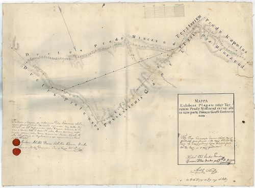
| Main title | Mappa exhibens plagam inter terrenum praedii Minczend ex una altera vero parte poonem Gánth controversam |
| Subject | No. 5. Gánt és Mindszentpuszta (Fejér m.) vitás határa |
Contributor: Mihálkó Martinus Dominii Csokakeő Ordinarius Fiscalis Miskey [...]
236. Plan und Profils über den zvischen Alt-und Neu-Kanisa längst... [S 11 - No. 1211.]
National Archives of Hungary •
S 11 Kamarai térképek (1747-1882)
•
S Kormányhatósági fondokból kiemelt térképek (17. sz.-20. sz.)
•
S – Térképtár

| Main title | Plan und Profils über den zvischen Alt-und Neu-Kanisa längst den Teiss-Ufer Neu errichteten Strassen Damm ... |
| Subject | No. 1211. A Tisza folyó Magyarkanizsa (Bács-Bodrog) és Törökkanizsa (Torontál m.) között, a tervezett gáttal |
Contributor: [...] Latinovics Theodor O Judlium Dancs Martinus Jurassor Quits Antonius Cottus Bacsiensis [...]
237. Mappa Oppidi Tamási [S 16 - No. 55.]
National Archives of Hungary •
S 16 Esterházy család hercegi ága (17. sz.-19. sz.)
•
S Családi fondokból kiemelt térképek (17. sz.-20. sz.)
•
S – Térképtár
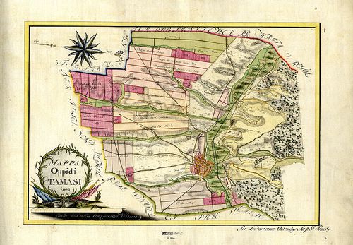
| Main title | Mappa Oppidi Tamási |
| Subject | No. 55. Tamási (Tolna m.) úrbéri térképe |
Content: [...] Kutak dűlője Öreg alasi rét Martincza Öreg vonalkázással jelölt domborzat Puszta [...] Content: [...] Kutak dűlője Öreg alasi rét Martincza Öreg vonalkázással jelölt domborzat Puszta [...]
238. Baranya megye Duna-Szekcső nagyközség [S 78 - 015. téka - Dunaszekcső - 25-76.]
National Archives of Hungary •
S 78 Térképek (1786-1948)
•
S Kataszteri-gyűjtemény (1786-1948)
•
S – Térképtár
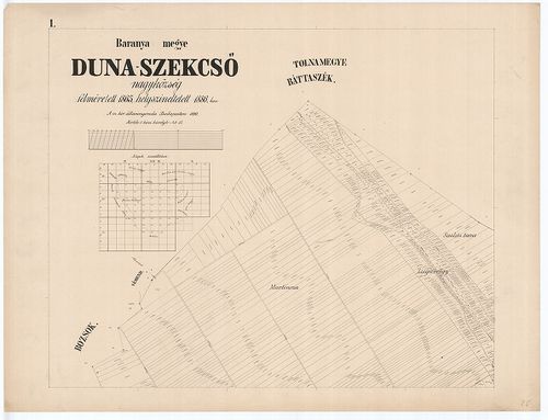
| Main title | Baranya megye Duna-Szekcső nagyközség |
| Subject | 015. téka - Dunaszekcső - 25-76. Dunaszekcső (Baranya m.) |
Content: Dunaszekcső Bozsok Vémend Báttaszék Martincza Zsigavölgy Saslits tava Szárazvölgy Herakmegye [...]
239. Mappa naturalem repraesentans situm praedii Dubrava ... [S 12 - Div. X. - No. 37.]
National Archives of Hungary •
S 12 Helytartótanácsi térképek (1738-1875)
•
S Kormányhatósági fondokból kiemelt térképek (17. sz.-20. sz.)
•
S – Térképtár

| Main title | Mappa naturalem repraesentans situm praedii Dubrava ... |
| Subject | Div. X. - No. 37. Dubrava praedium (Sáros m.) mezőgazdasági és erdőtérképe, valamint Zsegyne területén lévő egyes parcellák térképe |
Contributor: Zvolenszky Martinus dipl geometra
240. Dorf Szent Gál in Ungarn, Oedenburger Distrikt, Veszprimer C... [S 78 - 295. téka - Szentgál - 19-96.]
National Archives of Hungary •
S 78 Térképek (1786-1948)
•
S Kataszteri-gyűjtemény (1786-1948)
•
S – Térképtár

| Main title | Dorf Szent Gál in Ungarn, Oedenburger Distrikt, Veszprimer Comitat |
| Subject | 295. téka - Szentgál - 19-96. Szentgál (Veszprém m.) |
Contributor: Serschén A Grossauer Martin Geometra Lang Anton Geometra