1. G. Freytags Völkerkarte von Europa. [B I c 88]
Institute and Museum of Military History •
B I c
•
B I Európa
•
B I–XV. Európa
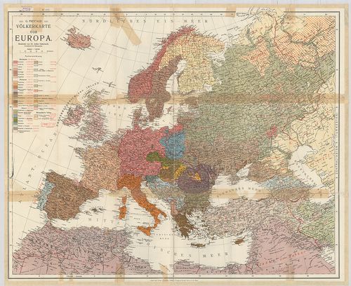
| Title | G. Freytags Völkerkarte von Europa. |
| Main title | Európa néprajzi térképe. |
2. Länder- und Völkerkarte Europas. [B I c 89]
Institute and Museum of Military History •
B I c
•
B I Európa
•
B I–XV. Európa
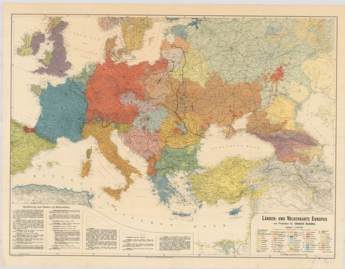
| Title | Länder- und Völkerkarte Europas. |
| Main title | Európa ország és néprajzi térképe. |
3. Europa etnografica. [B I c 94]
Institute and Museum of Military History •
B I c
•
B I Európa
•
B I–XV. Európa

| Title | Europa etnografica. |
| Main title | Európa néprajzi térképe 1940-ben. |
4. G. Freytags Karte: 1. Europas neue Staatengrenzen. 2. Etnogr... [B II a 71]
Institute and Museum of Military History •
B II a
•
B II Európa, nagyobb részek és országcsoportok
•
B I–XV. Európa
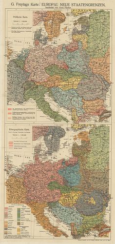
| Title | G. Freytags Karte: 1. Europas neue Staatengrenzen. 2. Etnographische Karte. |
| Main title | 1. Közép-Európa politikai térképe az új határokkal. 2. Közép-Európa néprajzi térképe. |
5. A Duna-medence és szomszédos országok néprajzi térképe. [B II c 81]
Institute and Museum of Military History •
B II c
•
B II Európa, nagyobb részek és országcsoportok
•
B I–XV. Európa
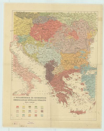
| Title | A Duna-medence és szomszédos országok néprajzi térképe. |
6. Ethnographische Übersichts des Europäischer Orients. 1876. [B II c 84]
Institute and Museum of Military History •
B II c
•
B II Európa, nagyobb részek és országcsoportok
•
B I–XV. Európa
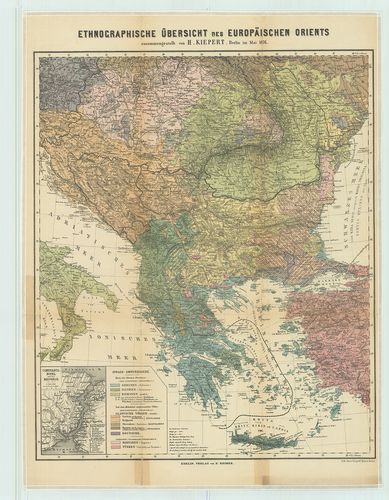
| Title | Ethnographische Übersichts des Europäischer Orients. 1876. |
| Main title | Mt.: Constantinopel u. der Bosporus. |
| Subject | (Istanbul és a Boszporusz) |
Content: Kelet Európa néprajzi térképe 1876 ban
7. Carte ethnographique de L’Europe Centrale. [B II c 105]
Institute and Museum of Military History •
B II c
•
B II Európa, nagyobb részek és országcsoportok
•
B I–XV. Európa
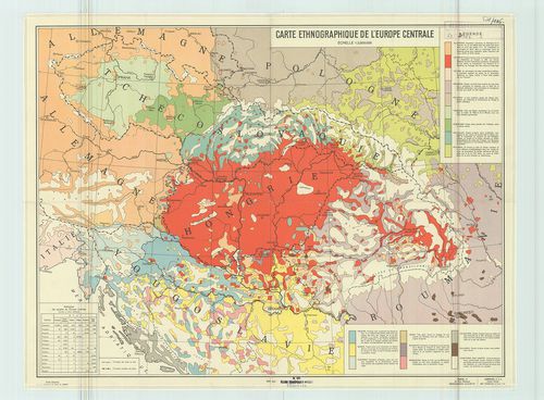
| Title | Carte ethnographique de L’Europe Centrale. |
| Main title | Közép-Európa néprajzi térképe 1938-ban. |
8. A dunai államok néprajzi térképe. [B II c 106]
Institute and Museum of Military History •
B II c
•
B II Európa, nagyobb részek és országcsoportok
•
B I–XV. Európa
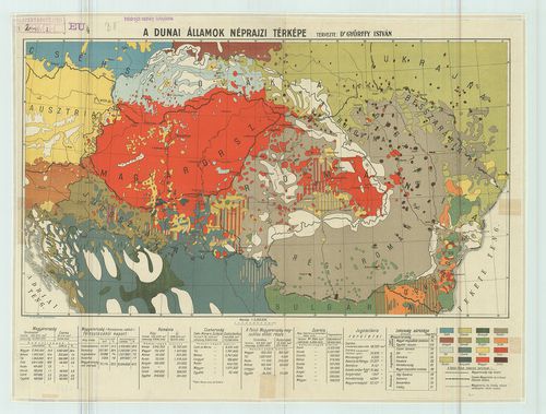
| Title | A dunai államok néprajzi térképe. |
9. Carte Ethnographique des pays Danubiens. [B II c 213]
Institute and Museum of Military History •
B II c
•
B II Európa, nagyobb részek és országcsoportok
•
B I–XV. Európa
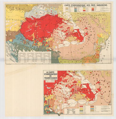
| Title | Carte Ethnographique des pays Danubiens. |
| Main title | Mt. La Carte Ethnographique de Transylvanie. (Erdély néprajzi térképe. |
| Subject | A Duna-medence néprajzi térképe 1928 körül. |
10. A moldvai csángók néprajzi térképe. – Carte Ethnographique d... [B III c 103]
Institute and Museum of Military History •
B III c
•
B III Balkán-félsziget
•
B I–XV. Európa
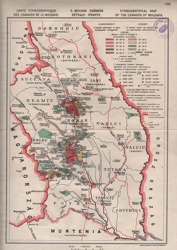
| Title | A moldvai csángók néprajzi térképe. – Carte Ethnographique des Csángós de la Moldavie. – Ethnographical map of the Csángos of Moldvia. |
11. Die Albaner. [B III c 120]
Institute and Museum of Military History •
B III c
•
B III Balkán-félsziget
•
B I–XV. Európa

| Title | Die Albaner. |
| Main title | Albánia néprajzi és felekezeti térképe az 1910-es években. |
12. Italien. Flemmings Generalkarten. Nr. 18. [B VII a 481]
Institute and Museum of Military History •
B VII a
•
B VII Olaszország
•
B I–XV. Európa
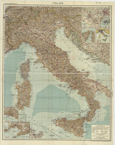
| Title | Italien. Flemmings Generalkarten. Nr. 18. |
| Main title | 8 mt.: 1. [Róma és környéke.] |
| Subject | 2. [Róma.] |
Content: 4 Néprajzi térk Content: Olaszország általános térképe 1918 körül
13. Der Osterreichische Kaiserstaat. [B IX a 18]
Institute and Museum of Military History •
B IX a
•
B IX Ausztria–Magyarország
•
B I–XV. Európa
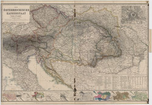
| Title | Der Osterreichische Kaiserstaat. |
| Main title | 10 mt. 1. Wien. (Bécs várostérk.) 2. Hydrographische Skizze von Österreich. (Vízrajzi térk.) 3. Orographische Skizze v. Österreich. (Hegyrajzi térk.) 4. Geologische Skizze v. Österreich. (Geológiai térk.) 5. Klimatographische Skizze v. Österreich. (Éghajlat térk.) 6. Hyetographische Skizze v. Österreich. (Csapadék térk.) 7. Volksdichtigkeit Öst. (Népsűrűség.) 8. Ethnographie Öst. (Néprajzi térk.) 9. Religionen Öst. (Felekezeti térk.) 10. Kultur und Industrie Öst. (Gazdasági térk.) |
| Subject | Az Osztrák Császárság térképe 1863-ban. |
14. Mappa Generalis Topographico-Ecclesiastico-Ethnographico-Sta... [B IX a 506]
Institute and Museum of Military History •
B IX a
•
B IX Ausztria–Magyarország
•
B I–XV. Európa
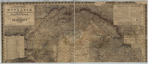
| Title | Mappa Generalis Topographico-Ecclesiastico-Ethnographico-Statistica Regni Hungariae partiumque adnexarum Croatieae Slavoniae et Confiniorum Militarium Magni item Principatus Transylvaniae. |
| Main title | A Magyar Királyság, Horvát-Szlavónia , a Katonai Határőrvidékek és Erdély általános topográfiai, egyházmegyei, néprajzi, statisztikai térképe 1830–1840-ben. |
15. I. Kolozs vármegye néprajzi térképe a Hunyadiak korában. [B IX a 1831]
Institute and Museum of Military History •
B IX a 1401–2599 Magyarország megyetérképek
•
B IX Ausztria–Magyarország
•
B I–XV. Európa
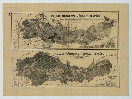
| Title | I. Kolozs vármegye néprajzi térképe a Hunyadiak korában. |
| Main title | II. Kolozs vármegye néprajzi térképe az 1910. évi népszámlálás alapján. |
16. Sopron vármegye. iskolai és közigazgatási falitérképe. [B IX a 2070]
Institute and Museum of Military History •
B IX a 1401–2599 Magyarország megyetérképek
•
B IX Ausztria–Magyarország
•
B I–XV. Európa

| Title | Sopron vármegye. iskolai és közigazgatási falitérképe. |
| Main title | 2 mt. 1. Sopron szabad királyi város tervrajza. 2. Sopron vármegye néprajzi térképe. |
17. Carte ethnographique du royaume de Hongrie. [B IX c 101]
Institute and Museum of Military History •
B IX c
•
B IX Ausztria–Magyarország
•
B I–XV. Európa
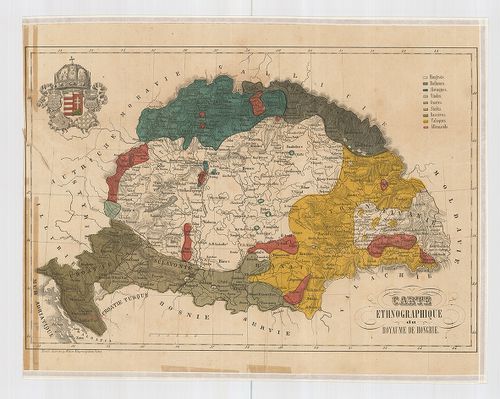
| Title | Carte ethnographique du royaume de Hongrie. |
| Main title | Magyarország néprajzi térképe 1870 körül. |
18. Versuch einer Sprachenkarte der Österreichischen Monarchie. [B IX c 118]
Institute and Museum of Military History •
B IX c
•
B IX Ausztria–Magyarország
•
B I–XV. Európa
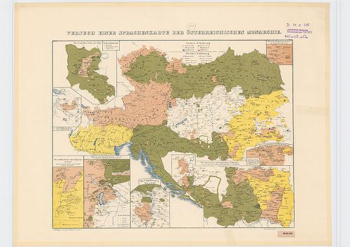
| Title | Versuch einer Sprachenkarte der Österreichischen Monarchie. |
| Main title | 1. Ethnographische Übersicht. (Néprajzi áttekintő.) 2. füz. 9 p. szöv. magy. a térképhez. 8 mt. 1. Die Deutschen Orte der Zips. (A szepességi németek.) 2. Die Walser-Orte in Vorarlberg. (A walserek a Vorarlbergben.) 3. Die süddeutsche Sprachgrenze in Tirol und die deutschen Gemeinden südlich derselben. (A tiroli D-német nyelvhatár és német községek.) 4. Die zerstreuten Kroaten-Orte in Österreich, Mähren und Ungarn. (A szétszórt horvátok, Ausztriában, Morvaországban és Magyarországban.) 5. Die Umgebung von Ofen und Pesth. (Pest és Buda környéke.) 6. Die deutschen (schwäbischen) Colonien in der Comitaten Tolna, Baranya, Bács und in Banate. (A német [sváb] települések Tolna, Baranya, Bács megyében és a Bánságban.) 7. Die Umgebung von Hermannstadt. (Sibiu] környéke.) 8. Die rein sächsischen Orte im Bistritzer Bezirk. (A szászok a Besztercei kerületben.) |
| Subject | Az Osztrák Monarchia nemzetiségi térképe 1846-ból. |
19. Ethnographische Karte des Königreichs Ungarn. [B IX c 118/1]
Institute and Museum of Military History •
B IX c
•
B IX Ausztria–Magyarország
•
B I–XV. Európa
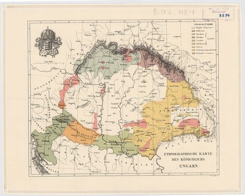
| Title | Ethnographische Karte des Königreichs Ungarn. |
| Main title | Magyarország néprajzi térképe 1846 körül. |
20. Sprachen Karte der Österreichischen Monarchie. [B IX c 119]
Institute and Museum of Military History •
B IX c
•
B IX Ausztria–Magyarország
•
B I–XV. Európa
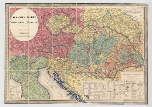
| Title | Sprachen Karte der Österreichischen Monarchie. |
| Main title | Az Osztrák Monarchia néprajzi térképe 1848 körül. |