1. Erdély néprajzi térképe. [B XV c 464]
Institute and Museum of Military History •
B XV c
•
B XV Magyarország (1920 után)
•
B I–XV. Európa
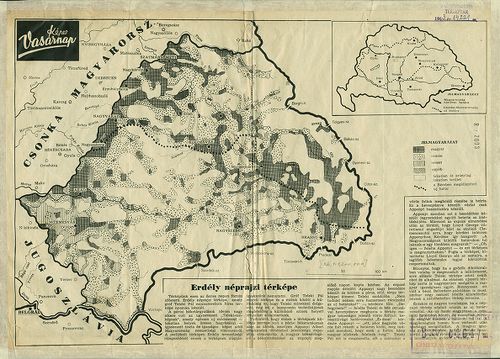
| Title | Erdély néprajzi térképe. |
| Main title | 1 mt.: [Magyarország. |
Technical features: Készült Teleki Pál néprajzi térképe alapján Képes Vasárnap c újság [...]
2. I. Kolozs vármegye néprajzi térképe a Hunyadiak korában. [B IX a 1831]
Institute and Museum of Military History •
B IX a 1401–2599 Magyarország megyetérképek
•
B IX Ausztria–Magyarország
•
B I–XV. Európa
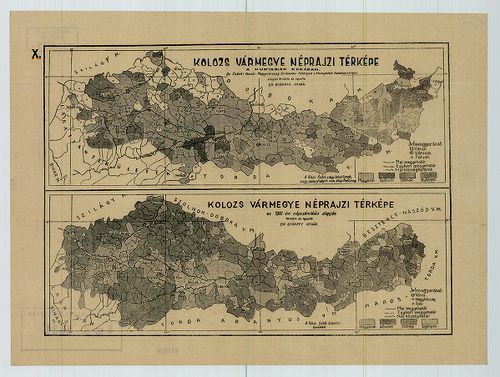
| Title | I. Kolozs vármegye néprajzi térképe a Hunyadiak korában. |
| Main title | II. Kolozs vármegye néprajzi térképe az 1910. évi népszámlálás alapján. |
3. Erdélynek és Magyarország keleti részeinek néprajzi térképe ... [B XV c 466]
Institute and Museum of Military History •
B XV c
•
B XV Magyarország (1920 után)
•
B I–XV. Európa
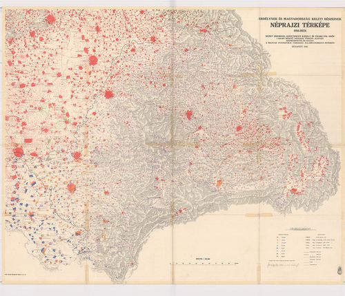
| Title | Erdélynek és Magyarország keleti részeinek néprajzi térképe 1910-ben. Bátky Zs.–Kogutowicz K.–Teleki Pál, 1:200 000-es néprajzi térképe alapján. |
4. Carte Ethnographique des pays Danubiens. [B II c 213]
Institute and Museum of Military History •
B II c
•
B II Európa, nagyobb részek és országcsoportok
•
B I–XV. Európa
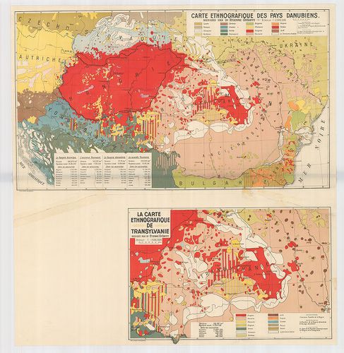
| Title | Carte Ethnographique des pays Danubiens. |
| Main title | Mt. La Carte Ethnographique de Transylvanie. (Erdély néprajzi térképe. |
| Subject | A Duna-medence néprajzi térképe 1928 körül. |
5. Magyarország néprajzi térképe az 1910. évi népszámlálás adat... [B IX c 1041]
Institute and Museum of Military History •
B IX c
•
B IX Ausztria–Magyarország
•
B I–XV. Európa
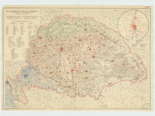
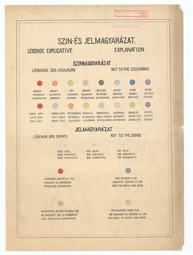
| Title | Magyarország néprajzi térképe az 1910. évi népszámlálás adatainak alapján. – Ethnographical Map of Hungary. – Carte Ethnographique de la Hongrie. |
| Main title | Mt. [Budapest néprajzi térképe.] |
6. [Magyarország.]: néprajzi térképe. [B IX c 1083]
Institute and Museum of Military History •
B IX c
•
B IX Ausztria–Magyarország
•
B I–XV. Európa
| Title | [Magyarország.]: néprajzi térképe. |
7. Ethnographische Übersichts des Europäischer Orients. 1876. [B II c 84]
Institute and Museum of Military History •
B II c
•
B II Európa, nagyobb részek és országcsoportok
•
B I–XV. Európa
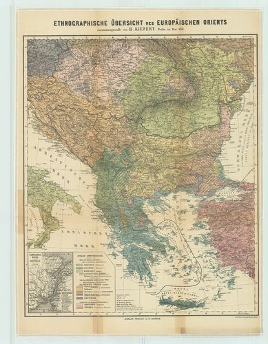
| Title | Ethnographische Übersichts des Europäischer Orients. 1876. |
| Main title | Mt.: Constantinopel u. der Bosporus. |
| Subject | (Istanbul és a Boszporusz) |
Content: Kelet Európa néprajzi térképe 1876 ban
8. A moldvai csángók néprajzi térképe [TK 1380]
National Széchényi Library •
OSZK kéziratos térképek
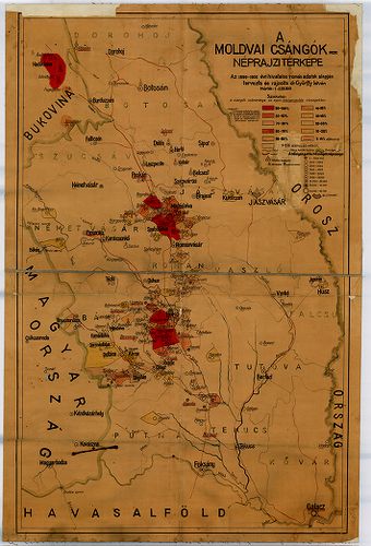
| Title | A moldvai csángók néprajzi térképe |
9. A dunai államok néprajzi térképe. [B II c 106]
Institute and Museum of Military History •
B II c
•
B II Európa, nagyobb részek és országcsoportok
•
B I–XV. Európa
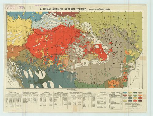
| Title | A dunai államok néprajzi térképe. |
10. Kisfalud község 1864. évben felosztott urbéri erdőilletékről... [TK 957]
National Széchényi Library •
OSZK kéziratos térképek
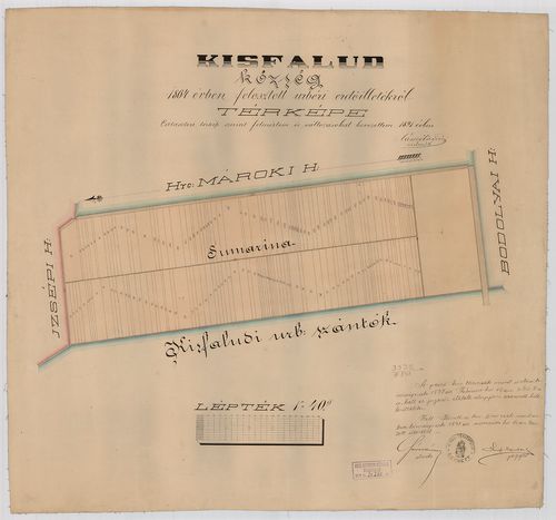
| Title | Kisfalud község 1864. évben felosztott urbéri erdőilletékről térképe |
Content: [...] dűlők névvel Keret nélkül Proven Néprajzi Múzeum
11. Völker- und Sprachenkarte von Österreich–Ungarn. [B IX c 125/2]
Institute and Museum of Military History •
B IX c
•
B IX Ausztria–Magyarország
•
B I–XV. Európa
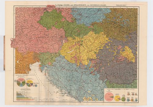
| Title | Völker- und Sprachenkarte von Österreich–Ungarn. |
| Main title | Az Osztrák–Magyar Monarchia néprajzi és nyelvi térképe. |
Technical features: [...] Karte A Világkereskedelem és közlekedés térképe
12. Kisfalud helység határának térképe [TK 1577]
National Széchényi Library •
OSZK kéziratos térképek

| Title | Kisfalud helység határának térképe |
Content: [...] művelési ágak színnel Színmagyarázat Proven Néprajzi Múzeum
13. Baranyavár község 1864. évben felosztott erdőilletékekről té... [TK 1566]
National Széchényi Library •
OSZK kéziratos térképek

| Title | Baranyavár község 1864. évben felosztott erdőilletékekről térképe |
Content: [...] bejelölve Felosztott parcellák számmal Proven Néprajzi Múzeum
14. Kapornak térképe [TK 981]
National Széchényi Library •
OSZK kéziratos térképek

| Title | Kapornak térképe |
Content: [...] részeik betűvel ill számmal Proven Néprajzi Múzeum
15. Medvei határ térképe [TK 1766]
National Széchényi Library •
OSZK kéziratos térképek

| Title | Medvei határ térképe |
Content: [...] ágak színnel Dűlők névvel Proven Néprajzi Múzeum
16. Áttekintési térképe a' rohonczi határnak [TK 988]
National Széchényi Library •
OSZK kéziratos térképek
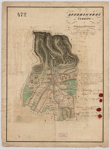
| Title | Áttekintési térképe a' rohonczi határnak |
Content: [...] ágak színnel dűlők névvel Proven Néprajzi Múzeum
17. Bellye helység beltekeinek és az ugy nevezett lenföldeknek e... [TK 976]
National Széchényi Library •
OSZK kéziratos térképek

| Title | Bellye helység beltekeinek és az ugy nevezett lenföldeknek egyénenkínti részletes térképe |
Content: [...] adattal épületek alaprajzban 17 Proven Néprajzi Múzeum
18. A Herceg-mároki úrbérileg szabályozott határ kiegészítő rész... [TK 806]
National Széchényi Library •
OSZK kéziratos térképek

| Title | A Herceg-mároki úrbérileg szabályozott határ kiegészítő részének térképe |
Content: [...] Dűlők névvel Keret nélkül Proven Néprajzi Múzeum
19. Eugénfalu helység határának térképe [TK 815]
National Széchényi Library •
OSZK kéziratos térképek

| Title | Eugénfalu helység határának térképe |
Content: [...] 21 ill 1874 ápr Proven Néprajzi Múzeum 9
20. Boró helység határának térképe [TK 1788]
National Széchényi Library •
OSZK kéziratos térképek

| Title | Boró helység határának térképe |
Content: [...] ágak színnel Dűlők névvel Proven Néprajzi Múzeum