261. Principatus Transilvaniae in suas quosque Nationes earumque ... [B IX a 706]
Institute and Museum of Military History •
B IX a
•
B IX Ausztria–Magyarország
•
B I–XV. Európa
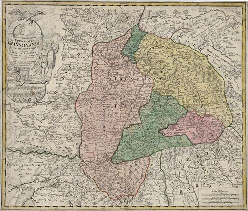
| Title | Principatus Transilvaniae in suas quosque Nationes earumque Sedes et Regiones cum finitimis vicinorum Statuum provinciis accurate divisus… |
| Main title | Erdély térképe a 18. század elején. |
262. Magni principatus Transylvaniae tabula ex archetypo 1751 . [TK 2058]
National Széchényi Library •
OSZK kéziratos térképek
| Title | Magni principatus Transylvaniae tabula ex archetypo 1751 . |
Content: Erdély Fokhálózat a kereten bejelölve Domborzat [...]
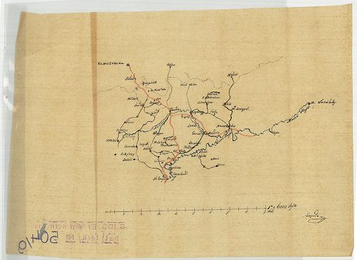
263. Charte von Marmaros [S 101 - No. 223.]
National Archives of Hungary •
S 101 Abszolutizmuskori térképek (1849-1867)
•
S Kormányhatósági fondokból kiemelt térképek (17. sz.-20. sz.)
•
S – Térképtár
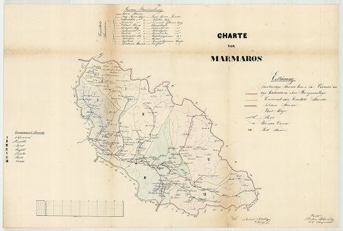
| Main title | Charte von Marmaros |
| Subject | No. 223. Máramaros megye |
Content: országhatár Galícia Erdély Bukovina megyehatárok Máramaros Bereg Ugocsa [...]
264. More Important settlings in Today’s area of Transylvania. Di... [B XV c 427]
Institute and Museum of Military History •
B XV c
•
B XV Magyarország (1920 után)
•
B I–XV. Európa
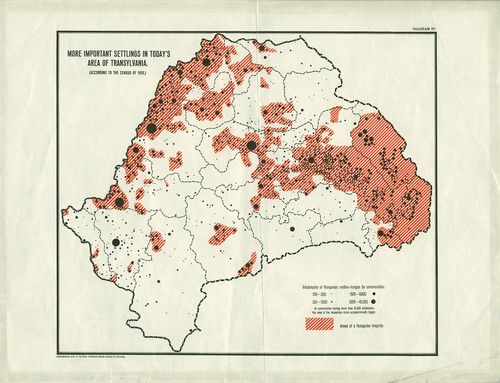
| Title | More Important settlings in Today’s area of Transylvania. Diagram IV. (According To the census of 1910.) |
Technical features: 23 20 cm Szín Erdély magyarlakta területei
265. Új Posta Mappája Magyar és Erdély Országoknak a’ posták legú... [B IX c 625]
Institute and Museum of Military History •
B IX c
•
B IX Ausztria–Magyarország
•
B I–XV. Európa
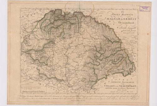
| Title | Új Posta Mappája Magyar és Erdély Országoknak a’ posták legújabb elintézések szerént. – Neueste Postkarte von Ungarn und Siebenbürgen nach dem genau revidierten Postwesen dieser Länder. |
266. Carte de la Valachie et de la Moldavie comprenant aussi la B... [B III a 160]
Institute and Museum of Military History •
B III a
•
B III Balkán-félsziget
•
B I–XV. Európa
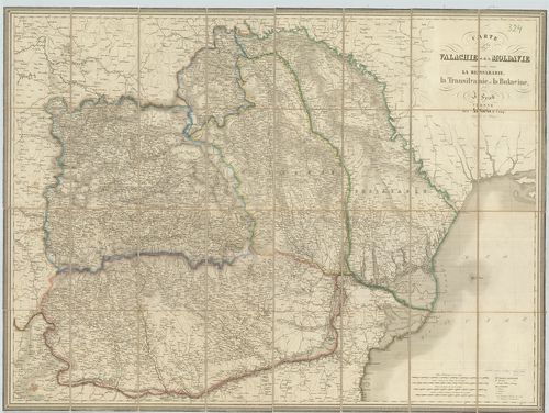
| Title | Carte de la Valachie et de la Moldavie comprenant aussi la Bessarabie, la Transilvanie et la Bukovine. |
| Main title | Havasalföld, Moldva, Besszarábia, Erdély és Bukovina térképe. |
267. Transylvaniae, Moldaviae, Walachiae, Bulgariae nova et accur... [S 68 - X. - No. 74.]
National Archives of Hungary •
S 68 Festetics család (1645-1943)
•
S Családi fondokból kiemelt térképek (17. sz.-20. sz.)
•
S – Térképtár
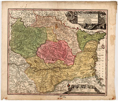
| Main title | Transylvaniae, Moldaviae, Walachiae, Bulgariae nova et accurata delineatio, magnam partem hodierni theatri bellici ob oculos ponens |
| Subject | X. - No. 74. Erdély, Moldva, Havasalföld, Bulgária |
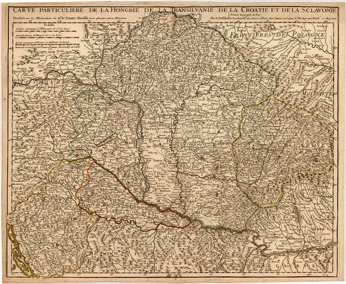
268. Carte Particuliere de la Hongrie de la Transilvanie de la Cr... [B IX a 539/1]
Institute and Museum of Military History •
B IX a
•
B IX Ausztria–Magyarország
•
B I–XV. Európa
| Title | Carte Particuliere de la Hongrie de la Transilvanie de la Croatie et de la Sclavonie. |
| Main title | Magyarország, Erdély, Horvát-Szlavónia térképe 1717-ben, tartományi határszínezés. |
269. Carte particuliere de la Hongrie de la Transilvanie de la Cr... [S 68 - X. - No. 59.]
National Archives of Hungary •
S 68 Festetics család (1645-1943)
•
S Családi fondokból kiemelt térképek (17. sz.-20. sz.)
•
S – Térképtár
| Main title | Carte particuliere de la Hongrie de la Transilvanie de la Croatie et de la Sclavonie |
| Subject | X. - No. 59. Magyarország, Erdély, Horvátország és Szlavónia |
270. Orts- und Strassenkarte des Königreiches Ungarn (mit inbegri... [B IX c 620]
Institute and Museum of Military History •
B IX c
•
B IX Ausztria–Magyarország
•
B I–XV. Európa
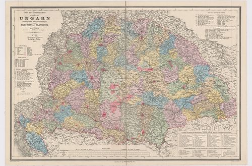
| Title | Orts- und Strassenkarte des Königreiches Ungarn (mit inbegriff des ehemaligen Siebenbürgen) nebst Kroatien und Slavonien. |
| Main title | Magyarország, Erdély, Horvát-Szlavónia település és úttérképe 1882-ben. |
271. Le Royaume de Hongrie divisé en Haute et Basse Hongrie, Tran... [B IX a 490/2]
Institute and Museum of Military History •
B IX a
•
B IX Ausztria–Magyarország
•
B I–XV. Európa
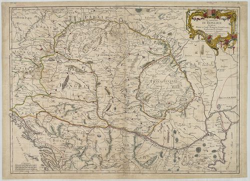
| Title | Le Royaume de Hongrie divisé en Haute et Basse Hongrie, Transilvanie, Esclavonie et Croatie. |
| Main title | A Magyar Királyság, Erdély és Horvát-Szlavónia térképe 1759-ben. |
272. Orts- und Strassenkarte des Königreiches Ungarn (mit inbegri... [B IX c 620/1]
Institute and Museum of Military History •
B IX c
•
B IX Ausztria–Magyarország
•
B I–XV. Európa
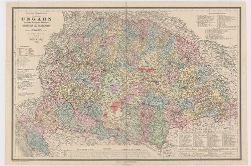
| Title | Orts- und Strassenkarte des Königreiches Ungarn (mit inbegriff des ehemaligen Siebenbürgen) nebst Kroatien und Slavonien. |
| Main title | Magyarország, Erdély, Horvát-Szlavónia település és úttérképe 1887-ben. |
273. No. 504/9. Az erdélyi IX. sz. építési körzet [S 105 - No. 504/9.]
National Archives of Hungary •
S 105 Erdélyi kormányhatósági levéltárból kiemelt térképek (1798-1868)
•
S Kormányhatósági fondokból kiemelt térképek (17. sz.-20. sz.)
•
S – Térképtár
| Subject | No. 504/9. Az erdélyi IX. sz. építési körzet |
274. Strassen Karte des Grossfürstenthums Siebenbürgen. Die zur M... [B IX c 420]
Institute and Museum of Military History •
B IX c
•
B IX Ausztria–Magyarország
•
B I–XV. Európa
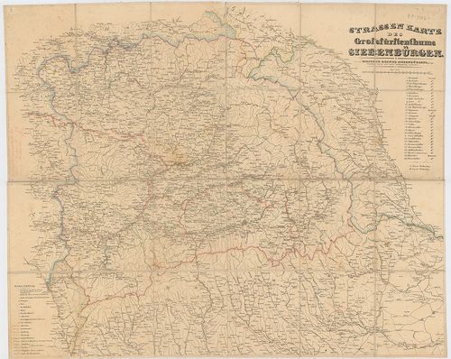
| Title | Strassen Karte des Grossfürstenthums Siebenbürgen. Die zur Militair Grenze Siebenbürgens gehőrigen Ortschaften sind mit einer andern Schiftgattung beschrieben. |
| Main title | Erdély úttérképe az oda tartozó katonai határőrvidékkel. |
275. Tabula generalis Regni Hungariae, Croatiae et Slavoniae nec ... [B IX a 1205]
Institute and Museum of Military History •
B IX a
•
B IX Ausztria–Magyarország
•
B I–XV. Európa
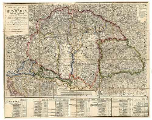
| Title | Tabula generalis Regni Hungariae, Croatiae et Slavoniae nec non Magni Principatus Transylvaniae… |
| Main title | A Magyar Királyság, Horvát-Szlavónia és Erdély általános térképe 1848-ban. Tartományi színezés. |
276. Politische Einteilung, Städte, Märkte, Bevölkerungsdichte un... [B IX c 422]
Institute and Museum of Military History •
B IX c
•
B IX Ausztria–Magyarország
•
B I–XV. Európa
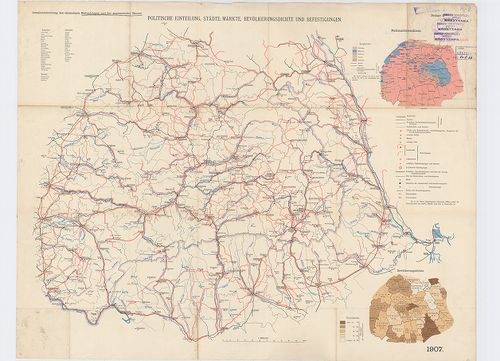
| Title | Politische Einteilung, Städte, Märkte, Bevölkerungsdichte und Befestigungen. |
| Main title | 2 mt. 1. Nationalitätenskizze. (Nemzetiségi vázlat.) 2. Bevölkerungsdichte. (Népsűrűség.) |
| Subject | Erdély politikai beosztása, települései, erődített helyei 1907-ben. |
277. Magyarország néprajzi térképe. – Carte Ethnographique de la ... [B IX c 1074/1]
Institute and Museum of Military History •
B IX c
•
B IX Ausztria–Magyarország
•
B I–XV. Európa
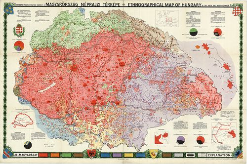
| Title | Magyarország néprajzi térképe. – Carte Ethnographique de la Hongrie. |
| Main title | 4 mt.: 1. A magyar szent korona országai. 2. [Magyarország elhelyezkedése Európába.] 3. K-Poroszország. 4. Erdély. |
278. Post Karte der Kronländer Ungarn, Siebenbürgen, Croatien. Sl... [B IX c 40]
Institute and Museum of Military History •
B IX c
•
B IX Ausztria–Magyarország
•
B I–XV. Európa
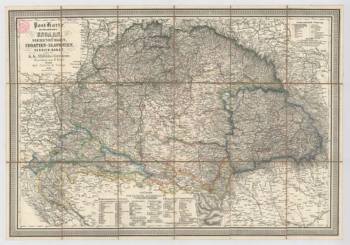
| Title | Post Karte der Kronländer Ungarn, Siebenbürgen, Croatien. Slavonien, Serbien-Banat nebst der k. k. Militär-Grenze. |
| Main title | Magyarország, Erdély, Horvát-Szlavonia, Szerb Bánság, Katonai Határőrvidék postatérképe. |
279. Tabula generalis Regni Hungariae Croatiae et Slavoniae nec n... [S 12 - Div. X. - No. 41.]
National Archives of Hungary •
S 12 Helytartótanácsi térképek (1738-1875)
•
S Kormányhatósági fondokból kiemelt térképek (17. sz.-20. sz.)
•
S – Térképtár
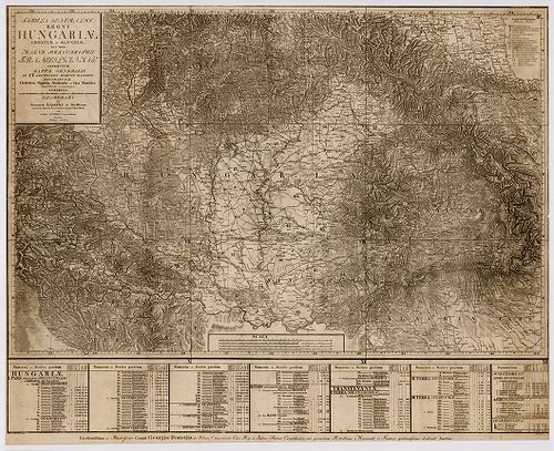
| Main title | Tabula generalis Regni Hungariae Croatiae et Slavoniae nec non Magni Principatus Transylvanias conspectum ... |
| Subject | Div. X. - No. 41. Magyarország, Horvátország és Szlavónia, valamint Erdély térképe |
280. Tabula generalis Regni Hungariae, Croatiae et Slavoniae nec ... [B IX a 500]
Institute and Museum of Military History •
B IX a
•
B IX Ausztria–Magyarország
•
B I–XV. Európa
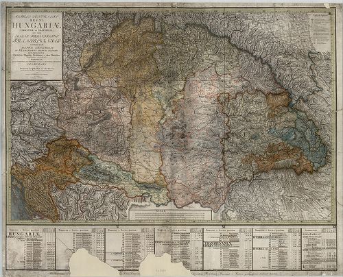
| Title | Tabula generalis Regni Hungariae, Croatiae et Slavoniae nec non Magni Principatus Transylvaniae… |
| Main title | A Magyar Királyság, Horvát-Szlavónia és Erdély általános térképe 1810-ben. Tartományi színezés. |