41. Ethnographische Karte des Königreichs Ungarn. [B IX c 118/1]
Institute and Museum of Military History •
B IX c
•
B IX Ausztria–Magyarország
•
B I–XV. Európa
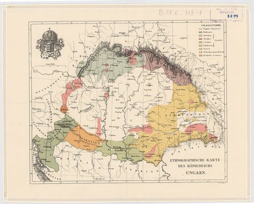
| Title | Ethnographische Karte des Königreichs Ungarn. |
| Main title | Magyarország néprajzi térképe 1846 körül. |
42. Grundriss der Haubt-residenz und Krőnungs-Statt Presburg in ... [TK 470]
National Széchényi Library •
OSZK kéziratos térképek
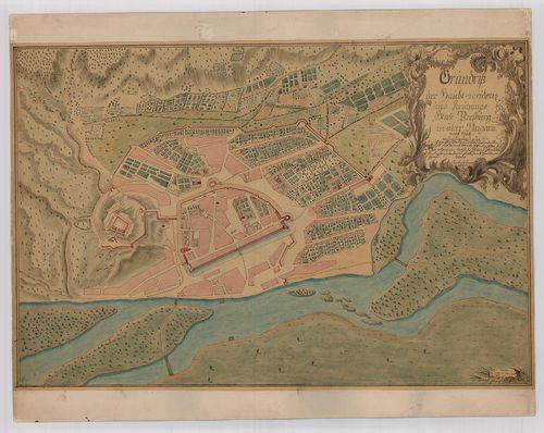
| Title | Grundriss der Haubt-residenz und Krőnungs-Statt Presburg in ober Ungarn |
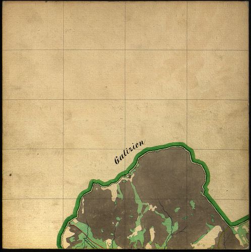
43. Karte von Ungarn und Galizien [S 68 - XIII. - No. 61.]
National Archives of Hungary •
S 68 Festetics család (1645-1943)
•
S Családi fondokból kiemelt térképek (17. sz.-20. sz.)
•
S – Térképtár
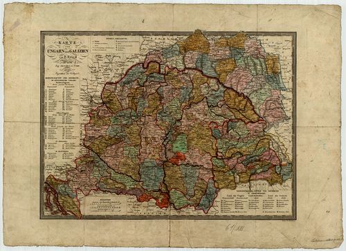
| Main title | Karte von Ungarn und Galizien |
| Subject | XIII. - No. 61. Magyarország, Galícia |
44. Eisenbahnkarte von Österreich–Ungarn. [B IX c 21/1]
Institute and Museum of Military History •
B IX c
•
B IX Ausztria–Magyarország
•
B I–XV. Európa
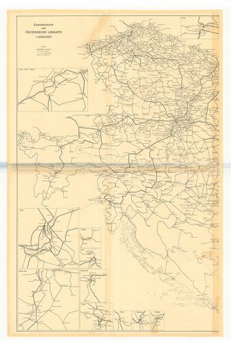
| Title | Eisenbahnkarte von Österreich–Ungarn. |
| Main title | Az Osztrák–Magyar Monarchia vasúttérképe 1914-ben. |
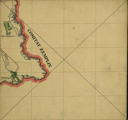
45. Kronland Ungarn Comitat Zemplén [S 78 - Zemplén m. - 001-118.]
National Archives of Hungary •
S 78 Térképek (1786-1948)
•
S Kataszteri-gyűjtemény (1786-1948)
•
S – Térképtár
| Main title | Kronland Ungarn Comitat Zemplén |
| Subject | Zemplén m. - 001-118. Zemplén m. |
46. Carte von Ungarn und Siebenbürgen. [B IX a 1201]
Institute and Museum of Military History •
B IX a
•
B IX Ausztria–Magyarország
•
B I–XV. Európa
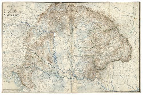
| Title | Carte von Ungarn und Siebenbürgen. |
| Main title | A Magyar Királyság és Erdély térképe. |
47. Postkarte von Ungarn und Siebenbürgen. [B IX c 1380]
Institute and Museum of Military History •
B IX c
•
B IX Ausztria–Magyarország
•
B I–XV. Európa
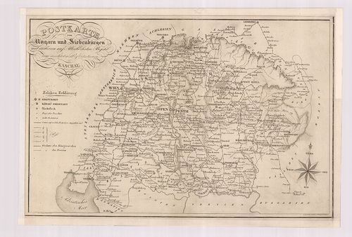
| Title | Postkarte von Ungarn und Siebenbürgen. |
| Main title | Magyarország és Erdély postatérképe 1826-ban. |
48. Kronland Ungarn Comitat Abauj [S 78 - Abaúj m. - 001-004.]
National Archives of Hungary •
S 78 Térképek (1786-1948)
•
S Kataszteri-gyűjtemény (1786-1948)
•
S – Térképtár
| Main title | Kronland Ungarn Comitat Abauj |
| Subject | Abaúj m. - 001-004. Abaúj m. |
49. Carte von Ungarn und Siebenbürgen. [B IX a 1202]
Institute and Museum of Military History •
B IX a
•
B IX Ausztria–Magyarország
•
B I–XV. Európa
| Title | Carte von Ungarn und Siebenbürgen. |
| Main title | A Magyar Királyság és Erdély térképe. |
50. Gemeinde Bogád in Ungarn... [S 78 - 010. téka - Bogád - 3.]
National Archives of Hungary •
S 78 Térképek (1786-1948)
•
S Kataszteri-gyűjtemény (1786-1948)
•
S – Térképtár
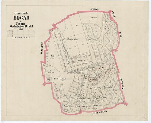
| Main title | Gemeinde Bogád in Ungarn... |
| Subject | 010. téka - Bogád - 3. Bogád (Baranya m.) |
51. Gemeinde Gerde in Ungarn... [S 78 - 017. téka - Gerde - 1.]
National Archives of Hungary •
S 78 Térképek (1786-1948)
•
S Kataszteri-gyűjtemény (1786-1948)
•
S – Térképtár
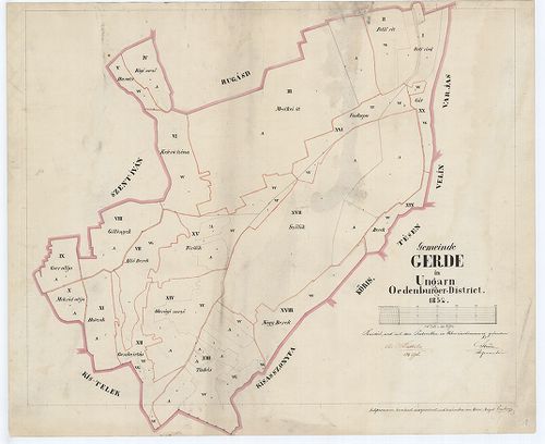
| Main title | Gemeinde Gerde in Ungarn... |
| Subject | 017. téka - Gerde - 1. Gerde (Baranya m.) |
52. Dislocations Carte von Ungarn de Anno 1781. [B IX c 685]
Institute and Museum of Military History •
B IX c
•
B IX Ausztria–Magyarország
•
B I–XV. Európa
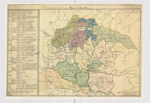
| Title | Dislocations Carte von Ungarn de Anno 1781. |
| Main title | Magyarország diszlokációs térképe 1781-ben. |
53. Dorf Alt Beznócz hiezu einverleibt Neu Beznócz in Ungarn Eis... [TK 440]
National Széchényi Library •
OSZK kéziratos térképek
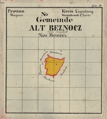
| Title | Dorf Alt Beznócz hiezu einverleibt Neu Beznócz in Ungarn Eisenburger Comitat Steueramt Olsnitz |
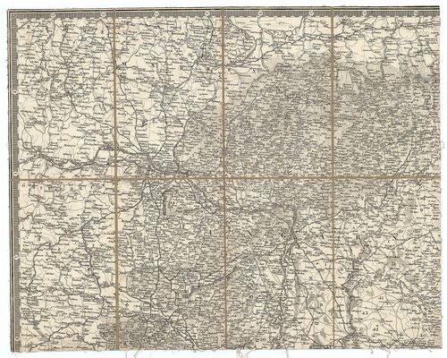
54. Specialkarte des Königreiches Ungarn. [B IX a 531/1]
Institute and Museum of Military History •
B IX a
•
B IX Ausztria–Magyarország
•
B I–XV. Európa
| Title | Specialkarte des Königreiches Ungarn. |
| Main title | Magyarország részletes térképe a II. katonai felmérés alapján.. |
55. Gemeinde Szárász in Ungarn.. [S 78 - 040. téka - Szárász - 1.]
National Archives of Hungary •
S 78 Térképek (1786-1948)
•
S Kataszteri-gyűjtemény (1786-1948)
•
S – Térképtár
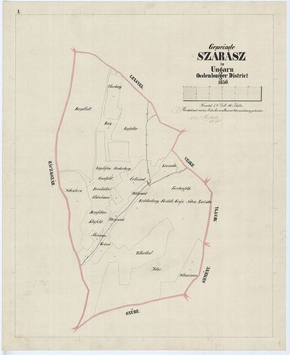
| Main title | Gemeinde Szárász in Ungarn.. |
| Subject | 040. téka - Szárász - 1. Szárász (Baranya m.) |
56. Eisenbahnkarte von Deutschland und Österreich–Ungarn. [B II c 156]
Institute and Museum of Military History •
B II c
•
B II Európa, nagyobb részek és országcsoportok
•
B I–XV. Európa
| Title | Eisenbahnkarte von Deutschland und Österreich–Ungarn. |
| Main title | Németország és Ausztria–Magyarország vasúti térképe. |
57. Aufnahme von der Marmorosch in Ober Ungarn. [B IX a 1340]
Institute and Museum of Military History •
B IX a
•
B IX Ausztria–Magyarország
•
B I–XV. Európa
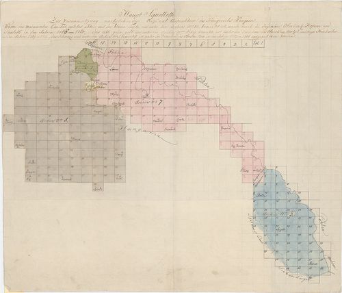
| Title | Aufnahme von der Marmorosch in Ober Ungarn. |
| Main title | Máramaros I. katonai felmérése (részfelmérés). |
58. Gemeinde Iványi in Ungarn ... [S 78 - 014. téka - Drávaiványi - 1-3.]
National Archives of Hungary •
S 78 Térképek (1786-1948)
•
S Kataszteri-gyűjtemény (1786-1948)
•
S – Térképtár
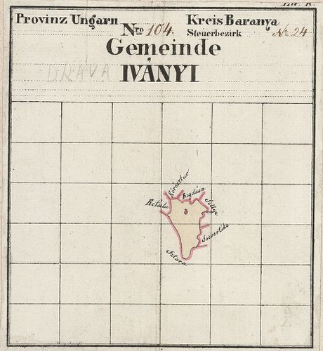
| Main title | Gemeinde Iványi in Ungarn ... |
| Subject | 014. téka - Drávaiványi - 1-3. Drávaiványi (Baranya m.) |
59. Königreich Ungarn nach Lipsky. [B IX a 500/2]
Institute and Museum of Military History •
B IX a
•
B IX Ausztria–Magyarország
•
B I–XV. Európa
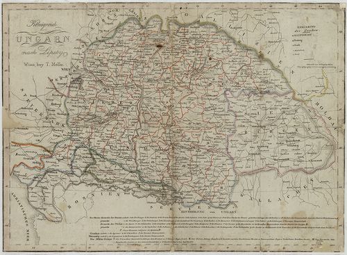
| Title | Königreich Ungarn nach Lipsky. |
| Main title | A Magyar Királyság térképe Lipszky térképe nyomán 1825 körül. |
60. Charte von Ungarn und Siebenbürgen. [B IX a 502/1]
Institute and Museum of Military History •
B IX a
•
B IX Ausztria–Magyarország
•
B I–XV. Európa
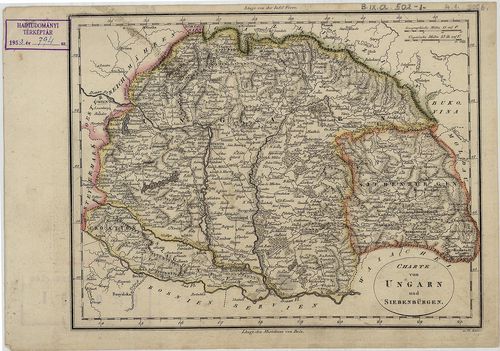
| Title | Charte von Ungarn und Siebenbürgen. |
| Main title | Magyarország és Erdély térképe a 19. század elején. |