1. Galíciai kormányzóság. [H IV d 599/11-8]
Institute and Museum of Military History •
1917. 11. hónap.
•
Orosz hadszíntér 1914. 08.-1918. 12. hó
•
H IV d (1914-1918)
•
H IV Újabbkori háborúk
•
H Háborúk
| Title | Galíciai kormányzóság. |
2. Galícia és Bukovina. [B IX a 420]
Institute and Museum of Military History •
B IX a
•
B IX Ausztria–Magyarország
•
B I–XV. Európa
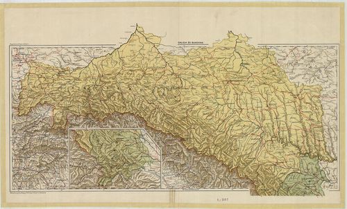
| Title | Galícia és Bukovina. |
3. Galícia és Bukovina. [B IX a 421]
Institute and Museum of Military History •
B IX a
•
B IX Ausztria–Magyarország
•
B I–XV. Európa
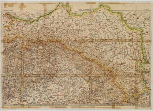
| Title | Galícia és Bukovina. |
4. [Lengyelország, Galícia tágabb környékének térképe.] [B XI c 85/1]
Institute and Museum of Military History •
B XI c
•
B XI Oroszország
•
B I–XV. Európa

| Title | [Lengyelország, Galícia tágabb környékének térképe.] |
5. Uibersichts Skelett des Königreiches Galizien und Lodomerien... [B IX a 377]
Institute and Museum of Military History •
B IX a
•
B IX Ausztria–Magyarország
•
B I–XV. Európa
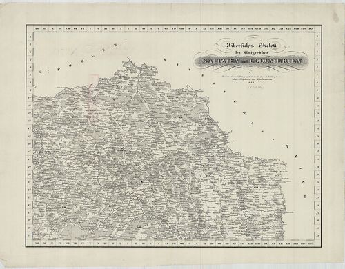
| Title | Uibersichts Skelett des Königreiches Galizien und Lodomerien. |
| Main title | Mt. Uibersicht der bestehenden Poststationen und Brief sammlungsorte. (Galícia és Volhínia áttekintő térképe a posta hivatalok, levélgyűjtőhelyek megnevezésével.) |
| Subject | Galícia és Volhínia áttekintő térképvázlata 1843-ban. Ker. jelölése. |
6. Körfénykép zárótűzszakaszról (Galicia, Nuszce.). Fedőterület... [H IV d 598/8-33/a]
Institute and Museum of Military History •
1916. 08. hónap.
•
Orosz hadszíntér 1914. 08.-1918. 12. hó
•
H IV d (1914-1918)
•
H IV Újabbkori háborúk
•
H Háborúk

| Title | Körfénykép zárótűzszakaszról (Galicia, Nuszce.). Fedőterület: 4014/4 |
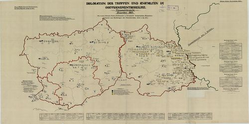
7. Az osztrák-magyar - német hadsereg általános helyzete Galíci... [H IV d 597/4-19]
Institute and Museum of Military History •
1915. 04. hónap.
•
Orosz hadszíntér 1914. 08.-1918. 12. hó
•
H IV d (1914-1918)
•
H IV Újabbkori háborúk
•
H Háborúk
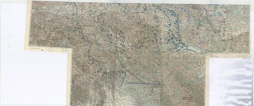
| Title | Az osztrák-magyar - német hadsereg általános helyzete Galíciában. |
8. [Galícia és Bukovina topográfiai térképe a 19. században.] [B IX a 425]
Institute and Museum of Military History •
B IX a
•
B IX Ausztria–Magyarország
•
B I–XV. Európa
| Title | [Galícia és Bukovina topográfiai térképe a 19. században.] |
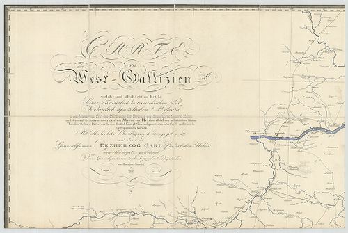
9. General-Carte von Westgallizien. [B XI a 108]
Institute and Museum of Military History •
B XI a
•
B XI Oroszország
•
B I–XV. Európa
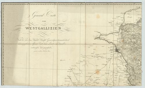
| Title | General-Carte von Westgallizien. |
| Main title | Nyugat-Galícia általános térképe. |
10. General Carte von Westgallizien. [B IX a 369]
Institute and Museum of Military History •
B IX a
•
B IX Ausztria–Magyarország
•
B I–XV. Európa
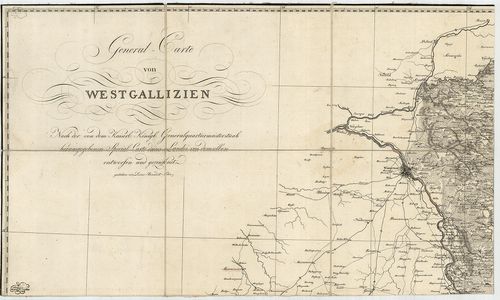
| Title | General Carte von Westgallizien. |
| Main title | Nyugat-Galícia általános térképe. |
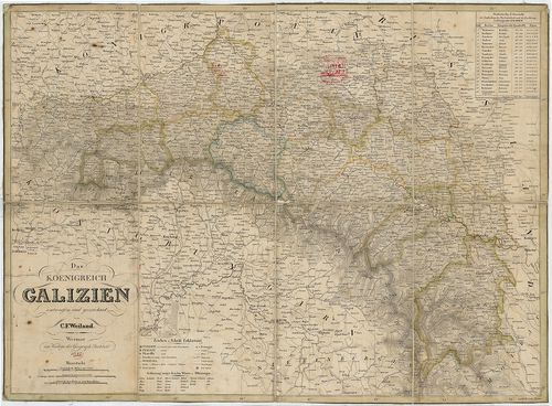
11. Karte des Königreiches Galizien. [B IX a 1160]
Institute and Museum of Military History •
B IX a
•
B IX Ausztria–Magyarország
•
B I–XV. Európa
| Title | Karte des Königreiches Galizien. |
| Main title | A Galíciai Királyság térképe. |
12. Karte von West-Gallizien. [B XI a 107]
Institute and Museum of Military History •
B XI a
•
B XI Oroszország
•
B I–XV. Európa
| Title | Karte von West-Gallizien. |
| Main title | Nyugat-Galícia térképe 1808-ban. |
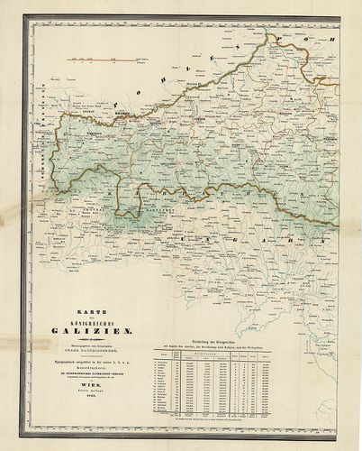
13. Das Koenigreich Galizien. [B IX a 376]
Institute and Museum of Military History •
B IX a
•
B IX Ausztria–Magyarország
•
B I–XV. Európa
| Title | Das Koenigreich Galizien. |
| Main title | A Galíciai Királyság térképe 1842-ben. |
14. Strassen-Karte des Koenigreiches Galizien und Lodomerien. [B IX c 496]
Institute and Museum of Military History •
B IX c
•
B IX Ausztria–Magyarország
•
B I–XV. Európa
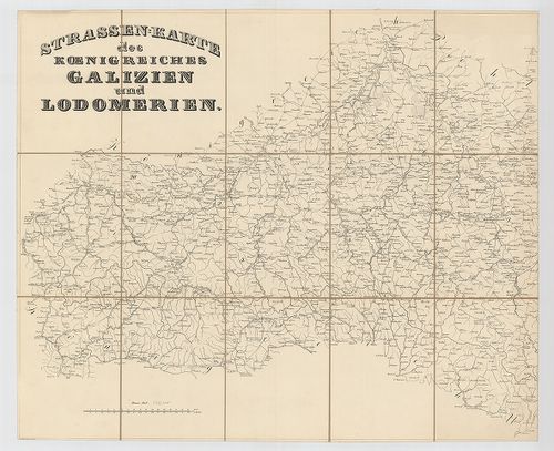
| Title | Strassen-Karte des Koenigreiches Galizien und Lodomerien. |
| Main title | Galícia és Lodoméria úttérképe. |
15. Lubomeriae et Galliciae Regni Tabula Geographica. [B IX a 378]
Institute and Museum of Military History •
B IX a
•
B IX Ausztria–Magyarország
•
B I–XV. Európa
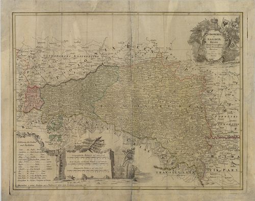
| Title | Lubomeriae et Galliciae Regni Tabula Geographica. |
| Main title | Galícia és Volhínia térképe 1775-ben. |
16. West-Russland u.[nd] Galizien. Orographie. [B XI b 33/1]
Institute and Museum of Military History •
B XI b
•
B XI Oroszország
•
B I–XV. Európa
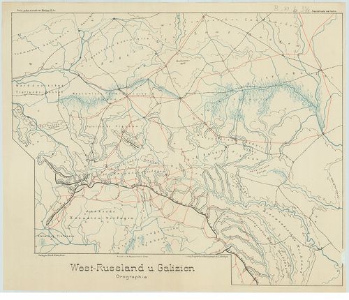
| Title | West-Russland u.[nd] Galizien. Orographie. |
| Main title | Nyugat-Oroszország és Galícia hegyvízrajzi térképe. |
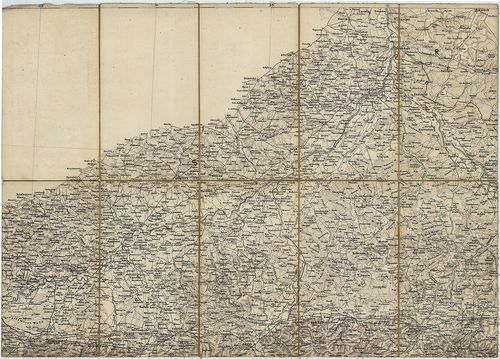
17. Mapa Komunikacyjna Galicyi i Bukowiny. [B IX a 400]
Institute and Museum of Military History •
B IX a
•
B IX Ausztria–Magyarország
•
B I–XV. Európa
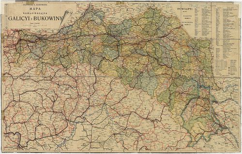
| Title | Mapa Komunikacyjna Galicyi i Bukowiny. |
| Main title | Galícia és Bukovina közlekedési térképe 1911 körül. |
18. West-Russland u[nd] Galizien. Hydrographie. [B XI b 33/2]
Institute and Museum of Military History •
B XI b
•
B XI Oroszország
•
B I–XV. Európa
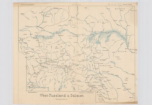
| Title | West-Russland u[nd] Galizien. Hydrographie. |
| Main title | Nyugat-Oroszország és Galícia hegyvízrajzi térképe. |
19. Operationen aus Nordost-Galizien nach Wolhgnien. [B XI c 340]
Institute and Museum of Military History •
B XI c
•
B XI Oroszország
•
B I–XV. Európa
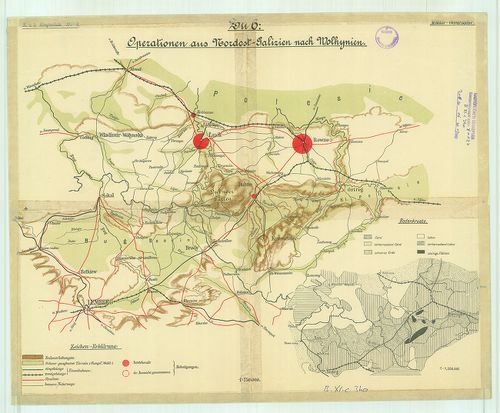
| Title | Operationen aus Nordost-Galizien nach Wolhgnien. |
| Main title | ÉK-Galicia és Volkinia katonaföldrajzi vázlata |
20. Übersichtskarte der Communicationen im Kárpatengebiete. [B IX c 1059]
Institute and Museum of Military History •
B IX c
•
B IX Ausztria–Magyarország
•
B I–XV. Európa
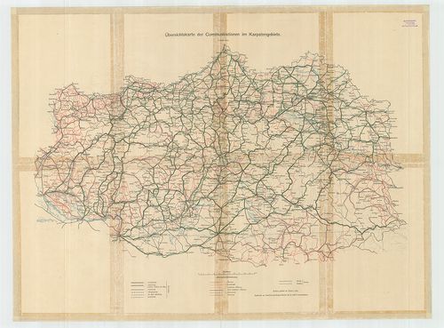
| Title | Übersichtskarte der Communicationen im Kárpatengebiete. |
| Main title | Észak-Magyarország és Galícia közlekedési térképe 1898 körül. |