221. A Duna hajózási vázlata Dévénytől a Tisza torkolatáig. [B XV b 230]
Institute and Museum of Military History •
B XV b
•
B XV Magyarország (1920 után)
•
B I–XV. Európa
| Title | A Duna hajózási vázlata Dévénytől a Tisza torkolatáig. |
| Main title | Távolságmutató a Morva-torkolat–Budapest közötti folyamszakaszhoz, távolságmutató a Budapest–Tisza-torkolat közötti folyamszakaszhoz. |
222. Carte Ethnographique des pays Danubiens. [B II c 213]
Institute and Museum of Military History •
B II c
•
B II Európa, nagyobb részek és országcsoportok
•
B I–XV. Európa
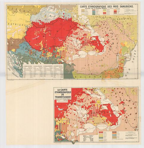
| Title | Carte Ethnographique des pays Danubiens. |
| Main title | Mt. La Carte Ethnographique de Transylvanie. (Erdély néprajzi térképe. |
| Subject | A Duna-medence néprajzi térképe 1928 körül. |
223. Totius Regni Hungariae Maximaeque Partis Danubii Fluminis un... [B IX a 1137]
Institute and Museum of Military History •
B IX a
•
B IX Ausztria–Magyarország
•
B I–XV. Európa
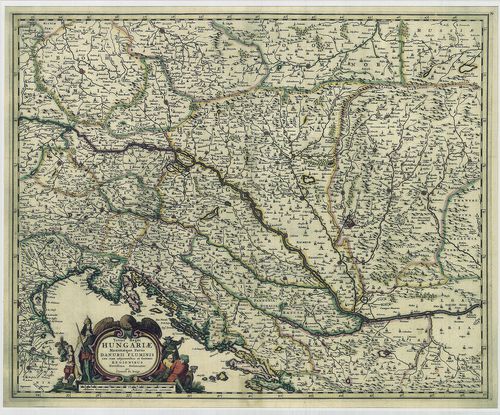
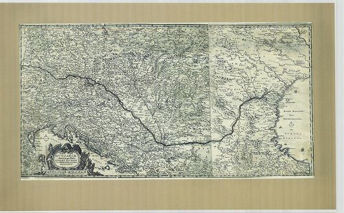
| Title | Totius Regni Hungariae Maximaeque Partis Danubii Fluminis una cum adjacentibus et finitimis Regionibus. |
| Main title | A Magyar Királyság térképe a környező Duna menti részekkel. |
224. Plan der Donau Strecke von Semlin bis zu der Passage Eiserne... [B IX b 403]
Institute and Museum of Military History •
B IX b
•
B IX Ausztria–Magyarország
•
B I–XV. Európa
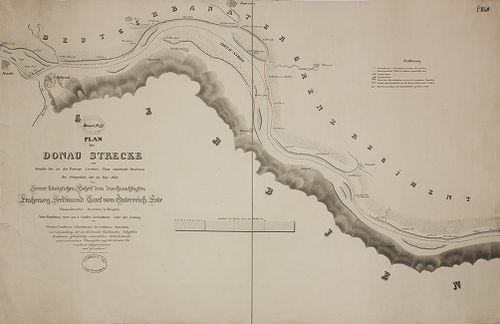
| Title | Plan der Donau Strecke von Semlin bis zu der Passage Eisernes Thor unterhalb Orschowa... |
| Main title | A Duna Zemlintől Orsováig a Vaskapu-szoroson át. |
225. Rapports Plan „B” von dem Blockhause in dem Hauptfort des Wa... [G I h 185/184]
Institute and Museum of Military History •
G I h vár alaprajzok, város és környéktérképek, utikönyvek
•
G I Európa
•
G I–V. Úti térképek
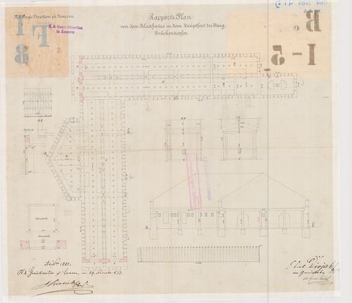
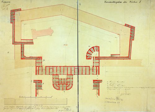
| Title | Rapports Plan „B” von dem Blockhause in dem Hauptfort des Waag-Brückenkopfes. |
| Main title | Komárom, a Vág–Dunai hídfő főőrség blokkházának tervrajza 1877-ből. |
226. Atelköz, oder das Land zwischen dem Fluss Wohnsitz der Unger... [B III a 8]
Institute and Museum of Military History •
B III a
•
B III Balkán-félsziget
•
B I–XV. Európa
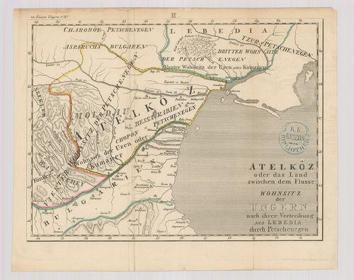
| Title | Atelköz, oder das Land zwischen dem Fluss Wohnsitz der Ungern nach ihrer Vertreibung aus Lebedia durch Petschenegen. |
| Main title | A Duna-delta vidékének térképe. |
227. Die Donaustrecke von Báziás bis Turnu-Severinu mit der Strom... [B III b 33]
Institute and Museum of Military History •
B III b
•
B III Balkán-félsziget
•
B I–XV. Európa
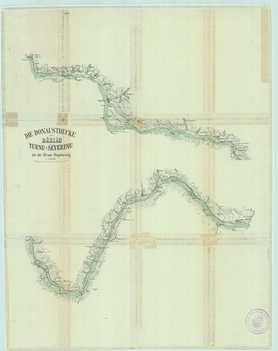
| Title | Die Donaustrecke von Báziás bis Turnu-Severinu mit der Strom-Regulierung. |
| Main title | Az Al-Duna szabályozási-terv térképe Báziástól–Turnu-Severinig 1900 körül. |
228. [Mappa Mercantilis] - Mappa Geographica facta in usum Commer... [B IX c 1408]
Institute and Museum of Military History •
B IX c
•
B IX Ausztria–Magyarország
•
B I–XV. Európa
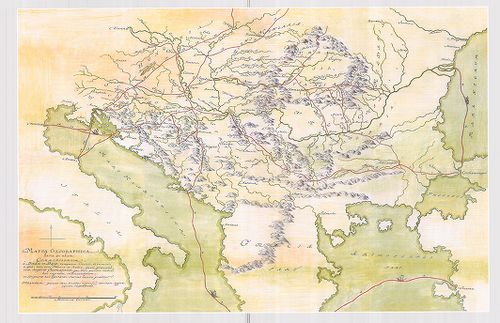
| Title | [Mappa Mercantilis] - Mappa Geographica facta in usum Commerciorum. |
| Main title | Földrajzi térkép, amely kereskedők használatára készült.[Kereskedelmi térkép]. |
Technical features: [...] cm Kéziratos térkép faximile kiadása Duna Múzeum Esztergom É i tájolás [...]
229. Mapa de la Transilvania, Valachia, Servia, e [Bul]garia con ... [H III c 100]
Institute and Museum of Military History •
H III c (1651–1700)
•
H III Újkori háborúk (1492–1789)
•
H Háborúk
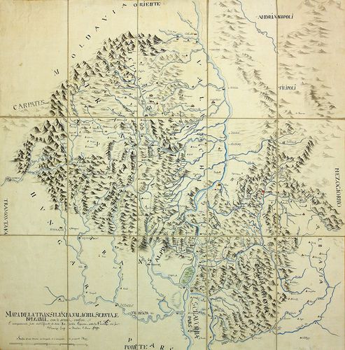
| Title | Mapa de la Transilvania, Valachia, Servia, e [Bul]garia con li svuoi confini … l’Anno 1690. |
| Main title | Duna–Tisza összefolyása és környéke 1690-ben. |
230. Totius Regni Hungariae Maximae que Partis Danubii Fluminis ... [B IX a 1138]
Institute and Museum of Military History •
B IX a
•
B IX Ausztria–Magyarország
•
B I–XV. Európa
| Title | Totius Regni Hungariae Maximae que Partis Danubii Fluminis una cum adjacentibus et finitimis Regionibus. |
| Main title | A Magyar Királyság térképe a környező Duna menti részekkel. |
231. Plan vortheilhaften Truppen-Aufstellungen zwischen der Dunau... [B IX a 1117]
Institute and Museum of Military History •
B IX a
•
B IX Ausztria–Magyarország
•
B I–XV. Európa

| Title | Plan vortheilhaften Truppen-Aufstellungen zwischen der Dunau, der Raab und dem Blatten See. |
| Main title | A csapatok mozgása a Duna, Rába és a Balaton között. |
232. Karte von Central Europa zur Übersicht der Eisenbahnen einsc... [B II c 6]
Institute and Museum of Military History •
B II c
•
B II Európa, nagyobb részek és országcsoportok
•
B I–XV. Európa
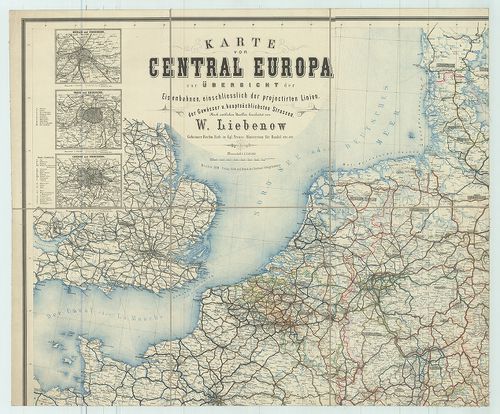
| Title | Karte von Central Europa zur Übersicht der Eisenbahnen einschliesslich der projectirten Linien, der Gewässer u. hauptsächlichsten Strassen. |
| Main title | 6 mt.: 1. Berlin u. Umgegend. |
| Subject | (Berlin és környéke). 2. Paris u. Umgegend. |
Content: Dunai fejedelemségek
233. Die Donau vom Ursprung bis Ulm. Der schiffbare Donau-Strom v... [B IX b 116]
Institute and Museum of Military History •
B IX b
•
B IX Ausztria–Magyarország
•
B I–XV. Európa

| Title | Die Donau vom Ursprung bis Ulm. Der schiffbare Donau-Strom von Ulm bis Pressburg. |
| Main title | A Duna eredetétől Ulmig, valamint a hajózható szakasz Ulmtól Pozsonyig. |
234. Rapports-Plan über das Fridens-Pulvermagazin vor dem Waag-Br... [G I h 185/124]
Institute and Museum of Military History •
G I h vár alaprajzok, város és környéktérképek, utikönyvek
•
G I Európa
•
G I–V. Úti térképek
| Title | Rapports-Plan über das Fridens-Pulvermagazin vor dem Waag-Brückenkof auf 2000. |
| Main title | Komárom. Vág–Dunai hídfő mellett lévő béke lőporraktár, (hadianyagraktár) tervrajza 1864-ből. |
235. Entwurf einer permanenten Befestigung der Palatinai-Linie v.... [G I h 185/253]
Institute and Museum of Military History •
G I h vár alaprajzok, város és környéktérképek, utikönyvek
•
G I Európa
•
G I–V. Úti térképek
| Title | Entwurf einer permanenten Befestigung der Palatinai-Linie v. J. 1834. und zwei Detailplan und Kasematten-Plan. |
| Main title | A dunai hídfők erődjében helyreállított megerősített laktanya keresztmetszete. |
236. Mapa vodnich drah ve Středni Evrope. – Plavebno spojeni Duna... [B II b 33]
Institute and Museum of Military History •
B II b
•
B II Európa, nagyobb részek és országcsoportok
•
B I–XV. Európa
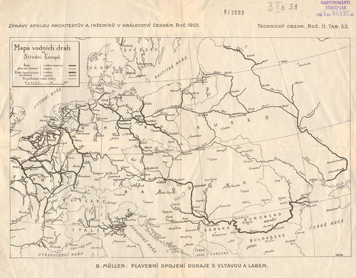
| Title | Mapa vodnich drah ve Středni Evrope. – Plavebno spojeni Dunaje s Vltavou a Labem. (Duna–Moldva–Elba hajózási csatlakozása.) |
| Main title | Közép-Európa vízrajzi térképe 1903-ban. |
237. Abrechnungsplan lit: B über die Anlage von Senkgruben-Ventil... [G I h 185/33]
Institute and Museum of Military History •
G I h vár alaprajzok, város és környéktérképek, utikönyvek
•
G I Európa
•
G I–V. Úti térképek
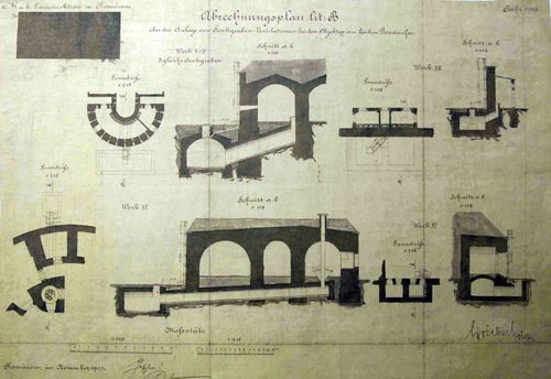
| Title | Abrechnungsplan lit: B über die Anlage von Senkgruben-Ventilationen bei den Objekten am linken Donanufer. |
| Main title | Komárom: Az erődítés emésztőgödrének mesterséges szellőzőberendezése a Duna balpartján. |
238. Belagerung von Ismail 1790. [H IV a 9]
Institute and Museum of Military History •
H IV a (1700–1820)
•
H IV Újabbkori háborúk
•
H Háborúk
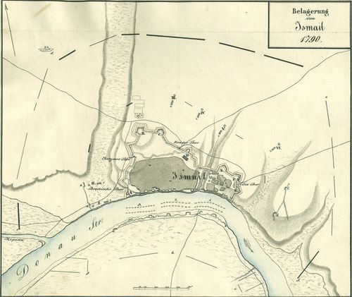
| Title | Belagerung von Ismail 1790. |
| Main title | A török Ismail ostromának helyszínrajza 1790. Város és erődei alaprajzban. Orosz hadállások a szárazföldön és a Dunán. Sáncok, felvonulási utak. |
239. Skizze der Redonte XII. des Donaubrückenkopf zum Eleborat üb... [G I h 185/110]
Institute and Museum of Military History •
G I h vár alaprajzok, város és környéktérképek, utikönyvek
•
G I Európa
•
G I–V. Úti térképek
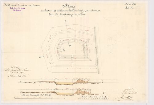
| Title | Skizze der Redonte XII. des Donaubrückenkopf zum Eleborat über die Einebunngderselben. „A” |
| Main title | Komárom. A DUNAI hídfő XII. erődjének az alaprajza és keresztmetszete 1875-ből. |
240. Skizze der Redonte X. des Donaubrückenkopf zum Eleborat über... [G I h 185/109]
Institute and Museum of Military History •
G I h vár alaprajzok, város és környéktérképek, utikönyvek
•
G I Európa
•
G I–V. Úti térképek
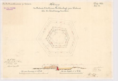
| Title | Skizze der Redonte X. des Donaubrückenkopf zum Eleborat über die Einebunngderselben. „C” |
| Main title | Komárom. A DUNAI hídfő X. erődjének az alaprajza és keresztmetszete 1875-ből. |