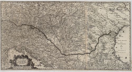
221. Delineation des kaiserlichen Feldlagers … bei Prespurg … d. ... [H III d 859]
Institute and Museum of Military History •
H III d (1700–1740)
•
H III Újkori háborúk (1492–1789)
•
H Háborúk
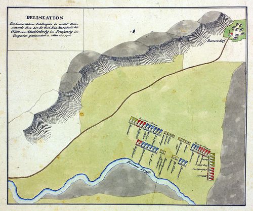
| Title | Delineation des kaiserlichen Feldlagers … bei Prespurg … d. Mai 1707. |
| Main title | A császári hadsereg táborhelye Pozsonynál, Récse (Ratzersdorf, Raca) és a Duna között 1707. (Rákóczi-szabadságharc.) Hadrend, vázlatos környékrajz. |
222. Acampamento de francesi e degli imperiali sulle sponde del D... [H III d 101]
Institute and Museum of Military History •
H III d (1700–1740)
•
H III Újkori háborúk (1492–1789)
•
H Háborúk
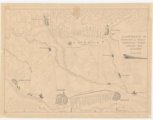
| Title | Acampamento de francesi e degli imperiali sulle sponde del Danubio Anno 1703. |
| Main title | Francia–német háború 1703. Hadállások a Duna Gundelfingen–Launingen–Dillingeni térségében a megerősített helyek feltüntetésével. |
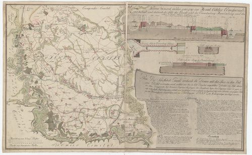
223. Théâtre des Opérations Entre le Danube et l’Isar en Avril 18... [B IV b 23]
Institute and Museum of Military History •
B IV b
•
B IV Német birodalom
•
B I–XV. Európa
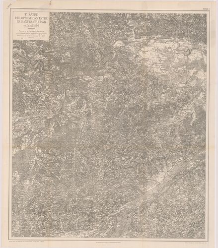
| Title | Théâtre des Opérations Entre le Danube et l’Isar en Avril 1809. |
| Main title | A Duna és Isar közötti terület katonai térképe a francia–bajor háború alatt 1807-ben. |
224. Balaton. [B XV c 857]
Institute and Museum of Military History •
B XV c
•
B XV Magyarország (1920 után)
•
B I–XV. Európa
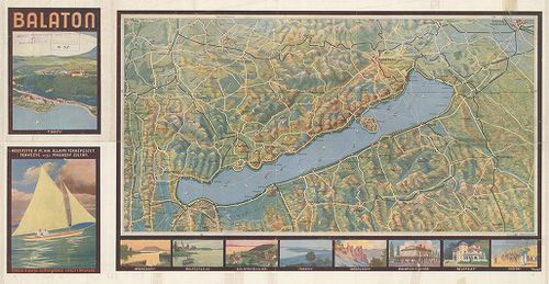
| Title | Balaton. |
Technical features: Budapest 1930 A Duna Száva Adria Vasúttársaság Ny M [...]
225. L’accampamento del di 29 di agosto. [1687.] [H III c 182/34]
Institute and Museum of Military History •
H III c (1651–1700)
•
H III Újkori háborúk (1492–1789)
•
H Háborúk
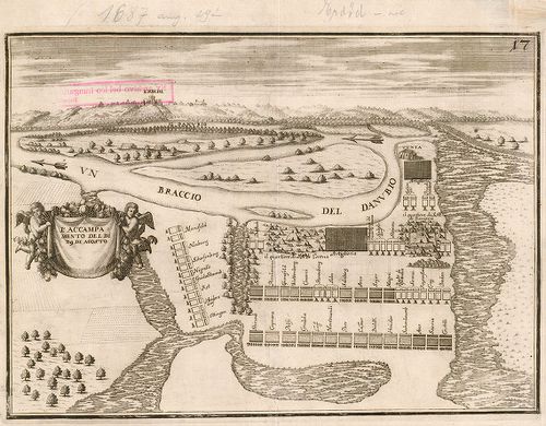
| Title | L’accampamento del di 29 di agosto. [1687.] |
| Main title | Az egyesült török elleni hadak táborhelye Erdőddel (Erdut) szemben a Duna bal partján 1687. augusztus 29-én. A környék madártávlatban. |
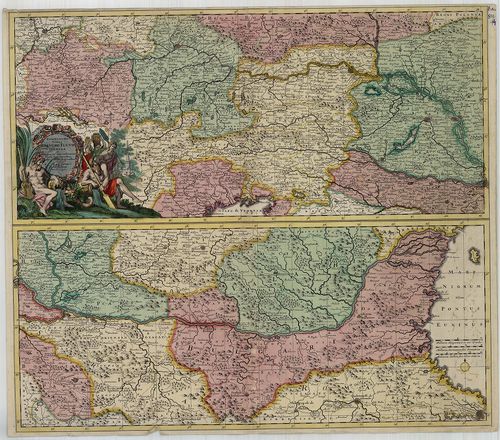
226. Archiducatus Austriae Inferioris accuratissima Geographica D... [B IX a 241/1]
Institute and Museum of Military History •
B IX a
•
B IX Ausztria–Magyarország
•
B I–XV. Európa
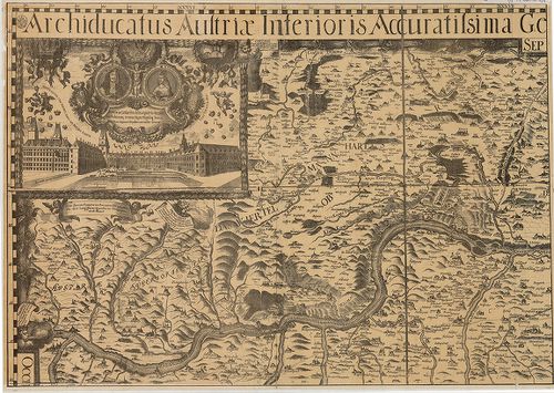
| Title | Archiducatus Austriae Inferioris accuratissima Geographica Descriptio… |
| Main title | Sarokrajzok: I. Lipót császár és Margarita császárné arcképe, az Osztrák kancellária, a Duna látképe, térképezés stb. |
| Subject | Alsó-Ausztria térképe 1670-ben. |
227. Plan über die jenseitige Bannatischen Districten … 1737. [H III d 1299]
Institute and Museum of Military History •
H III d (1700–1740)
•
H III Újkori háborúk (1492–1789)
•
H Háborúk
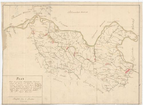
| Title | Plan über die jenseitige Bannatischen Districten … 1737. |
| Main title | A Bánságon túli területek az 1737. évi hadműveletek idején. A Duna vonalától délre Kubin és Radoievaz (Radujevac) közötti terület. Hadállások, menetvonalak. |
228. Plan des Donau-Strommes Von Wien bis Orshova-[Rostzig] zusam... [B IX b 128/1]
Institute and Museum of Military History •
B IX b
•
B IX Ausztria–Magyarország
•
B I–XV. Európa
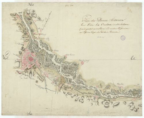
| Title | Plan des Donau-Strommes Von Wien bis Orshova-[Rostzig] zusammengesetzt aus verschiedenen und mehreren Wasserreisen vom Officiers-Corps des Pontoniers-Bataillons. |
| Main title | A Duna folyam Bécs-Orsova-Rusze között. |
229. Veldt Lager zwischen Mohaz und Baranuivar den 15. July 1691. [H III c 182/37]
Institute and Museum of Military History •
H III c (1651–1700)
•
H III Újkori háborúk (1492–1789)
•
H Háborúk
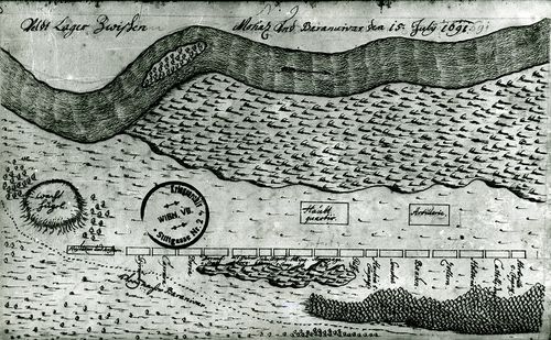
| Title | Veldt Lager zwischen Mohaz und Baranuivar den 15. July 1691. |
| Main title | A török elleni hadak táborhelye Mohács és Baranyavár (Branjin Vrh.) között 1691. július 15-én a Duna mellett. |
230. L’accampamento delle genti del ser[enissi]mo Elettore pianta... [H III c 182/8]
Institute and Museum of Military History •
H III c (1651–1700)
•
H III Újkori háborúk (1492–1789)
•
H Háborúk
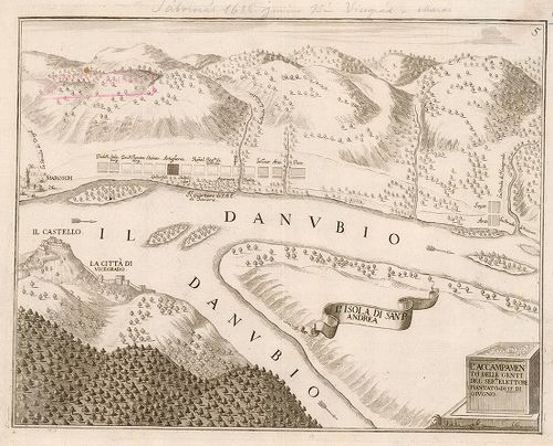
| Title | L’accampamento delle genti del ser[enissi]mo Elettore piantato a di 15 di giugno. [1686.] |
| Main title | A bajor választófejedelem csapatainak táborhelye Nagymaros alatt, Visegráddal szemben a Duna bal partján. |
231. Plan des Schiffahrts, Canals wodurch die Donau mit der Theis... [B IX b 145/1]
Institute and Museum of Military History •
B IX b
•
B IX Ausztria–Magyarország
•
B I–XV. Európa
| Title | Plan des Schiffahrts, Canals wodurch die Donau mit der Theis in dem Batcser… |
| Main title | A Duna–Tisza közti hajózható csatorna (Ferenc-csatorna, Bácskai- nagy-csatorna) térképe 1816-ban, Bajától-Titelig. |
232. A Duna folyam Ó-Moldova (Moldova-Veche) – Turn[u]-Szeverini ... [B IX b 125/3]
Institute and Museum of Military History •
B IX b
•
B IX Ausztria–Magyarország
•
B I–XV. Európa

| Title | A Duna folyam Ó-Moldova (Moldova-Veche) – Turn[u]-Szeverini (Turnu Severin) zuhatagos szakaszának átnézeti térképe. – Map of the cataracts of the lower Danube between Moldova and Turn[u]-Severin. |
233. Neue durch den lezten Krieg der drei Kaiserhőfe verbesserte ... [B IX a 1022]
Institute and Museum of Military History •
B IX a
•
B IX Ausztria–Magyarország
•
B I–XV. Európa
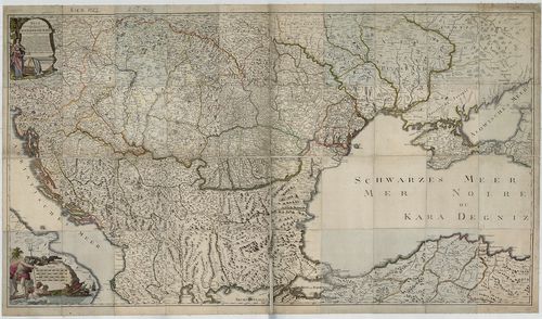
| Title | Neue durch den lezten Krieg der drei Kaiserhőfe verbesserte Geographische Karte samt den neuen bestimten Poststazionen… |
| Main title | A Duna menti országok térképe 1792-ben a postaállomások jelölésével. (Kremstől a Fekete-tengerig.) |
234. Totius Regni Hungariae Maxim ae que Partis Danubii Fluminis ... [B IX a 539/10]
Institute and Museum of Military History •
B IX a
•
B IX Ausztria–Magyarország
•
B I–XV. Európa
| Title | Totius Regni Hungariae Maxim ae que Partis Danubii Fluminis una cum adjacentibus et finitimis Regionibus. |
| Main title | A Magyar Királyság és a Duna országainak általános térképe a 17. században, de Jonghe nyomán. |
235. Exactissima Totius Danubii Fluvii Tabula et minores in eum i... [B IX a 539/14]
Institute and Museum of Military History •
B IX a
•
B IX Ausztria–Magyarország
•
B I–XV. Európa
| Title | Exactissima Totius Danubii Fluvii Tabula et minores in eum influentes Fluvii, cum Omnibus adjacentibus Regionibus. |
| Main title | A Duna menti országok térképe 2 részletben a 17. század végén. (Württembergtől – a Fekete-tengerig.) |
236. Westrussland bis zum Dniepr die Ostseeprovinzen und die Nied... [B II a 46]
Institute and Museum of Military History •
B II a
•
B II Európa, nagyobb részek és országcsoportok
•
B I–XV. Európa
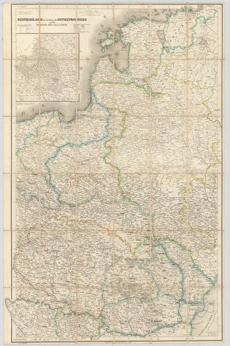
| Title | Westrussland bis zum Dniepr die Ostseeprovinzen und die Nieder-Donauländer. |
| Main title | Mt.: [Kelet-Europa.] |
| Subject | Oroszország NY-i része a Dnyeperig, a Keleti-tenger országai és a Duna országainak térképe 1853-ban. |
237. L’accampamento degli eserciti piantato a di 18 di settembre ... [H III c 182/19]
Institute and Museum of Military History •
H III c (1651–1700)
•
H III Újkori háborúk (1492–1789)
•
H Háborúk

| Title | L’accampamento degli eserciti piantato a di 18 di settembre dell’a 1686. |
| Main title | Az egyesült török elleni hadak táborhelye a Duna jobb partján Gerge-Vetlar (Gerjen) alatt 1686. szeptember 18-án. |
238. L’accampamento posto a di 1 e levato a di 4 di settembre. [1... [H III c 182/35]
Institute and Museum of Military History •
H III c (1651–1700)
•
H III Újkori háborúk (1492–1789)
•
H Háborúk
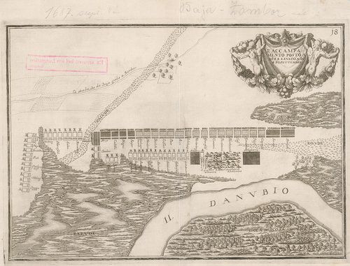
| Title | L’accampamento posto a di 1 e levato a di 4 di settembre. [1687.] |
| Main title | Az egyesült török elleni hadak táborhelye a Duna bal partján, a baja–zombori út mellett 1687-ben. |
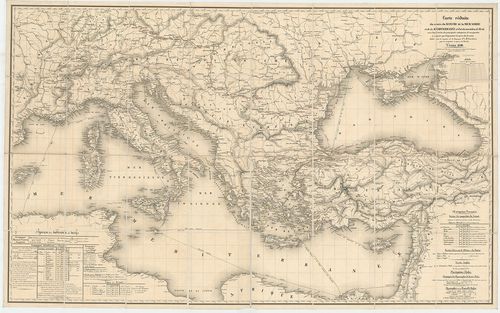
239. Carte réduite du cours du Danube de la Mer Noire et de la Me... [B IX b 137]
Institute and Museum of Military History •
B IX b
•
B IX Ausztria–Magyarország
•
B I–XV. Európa
| Title | Carte réduite du cours du Danube de la Mer Noire et de la Mediterranée… |
| Main title | A Duna folyó, a Fekete-tenger és a Földközi-tenger térképe a legfontosabb gőzhajóútvonalak feltüntetésével 1840-ben. |
240. Questo campo fu piantato a di 15. e levato a di 16 di settem... [H III c 182/18]
Institute and Museum of Military History •
H III c (1651–1700)
•
H III Újkori háborúk (1492–1789)
•
H Háborúk
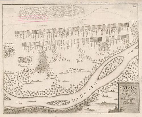
| Title | Questo campo fu piantato a di 15. e levato a di 16 di settembre [1686.] |
| Main title | Az egyesült török elleni hadak táborhelye a Duna jobb partján Madocsától északra, 1668. szeptember 16-án. |