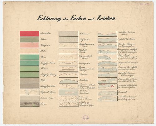
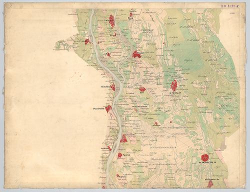
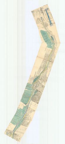
1041. A Duna és mellékfolyóinak ártere Alsó-Magyarországban. – Ter... [B IX b 110]
Institute and Museum of Military History •
B IX b
•
B IX Ausztria–Magyarország
•
B I–XV. Európa
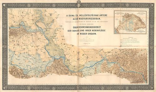
| Title | A Duna és mellékfolyóinak ártere Alsó-Magyarországban. – Terrain d’inondation du Danube et de ses affluents en basse Hongrie. – Ueber-schwemmungsgebiet der Donau und ihrer nebenflüsse in Nieder-Ungarn. |
| Main title | Mt. A magyarországi Duna és mellékfolyói árterének átnézeti térképe. – Terrain d’inondation du Danube et de ses affluents en Hongrie. – Überschwemmungsgebiet der Donau und deren nebenflüsse in Ungarn. |
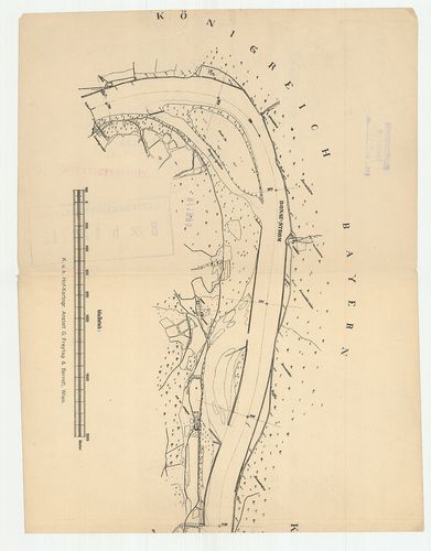
1042. [A Duna Bécs és Giorgio közti szakaszának térképe.] [B IX b 112]
Institute and Museum of Military History •
B IX b
•
B IX Ausztria–Magyarország
•
B I–XV. Európa
| Title | [A Duna Bécs és Giorgio közti szakaszának térképe.] |
1043. Plan von dem Laufe des Donau Stroms von Ofen bis Baja. [B IX b 115]
Institute and Museum of Military History •
B IX b
•
B IX Ausztria–Magyarország
•
B I–XV. Európa
| Title | Plan von dem Laufe des Donau Stroms von Ofen bis Baja. |
| Main title | A Duna Buda és Baja között 1740 körül. |
1044. A’ Ferencz csatorna Pestig hosszabbításának eszméje. [B IX b 115/2]
Institute and Museum of Military History •
B IX b
•
B IX Ausztria–Magyarország
•
B I–XV. Európa

| Title | A’ Ferencz csatorna Pestig hosszabbításának eszméje. |
1045. Die Donau vom Ursprung bis Ulm. Der schiffbare Donau-Strom v... [B IX b 116]
Institute and Museum of Military History •
B IX b
•
B IX Ausztria–Magyarország
•
B I–XV. Európa

| Title | Die Donau vom Ursprung bis Ulm. Der schiffbare Donau-Strom von Ulm bis Pressburg. |
| Main title | A Duna eredetétől Ulmig, valamint a hajózható szakasz Ulmtól Pozsonyig. |
1046. Karte der Donau von ihrem Ursprunge bis an die Mündung. [B IX b 117]
Institute and Museum of Military History •
B IX b
•
B IX Ausztria–Magyarország
•
B I–XV. Európa
| Title | Karte der Donau von ihrem Ursprunge bis an die Mündung. |
| Main title | A Duna térképe eredetétől a torkolatig 1850 körül. |
1047. Carte du cours du Danube depuis Ulm jusqua son embouchure da... [B IX b 118]
Institute and Museum of Military History •
B IX b
•
B IX Ausztria–Magyarország
•
B I–XV. Európa
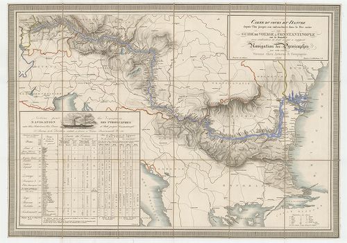
| Title | Carte du cours du Danube depuis Ulm jusqua son embouchure dans la Mer noire ou guide de voyage a Constantinople… |
| Main title | A Duna Ulmtól a Fekete-tengerig 1839 körül a folyómenti települések feltüntetésével. |
1048. A Duna Orsova-Szulina-i szakasza. [B IX b 119]
Institute and Museum of Military History •
B IX b
•
B IX Ausztria–Magyarország
•
B I–XV. Európa
| Title | A Duna Orsova-Szulina-i szakasza. |
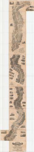
1049. Panorama der Donau von Linz bis Wien. [B IX b 120]
Institute and Museum of Military History •
B IX b
•
B IX Ausztria–Magyarország
•
B I–XV. Európa
| Title | Panorama der Donau von Linz bis Wien. |
| Main title | A Duna madártávlati képe Linz és Bécs között 1839-ben. |
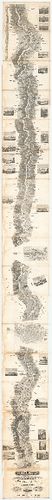
1050. Panorama der Donau von Regensburg bis Linz in Vogelperspecti... [B IX b 121]
Institute and Museum of Military History •
B IX b
•
B IX Ausztria–Magyarország
•
B I–XV. Európa
| Title | Panorama der Donau von Regensburg bis Linz in Vogelperspective. |
| Main title | A Duna madártávlati képe Regensburg és Linz között 1840-ben. |
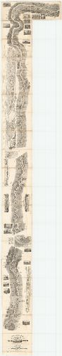
1051. Panorama der Donau von Wien bis Pesth. [B IX b 122]
Institute and Museum of Military History •
B IX b
•
B IX Ausztria–Magyarország
•
B I–XV. Európa
| Title | Panorama der Donau von Wien bis Pesth. |
| Main title | A Duna madártávlati képe Bécs és Pest között 1842-ben. |
1052. A Duna Ulmtól a torkolatig. – Die Donau von Ulm bis zur Münd... [B IX b 122/1]
Institute and Museum of Military History •
B IX b
•
B IX Ausztria–Magyarország
•
B I–XV. Európa
| Title | A Duna Ulmtól a torkolatig. – Die Donau von Ulm bis zur Mündung átnézeti térképe |
1053. Topographisch hydrometrischen Donau Strom Karte von Petronel... [B IX b 122/2]
Institute and Museum of Military History •
B IX b
•
B IX Ausztria–Magyarország
•
B I–XV. Európa
| Title | Topographisch hydrometrischen Donau Strom Karte von Petronell… |
| Main title | A Duna topográfiai térképe Petronelltől (Alsó-Ausztria) Csernetzig (Vaskapu-szoros). |
1054. [Topographisch hydrometrischen Donau Strom Karte von Petrone... [B IX b 122/3]
Institute and Museum of Military History •
B IX b
•
B IX Ausztria–Magyarország
•
B I–XV. Európa
| Title | [Topographisch hydrometrischen Donau Strom Karte von Petronell… |
| Main title | A Duna topográfiai térképe 1890 körül. |
1055. Die Donau von ihrem Ursprung bis an die Mündung. Eine Schild... [B IX b 122/8]
Institute and Museum of Military History •
B IX b
•
B IX Ausztria–Magyarország
•
B I–XV. Európa
| Title | Die Donau von ihrem Ursprung bis an die Mündung. Eine Schilderung von Land und Leuten des Donaugebietes. |
| Main title | A Duna eredetétől a torkolatig, valamint a Duna menti népek és vidékek leírása 1881-ben. |
1056. Karte der Donau von ihrem Ursprunge bis an die Mündung. [B IX b 122/10]
Institute and Museum of Military History •
B IX b
•
B IX Ausztria–Magyarország
•
B I–XV. Európa
| Title | Karte der Donau von ihrem Ursprunge bis an die Mündung. |
| Main title | A Duna térképe eredetétől a torkolatig 1900 körül. |
1057. Duna helyszínrajz Schlägen-Linz és Linz-Ybbs között. [B IX b 122/11]
Institute and Museum of Military History •
B IX b
•
B IX Ausztria–Magyarország
•
B I–XV. Európa
| Title | Duna helyszínrajz Schlägen-Linz és Linz-Ybbs között. |
1058. [A Duna térképe Lindentől-Kaltenbachig.] [B IX b 122/12]
Institute and Museum of Military History •
B IX b
•
B IX Ausztria–Magyarország
•
B I–XV. Európa
| Title | [A Duna térképe Lindentől-Kaltenbachig.] |
1059. Preliminaire Donau Karte. [B IX b 123]
Institute and Museum of Military History •
B IX b
•
B IX Ausztria–Magyarország
•
B I–XV. Európa
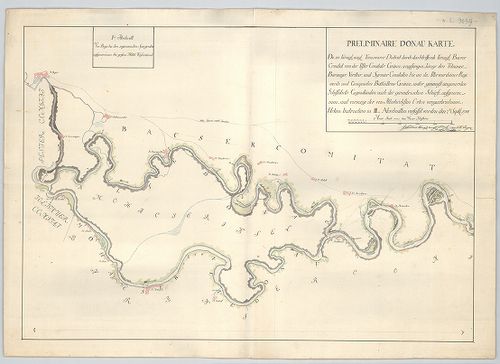
| Title | Preliminaire Donau Karte. |
| Main title | A Duna térképe Bajától Péterváradig 1788 szeptemberben. |
1060. A Soroksári Dunaág helyszínrajza a Tassi zsiliptől a Gubacsi... [B IX b 124]
Institute and Museum of Military History •
B IX b
•
B IX Ausztria–Magyarország
•
B I–XV. Európa
| Title | A Soroksári Dunaág helyszínrajza a Tassi zsiliptől a Gubacsi hídig. |