981. [Határtérképek Magyarország és Lengyelország között.] [B IX c 1493]
Institute and Museum of Military History •
B IX c
•
B IX Ausztria–Magyarország
•
B I–XV. Európa
| Title | [Határtérképek Magyarország és Lengyelország között.] |
982. Magyarország hegy- és vízrajzi térképe az esővonalakkal. – O... [B IX b 23/6]
Institute and Museum of Military History •
B IX b
•
B IX Ausztria–Magyarország
•
B I–XV. Európa
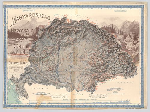
| Title | Magyarország hegy- és vízrajzi térképe az esővonalakkal. – Orographical and hydrographical map of Hungary showing the distribution of rains. |
| Main title | 1900–1910 évek átlaga alapján készült csapadéktérkép, a piros izovonalakat 1912 körül nyomták rá. |
983. Magyarország geológiai térképe. [B IX b 23/7]
Institute and Museum of Military History •
B IX b
•
B IX Ausztria–Magyarország
•
B I–XV. Európa
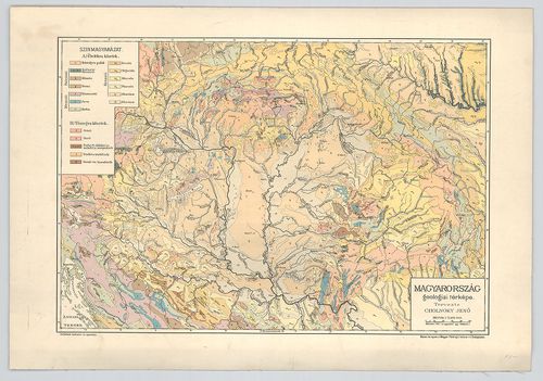
| Title | Magyarország geológiai térképe. |
984. Buda-Pest vidéke. – Umgebungen von Ofen und Pest. [B IX b 24]
Institute and Museum of Military History •
B IX b
•
B IX Ausztria–Magyarország
•
B I–XV. Európa
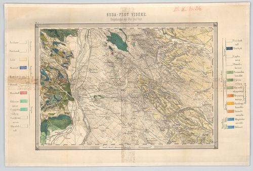
| Title | Buda-Pest vidéke. – Umgebungen von Ofen und Pest. |
985. Hypsometrische Karte der Steiermark. [B IX b 25]
Institute and Museum of Military History •
B IX b
•
B IX Ausztria–Magyarország
•
B I–XV. Európa
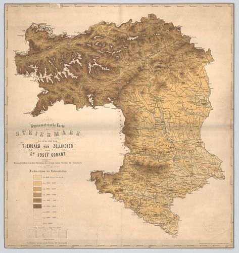
| Title | Hypsometrische Karte der Steiermark. |
| Main title | Stájerország hipszometrikus áttekintő térképe. |
986. Hypsometrische Übersichts Karte des Königreiches Böhmen. [B IX b 27]
Institute and Museum of Military History •
B IX b
•
B IX Ausztria–Magyarország
•
B I–XV. Európa
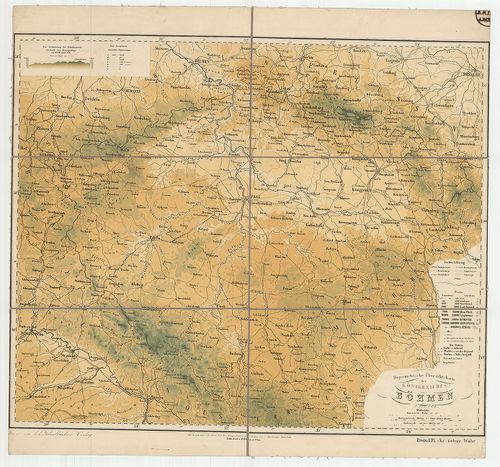
| Title | Hypsometrische Übersichts Karte des Königreiches Böhmen. |
| Main title | A Cseh Királyság hipszometrikus áttekintő térképe. |
987. Hypsometrische Übersichts Karte der Markgrafschaft Maehren u... [B IX b 28]
Institute and Museum of Military History •
B IX b
•
B IX Ausztria–Magyarország
•
B I–XV. Európa
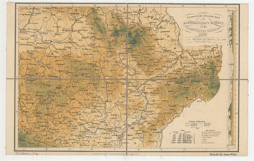
| Title | Hypsometrische Übersichts Karte der Markgrafschaft Maehren und des Herzogthumes Schlesien. |
| Main title | A Morva Őrgrófság és a Sziléziai Hercegség hipszometrikus áttekintő térképe 1880 körül. |
988. Hypsometrische Übersichts-Karte des Erzherzogthumes Oesterre... [B IX b 29]
Institute and Museum of Military History •
B IX b
•
B IX Ausztria–Magyarország
•
B I–XV. Európa
| Title | Hypsometrische Übersichts-Karte des Erzherzogthumes Oesterreich… Herzogthumes Salzburg. |
| Main title | Az Osztrák Főhercegség és Salzburg hipszometrikus áttekintő térképe. |
989. Hypsometrische Übersichts-Karte des Herzogthumes Steiermark… [B IX b 30]
Institute and Museum of Military History •
B IX b
•
B IX Ausztria–Magyarország
•
B I–XV. Európa
| Title | Hypsometrische Übersichts-Karte des Herzogthumes Steiermark… |
| Main title | Stájerország hipszometrikus áttekintő térképe. |
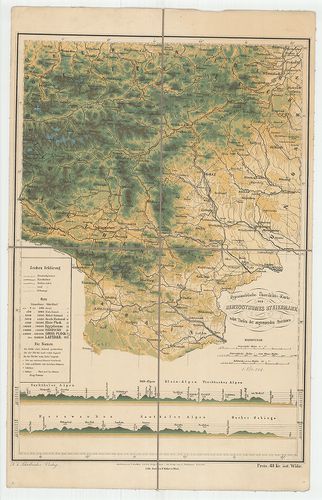
990. Hypsometrische Übersichts Karte der Gefürsteten Grafschaft T... [B IX b 31]
Institute and Museum of Military History •
B IX b
•
B IX Ausztria–Magyarország
•
B I–XV. Európa
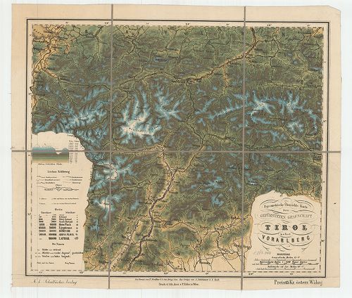
| Title | Hypsometrische Übersichts Karte der Gefürsteten Grafschaft Tirol nebst Vorarlberg. |
| Main title | Tirol és Vorarlberg hipszometrikus áttekintő térképe. |
991. Hypsometrische Übersichts Karte von den Herzogthümern Kärnte... [B IX b 32]
Institute and Museum of Military History •
B IX b
•
B IX Ausztria–Magyarország
•
B I–XV. Európa
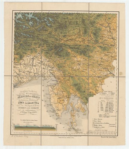
| Title | Hypsometrische Übersichts Karte von den Herzogthümern Kärnten und Krain von der… Görz und Gradiska… Istrien… Triest. |
| Main title | Karintia és Krajnai hercegség, Görz, (Gorizia) és Gradiska, Istria és Trieszt hipszometrikus áttekintő térképe. |
992. Hypsometrische Übersichts Karte des Königreiches Galizien mi... [B IX b 33]
Institute and Museum of Military History •
B IX b
•
B IX Ausztria–Magyarország
•
B I–XV. Európa
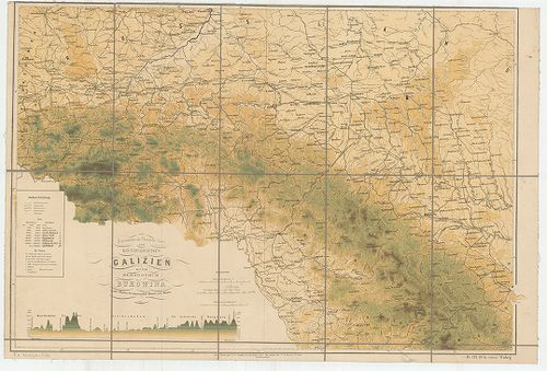
| Title | Hypsometrische Übersichts Karte des Königreiches Galizien mit dem Herzogthum Bukowina… |
| Main title | A Galícia Királyság és a Bukovina Hercegség hipszometrikus áttekintő térképe. |
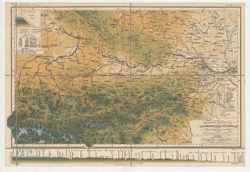
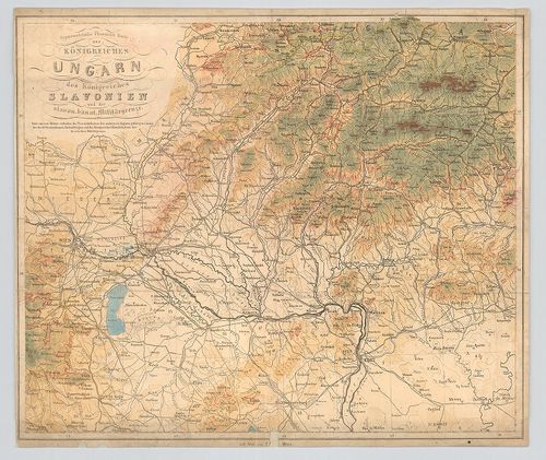
993. Hypsometrische Übersichts Karte des Königreiches Ungarn des ... [B IX b 34]
Institute and Museum of Military History •
B IX b
•
B IX Ausztria–Magyarország
•
B I–XV. Európa
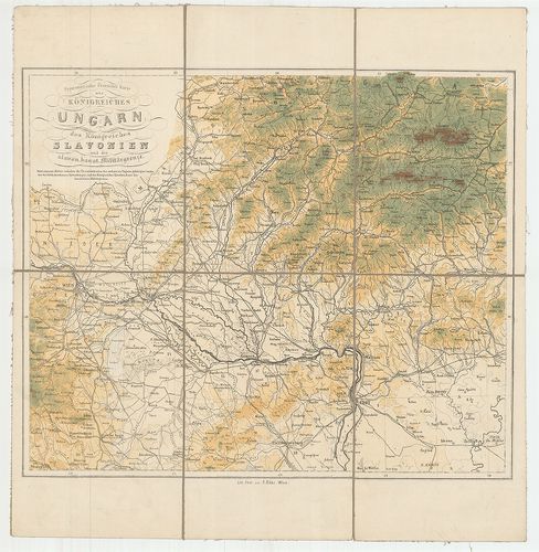
| Title | Hypsometrische Übersichts Karte des Königreiches Ungarn des Königreiches Slavonien und der slavon. banat. Militärgrenze. |
| Main title | A Magyar és Szlavon Királyság hipszometrikus áttekintő térképe. |
994. Hypsometrische Übersichts Karte des Königreiches Ungarn des ... [B IX b 34/1]
Institute and Museum of Military History •
B IX b
•
B IX Ausztria–Magyarország
•
B I–XV. Európa
| Title | Hypsometrische Übersichts Karte des Königreiches Ungarn des Königreiches Slavonien und der slavon. banat. Militärgrenze. |
| Main title | A Magyar és Szlavon Királyság hipszometrikus áttekintő térképe. |
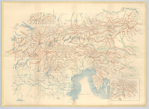
995. Orographische Übersicht des Südostens der österreichisch-ung... [B IX b 35]
Institute and Museum of Military History •
B IX b
•
B IX Ausztria–Magyarország
•
B I–XV. Európa
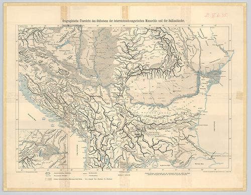
| Title | Orographische Übersicht des Südostens der österreichisch-ungarischen Monarchie und der Balkanländer. |
| Main title | Az Osztrák–Magyar Monarchia délkeleti részének és a Balkán-félsziget egy részének orográfiai térképe 1905-ben. |
996. Der Südwesten der österreichisch-ungarischen Monarchie mit d... [B IX b 35/1]
Institute and Museum of Military History •
B IX b
•
B IX Ausztria–Magyarország
•
B I–XV. Európa
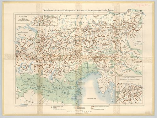
| Title | Der Südwesten der österreichisch-ungarischen Monarchie mit den angrenzenden Fremden Gebieten. |
| Main title | 2 Mt. 1. Südosttirol. (Délkelet-Tirol) |
| Subject | 2. Südtirol. (Dél-Tirol) |
997. [Az Osztrák–Magyar Monarchia déli része és a Balkán-félszige... [B IX b 35/2]
Institute and Museum of Military History •
B IX b
•
B IX Ausztria–Magyarország
•
B I–XV. Európa
| Title | [Az Osztrák–Magyar Monarchia déli része és a Balkán-félsziget északi részének hegyvonulatai.] |
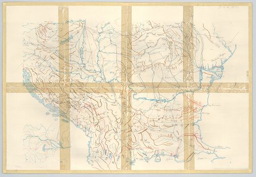
998. [Az Osztrák–Magyar Monarchia délkeleti része és a szomszédos... [B IX b 35/3]
Institute and Museum of Military History •
B IX b
•
B IX Ausztria–Magyarország
•
B I–XV. Európa
| Title | [Az Osztrák–Magyar Monarchia délkeleti része és a szomszédos területek hegyvonulatai.] |
| Main title | 2 mt. 1. [Délkelet-Tirol.] 2. [Dél-Tirol] |
999. Ausztrija. [B IX b 39]
Institute and Museum of Military History •
B IX b
•
B IX Ausztria–Magyarország
•
B I–XV. Európa
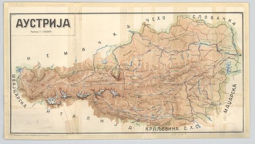
| Title | Ausztrija. |
| Main title | Ausztria hegyrajzi térképe. |
1000. Hypsometrische Karte von Gebiete des Schneeberges und der Ra... [B IX b 41]
Institute and Museum of Military History •
B IX b
•
B IX Ausztria–Magyarország
•
B I–XV. Európa
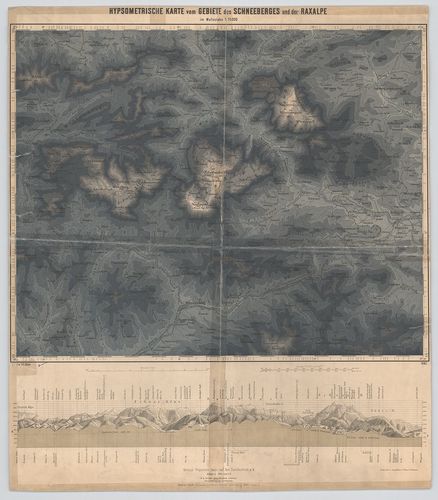
| Title | Hypsometrische Karte von Gebiete des Schneeberges und der Raxalpe. |
| Main title | A Schneeberg és a Raxalpe hegység hipszometrikus térképe 1883-ban. |