1561. [Magyarország.] Magyar Szent Korona Országainak vasúti hálóz... [B IX c 633]
Institute and Museum of Military History •
B IX c
•
B IX Ausztria–Magyarország
•
B I–XV. Európa
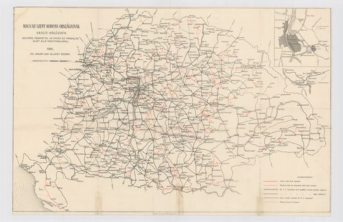
| Title | [Magyarország.] Magyar Szent Korona Országainak vasúti hálózata. (Különös tekintettel az építés és tárgyalás alatt álló vasútvonalakra.) 1916. évi január havi állapot szerint. |
| Main title | Mt. [Budapest és környéke.] Üzemben lévő és építés alatt álló vasútvonalak bejelölve. |
1562. Mappa Geographico Limitanea in qua Imperiorum Caesarei et Ot... [B IX c 634]
Institute and Museum of Military History •
B IX c
•
B IX Ausztria–Magyarország
•
B I–XV. Európa
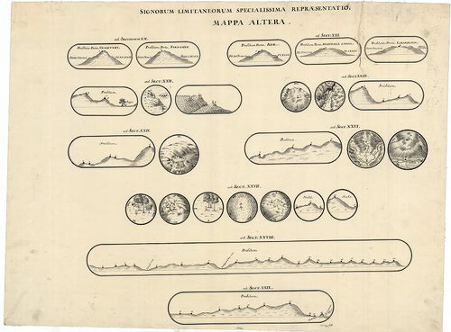
| Title | Mappa Geographico Limitanea in qua Imperiorum Caesarei et Ottomanici Confinia in almae pacis Carlovitzensis Congressu Decreta et a Duobus Utriusque Imperi Commissaris Intituta Solenni Expeditione… |
| Main title | A karlócai békekötésben meghatározott osztrák-török határvonal áttekintő térképe és felmérési szelvényei. |
1563. Telegraphen- und Telephonkarte (Verbindungskarte) für den Kr... [B IX c 635]
Institute and Museum of Military History •
B IX c
•
B IX Ausztria–Magyarország
•
B I–XV. Európa
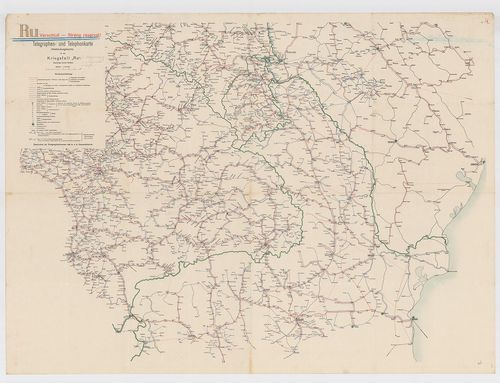
| Title | Telegraphen- und Telephonkarte (Verbindungskarte) für den Kriegsfall „Ru”. |
| Main title | Kelet-Magyarország telefonösszeköttetései a környező országokkal. |
1564. Erster Geometrischer Plan der Zwe˙en Pradien Horgosch und St... [B IX c 639]
Institute and Museum of Military History •
B IX c
•
B IX Ausztria–Magyarország
•
B I–XV. Európa
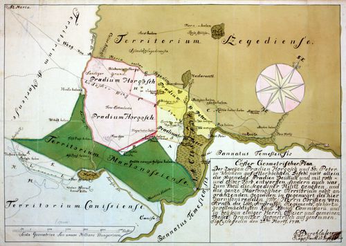
| Title | Erster Geometrischer Plan der Zwe˙en Pradien Horgosch und St. Peter, in Welchem auf Aller höchsten Befehl nicht allein die Obgemelde Preedien Deütlich und mit roth- und gelber Farb entworffen, Sondern auch was Zum theil die Segediner Militz genossen und das ganze Martonoscher Territorium nebst angranzende gegenden in Gegen wärt des hier Garnisonierenden. |
| Main title | Horgoš és Martonoš első felmérésű térképe 1750-ben. |
1565. A Magyar Királyság és a katonai határőrvidék Pénzintézetei é... [B IX c 640]
Institute and Museum of Military History •
B IX c
•
B IX Ausztria–Magyarország
•
B I–XV. Európa
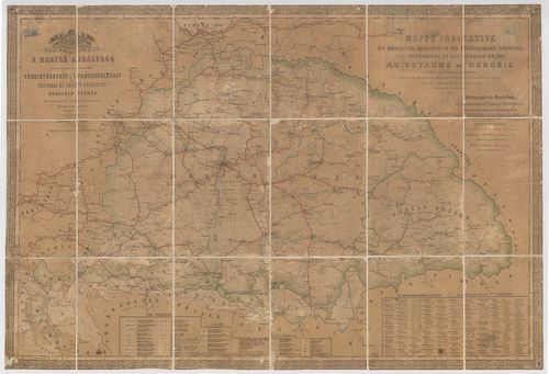
| Title | A Magyar Királyság és a katonai határőrvidék Pénzintézetei és Ipartársulatait úgy távirdai és vasúti hálózatát ábrázoló térképe. – Mappa Indicative des associations financieres et des établissiments industriels des telegraphes et des chemins de fer au Royaume de Hongrie. – Kartographische Darstellung der Gedinstitute und Industrie Gesellschaften glechzeitig Telegraphen und Eisenbahn Karte der von ungarischen Krone gehörigen Länder. |
1566. Mappa derjenigen Gränzen Linie, welche zwischen dem Königrei... [B IX c 642]
Institute and Museum of Military History •
B IX c
•
B IX Ausztria–Magyarország
•
B I–XV. Európa
| Title | Mappa derjenigen Gränzen Linie, welche zwischen dem Königreich Hungarn und dem Erzherzogthum Österreich unter der Enns bestehet… |
| Main title | A Magyar Királyság és Alsó-Ausztria határvidékének térképe 1754–1755-ben. |
1567. Plan der Ungarischen Mährischen und Schlesischen Granitz. [B IX c 662]
Institute and Museum of Military History •
B IX c
•
B IX Ausztria–Magyarország
•
B I–XV. Európa
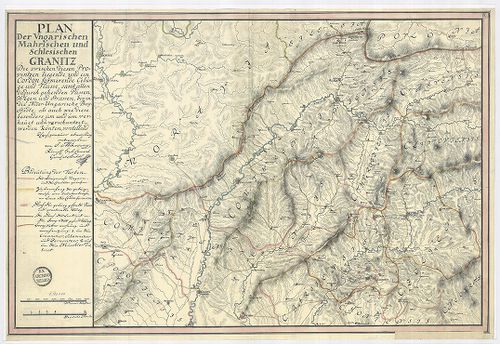
| Title | Plan der Ungarischen Mährischen und Schlesischen Granitz. |
| Main title | Magyar-morva, magyar-sziléziai határ térképe. [Határtérkép] |
1568. Magyarország vasúti térképe 1913. okt. 1. [B IX c 663]
Institute and Museum of Military History •
B IX c
•
B IX Ausztria–Magyarország
•
B I–XV. Európa
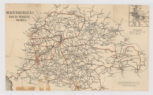
| Title | Magyarország vasúti térképe 1913. okt. 1. |
| Main title | Mt. [Budapest pályaudvarai.] |
1569. Magyarország úthálózatának távolsági térképe. – Carte Routié... [B IX c 664]
Institute and Museum of Military History •
B IX c
•
B IX Ausztria–Magyarország
•
B I–XV. Európa
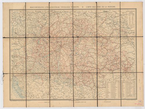
| Title | Magyarország úthálózatának távolsági térképe. – Carte Routiéres de la Hongrie. |
1570. A Magyar Automobil-Club Hivatalos Túratérképei. – Carte rout... [B IX c 665]
Institute and Museum of Military History •
B IX c
•
B IX Ausztria–Magyarország
•
B I–XV. Európa
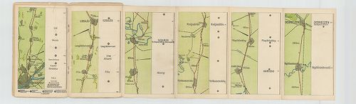
| Title | A Magyar Automobil-Club Hivatalos Túratérképei. – Carte routiére offic. de l’Automibile Club de Hongrie. – Offiz. Touren-Karten des Ungaricshen Automobil-Clubs. |
| Main title | 9. Budapest–Cegléd–Szolnok–Debrecen. 10. Budapest–Kecskemét–Szeged. 11. Budapest–Szolnok, Békéscsaba–Arad. 14. Debreczen–Nagyvárad–Királyhágó–Kolozsvár 15. Kolozsvár–Marosvásárhely –Brassó. 16. Szeged–Temesvár–Lugus–Orsova. 19. Debreczen–Nagyvárad–Arad–Temesvár. |
1571. Magyarország és Horvát-Szlavonország úthálózati térképe. – C... [B IX c 666]
Institute and Museum of Military History •
B IX c
•
B IX Ausztria–Magyarország
•
B I–XV. Európa
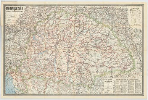
| Title | Magyarország és Horvát-Szlavonország úthálózati térképe. – Carte Routiére de Hongrie et Croatie-Slavonie. |
1572. Theatre de la Guerre dans le Bannat de Temesvár. [B IX c 677]
Institute and Museum of Military History •
B IX c
•
B IX Ausztria–Magyarország
•
B I–XV. Európa
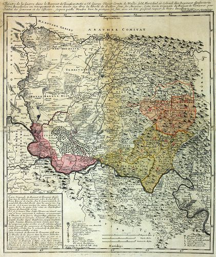
| Title | Theatre de la Guerre dans le Bannat de Temesvár. |
| Main title | A Temesi-Bánság hadszíntere 1738-ban. |
1573. Dislocations Carte von Ungarn de Anno 1781. [B IX c 685]
Institute and Museum of Military History •
B IX c
•
B IX Ausztria–Magyarország
•
B I–XV. Európa
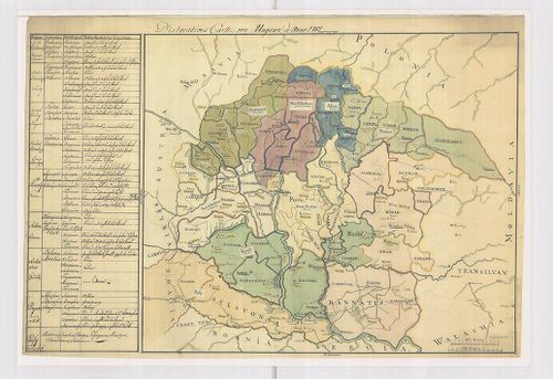
| Title | Dislocations Carte von Ungarn de Anno 1781. |
| Main title | Magyarország diszlokációs térképe 1781-ben. |
1574. Strassen-Karte des Königreiches Ungarn. [B IX c 690]
Institute and Museum of Military History •
B IX c
•
B IX Ausztria–Magyarország
•
B I–XV. Európa
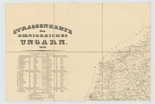
| Title | Strassen-Karte des Königreiches Ungarn. |
| Main title | Magyarország úttérképe 1832-ben. |
1575. [Magyarország.] Magyar-Ország és a hozzá kapcsolt Részek Had... [B IX c 691]
Institute and Museum of Military History •
B IX c
•
B IX Ausztria–Magyarország
•
B I–XV. Európa
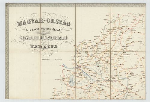
| Title | [Magyarország.] Magyar-Ország és a hozzá kapcsolt Részek Hadi-Útvonali térképe. |
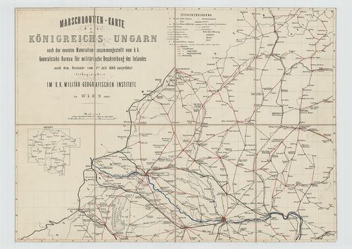
1576. Marschrouten-Karte des Königreiches Ungarn nach den neuesten... [B IX c 696]
Institute and Museum of Military History •
B IX c
•
B IX Ausztria–Magyarország
•
B I–XV. Európa
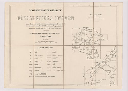
| Title | Marschrouten-Karte des Königreiches Ungarn nach den neuesten Materialien zusammengestellt… vom 1-ten Juli. 1868. |
| Main title | Magyarország menettérképe 1868-ban. |
1577. Marschrouten-Karte des Königreichs Ungarn nach den neuesten ... [B IX c 697]
Institute and Museum of Military History •
B IX c
•
B IX Ausztria–Magyarország
•
B I–XV. Európa
| Title | Marschrouten-Karte des Königreichs Ungarn nach den neuesten Materialien zusammengestellt… vom 1-ten Juli 1869. |
| Main title | Magyarország menettérképe 1869-ben. Az úttávolságok bejelölve. |
1578. [Magyarország.] A Magyar Korona államterületének honvédségi ... [B IX c 698]
Institute and Museum of Military History •
B IX c
•
B IX Ausztria–Magyarország
•
B I–XV. Európa
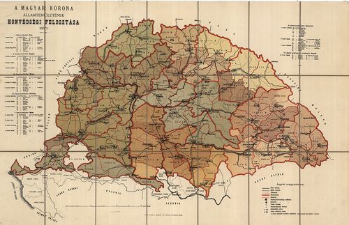
| Title | [Magyarország.] A Magyar Korona államterületének honvédségi felosztása. |
1579. [Magyarország.] A Magyar Korona Államterületének közigazgatá... [B IX c 698/1]
Institute and Museum of Military History •
B IX c
•
B IX Ausztria–Magyarország
•
B I–XV. Európa
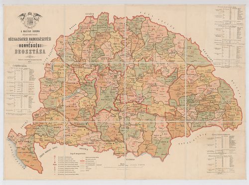
| Title | [Magyarország.] A Magyar Korona Államterületének közigazgatási Hadkiegészítési és Honvédségi beosztása. |
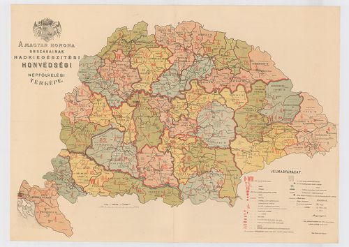
1580. [Magyarország.] A Magyar Korona Országainak Hadkiegészítési ... [B IX c 699]
Institute and Museum of Military History •
B IX c
•
B IX Ausztria–Magyarország
•
B I–XV. Európa
| Title | [Magyarország.] A Magyar Korona Országainak Hadkiegészítési és Honvédségi térképe. |