1881. [A törökellenes magyarországi határvédelem térképe.] [B IX c 1407]
Institute and Museum of Military History •
B IX c
•
B IX Ausztria–Magyarország
•
B I–XV. Európa
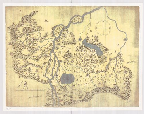
| Title | [A törökellenes magyarországi határvédelem térképe.] |
1882. [Mappa Mercantilis] - Mappa Geographica facta in usum Commer... [B IX c 1408]
Institute and Museum of Military History •
B IX c
•
B IX Ausztria–Magyarország
•
B I–XV. Európa
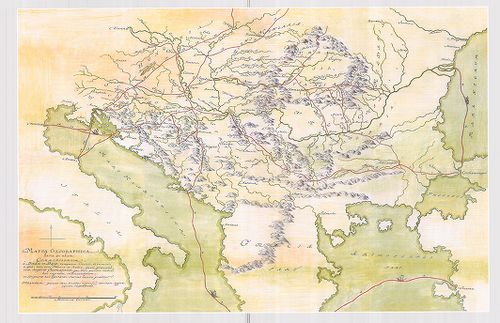
| Title | [Mappa Mercantilis] - Mappa Geographica facta in usum Commerciorum. |
| Main title | Földrajzi térkép, amely kereskedők használatára készült.[Kereskedelmi térkép]. |
1883. A Fekete-Körös menti táj 1822. [B IX c 1410]
Institute and Museum of Military History •
B IX c
•
B IX Ausztria–Magyarország
•
B I–XV. Európa
| Title | A Fekete-Körös menti táj 1822. |
1884. A Duna–Tisza köze élőhelytérképe a 19. sz. végén. [B IX c 1411]
Institute and Museum of Military History •
B IX c
•
B IX Ausztria–Magyarország
•
B I–XV. Európa
| Title | A Duna–Tisza köze élőhelytérképe a 19. sz. végén. |
1885. Magyarország vízierői 1897–1903. évi fölvételének körébe von... [B IX c 1412]
Institute and Museum of Military History •
B IX c
•
B IX Ausztria–Magyarország
•
B I–XV. Európa
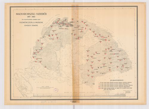
| Title | Magyarország vízierői 1897–1903. évi fölvételének körébe vont vízmérceállomások átnézeti térképe. |
1886. Magyarország (X–XI. sz.) [B IX c 1413]
Institute and Museum of Military History •
B IX c
•
B IX Ausztria–Magyarország
•
B I–XV. Európa
| Title | Magyarország (X–XI. sz.) |
| Main title | 1 mt: Egyházmegyék 1038-ban |
1887. Magyarország a Hunyadiak és Jagellók korában (1437×1526.) [B IX c 1414]
Institute and Museum of Military History •
B IX c
•
B IX Ausztria–Magyarország
•
B I–XV. Európa
| Title | Magyarország a Hunyadiak és Jagellók korában (1437×1526.) |
| Main title | 4 Mt.: 1. Várnai csata |
| Subject | 2. A nándorfehérvári csata |
1888. A függetlenségi harcok (Magyarország a XVII. században) [B IX c 1415]
Institute and Museum of Military History •
B IX c
•
B IX Ausztria–Magyarország
•
B I–XV. Európa
| Title | A függetlenségi harcok (Magyarország a XVII. században) |
1889. Az Osztrák–Magyar Monarchia (1867–1918.) [B IX c 1416]
Institute and Museum of Military History •
B IX c
•
B IX Ausztria–Magyarország
•
B I–XV. Európa
| Title | Az Osztrák–Magyar Monarchia (1867–1918.) |
| Main title | 2 mt. 1. O.–M nemzetiségei 1910. |
| Subject | 2. A vasúthálózat fejlődése Mo. |
1890. A Pilis és Dobogókő környéke [B IX c 1418]
Institute and Museum of Military History •
B IX c
•
B IX Ausztria–Magyarország
•
B I–XV. Európa
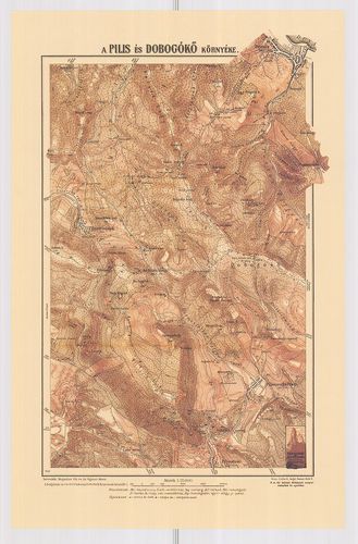
| Title | A Pilis és Dobogókő környéke |
1891. A gazdaságok területének megoszlása nagyságkategóriák szerin... [B IX c 1419]
Institute and Museum of Military History •
B IX c
•
B IX Ausztria–Magyarország
•
B I–XV. Európa
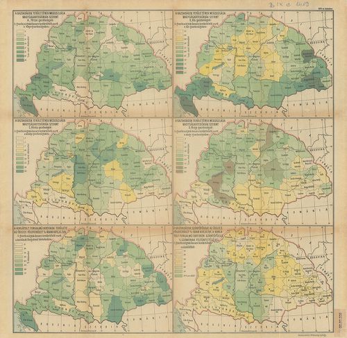
| Title | A gazdaságok területének megoszlása nagyságkategóriák szerint. 6 térkép, statisztikai adatokkal. |
1892. Magyarország gazdaságföldrajzi térképe. [B IX c 1420]
Institute and Museum of Military History •
B IX c
•
B IX Ausztria–Magyarország
•
B I–XV. Európa
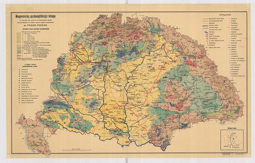
| Title | Magyarország gazdaságföldrajzi térképe. |
1893. Limitum post Pacem Carlovitcensem A MDCXCVIII. Mappa Geograp... [B IX c 1421]
Institute and Museum of Military History •
B IX c
•
B IX Ausztria–Magyarország
•
B I–XV. Európa
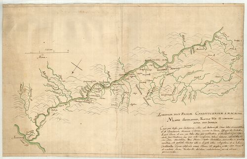
| Title | Limitum post Pacem Carlovitcensem A MDCXCVIII. Mappa Geographica, Tractus Unnae fl. Limitanei inter duo Imperia. |
| Main title | Az 1698. (sic!) évi Karlócai békeszerződés utáni határok földrajzi térképe, amely az Una folyónak a két birodalom közötti határszakaszát ábrázolja. Határtérkép. |
1894. Mappa Geographica Unnae Fluvii Tractum, a Kastanovitz, usque... [B IX c 1422]
Institute and Museum of Military History •
B IX c
•
B IX Ausztria–Magyarország
•
B I–XV. Európa
| Title | Mappa Geographica Unnae Fluvii Tractum, a Kastanovitz, usque ad Monasterii rudera, item, Controversum adhuc Territorium Novense, exhibens. |
| Main title | Geográfiai térkép, amely az Una folyót Kastanovitztól a kolostor romjaiig, valamint a még vitatott novi-i területet ábrázolja. Határtérkép. |
1895. Mappa Geographica; Lineam, inter utrumque Imperium, Limitane... [B IX c 1423]
Institute and Museum of Military History •
B IX c
•
B IX Ausztria–Magyarország
•
B I–XV. Európa
| Title | Mappa Geographica; Lineam, inter utrumque Imperium, Limitaneam, a Confluxu Savi et Unae ffl., ad montem usque Popinam, ad Mare usque Adriaticum; Compendiose exhibens |
| Main title | Földrajzi térkép, amely a két birodalom határvonalát a Száva és az Una folyók torkolatától a Popina hegyig, és innen a velencei fennhatóságú területekig, egészen az Adriai tengerig, vázlatosan bemutatja. Határtérkép. |
1896. Mappa Geographica Tractus Unae fl. Limitanei inter Duo imper... [B IX c 1424]
Institute and Museum of Military History •
B IX c
•
B IX Ausztria–Magyarország
•
B I–XV. Európa
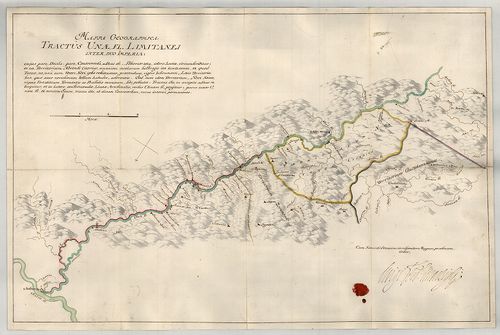
| Title | Mappa Geographica Tractus Unae fl. Limitanei inter Duo imperia... |
| Main title | Földrajzi térkép, amely az Una folyónak a két birodalom közötti szakaszát ábrázolja. Határtérkép. |
1897. Mappa Geographica Tractus Limitanei a Sluin, usque ad, Tripl... [B IX c 1425]
Institute and Museum of Military History •
B IX c
•
B IX Ausztria–Magyarország
•
B I–XV. Európa
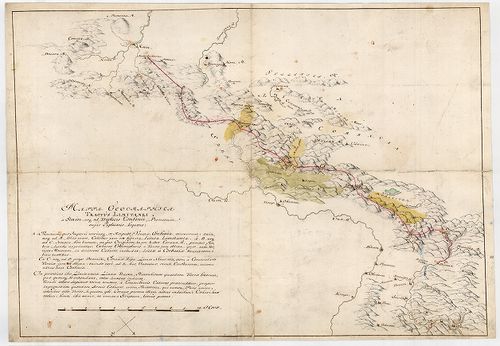
| Title | Mappa Geographica Tractus Limitanei a Sluin, usque ad, Triplicis Confinii, Punctum... |
| Main title | Szluintól a hármas határ pontjáig terjedő határszakasz geográfiai térképe... Határtérkép. |
1898. Mappa Geographica, qua Praecautio contra Pestem instituenda ... [B IX c 1426]
Institute and Museum of Military History •
B IX c
•
B IX Ausztria–Magyarország
•
B I–XV. Európa
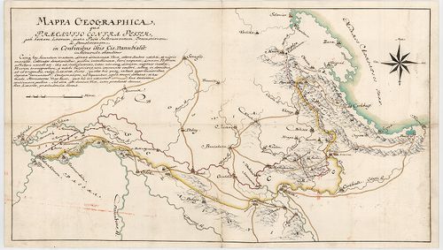
| Title | Mappa Geographica, qua Praecautio contra Pestem instituenda [...] ostenditur... |
| Main title | Földrajzi térkép, amelyen a pestis terjedésének megelőzésére hozandó intézkedéseket mutatjuk meg. Határtérkép. |
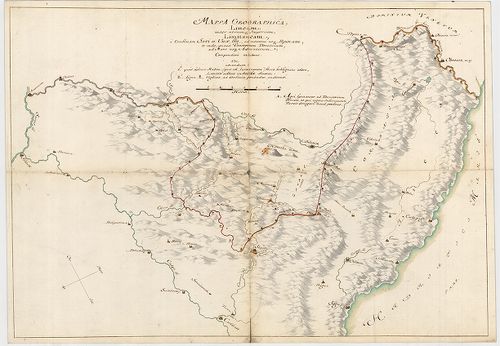
1899. Mappa Geograph. Croatiae Inferior. Inter Unam, Colapim, et S... [B IX c 1427]
Institute and Museum of Military History •
B IX c
•
B IX Ausztria–Magyarország
•
B I–XV. Európa
| Title | Mappa Geograph. Croatiae Inferior. Inter Unam, Colapim, et Savum, sitt., qua ostenditur, quid demolitio Novi, importare possit... |
1900. Mappa Geographica Lineae, ad Coranam, fl. Limitaneae, usque ... [B IX c 1428]
Institute and Museum of Military History •
B IX c
•
B IX Ausztria–Magyarország
•
B I–XV. Európa
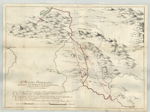
| Title | Mappa Geographica Lineae, ad Coranam, fl. Limitaneae, usque ad Jeszera [sic], stabilitae, tractum exhibens... |
| Main title | Földrajzi térkép, amely a Corana folyó mentén Jeszeraig futó végleges határszakaszt ábrázolja. Határtérkép. |