381. Strategische-Übersichts-Karte [von Südtirol und Norditalien]... [H IV c 106]
Institute and Museum of Military History •
H IV c (1841–1913)
•
H IV Újabbkori háborúk
•
H Háborúk
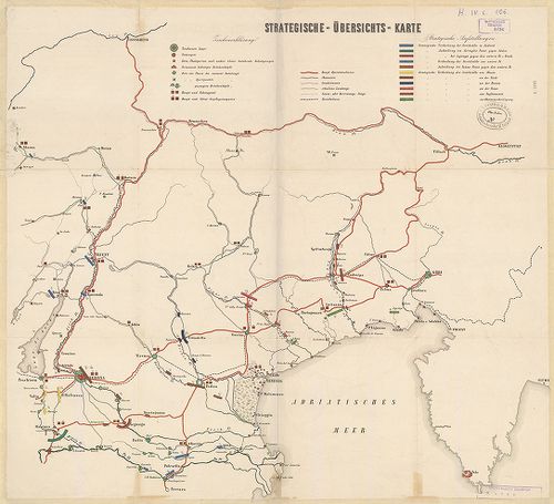
| Title | Strategische-Übersichts-Karte [von Südtirol und Norditalien]. |
| Main title | Dél-Tirol és Észak-Itália térségének vázlatos hadműveleti térképe. (Olasz–osztrák háború. Megerősített helyek, hadállások, felvonulási utak. |
382. Az olaszországi magyar légió [Garibaldi szicíliai és dél-itá... [H IV c 109]
Institute and Museum of Military History •
H IV c (1841–1913)
•
H IV Újabbkori háborúk
•
H Háborúk
| Title | Az olaszországi magyar légió [Garibaldi szicíliai és dél-itáliai hadjáratában] 1859–1867. |
| Main title | A légió állomáshelyei, harcai és útvonalai Palermóig. |
383. Schlacht von Solferino am 24ten Juni 1859. [H IV c 112]
Institute and Museum of Military History •
H IV c (1841–1913)
•
H IV Újabbkori háborúk
•
H Háborúk
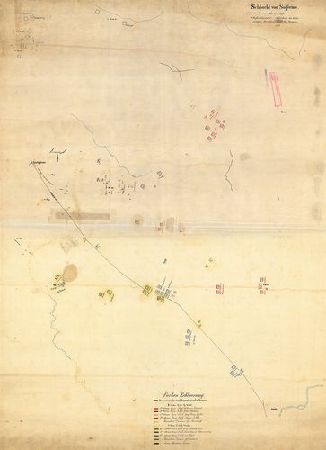
| Title | Schlacht von Solferino am 24ten Juni 1859. |
| Main title | A solferinoi (Ol.) csata vázlatos helyszínrajza 1859. jún. 24. – A francia–szárd és az osztrák csapatok hadállásai. A csata hat mozzanata. |
384. Az utolsó pápai hadsereg 1860. Áttekintési térk. [H IV c 113]
Institute and Museum of Military History •
H IV c (1841–1913)
•
H IV Újabbkori háborúk
•
H Háborúk
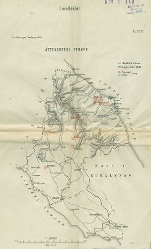
| Title | Az utolsó pápai hadsereg 1860. Áttekintési térk. |
| Main title | A Rimini–Gaeta (Ol.) közötti térség, mint a piemonti és a pápai csapatok harcainak színtere 1860. Hadállások, útvonalak. |
385. Military map showing the marches of the United States forces... [H IV c 121]
Institute and Museum of Military History •
H IV c (1841–1913)
•
H IV Újabbkori háborúk
•
H Háborúk
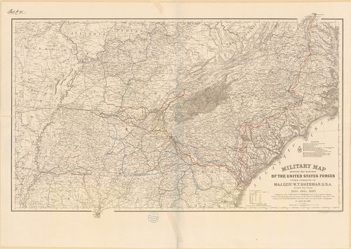
| Title | Military map showing the marches of the United States forces… during the years 1863., 1864., 1865. |
| Main title | Az észak-amerikai polgárháború hadjáratainak térképe 1863–65. A Sherman W. T. tábornok parancsnokága alatt álló északi erők hadmozdulatai. |
386. Vereinigten Staaten von Amerika. (Secessionskrieg.) [H IV c 122]
Institute and Museum of Military History •
H IV c (1841–1913)
•
H IV Újabbkori háborúk
•
H Háborúk
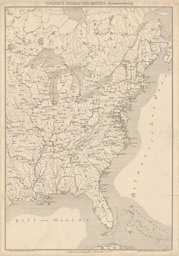
| Title | Vereinigten Staaten von Amerika. (Secessionskrieg.) |
| Main title | Amerikai Egyesült Államok K-i részének térképe az 1860-as években. A polgárháború hadszíntere. |
387. Operationplan zum Feldzug des General Sherman in Georgia in ... [H IV c 123]
Institute and Museum of Military History •
H IV c (1841–1913)
•
H IV Újabbkori háborúk
•
H Háborúk
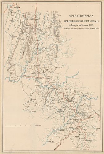
| Title | Operationplan zum Feldzug des General Sherman in Georgia in Sommer 1864. |
| Main title | Sherman tábornok hadjáratának térképe Georgiában (USA) 1864 nyarán. |
388. [Studien über Kriegführung auf Grundlage des Nordamerikanisc... [H IV c 124]
Institute and Museum of Military History •
H IV c (1841–1913)
•
H IV Újabbkori háborúk
•
H Háborúk
| Title | [Studien über Kriegführung auf Grundlage des Nordamerikanischen Secessionskreiges in Virginien.] |
| Main title | 1. Skizze des Kriegsschauplatzes im Secessionskriege. |
| Subject | 2. Virginien und nördlich angrenzende Gebiete |
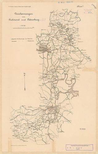
389. Military maps illustrating the Operations of the armies of t... [H IV c 125]
Institute and Museum of Military History •
H IV c (1841–1913)
•
H IV Újabbkori háborúk
•
H Háborúk
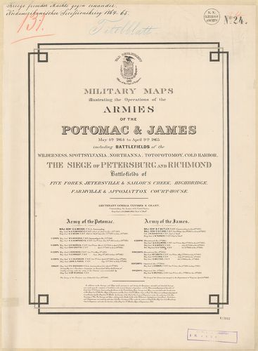
| Title | Military maps illustrating the Operations of the armies of the Potomac and James May 4th 1864 to April 9th 1865 including battlefields. |
390. Central Virginia showing lieut. Genl U. S. Grants campaing… ... [H IV c 127]
Institute and Museum of Military History •
H IV c (1841–1913)
•
H IV Újabbkori háborúk
•
H Háborúk
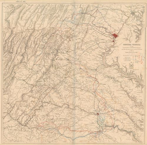
| Title | Central Virginia showing lieut. Genl U. S. Grants campaing… in 1864–65. |
| Main title | Közép-Virginia (USA): Grant tábornok hadműveleteinek színtere az észak-amerikai polgárháborúban 1864–65. A hadtestek felvonulási útjai. |
391. Map of the Battlefield of Chattanooga… 1864. [H IV c 134]
Institute and Museum of Military History •
H IV c (1841–1913)
•
H IV Újabbkori háborúk
•
H Háborúk
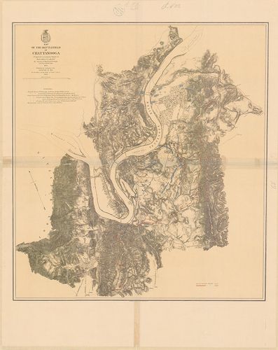
| Title | Map of the Battlefield of Chattanooga… 1864. |
| Main title | A chattanoogai (USA) ütközet helyszíne 1864. (Észak-amerikai polgárháború.) Az északiak és a déliek hadállásai, sáncai. A város alaprajzban. Útvonalak, átkelőhelyek a Tennessee-folyón. |
392. Battlefield in front of Franklin, Tenn… November 30th 1864. [H IV c 136]
Institute and Museum of Military History •
H IV c (1841–1913)
•
H IV Újabbkori háborúk
•
H Háborúk
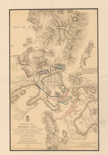
| Title | Battlefield in front of Franklin, Tenn… November 30th 1864. |
| Main title | A Franklin (USA, Tennesy) város melletti csata helyszíne 1864. (Észak-Amerikai polgárháború.) Az északiak és déliek hadállásai, sáncai. A város alaprajzban. Útvonalak. |
393. Map of the Battle Field of Gettysburg july 1st. 2nd. 3rd. 18... [H IV c 137]
Institute and Museum of Military History •
H IV c (1841–1913)
•
H IV Újabbkori háborúk
•
H Háborúk
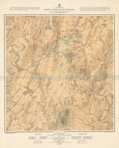
| Title | Map of the Battle Field of Gettysburg july 1st. 2nd. 3rd. 1863. |
| Main title | A gettysburgi (USA) csata (Pennsylvania) helyszínrajza. 1863. Az északi és déli haderők állásának három szakasza az észak-amerikai háborúban. Parancsnokok nevei. |
394. Battlefields in front of Nashville… December 15th and 16th 1... [H IV c 138]
Institute and Museum of Military History •
H IV c (1841–1913)
•
H IV Újabbkori háborúk
•
H Háborúk
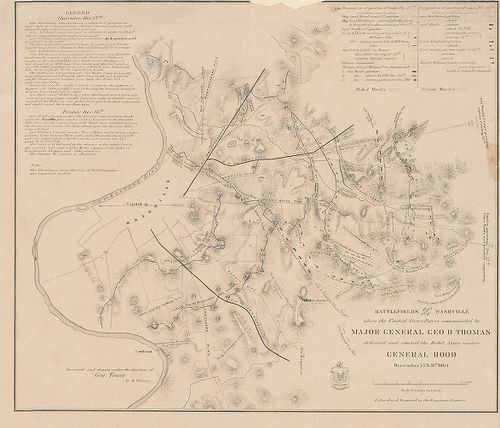
| Title | Battlefields in front of Nashville… December 15th and 16th 1864. |
| Main title | A Nashville (USA) melletti csata helyszíne 1864. (Észak-amerikai polgárháború.) Az északiak és déliek hadállásai. Útvonalak. Ismertetés. |
395. Topographical map of the approaches and defendes of Knoxvill... [H IV c 144]
Institute and Museum of Military History •
H IV c (1841–1913)
•
H IV Újabbkori háborúk
•
H Háborúk
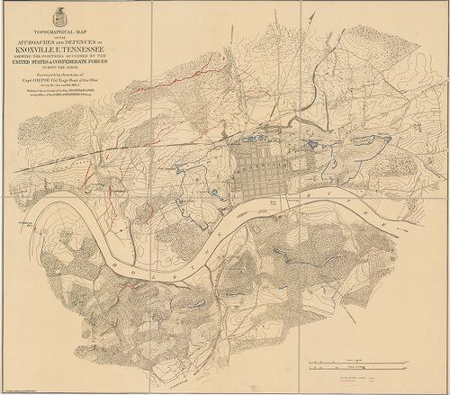
| Title | Topographical map of the approaches and defendes of Knoxville E. Tennessee Shewing the positions occupied by the United States and Confederate Forces. During the Siege. |
| Main title | Knoxville (USA, Tenn.) ostromának helyszínrajza 1863–64. (Észak-amerikai polgárháború.) Az északiak és déliek hadállásai, kiserődei. A város alaprajzban. Útvonalak. |
396. Map of the siege of Vicksburg, Missby the U. S. forces… [H IV c 146]
Institute and Museum of Military History •
H IV c (1841–1913)
•
H IV Újabbkori háborúk
•
H Háborúk
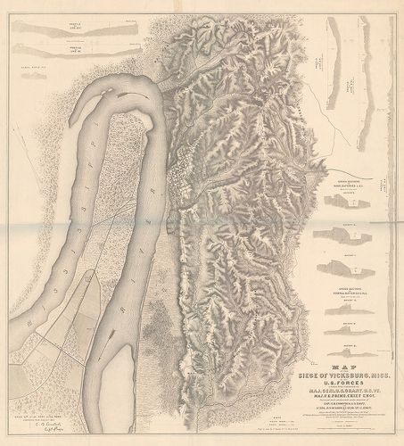
| Title | Map of the siege of Vicksburg, Missby the U. S. forces… |
| Main title | Mt.: metszetek. |
| Subject | Vicksburg (USA, Miss.) ostromának helyszínrajza 1863. (Észak-amerikai polgárháború.) Az északiak és déliek hadállásai. A város alaprajzban. Útvonalak. |
397. A., Sketch of Vicinity of Fort Fisher, 1865. (Fort Fisher (U... [H IV c 154]
Institute and Museum of Military History •
H IV c (1841–1913)
•
H IV Újabbkori háborúk
•
H Háborúk
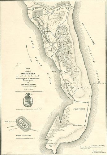
| Title | A., Sketch of Vicinity of Fort Fisher, 1865. (Fort Fisher (USA) környékének vázlatos helyszínrajza 1865.) Sáncok, utak, hadállások. |
| Main title | Mt.: a Fort Buchanan alaprajzban. |
| Subject | B., Plan and sections of Fort Fisker 1865. (Fort Fisher védőművei alaprajzban.) |
398. Military map… Harper’s Ferry Va… 1863. [H IV c 155]
Institute and Museum of Military History •
H IV c (1841–1913)
•
H IV Újabbkori háborúk
•
H Háborúk
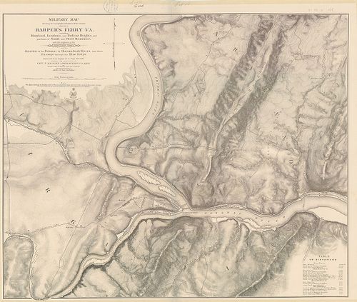
| Title | Military map… Harper’s Ferry Va… 1863. |
| Main title | Harpers Ferry V. (USA) térségének vázlatos térképe, 1863. (Észak-amerikai polgárháború.) Hadállások, kiserődök. Útvonalak. Kimutatás távolságokról. |
399. Fort Sumter. South Carolina, at the time of its capture febr... [H IV c 163]
Institute and Museum of Military History •
H IV c (1841–1913)
•
H IV Újabbkori háborúk
•
H Háborúk
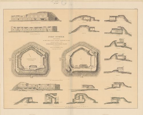
| Title | Fort Sumter. South Carolina, at the time of its capture february 18th 1865. Showing the Effects of teh Bombardment from Morris Island. |
| Main title | Fort Sumter (Dél-Carolina, USA erőd) bevétele után, 1865. 2 alaprajz az erőd védelmi berendezéseiről és 16 metszet a bombázások hatásáról. (Észak-amerikai polgárháború.) |
400. Der Kriegsschauplatz zwischen Felnsburg, Apenrade, Düppel un... [H IV c 203]
Institute and Museum of Military History •
H IV c (1841–1913)
•
H IV Újabbkori háborúk
•
H Háborúk
| Title | Der Kriegsschauplatz zwischen Felnsburg, Apenrade, Düppel und der Insel Alsen. |
| Main title | Apenrade (Ábenrá, D.) – Flensburg (No.) – Düppel (Dybböl, D.) és Als-sziget (D.) közötti térség. A német–dán háború helyszíntere 1849. Megerősített helyek, összekötő utak. |