3281. Carta Idrografica Stradale Amministrativa Consorziale della ... [B VII b 29]
Institute and Museum of Military History •
B VII b
•
B VII Olaszország
•
B I–XV. Európa
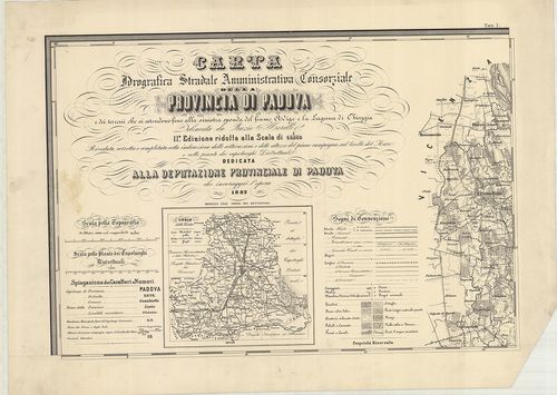
| Title | Carta Idrografica Stradale Amministrativa Consorziale della Provincia di Padova… |
| Main title | 8 mt.: 1. Cittadella. 2. Camposampiero. 3. Monselice. 4. Montagnana. 5. Este. 6. Padova. 7. Conselve. 8. Piove. |
| Subject | Padova tartományvízrajzi, út- és közigazgatási térképe 1882-ben. |
3282. Atlante Marittimo del Regno di Napoli… [B VII b 30]
Institute and Museum of Military History •
B VII b
•
B VII Olaszország
•
B I–XV. Európa
| Title | Atlante Marittimo del Regno di Napoli… |
| Main title | A Nápolyi Királyság és Szicília partvidékének térképe 1785-ben. |
3283. Icon sinus Baiarum uti nunc videtur… [B VII b 35/10]
Institute and Museum of Military History •
B VII b
•
B VII Olaszország
•
B I–XV. Európa
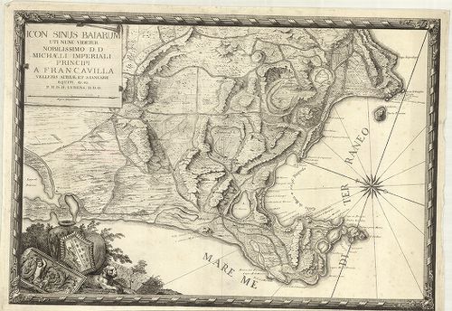
| Title | Icon sinus Baiarum uti nunc videtur… |
| Main title | A Pozzuoli-öböl (Nápolytól Ny-ra) térképe az 1720-as évek körül. |
3284. Il Golfo di Spezia. [B VII b 35/12]
Institute and Museum of Military History •
B VII b
•
B VII Olaszország
•
B I–XV. Európa
| Title | Il Golfo di Spezia. |
| Main title | Mt.: Citta e Rada di Viareggio nel Ducato di Lucca. |
| Subject | A Speziai-öböl térképe 1820 körül. |
3285. Plan du Golfe de la Spezia Côtes d’ Italia. (Duché de Génes)... [B VII b 35/13]
Institute and Museum of Military History •
B VII b
•
B VII Olaszország
•
B I–XV. Európa
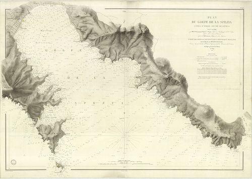
| Title | Plan du Golfe de la Spezia Côtes d’ Italia. (Duché de Génes). |
| Main title | A Speziai-öböl térképe 1846–67-ben. |
3286. Laguna Veneta. Mappa topografica. [B VII b 36/2]
Institute and Museum of Military History •
B VII b
•
B VII Olaszország
•
B I–XV. Európa
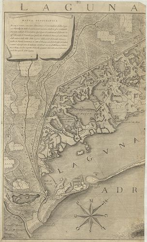
| Title | Laguna Veneta. Mappa topografica. |
| Main title | Mt.: [Venezia.] |
| Subject | A Velence-i laguna topográfiai térképe 1780-ban. |
3287. Carta topografica della laguna di Venezia e del territorio c... [B VII b 36/6]
Institute and Museum of Military History •
B VII b
•
B VII Olaszország
•
B I–XV. Európa
| Title | Carta topografica della laguna di Venezia e del territorio conterminante fino a 37. chilometri. Nono Congresso. |
| Main title | A Velence-i laguna és tágabb környékének topográfiai térképe 1847-ben. |
3288. Karte der Lagunen von Venedig und der adriatischen Meeresküs... [B VII b 36/10]
Institute and Museum of Military History •
B VII b
•
B VII Olaszország
•
B I–XV. Európa
| Title | Karte der Lagunen von Venedig und der adriatischen Meeresküste zwischen der Piave und den Po Mündungen… |
| Main title | A Velence-i laguna és a Piave–Pó-torkolat közti tengerpart térképe a tágabb környékkel 1860-ban. |
3289. Plan des Adda-Flus[s], von Trezzo bis zu dem Einflus[s] in P... [B VII b 37]
Institute and Museum of Military History •
B VII b
•
B VII Olaszország
•
B I–XV. Európa
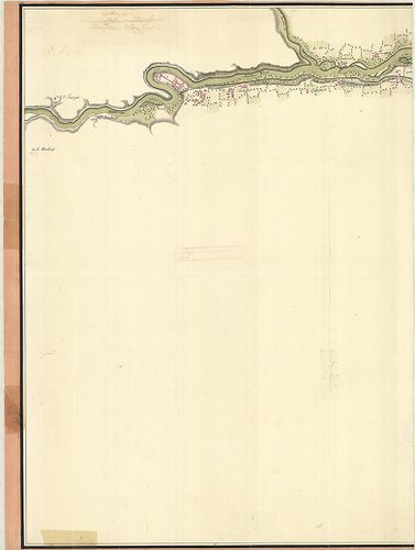
| Title | Plan des Adda-Flus[s], von Trezzo bis zu dem Einflus[s] in Poo dessen Lauff sich durch das Mailendische und Lodisanische erstrecket. |
| Main title | Az Adda folyó és közvetlen környéke (Trezzo-tól a Pó-ig.) 1750 körül. |
3290. Mittelmeer Westküste von Italien Capo Circeo bis Capo Palinu... [B VII b 38]
Institute and Museum of Military History •
B VII b
•
B VII Olaszország
•
B I–XV. Európa
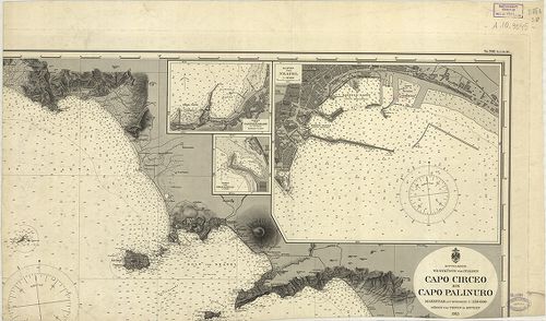
| Title | Mittelmeer Westküste von Italien Capo Circeo bis Capo Palinuro. Nr. 506. (Tit. V. Nr. 94.) |
| Main title | 3 mt.: 1. Hafen von Neapel (a Nápoly-i kikötő). |
| Subject | 2. Hafen von Castellamare di Stabia. |
3291. Dissegno fatto per le Regolation della Piaue et altri Fiumi ... [B VII b 68]
Institute and Museum of Military History •
B VII b
•
B VII Olaszország
•
B I–XV. Európa
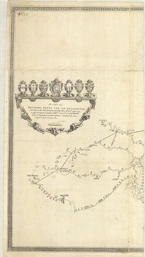
| Title | Dissegno fatto per le Regolation della Piaue et altri Fiumi … |
| Main title | A Piave és a betorkolló folyók szabályozásának térképe 1633–39-ben. |
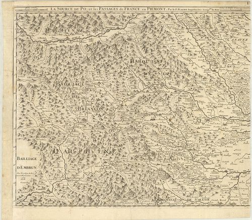
3292. Corso del Po per la Lombardia dalle sve fonti sino al Mare… [B VII b 72]
Institute and Museum of Military History •
B VII b
•
B VII Olaszország
•
B I–XV. Európa
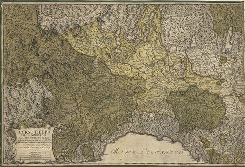
| Title | Corso del Po per la Lombardia dalle sve fonti sino al Mare… |
| Main title | A Pó-síkság és a környező részek térképe 1733-ban. |
3293. Mappa del Corso e stato presentaneo del fiume Po in Vicinanz... [B VII b 74]
Institute and Museum of Military History •
B VII b
•
B VII Olaszország
•
B I–XV. Európa
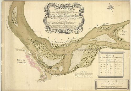
| Title | Mappa del Corso e stato presentaneo del fiume Po in Vicinanza della Citta di Cremona … Közreműködött: Bernardino Mazzoni–Adamo du Ponte … |
| Main title | A Pó és környéke Cremona közelében 1726–28-ban. |
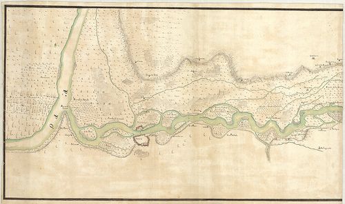
3294. Le Cours du Po. [B VII b 80]
Institute and Museum of Military History •
B VII b
•
B VII Olaszország
•
B I–XV. Európa
| Title | Le Cours du Po. |
| Main title | A Pó és környékének térképe 1703–1734-ben. |
3295. Dissegno delle valli et Isole del fiume Ticino delli 15 otto... [B VII b 103]
Institute and Museum of Military History •
B VII b
•
B VII Olaszország
•
B I–XV. Európa
| Title | Dissegno delle valli et Isole del fiume Ticino delli 15 ottobre 1681. |
| Main title | A Ticino folyó térképe 1681–1714-ben. |
3296. Corso del Fiume Ticino dal Porto di Parasacco sino alla sboc... [B VII b 104]
Institute and Museum of Military History •
B VII b
•
B VII Olaszország
•
B I–XV. Európa
| Title | Corso del Fiume Ticino dal Porto di Parasacco sino alla sbocatura del Gravallone in Ticino al disotto di Pauia. |
| Main title | A Ticino folyó térképe 1721 körül. |
3297. Nuova carta topografica del Lago di Como. [B VII b 106]
Institute and Museum of Military History •
B VII b
•
B VII Olaszország
•
B I–XV. Európa
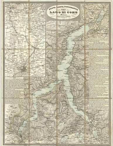
| Title | Nuova carta topografica del Lago di Como. |
| Main title | Mt.: [Milano-Como közti terület.] |
| Subject | A Comoi-tó és környékének topográfiai térképe 1850 körül. |
3298. [Olaszország északi és középső részének térképe. Salzburg–Ró... [B VII b 108]
Institute and Museum of Military History •
B VII b
•
B VII Olaszország
•
B I–XV. Európa
| Title | [Olaszország északi és középső részének térképe. Salzburg–Róma közti rész. Corsica szigetével.] |
3299. Olaszország hegy- és vízrajzi domborművű falitérképe. [B VII b 109]
Institute and Museum of Military History •
B VII b
•
B VII Olaszország
•
B I–XV. Európa
| Title | Olaszország hegy- és vízrajzi domborművű falitérképe. |
3300. Italien. [B VII b 110]
Institute and Museum of Military History •
B VII b
•
B VII Olaszország
•
B I–XV. Európa
| Title | Italien. |
| Main title | Olaszország hegyvízrajzi falitérképe 1952-ben. |